Farringdon station
| Farringdon | |
|---|---|
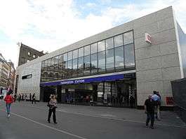 The new National Rail entrance, built as part of the Thameslink Programme. It is built opposite the 1922 station frontage, which still stands. | |
 Farringdon Location of Farringdon in Central London | |
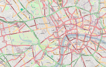
| Location | Clerkenwell |
| Local authority | London Borough of Islington |
| Managed by | London Underground |
| Owner |
Transport for London Network Rail |
| Station code | ZFD |
| DfT category | E |
| Number of platforms |
6 (2 National Rail) (2 London Underground) (2 Under construction for Crossrail) |
| Accessible | Yes[1][2] |
| Fare zone | 1 |
| London Underground annual entry and exit | |
| 2013 |
|
| 2014 |
|
| 2015 |
|
| 2016 |
|
| 2017 |
|
| National Rail annual entry and exit | |
| 2012–13 |
|
| 2013–14 |
|
| 2014–15 |
|
| 2015–16 |
|
| 2016–17 |
|
| – interchange | 0.146 million[4] |
| Key dates | |
| 10 January 1863 | Opened as Farringdon Street |
| 23 December 1865 | Resited |
| 26 January 1922 | Renamed Farringdon & High Holborn |
| 21 April 1936 | Renamed Farringdon |
| 1 July 1936 | Goods yard closed[5] |
| 1982 | Electrified |
| May 1988 | Thameslink started |
| 21 March 2009 | Moorgate branch discontinued |
| Listed status | |
| Listed feature | Underground station |
| Listing grade | II |
| Entry number | 1298047[6] |
| Added to list | 17 May 1994 |
| Other information | |
| Lists of stations | |
| External links | |
| WGS84 | 51°31′12″N 0°06′19″W / 51.520°N 0.1053°WCoordinates: 51°31′12″N 0°06′19″W / 51.520°N 0.1053°W |
|
| |
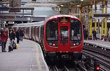
Farringdon is a London Underground and connected main line National Rail station in Clerkenwell, central London. The station is in the London Borough of Islington, just outside the boundary of the City of London. It was opened in 1863 as the terminus of the Metropolitan Railway, which was the world's first underground railway.
Today the Underground station is served by the Circle, Hammersmith & City, and Metropolitan lines between Kings Cross St. Pancras and Barbican. The National Rail station is one of the less important main line central London stations, being a stop on the Thameslink route between St Pancras and City Thameslink, but that is expected to change when it becomes a major interchange station between the two largest transport infrastructure programmes currently under construction in the city: Crossrail and the Thameslink Programme, both scheduled for completion in 2018–2019.
History
The station was opened on 10 January 1863 as the terminus of the original Metropolitan Railway, the world's first underground metro line. The station, initially named Farringdon Street, was originally a short distance from the present station building. The line ran from the Farringdon area to Paddington, a distance of 4 mi (6 km). The station was relocated on 23 December 1865 when the Metropolitan Railway opened an extension to Moorgate. It was renamed Farringdon & High Holborn on 26 January 1922 when the new building by the architect Charles Walter Clark[6] facing Cowcross Street was opened, and its present name was adopted on 21 April 1936.[7] It was built in conjunction with a freight station to take livestock to a slaughterhouse to its south-east to supply Smithfield Market; remains of cattle ramps front the street West Smithfield. Smithfield was redesignated as a wholesale 'deadmeat' market in the 19th century and the Freight station was last used in the 1920s.

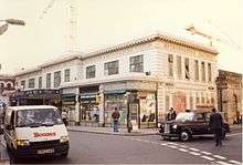
The lines from Farringdon to King's Cross run alongside the Fleet ditch, culverted since 1734.[8] The station building is unusually well-preserved early 20th-century London Underground architecture. It retains indications of the Metropolitan Railway's main-line style operation such as a sign for a Parcel Office on the outer wall and some original signage (with the 1922-1936 name on the façade.
After the bay platforms at Blackfriars closed on 21 March 2009, Southeastern services that previously terminated at Blackfriars were extended to Kentish Town, St. Albans, Luton or Bedford, calling at this station.[9] Thameslink trains to Moorgate ceased at the same time.
Current developments
There are three major rail development projects in progress that involve Farringdon. Crossrail is a new east-west railway scheduled to open in 2018, but now delayed until autumn 2019;[10] the Thameslink Programme is a major upgrade to the existing north-south Thameslink route, enabling longer and more frequent trains, completed in 2018[11] and the Four Lines Modernisation which involves the wholesale resignalling of the London Underground's Sub-surface lines bringing a major boost in capacity to Circle, Hammersmith & City and Metropolitan line services calling at Farringdon once the project is completed by 2023.[12]
Once all projects have been completed by 2023, Farringdon will be one of the country's busiest stations with approximately 200 tph which equals to a departure from the station every 20 seconds.[13] It will be the only station where passengers can change between Crossrail and Thameslink. A new building, housing a dedicated ticket hall, has been constructed to serve these extra passengers. The new building is to the immediate south of the original station, which itself has been upgraded as part of the programme.
An additional entrance has also been built at the north end of the original station, onto Turnmill Street.
Thameslink upgrade
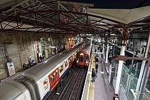
Farringdon Station has been rebuilt[14] to accommodate longer Thameslink trains and to make other improvements to the station.[15] The existing station building has been refurbished with a new roof canopy covering the north end of all four platforms and a new entrance and concourse facing Turnmill Street. An additional ticket hall has been built on the south side of Cowcross Street providing access to the Thameslink platforms, which have been extended southwards underneath this building, allowing the station to handle 240 m (12-carriage) trains. Platforms have been widened to accommodate increased passenger numbers. This process required the bridge that formed Cowcross Street to be demolished and rebuilt.[16] Cowcross Street is now pedestrianised.[17] Lifts have been provided throughout.
The existing listed ticket hall and concourse have been remodelled, for use by London Underground and Thameslink passengers.[18] Interchange within the station has been improved by removing the interchange bridge and installing new stairs and lifts with access to all four platforms, allowing passengers with impaired mobility to use the station.[19]
It was necessary to build the Thameslink platform extensions to the south, since there is a sharp gradient to the immediate north of the station. This resulted in the two-station branch to Moorgate being permanently closed.[20] The platform extensions cross the former Moorgate line and reach within a few metres of the entrance of the Snow Hill Tunnel.[21] The alternative of realigning both the Thameslink and Circle/Hammersmith & City/Metropolitan lines was impractical as the latter crosses over the former on a bridge almost immediately to the north of the station.[21]
Crossrail project
The Farringdon Crossrail station is being built between Farringdon and Barbican Underground stations and it will have interchanges with both of them.[22] Access at the Farringdon end will be via the new Thameslink ticket hall. Work was anticipated to be completed in 2018, but the scheduled opening date was postponed and is now planned for Autumn 2019.[23][24] Crossrail will link Farringdon to Canary Wharf, Abbey Wood, Stratford, and Shenfield in the east with Paddington, Heathrow and Reading in the west . The station will also be a hub for cross-London travel, being the only station to be on both the north-south Thameslink service and the east-west Crossrail service.[25]
Four Lines Modernisation (4LM)
The Circle, District, Hammersmith & City and Metropolitan lines otherwise known as the Sub-Surface lines make up over 40% of the London Underground network moving over 1.3 million passengers everyday stretching from busy commuter hubs to rural backwaters. They also cover some of the oldest infrastructure on the Underground network. For example, Edgware Road signal cabin situated on the Circle, District and Hammersmith & City lines between Baker Street and Paddington opened in 1926 and is still in operation today requiring over 3600 manually operated lever movements a day.[26][27] This ageing system uses fixed block signalling where the track is divided into segments to keep trains a safe distance from each other. At the moment trains run further apart than they need to and data isn't centrally monitored which means that this system requires regular maintenance and faults are more expensive, as well as taking longer to locate and fix any faulty equipment which in-turn reduces service reliability.
Since the Sub-Surface lines are closely interlinked Transport For London announced in March 2015 that the Sub-surface lines would be subject to a wholesale re-signalling programme to be known collectively as the Four Lines Modernisation or 4LM for short. The upgrade will replace all the signalling equipment on all four lines which will be monitored from a new control centre currently under construction in Hammersmith replacing the numerous signal cabins and service control centres across the four lines.[26]
The new signalling system uses the Thales SelTrac moving block system otherwise known as Communications Based Train Control (CBTC) which uses Wifi to constantly let controllers know where trains are and how fast they are going. Precise speeds will be set by computers so trains will be able to run at higher speeds and closer together with a maximum service frequency of 32 trains per hour (every 2 minutes) in central London by the time the upgrade is complete in 2023. As well as reducing journey times a 33% increase in capacity will be created on all four lines making the best use out of 192 S-Stock trains which too have a universal design exclusively for the Sub-surface lines.[26]
Timeline[12]
- From 2021: more frequent trains in Zone 1 (30 trains per hour) at the busiest times
- From 2022: more frequent services in central London (up to 32 tph at peak times) and increases on the rest of the Metropolitan, District, and Hammersmith and City lines both at peak and off-peak periods
- From 2023: a further increase in services on the Metropolitan line at peak times, and increases in off peak services across all four lines
Dual traction current supply
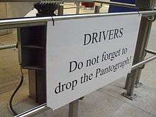
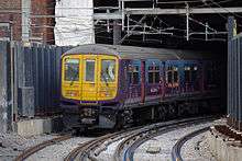
Farringdon station is notable because Thameslink trains switch between the 25 kV AC overhead supply used to the north of London and the 750 V DC third rail supply used to the south whilst standing at the platform. The trains that formerly ran to Moorgate used 25 kV AC throughout their journeys. This project was installed by the Network SouthEast sector of British Rail in May 1988.

Until the start of the Thameslink Programme southbound trains that were unable to switch to DC were taken out of service at Farringdon and stabled at Moorgate to prevent them from blocking the core section of the Thameslink route. As this option is no longer possible the catenary has been extended to City Thameslink to enable these trains to continue to the southbound platform[28] at City Thameslink using AC and then return northwards using the new crossover in Snow Hill Tunnel.[29] The pantograph on southbound trains is normally lowered at Farringdon.
Underground trains serving Farringdon use the four-rail 630 V DC system.
Accidents and incidents
- On 5 January 1867, 16 people were injured at Farringdon Street station in a rear-end collision caused by a signaller's error.[30]
- On 5 January 1892, a defective axlebox resulted in the derailment of part of a train shortly after it had departed Farringdon Street. Five passengers were injured.[31]
- On 26 November 1907, a train in the process of departing Farringdon Street was rear-ended by a second train entering the station.[32]
- On 1 May 1939, a total of 31 people were injured when a Circle line train was involved in a minor collision with a railway engine. Seventeen passengers reported they had suffered shock and injury while a further nine subsequently complained that they had incurred minor injuries. Five crew members were also injured.[33]
- On 22 May 1954, three people in a lorry were killed when it fell from a bridge on to the tracks near Farringdon. A goods train collied with the lorry shortly after departing Farringdon.[34][35]
Services
London Underground
The London Underground part of the station is served by the Metropolitan, Hammersmith & City and Circle lines, between King's Cross St. Pancras and Barbican. All three lines share the same pair of tracks from Baker Street Junction to Aldgate Junction making this section of track one of the most intensely used on the London Underground network.
Circle line
The typical service in trains per hour (tph) is:[36]
- 6 tph Clockwise via Liverpool Street and Tower Hill
- 6 tph To Hammersmith via King's Cross St. Pancras and Paddington
Hammersmith & City line
The typical service in trains per hour (tph) is:[36]
- 6 tph Eastbound to Barking
- 6 tph Westbound to Hammersmith via Paddington
Metropolitan line
The Metropolitan line is the only line to operate express services, though currently this is only during peak times (Westbound 06:30–09:30 / Eastbound 16:00–19:00). Fast services run non-stop between Wembley Park, Harrow-on-the-Hill and Moor Park. Semi-fast services run non-stop between Wembley Park and Harrow-on-the-Hill.[37]
The typical off-peak service in trains per hour (tph) is:[38]
- 12 tph Eastbound to Aldgate
- 2 tph Westbound to Amersham (all stations)
- 2 tph Westbound to Chesham (all stations)
- 8 tph Westbound to Uxbridge (all stations)
Off-peak services to/from Watford terminate at Baker Street
The typical peak time service in trains per hour (tph) is:[38]
- 14 tph Eastbound to Aldgate
- 2 tph Westbound to Amersham (fast in the evening peak only)
- 2 tph Westbound to Chesham (fast in the evening peak only)
- 4 tph Westbound to Watford (semi-fast in the evening peak only)
- 6 tph Westbound to Uxbridge (all stations)
Farringdon is in Transport for London's Travelcard Zone 1.
National Rail
All National Rail services at Farringdon are served by Thameslink trains between St Pancras International and City Thameslink using part of the City Widened Lines and Snow Hill Tunnel respectively.
The new Thameslink timetable through London Bridge was introduced in May 2018, the current off peak service is as follows:
- Southbound
- 4 tph to Brighton via Gatwick Airport (Thameslink)
- 2 tph to Horsham via Gatwick Airport (Thameslink)
- 2 tph to Gatwick Airport via Redhill (Thameslink)
- 2 tph to Rainham via Greenwich, Charlton, Abbey Wood, Dartford, Gravesend and Gillingham (Thameslink)
- 2 tph to Orpington
- 4 tph to Sutton, 2 tph via Wimbledon and 2 tph via Mitcham Junction.
- Northbound
- 4 tph to Bedford via St Pancras International, St Albans City, Luton Airport and Luton Town. (operated by Thameslink)
- 2 tph to Luton Town via St Pancras International, St Albans City and Luton Airport
- 4 tph to St Albans City via St Pancras International
- 2 tph to Kentish Town via St Pancras International
- 2 tph to Cambridge via St Pancras International, Stevenage and Hitchin (Thameslink)
- 2 tph to Peterborough via St Pancras International, Stevenage and Hitchin (Thameslink)
After midnight, on all days, a half-hourly service runs between Bedford and Three Bridges.[39]
Prior to 2009, Thameslink services also ran to Moorgate via Barbican with trains diverging of the core route east of the platforms at Farringdon, this section of line was closed as part of the Thameslink Programme which involved the construction of a new ticket hall and the lengthening of platforms at Farringdon to enable platform extensions to accommodate longer 12 carriage trains which covered over the junction in the process.
Farringdon is in Transport for London's Travelcard Zone 1.
Connections
London Buses routes 63 and 172, and night route N63 serve the station.
References
- ↑ "Step free Tube Guide" (PDF). Transport for London. Archived (PDF) from the original on 13 June 2018.
- ↑ "London and South East" (PDF). National Rail. September 2006. Archived from the original (PDF) on 6 March 2009.
- 1 2 3 4 5 "Multi-year station entry-and-exit figures" (XLSX). London Underground station passenger usage data. Transport for London. January 2018. Retrieved 22 July 2018.
- 1 2 3 4 5 6 "Station usage estimates". Rail statistics. Office of Rail Regulation. Please note: Some methodology may vary year on year.
- ↑ Hardy, Brian, ed. (March 2011). "How it used to be – freight on The Underground 50 years ago". Underground News. London Underground Railway Society (591): 175–183. ISSN 0306-8617.
- 1 2 "Farringdon". The National Heritage List for England. English Heritage. Archived from the original on 17 August 2013.
- ↑ Rose, Douglas (1999). The London Underground: A diagrammatic history. Capital Transport Publishing. ISBN 1-85414-219-4.
- ↑ "The Farringdon Wards of the City of London ... some notes on their history" p5: T Sharp 2000
- ↑ "Train times 22 March – 16 May 2009 Thameslink route" (PDF). First Capital Connect. Archived from the original (PDF) on 19 April 2009.
- ↑ "Crossrail". Wikipedia. 13 March 2017.
- ↑ "Thameslink Programme". Wikipedia. 7 March 2017.
- 1 2 Matters, Transport for London | Every Journey. "Four Lines Modernisation". Transport for London. Retrieved 21 March 2017.
- ↑ Londonist Ltd (9 April 2015), New Thameslink Trains Revealed, retrieved 21 March 2017
- ↑ "Whats happening at Farringdon?". Network Rail. Archived from the original on 23 June 2011.
- ↑ "The new Farringdon station". Network Rail. Archived from the original on 8 October 2012.
- ↑ Network Rail (2004a) – pg.27, paragraph 2.6.5
- ↑ "Thameslink 2000 Environmental Statement: Addendum" (PDF). Network Rail. 1 July 2005. Archived from the original (PDF) on 25 September 2007.
See page 15, paragraph 2.2.1
- ↑ Network Rail (2004a) – page 27, paragraph 2.6.3
- ↑ Network Rail (2004a) – pg.27, paragraph 2.6.4
- ↑ Network Rail (2005a) – pg.9, paragraph 2.1.1
- 1 2 Network Rail (2005a) – pg.9, paragraph 2.1.5
- ↑ "Farringdon" (PDF). Crossrail. 28 October 2006. Archived from the original (PDF) on 28 September 2007.
- ↑ "Crossrail website". Crossrail. Archived from the original on 23 April 2010.
- ↑ "Capital's key services protected, says Johnson". The Press Association. 20 October 2010.
- ↑ "Farringdon Station". Crossrail. Archived from the original on 30 April 2011.
- 1 2 3 Transport for London (11 January 2017), Transforming the Circle, District, Hammersmith & City and Metropolitan Lines, retrieved 21 March 2017
- ↑ Transport for London (24 March 2015), London Underground modernisation: the next four lines, retrieved 21 March 2017
- ↑ Network Rail – 'Kent & Sussex Sectional Appendix', LOR S0280, Seq 001, "Farringdon to City Thameslink" (last updated 31 December 2010)
- ↑ "City Thameslink ('Powered Up' section)". Thameslink Programme FAQ. Archived from the original on 9 November 2008.
- ↑ "Accident at Farringdon Street on 5th January 1867".
- ↑ "Accident at Farringdon Street – Kings Cross on 5th January 1892".
- ↑ "Accident at Farringdon Street on 26th November 1907".
- ↑ "Accident at Farringdon on 1st May 1939".
- ↑ "Three Killed in Crash - Lorry Falls from Bridge to Railway". The Times (52939). 24 May 1954. p. 4. Retrieved 1 July 2018.
- ↑ "Accident at Farringdon on 22nd May 1954".
- 1 2 "Circle and Hammersmith & City line WTT" (PDF). Transport for London. Archived from the original (PDF) on 11 November 2016.
- ↑ "CULG – Metropolitan Line". www.davros.org. Retrieved 19 March 2017.
- 1 2 "Metropolitan line WTT" (PDF). Transport for London. Archived from the original (PDF) on 1 July 2016.
- ↑ "First Capital Connect timetables". Archived from the original on 4 August 2014. Retrieved 25 May 2012.
External links
| Wikimedia Commons has media related to Farringdon station. |
- "Tube departure board for Farringdon station". TfL.
- "Farringdon station". Thameslink Programme. Thameslink. Archived from the original on 3 February 2009.
| Preceding station | Following station | |||
|---|---|---|---|---|
towards Hammersmith | Circle line | |||
| Hammersmith & City line | towards Barking |
|||
| Metropolitan line | towards Aldgate |
|||
| Preceding station | Following station | |||
| Thameslink | ||||
| Future Development | ||||
| Preceding station | Following station | |||
| Crossrail Elizabeth line | ||||
| Former services | ||||
| Preceding station | Following station | |||
towards Hammersmith | Metropolitan line Hammersmith branch (1864–1990) | towards Barking |
||
| Abandoned plans | ||||
| Preceding station | Following station | |||
| Clerkenwell towards Hammersmith, Kensington (Addison Road), Uxbridge, Chesham, Verney Junction or Brill |
Metropolitan Railway | Aldersgate Whitechapel | ||
| Disused railways | ||||
| Preceding station | Following station | |||
| King's Cross Thameslink (before December 2007) |
First Capital Connect City Widened Lines |
Barbican | ||
| King's Cross Metropolitan or King's Cross York Road |
British Rail Eastern Region City Widened Lines |
Barbican | ||
| Stations |
| ||||||
|---|---|---|---|---|---|---|---|
| Rolling stock | |||||||
| History |
| ||||||
| See also | |||||||
| |||||||
| Stations |
| ||||
|---|---|---|---|---|---|
| Rolling stock | |||||
| History |
| ||||
| See also | |||||
| |||||
| Stations |
| ||||||||||||||||
|---|---|---|---|---|---|---|---|---|---|---|---|---|---|---|---|---|---|
| Rolling stock |
| ||||||||||||||||
| History |
| ||||||||||||||||
| Future proposals |
| ||||||||||||||||
| |||||||||||||||||
| Stations |
| ||||||||||
|---|---|---|---|---|---|---|---|---|---|---|---|
| Rolling stock |
| ||||||||||
| Operations | |||||||||||
| Related routes | |||||||||||
| |||||||||||