Paddington tube station (Bakerloo, Circle and District lines)
| Paddington | |
|---|---|
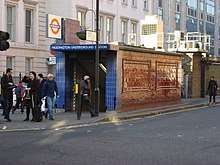
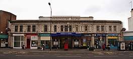 Entrance on Praed Street | |
 Paddington Location of Paddington in Central London | |
| Location | Paddington |
| Local authority | City of Westminster |
| Managed by | London Underground |
| Number of platforms | 4 |
| Accessible | Yes (change between Circle and District lines)[1] |
| Fare zone | 1 |
| OSI |
Marylebone Lancaster Gate Paddington Paddington Circle and Hammersmith & City lines station |
| London Underground annual entry and exit | |
| 2013 |
|
| 2014 |
|
| 2015 |
|
| 2016 |
|
| 2017 |
|
| Key dates | |
| 1868 | Opened (MR) |
| 1913 | Opened (BS&WR, as terminus) |
| 1915 | Extension (BS&WR) |
| 1926 | Started (District line) |
| 1949 | Started (Circle line) |
| Listed status | |
| Listed feature | Circle and District line Station |
| Listing grade | II |
| Entry number | 1392020[4] |
| Added to list | 11 August 2003 |
| Other information | |
| Lists of stations | |
| External links | |
| WGS84 | 51°30′56″N 0°10′31″W / 51.515430°N 0.175409°WCoordinates: 51°30′56″N 0°10′31″W / 51.515430°N 0.175409°W |
|
| |
Paddington is a London Underground station served by the Bakerloo, Circle and District lines. It is located on Praed Street to the south of Paddington mainline station and has entrances from Praed Street and from within the mainline station. On the Bakerloo line the station is between Warwick Avenue and Edgware Road and on the Circle and District lines it is between Bayswater and Edgware Road. It is in London Fare Zone 1.
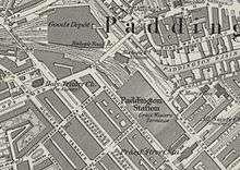
The station is in two parts: sub-surface platforms, opened in 1868 and deep-level platforms, opened in 1913. It is one of two separate Underground stations of the same name. The other station, to the north of the mainline station, is served by the Circle and Hammersmith & City lines. Although shown on the London Underground map as a single station,[5] the two stations are not directly linked and interchange between them is via the concourse of the mainline station.
History
Sub-surface station
The Circle line and District line share tracks in the sub-surface station. It was opened as Paddington (Praed Street) by the Metropolitan Railway (MR, later the Metropolitan line) on 1 October 1868 when the company opened a branch from its main route between Hammersmith and Moorgate Street.[6] The branch ran southwards to Brompton (Gloucester Road) and was planned as part of the Inner Circle, a circuitous route being constructed in conjunction with the District Railway (DR, now the District line) that was intended to link most of the capital's mainline stations.[7][n 1] The extension was constructed mostly in shallow tunnels using the cut-and-cover technique.[8][n 2] Services were provided by both the MR and the DR, with each company running Inner Circle trains over the other's tracks.[6]
The station has two platforms positioned in a cutting partially covered with a glazed roof and partially exposed to the atmosphere. It was designed by John Fowler the MR's chief engineer. The brick-built street-level entrance building featured a balustrade along the edge of the roof decoratively topped with urns. Fowler's building was demolished and reconstructed to a design by the MR's architect Charles W Clark in 1914 with a cladding of white faïence blocks. The building is listed Grade II by Historic England.[4] The brickwork of the platform retaining walls was restored in 1986 during a renovation of the station.[9]
The station was the second opened by the MR at Paddington. The earlier station, named Paddington (Bishop's Road), opened on the 10 January 1863.[6] It is north of the mainline station and is served by trains on the Hammersmith branch.
From 1 November 1926, the MR provided all Inner Circle services.[6] DR services on the west side of the circular route terminated at Edgware Road using two platforms that had been constructed by the MR for an abandoned plan for a new route between Edgware Road and Finchley Road.[6][10] "Praed Street" was dropped from the name of the sub-surface station on 11 July 1947 to match the name used for the deep-level platforms.[6] From 1949, the Circle line was identified on tube maps as a separate line replacing the Metropolitan line service.[6]
The sub-surface station has twice been damaged by explosions. On 30 October 1883, a bomb planted by Fenians campaigning for an independent Irish Republic exploded on a train near the station. The bomb damaged the train it was on and a passing train along with part of the station and the signal box. Sixty-two passengers were injured.[11][n 3] On the night of 13 October 1940, the station was hit by German bombs dropped during The Blitz killing five people in the station with four more subsequently dying of injuries.[12]
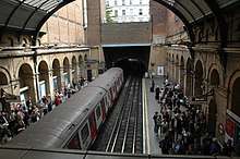
Deep-level station
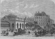
The deep-level station was opened by the Baker Street and Waterloo Railway (BS&WR, later the Bakerloo line) on 1 December 1913 as the temporary terminus of its extension from Edgware Road.[6] To enable the BS&WR to continue its route to the north-west of Paddington, the station platforms were constructed in a tight curve.[13] A cross-over between tracks and reversing tunnels were provided beyond the new station.[14] Construction work continued beyond the station to extend the line further to Queen's Park where it met the mainline tracks of the London and North Western Railway. The extension opened in stages, with the first trains running to and from Warwick Avenue on 31 January 1915.[6]
Unlike most previous BS&WR stations, a separate station building was not constructed at Paddington. A small pedestrian entrance on the north-west corner of the junction of London Street and Praed Street provides access to the below-ground ticket hall. Following their successful introduction at Earl's Court in 1911, the station was the first on the line to be designed to use escalators instead of lifts.[14] The ticket hall and platforms are decorated with tiling designs by David Hamilton installed during a £6 million refurbishment of the station between 1984 and 1987 incorporating elements of technical drawings by Marc Isambard Brunel and other engineers.[9][15][16]
Between April and August 2016 the Bakerloo line platforms were closed to enable escalator replacements and the construction of connecting passageways to the new Crossrail platforms due to open in 2018.[17] In December 2016 Westminster City Council approved proposals to construct a new mixed-use development called Paddington Quarter on a site adjacent to the mainline station. The plans include reconstruction of the Bakerloo line station to provide a larger ticket hall and better access between platforms and street level.[18][19]
Arrangement
The station has three ticket halls: one for the Circle and District lines above the platforms of the sub-surface station, one below ground for the Bakerloo line station and one under the mainline station. The sub-surface station and the deep-level station ticket halls are linked via the ticket hall under the mainline station, but not to each other directly. Entrances are on Praed Street and from within the mainline station.[20] On the tube map the station is shown jointly with the other separate Underground station and passenger usage data for both is combined.[3] Interchange with the other station is through the mainline station concourse without extra charge if the change is made within the permitted time.[2][n 4]
Services
The station is between Bayswater and Edgware Road stations on the Circle and District lines and between Warwick Avenue and Edgware Road on the Bakerloo line. It is in London Fare Zone 1.[22] Train frequencies vary throughout the day, but, generally, Circle line trains run every 10 minutes from approximately 05:31 to 00:39 eastbound and 05:07 to 00:45 westbound; they are supplemented by District line trains that operate every 10 minutes from approximately 05:44 to 00:06 eastbound and 05:57 to 00:22 westbound.[23][24] Some late night Circle line trains continue beyond Edgware Road.[23] Bakerloo line trains generally operate every 3 minutes from approximately 05:45 to 00:22 southbound and 05:55 to 00:41 northbound.[25]
Connections
London Buses routes 7, 23, 27, 36, 205, 332 and night routes N7, N205 serve Praed Street.[26]
Lancaster Gate Underground station on the Central line and Marylebone mainline station are within walking distance and out of station interchanges to these stations are permitted at no extra cost if made within the permitted time.[2]
Notes and references
Notes
- ↑ The extension had been approved by the Metropolitan Railway (Notting Hill and Brompton Extension) Act which received royal assent on 29 July 1864. A second act, the Metropolitan Railway (Tower Hill Extension) Act, received royal assent on the same day permitting the MR to extend its line eastwards from Moorgate to Tower of London.[7]
- ↑ Two months after opening the extension to Gloucester Road, The MR was extended again to South Kensington to connect to the DR when it opened on 24 December 1868 between South Kensington and Westminster Bridge.[6][8]
- ↑ A few minutes after the Praed Street explosion, a bomb exploded in the tunnel between Charing Cross (now Embankment) and Westminster stations, though no trains were damaged or passengers injured in this incident.[11]
- ↑ Although the two Paddington Underground stations are only about 400 metres (440 yd) apart geographically, the distance by rail on the Circle line without changing trains is 20.84 kilometres (12.95 mi) around almost the whole of the line's loop section.[21]
References
- ↑ "Step free Tube Guide" (PDF). Transport for London. Archived (PDF) from the original on 13 June 2018.
- 1 2 3 "Out of Station Interchanges" (XLS). Transport for London. May 2011. Archived from the original on 20 October 2012.
- 1 2 3 4 5 6 "Multi-year station entry-and-exit figures" (XLSX). London Underground station passenger usage data. Transport for London. January 2018. Retrieved 22 July 2018.
- 1 2 Historic England. "Paddington, District and Circle Line Underground Station (1392020)". National Heritage List for England. Retrieved 3 April 2015.
- ↑ "Standard Tube Map" (PDF). Transport for London. December 2016. Retrieved 19 February 2017.
- 1 2 3 4 5 6 7 8 9 10 Rose 1999.
- 1 2 Day & Reed 2010, p. 18.
- 1 2 Day & Reed 2010, p. 20.
- 1 2 Day & Reed 2010, p. 189.
- ↑ Jackson 1986, pp. 271–272.
- 1 2 Day & Reed 2010, p. 176.
- ↑ Cooper 2014.
- ↑ Horne 2001, p. 28.
- 1 2 Horne 2001, p. 29.
- ↑ Lawrence 1994, p. 181.
- ↑ "David Hamilton - Paddington Station". David Hamilton. Retrieved 23 July 2017.
- ↑ "Major improvement works at Paddington paves the way for Crossrail". Transport for London. 19 February 2016. Retrieved 23 July 2017.
- ↑ "Paddington Quarter - A Great Western Development Project". Sellar Paddington Limited. 2016. Retrieved 23 July 2017.
- ↑ Jahshan, Elias (7 December 2016). "London's "game-changing" Paddington Quarter development approved". Retail Gazette. Retrieved 23 July 2017.
- ↑ "Station Layout: Paddington (Circle and Bakerloo lines)". Ian Visits - 3D Maps of Every Underground Station. Retrieved 4 March 2017.
- ↑ Rail distance calculated from kilometerage data at "Circle Line, Toplogy". Clive's Underground Line Guides. Retrieved 25 February 2017.
- ↑ "Tube Map" (PDF). Transport for London. July 2017. Retrieved 1 August 2017.
- 1 2 "Circle line timetable". Transport for London. Retrieved 4 March 2017.
- ↑ "District line timetable". Transport for London. Retrieved 4 March 2017.
- ↑ "Bakerloo line timetable". Transport for London. Retrieved 4 March 2017.
- ↑ "Buses from Paddington" (PDF). Transport for London. 19 November 2016. Archived from the original (PDF) on 5 March 2017. Retrieved 4 March 2017.
Bibliography
- Cooper, Nick (2014). London Underground at War. Amberley Publishing. ISBN 978-1-4456-2217-0.
- Day, John R.; Reed, John (2010) [1963]. The Story of London's Underground (11th ed.). Capital Transport. ISBN 978-1-85414-341-9.
- Horne, Mike (2001). The Bakerloo Line: An Illustrated History. Harrow: Capital Transport. ISBN 978-1-85414-248-1.
- Jackson, Alan (1986). London's Metropolitan Railway. David & Charles. ISBN 0-7153-8839-8.
- Lawrence, David (1994). Underground Architecture. Capital Transport. ISBN 978-1-85414-160-6.
- Rose, Douglas (1999) [1980]. The London Underground, A Diagrammatic History. Douglas Rose/Capital Transport. ISBN 1-85414-219-4.
External links
| Wikimedia Commons has media related to Paddington tube station (Bakerloo, Circle and District lines). |
| Preceding station | Following station | |||
|---|---|---|---|---|
towards Harrow & Wealdstone | Bakerloo line | towards Elephant & Castle |
||
| Circle line | Terminus |
|||
towards Wimbledon | District line Wimbledon-Edgware Road |
| Stations |
| ||||||||||
|---|---|---|---|---|---|---|---|---|---|---|---|
| Rolling stock | |||||||||||
| Depots | |||||||||||
| History |
| ||||||||||
| |||||||||||
| Stations |
| ||||||
|---|---|---|---|---|---|---|---|
| Rolling stock | |||||||
| History |
| ||||||
| See also | |||||||
| |||||||