Croxley Rail Link
| Croxley Rail Link | |
|---|---|
 The disused line at Watford West railway station. | |
| Overview | |
| Type | Rapid transit |
| System | London Underground |
| Status |
Approved for re-opening Suspended due to funding |
| Locale | Hertfordshire |
| Termini |
Croxley Watford Junction |
| Stations | 3 |
| Operation | |
| Planned opening | 2020[1][2][3] |
| Operator(s) | Transport for London |
| Technical | |
| Line length | 3.4 mi (5.47 km) |
| Track gauge | 4 ft 8 1⁄2 in (1,435 mm) |
Croxley Rail Link | ||||||||||||||||||||||||||||||||||||||||||||||||||||||||||||||||||||||||||||||||||||||||||||||||||||||||||||||||||||||||||||||||||||||||||||||||||||||||||||||||||||||||||||||||||||
|---|---|---|---|---|---|---|---|---|---|---|---|---|---|---|---|---|---|---|---|---|---|---|---|---|---|---|---|---|---|---|---|---|---|---|---|---|---|---|---|---|---|---|---|---|---|---|---|---|---|---|---|---|---|---|---|---|---|---|---|---|---|---|---|---|---|---|---|---|---|---|---|---|---|---|---|---|---|---|---|---|---|---|---|---|---|---|---|---|---|---|---|---|---|---|---|---|---|---|---|---|---|---|---|---|---|---|---|---|---|---|---|---|---|---|---|---|---|---|---|---|---|---|---|---|---|---|---|---|---|---|---|---|---|---|---|---|---|---|---|---|---|---|---|---|---|---|---|---|---|---|---|---|---|---|---|---|---|---|---|---|---|---|---|---|---|---|---|---|---|---|---|---|---|---|---|---|---|---|---|---|
| ||||||||||||||||||||||||||||||||||||||||||||||||||||||||||||||||||||||||||||||||||||||||||||||||||||||||||||||||||||||||||||||||||||||||||||||||||||||||||||||||||||||||||||||||||||
Notes:
| ||||||||||||||||||||||||||||||||||||||||||||||||||||||||||||||||||||||||||||||||||||||||||||||||||||||||||||||||||||||||||||||||||||||||||||||||||||||||||||||||||||||||||||||||||||
The Croxley Rail Link, or the Metropolitan Line Extension, was a proposed railway engineering project in the Watford and Three Rivers districts of Hertfordshire, England, that would have connected the London Overground and the London Underground's Metropolitan line at Watford Junction. The Metropolitan line's terminus at Watford Underground station would have closed and the line would have been diverted and extended from Croxley to Watford Junction via a reopened section of closed line. The main proponent of the scheme is Hertfordshire County Council but failed to win the support of Transport for London (TfL) which owns the Watford branch.[4][5][6][7][8][9][10][11] The engineering works would have consisted of the realignment of the disused Watford and Rickmansworth Railway's line between Croxley Green and Watford High Street, with the construction of a viaduct over the Grand Union Canal, River Gade and A412 road and two new stations before branching into the London Overground line near Watford High Street and continuing to Watford Junction.[12]
The proposed route was featured in a Transport for London network map for 2016[13] and the Transport for London Indicative 2025 Transport Map on which Watford tube station does not appear.[14] Were the link to be built, direct services between Watford Junction and Amersham would be possible but are not included in the business case for the scheme.[9]
The project was approved by the Government on 14 December 2011[15] and clearing vegetation started during 2013.[2][16][17] The project received final Government approval through an Order of the Transport and Works Act on 24 July 2013[18] and was signed off and formally given the green light by the government on 17 March 2015 when it was confirmed that Transport for London would be responsible.[2][19] Work on the extension stopped in 2016 due to anticipated cost overruns and an unresolved dispute over funding.
History

The present-day London Underground Watford Met station is situated close to Cassiobury Park and somewhat peripheral to the town centre. Watford Urban District Council objected to the proposal to drive a railway across the park, resulting in the terminus of the Watford branch being a mile (1.6 km.) from the High Street.[20]
Also in the area was the single-track Watford and Rickmansworth Railway that opened in 1862 between Watford Junction and Rickmansworth (Church Street). British Rail withdrew passenger services from the Rickmansworth branch in 1952 and ran a skeleton service on the Croxley Green branch until 1996.[21]
Over the years, various schemes were considered to extend the Metropolitan line into the centre of Watford, including an abandoned plan in 1927 to open a Metropolitan Railway station on the High Street, Watford Central.[22] In 1948, the London Transport Executive (LTE), part of the British Transport Commission, considered a proposal to link the Metropolitan line to the BR Croxley Green branch line.[23] A similar proposal was put forward by London Regional Transport (LRT) around 1994.[24] Because the line lay entirely within Hertfordshire, it was championed by the county council who lobbied for funding from LRT (later TfL) and the Department for Transport for 16 years.[25]
Funding
In 2005 Transport for London (TfL) tentatively committed to providing up to £18m of the estimated cost of £65m, predicting that the link would be operational by 2010.[2][26] Difficulties arose in securing the remaining funding from the Department for Transport (DfT) and a revised project submission, under new guidelines, was prepared, with a view to obtaining Programme Entry status. A business case was submitted to the DfT in February 2008, with revised costs of £95m.[27] The proposal was rejected in March on the basis that no guarantee of financial backing had been received from TfL.[28] In July 2008 the East of England Regional Assembly declared the scheme a "priority" and agreed to contribute £119.5m[29] towards the estimated cost, now £150m.[30] Hertfordshire County Council (HCC) agreed to allocate £25.8m which it hoped to recover through ticket sales and other London Underground revenue.[31] It was predicted that the link could be operational within seven years.[29]
A revised business case was produced in autumn 2009 and the costs and scope reviewed. Following the Cameron–Clegg coalition's Comprehensive Spending Review the project was placed in the pre-qualification pool and a further submission made to the Department for Transport in January 2011. In February 2011 the Department for Transport placed the project into a qualification pool of works that would be subjected to further assessments in order to bid for funding. A Best and Final Funding Bid was submitted to the Department in September 2011.[32] On 14 December 2011, the Department for Transport agreed to fund £76.2m of the £115.9m cost,[33] with the remainder from the local authorities (£33.7m) and third parties (£6.86m).[16]
In December 2014, Hertfordshire County Council announced that the projected cost of the scheme would rise to £230 million. It was also reported that London Underground could take over construction of the link from Network Rail.[34] According to TfL, HCC had significantly underestimated the costs and the project was faced with "significant project slippage and cost escalation", and for this reason an agreement was reached with the DfT and HCC whereby London Underground would assume full responsibility for the project, subject to a suitable funding package. Hertfordshire County Council will now contribute £230m, £34m will be provided by central government, and LU is to contribute £16m. The opening date was put back to 2020.[2][19]
On 25 January 2017, the Watford Observer newspaper published an update on the Croxley Rail Link, supplemented in March, confirming work had stopped as there was an ongoing funding issue; Transport for London were stating that more than £50m additional funding was required. A Freedom of Information request revealed that £130m of the £284m funding had already been spent, but the only works that have actually been delivered are some utility diversions and route clearance.[35][36] The future of the project was now ambiguous.[37][38][39][40]
A decision of the Mayor of London, Sadiq Khan, in September 2017 and the supporting documentation gave more clarity to the issue. and relieved Transport for London of the obligation to fund any cost overrun which had been imposed on it by the previous Mayor Boris Johnson.[41] It was noted that at the budgeted cost of £284.4m, the cost benefit ratio of the project was only 0.4, so funding a cost overrun now estimated at £73.4m on top of the £49.2m Transport for London were already contributing, would not give value for money. It stated that Transport for London's sunk expenditure on the project is £71.2m, of which £15.5m was for buying an additional train, which has been delivered and put into service.
In 2018, the government offered Transport for London the £73.4m additional funding it was apparently asking for, taking total funding available to £357.8m, subject to Transport for London accepting cost overrun risk again. This arrangement was turned down by the Mayor.[42] The parties were later reported to be examining cheaper alternative schemes such as a rapid bus transit scheme and light rail.[43]
Proposed route and stations
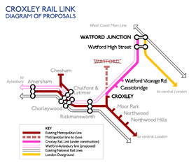
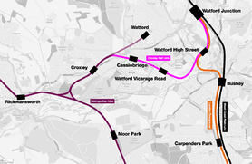
A key part of the project was the construction of the "missing link", a short line of track that would have connected the existing Metropolitan line to the former British Rail Croxley Green branch line at their closest point; achieved by a new junction near Baldwins Lane, about 1 kilometre (0.6 mi) northeast of Croxley station and a viaduct and a bridge to carry the Metropolitan line over the A412 Watford Road dual carriageway and the Grand Union Canal[44] to the former BR line. Double track would have been laid along the disused trackbed, reinstating the line as far as Watford High Street.[45]
None of the former BR stations that closed in 1996 will reopen. Two new stations were to be built: Croxley Green station replaced by Cassiobridge[46] (previously intended to be called "Ascot Road") and a second station, Watford Vicarage Road, would have replaced Watford West and the football specials halt, Watford Stadium Halt.[46][47] The new stations would have had ticket machines instead of a staffed ticket office.[48][49]
Stations
| Station | Status | notes |
|---|---|---|
| Watford Junction |
existing | |
| Watford High Street |
existing | |
| Watford Stadium Halt | closed 1996 | would be replaced by Watford Vicarage Road |
| Watford Vicarage Road | new station | |
| Watford West | closed 1996 | would be replaced by Watford Vicarage Road |
| Cassiobridge | new station | |
| Croxley Green | closed 1996 | would be replaced by Cassiobridge |
| Watford |
uncertain | would be replaced by Cassiobridge |
| Croxley |
existing |

The name Ascot Road was initially chosen by consultants for the first of the two new stations; however, many local people and councillors felt that this name would not reflect the identity of the area. Transport planners also expressed concern that the new Tube station may be too easily confused with Ascot Station in Berkshire. The name Cassiobridge was suggested due to historical connections with the area and because of a bridge over the Grand Union Canal, and after some consultation, it was confirmed in August 2013 that the Cassiobridge name would be used instead.[46][50]
The planned Watford Hospital station had its name changed to Watford Vicarage Road because it was felt that the association with Vicarage Road football stadium would ensure wider recognition outside the local area.[46][47][50]
Watford Met station
Transport for London had stated that passenger services on the Metropolitan line from Croxley to Watford would cease when the Croxley Rail Link opens; Watford Met station would close, although the short branch may remain in operation as a reversing siding. Following closure, the nearest new station to Watford Met would have been Cassiobridge, about 3⁄4 mile (1.2 km) away. The plan to close the station has been the subject of some local opposition, and campaigners argued for a reduced shuttle service to be operated on the branch.[51]
Ending services on part of the line and closing a station require a formal closure process involving London TravelWatch.[12] The London TravelWatch Board set up a Watford Station Closure Panel. The panel held a public meeting in Watford on 14 June 2012 to present arguments to TfL against the station closure.[52][53]
Amersham link
There was a further suggestion that use of the existing, but seldom-used, Metropolitan line chord which allows trains to run from Watford towards Amersham via Rickmansworth in conjunction with this rail Link, direct services between Watford Junction and Amersham might be possible some time in the future.[9][54] London Regional Transport's adapted internal planning Tube map of 1994 illustrated this idea.[24]
The proposal was included in a Greengauge 21 report "Capturing the Benefits of HS2 on Existing Lines"."[55] The report proposes that High Speed Two would increase capacity on the West Coast Mainline, increasing the benefits of an "Amersham Link" to the Croxley Link. These benefits would be further increased by the planned substantial increase in service to Watford Junction and London Euston. It is claimed that this could support a new service from Aylesbury and other London to Aylesbury Line destinations to Watford Junction."[55]
Watford Health Campus
The proposed route would have been near Watford General Hospital. Plans for a major development include a hotel and retail, business and residential developments.[56] It will take 15–20 years to complete.[57]
References
- ↑ "Croxley Rail Link update". 17 December 2014. Archived from the original on 9 January 2015.
- 1 2 3 4 5 Knowles, Michael (30 July 2015). "Croxley Rail Link will not be completed until 2020, documents reveal". Watford Observer. Retrieved 1 December 2015.
- ↑ "Metropolitan line extension". Transport for London. Retrieved 30 May 2016.
- ↑ Duggan, Emma (25 January 2017). "UPDATE: Met Line extension: Mayor confirms work has stopped". Watford Observer. Archived from the original on 8 August 2018. Retrieved 8 August 2018.
- ↑ Simpson, Jack. "Metropolitan line extension's future unclear as £50m black hole revealed". Construction News. Archived from the original on 15 March 2017. Retrieved 8 August 2018.
- ↑ https://tfl.gov.uk/travel-information/improvements-and-projects/metropolitan-line-extension
- ↑ http://www.watfordobserver.co.uk/news/15158140.Metropolitan_Line_Extension__Everything_you_need_to_know_about_the_project/
- ↑ http://www.watfordobserver.co.uk/news/15896867.mayor-sadiq-khan-says-tfl-will-not-pay-for-met-line/
- 1 2 3 Wood, John (March 2006). "Hertfordshire's Local Transport Plan 2006/07 – 2010/1" (PDF). Hertfordshire County Council. p. 22. Archived from the original (PDF) on 27 September 2007.
- ↑ "West Watford Transport Plan" (PDF). Hertfordshire County Council. 2001. p. 46. see section 6.3.6
- ↑ "Croxley Rail Link". Transport for London. Archived from the original on 2 December 2008.
- 1 2 "Station Closure Process". Croxley Rail Link. 23 February 2012. Archived from the original on 23 March 2012.
- ↑ "A Proposed London Transport Map for 2016 featuring the Croxley Rail Link" (PDF). The Guardian. 5 July 2004. Archived (PDF) from the original on 21 September 2004.
- ↑ "A Transport for London 2025 Indicative Transport Map showing the Croxley Rail Link". 1 June 2007. Archived from the original on 6 August 2013.
- ↑ Binnie, Adam; Wright, Mike (13 December 2011). "Croxley Rail Link plan approved by Government". Watford Observer. Archived from the original on 5 August 2013.
- 1 2 "Best and final funding bid: Croxley Rail Link" (PDF). Croxley Rail Link. September 2011. Archived (PDF) from the original on 26 March 2012.
- ↑ "Start of initial on-site works for Croxley Rail Link". Croxley Rail Link. 3 June 2013. Archived from the original on 6 August 2013.
- ↑ "Watford Metropolitan line Tube extension gets go-ahead". BBC News. 24 July 2013. Archived from the original on 26 July 2013.
- 1 2 "London Underground takes over Croxley Rail Link project". Railway Gazette. 27 March 2015. Archived from the original on 6 April 2015. Retrieved 6 April 2015.
- ↑ Horne, Mike (2003). The Metropolitan Line: an Illustrated History. Capital Transport Publishing. pp. 39–40. ISBN 1-85414-275-5.
- ↑ "Watford to Croxley Green". West Watford History Group. Archived from the original on 7 August 2013.
- ↑ Wolmar, Christian (2009). The Subterranean Railway How the London Underground Was Built and How it Changed the City Forever. London: Atlantic Books Ltd. ISBN 978-1-84887-253-0.
- ↑ Horne, p.96
- 1 2 Garland, Ken (5 December 1994). Mr Beck's Underground Map. Harrow Weald: Capital Transport Publishing. p. 63. ISBN 1-85414-168-6. OCLC 32915967.
- ↑ "Scheme Development Report" (PDF). Steer Davies Gleave. September 2011. Archived (PDF) from the original on 7 August 2013.
- ↑ "Croxley Rail Link project on track". Transport for London. 10 February 2005. Archived from the original on 8 May 2009.
- ↑ "Rail link a step closer". Watford Observer. 2 February 2008. Archived from the original on 16 July 2011.
- ↑ "Croxley Rail Link hits the Sidings". Watford Observer. 29 March 2008. Archived from the original on 21 January 2011.
- 1 2 "Watford Tube link gets the go-ahead". Construction News. 21 July 2008. Archived from the original on 25 August 2010.
- ↑ "Rail link cost spirals". Watford Observer. 10 July 2008. Archived from the original on 16 July 2011.
- ↑ "Rail link plans get support". Watford Observer. 9 August 2008. Archived from the original on 16 July 2011.
- ↑ Pickard, Michael (8 February 2011). "Croxley Rail Link fight 'far from over'". Watford Observer. Archived from the original on 23 March 2012.
- ↑ "Local Authority Majors, Development Pool Schemes, Scheme Decisions" (PDF). Department for Transport. 14 December 2011. Archived from the original (PDF) on 25 April 2012.
- ↑ Knowles, Michael (17 December 2014). "Croxley Rail Link: London Underground could take over construction of £230m project". Watford Observer. Retrieved 9 January 2015.
- ↑ "Watford West Railway Station". disused-stations.org.uk. Retrieved 14 July 2018.
- ↑ "Watford West Railway Station". disusedstations.org.uk. Retrieved 14 July 2018.
- ↑ http://www.watfordobserver.co.uk/news/15047214.UPDATE__Met_Line_extension__Mayor_confirms_work_has_stopped/
- ↑ https://www.constructionnews.co.uk/markets/sectors/rail/metropolitan-line-extensions-future-unclear-as-50m-black-hole-revealed/10018239.article
- ↑ https://tfl.gov.uk/travel-information/improvements-and-projects/metropolitan-line-extension
- ↑ http://www.watfordobserver.co.uk/news/15158140.Metropolitan_Line_Extension__Everything_you_need_to_know_about_the_project/
- ↑ https://www.london.gov.uk/decisions/md2170-metropolitan-line-extension-mlx-tfl-funding
- ↑ http://www.cityam.com/280266/metropolitan-line-extension-stalemate-between-mayor-sadiq
- ↑ https://www.newcivilengineer.com/latest/rapid-bus-transit-scheme-could-replace-284m-met-line-extension/10031226.article
- ↑ "Web Brochure" (PDF). Croxley Rail Link. 2 June 2011. Archived (PDF) from the original on 23 March 2012.
- ↑ "Map of the Croxley Rail Link". Transport for London. Archived from the original on 28 May 2011.
- 1 2 3 4 Wright, Mike (7 June 2013). "Names in the frame for new Croxley Rail Link stations in Watford". Watford Observer. Archived from the original on 7 June 2013.
- 1 2 "Vicarage Road approved by Transport for London for Croxley Rail Link's West Watford station name". Watford Observer. 8 August 2013. Archived from the original on 9 August 2013.
- ↑ "DfT Expression of Interest - Submission for Funding" (PDF). Department for Transport. 9 February 2011. Archived from the original (PDF) on 1 June 2011.
- ↑ "Watford West station design" (PDF). Transport for London. Archived (PDF) from the original on 30 September 2007.
- 1 2 Wright, Mike (22 July 2013). "Croxley Rail Link: Politicians lobby TFL over West Watford station name". Watford Observer. Archived from the original on 5 August 2013.
- ↑ Wright, Mike (21 August 2013). "Watford Met Station campaigners: 'There is no reason for it to close'". Watford Observer. Archived from the original on 1 September 2013.
- ↑ "Watford Station Closure Panel". London Travel Watch. Archived from the original on 5 August 2013.
- ↑ Wright, Mike (15 June 2012). "Transport bosses hear arguments to keep Watford Met station open". Watford Observer. Archived from the original on 18 June 2012.
- ↑ "Chiltern Railways". Rail Saver. Archived from the original on 8 February 2008.
If the Croxley Rail link gets the go ahead from TfL and Hertfordshire County Council, direct services into Watford Junction from Amersham will be likely ...
- 1 2 "Capturing the benefits of HS2 on existing lines" (PDF). Greengauge21. 17 February 2011. Archived (PDF) from the original on 13 March 2012.
- ↑ "Kier Property is to draw up plans for new hospital and hundreds of homes". Watford Observer. 30 August 2012. Retrieved 30 September 2012.
- ↑ "First spade hits the ground for the Watford Health Campus road". 23 July 2015. Retrieved 1 February 2018.
External links
Route map:
| Wikimedia Commons has media related to Croxley Rail Link. |
- "Croxley Rail Link Public Consultation website". Croxley Rail Link.
- "Metropolitan line extension". Transport for London. Retrieved 30 May 2016.
- Carto.Metro map of the Croxley Rail Link
- "Disused Stations: Croxley Green". Subterranea Britannica. 5 November 2004. - photos of the disused line
- "London's Abandoned Stations - Croxley Green branch". Abandoned Stations.
- "An insight into the history of the branch line and its demise as well as photographs of the derelict line today". Underground History.
- "A Blog Containing December 2016 details on the progress of the Line". London Reconnections.
- "3D flythrough video of the Croxley Rail Link". Retrieved 14 January 2015.
| Stations |
| ||||||||||||||||
|---|---|---|---|---|---|---|---|---|---|---|---|---|---|---|---|---|---|
| Rolling stock |
| ||||||||||||||||
| History |
| ||||||||||||||||
| Future proposals |
| ||||||||||||||||
| |||||||||||||||||
| Closed stations |
|  | |||||||||||||||||||||
|---|---|---|---|---|---|---|---|---|---|---|---|---|---|---|---|---|---|---|---|---|---|---|---|
| Open stations no longer served by London Underground |
| ||||||||||||||||||||||
| Abandoned plans |
| ||||||||||||||||||||||