St Albans City railway station
| St Albans City | |
|---|---|
 Exterior of the main building on Station Way | |
| Location | |
| Place | St Albans |
| Local authority | City of St Albans |
| Coordinates | 51°45′01″N 0°19′39″W / 51.7504°N 0.3274°WCoordinates: 51°45′01″N 0°19′39″W / 51.7504°N 0.3274°W |
| Grid reference | TL155070 |
| Operations | |
| Station code | SAC |
| Managed by | Thameslink |
| Number of platforms | 4 |
| DfT category | D |
|
Live arrivals/departures, station information and onward connections from National Rail Enquiries | |
| Annual rail passenger usage* | |
| 2012/13 |
|
| 2013/14 |
|
| 2014/15 |
|
| 2015/16 |
|
| 2016/17 |
|
| History | |
| Key dates | Opened 1 October 1868 |
| National Rail – UK railway stations | |
| * Annual estimated passenger usage based on sales of tickets in stated financial year(s) which end or originate at St Albans City from Office of Rail and Road statistics. Methodology may vary year on year. | |
|
| |

Railway stations in St Albans | |||||||||||||||||||||||||||||||||||||||||||||||||||||||||||||||||||||||||||||||||||||||||||||||||||||||||||||||||||||||||||||||||||||||||||||||||||||||
|---|---|---|---|---|---|---|---|---|---|---|---|---|---|---|---|---|---|---|---|---|---|---|---|---|---|---|---|---|---|---|---|---|---|---|---|---|---|---|---|---|---|---|---|---|---|---|---|---|---|---|---|---|---|---|---|---|---|---|---|---|---|---|---|---|---|---|---|---|---|---|---|---|---|---|---|---|---|---|---|---|---|---|---|---|---|---|---|---|---|---|---|---|---|---|---|---|---|---|---|---|---|---|---|---|---|---|---|---|---|---|---|---|---|---|---|---|---|---|---|---|---|---|---|---|---|---|---|---|---|---|---|---|---|---|---|---|---|---|---|---|---|---|---|---|---|---|---|---|---|---|---|
| |||||||||||||||||||||||||||||||||||||||||||||||||||||||||||||||||||||||||||||||||||||||||||||||||||||||||||||||||||||||||||||||||||||||||||||||||||||||
St Albans City railway station, also known simply as St Albans, is one of two railway stations serving the city of St Albans in Hertfordshire, England (the other being St Albans Abbey). The "City" station is the more important of the two, as it is on the better-connected Midland Main Line 19 miles 71 chains (32.0 km) from London St Pancras, being served by Thameslink trains on the Thameslink route.
History
The station was built by the Midland Railway in 1868 on its extension to St Pancras. Formerly, St Albans was famous for producing watercress which was sent in 56-pound (25 kg) lots to London and Manchester.
The other station, St Albans Abbey, was built by the London and North Western Railway in 1858. There was originally a further station called London Road, built by the Hatfield and St Albans Railway in 1863 to connect with the Great Northern Railway.[1]
Description
The station has four platforms, two for each direction: one "fast" and one "slow". The main entrance, ticket office, multi-storey car park, taxi rank and bus connections are on Station Way, east of the station. There is a second exit to the west, to a small surface car park off Ridgmont Road and Victoria Street, located at the original entrance to the station. Somewhat controversially, a larger surface car park to the east of the railway lines gained planning permission in 2003, in connection with a large residential development.
There are ticket barriers at both entrances.
The station participates in the Plusbus scheme where combined train and bus tickets can be bought at a reduced price.
There is also a newsagent and refreshment shops. Just outside the station there is a flower stall. There are also several metro newspaper containers in the main station building.
St Albans South signal box has been restored at the station and has been opened as a visitor attraction by the St Albans Signal Box Preservation Trust.[2]
Services
In the southbound direction, principal stations served include London St Pancras, London Bridge, Sevenoaks, Wimbledon, Sutton, East Croydon, Gatwick Airport, Haywards Heath, Burgess Hill and Brighton. In the northbound direction, principal stations served include Luton Airport, Luton and Bedford.
Post Thameslink Programme
Following the completion of the Thameslink Programme in 2018, the service pattern is as follows:
- Off Peak:
- 4tph Bedford - Gatwick Airport (semi-fast, 12-car)
- 2tph continuing to Brighton
- 2tph St Albans - Wimbledon via Sutton (slow, 8-car)
- 2tph St Albans - Sutton via Wimbledon (slow, 8-car)
- 2tph Luton - Rainham via Greenwich & Dartford (slow, 12-car)
- 4tph Bedford - Gatwick Airport (semi-fast, 12-car)
- Peak (in addition to above):
- Bedford - East Grinstead (semi-fast, 12-car)
- Bedford - Littlehampton (semi-fast, 12-car)
- Luton - Orpington (semi-fast, 12-car)
Service patterns
| Preceding station | Following station | |||
|---|---|---|---|---|
| Thameslink | ||||
| Thameslink | ||||
| Terminus |
Gallery
 St Albans City rail station (view from platform 1)
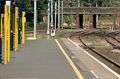 Northward view from the island platforms (Platforms 2 and 3). The points at the right are used by northbound terminating trains to access the southbound Platform 1 for the return trip.
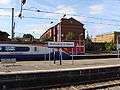
.jpg) Northbound Midland Mainline train, formed of Class 222 Meridian units, passing through Platform 4. East Midlands Trains services regularly pass through the station but do not stop.
Northbound Midland Mainline train, formed of Class 222 Meridian units, passing through Platform 4. East Midlands Trains services regularly pass through the station but do not stop.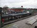 General view across the station, from the Victoria Street bridge
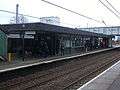 Buildings on the island platform
References
- ↑ Radford, B., (1983) Midland Line Memories: a Pictorial History of the Midland Railway Main Line Between London (St Pancras) & Derby London: Bloomsbury Books
- ↑ http://www.sigbox.co.uk
Sources
External links
| Wikimedia Commons has media related to St Albans City railway station. |
- Train times and station information for St Albans City railway station from National Rail