Watford Vicarage Road tube station
| Watford Vicarage Road | |
|---|---|
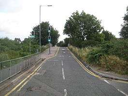 Vicarage Road railway bridge Looking northeast towards the hospital The site of the proposed station is on the left of the bridge | |
 Watford Vicarage Road Location of Watford Vicarage Road in Hertfordshire | |
| Location | Watford |
| Local authority | Watford |
| Managed by | London Underground |
| Number of platforms | 2 |
| London Underground annual entry and exit | |
| 2013 | Not Opened[1] |
| 2014 | Not Opened[1] |
| 2015 | Not Opened[1] |
| 2016 | Not Opened[1] |
| 2017 | Not Opened[1] |
| Other information | |
| Lists of stations | |
| WGS84 | 51°38′48″N 0°24′33″W / 51.646626°N 0.409284°WCoordinates: 51°38′48″N 0°24′33″W / 51.646626°N 0.409284°W |
|
| |
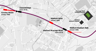
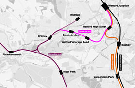
Watford Vicarage Road was a proposed London Underground station in Watford, Hertfordshire. The station would have been part of the Croxley Rail Link project, a scheme to extend the Metropolitan line to Watford Junction railway station, served by Metropolitan line trains between Watford Junction and Central London via Baker Street. Originally the station was to be named either Watford Hospital or Watford General Hospital.[2] On 25 January 2017, the Watford Observer newspaper published an update on the Croxley Rail Link confirming work had stopped as there was an ongoing funding issue.[3]
Site
Watford Vicarage Road was to have been a newly constructed station on a re-opened section of the former LNWR Watford and Rickmansworth Railway line which was closed by British Rail in 1996.[4] The station was to have been located to the west of Vicarage Road, adjacent to Holywell allotments, with the platforms in the railway cutting below the road. The single-storey glass and metal-clad station building is to be at street level, with staircases and lifts providing platform access.[5] Designs for the new station, and others on the link, have been prepared by Acanthus LW Architects.[6][7]
The new station was to have been between the sites of two former railway stations on the old LNWR line; to the west of the former Watford Stadium Halt and to the east of the former Watford West railway station (which was located to the west of the new station site, on Tolpits Lane).[2][8][9][10][11] It is not planned to re-open these disused stations and the platforms at both former stations will be removed or modified to accommodate the two new tracks.[12]
Name
The name originally proposed for the station was Watford Hospital, to reflect its proximity to Watford General Hospital. Local campaigners petitioned Transport for London (TfL) to name the station after Vicarage Road Stadium, home of Watford F.C., as they felt that it was a more easily recognised local landmark. TfL stated that their policy is not to name new stations after individual roads in order to ensure geographical understanding across the whole Tube network. However, in recognition of local opinion and the wider recognition of the Vicarage Road name in association with the football club, they agreed to waive this rule. On 8 August 2013 TfL announced that they would name the station Watford Vicarage Road.[13][14]
References
- 1 2 3 4 5 "Multi-year station entry-and-exit figures" (XLSX). London Underground station passenger usage data. Transport for London. January 2018. Retrieved 22 July 2018.
- 1 2 "TWAO Submission January 2012". Croxley Rail Link. 2012-01-06. Archived from the original on 2012-02-12.
- ↑ http://www.watfordobserver.co.uk/news/15047214.UPDATE__Met_Line_extension__Mayor_confirms_work_has_stopped/
- ↑ "Watford to Croxley Green". West Watford History Group. 2011. Archived from the original on 2013-08-07.
- ↑ "Croxley Rail Link Watford Vicarage Road Station - Report to Development Management Section Head" (PDF). Hertfordshire County Council. 21 January 2014. Archived (PDF) from the original on 10 January 2015. Retrieved 10 January 2015.
- ↑ "Croxley Rail Link Watford for Mouchel/Hertfordshire County Completion 2003". Retrieved 20 March 2012.
- ↑ Acanthus LW Architects - Infrastructure (Croxley Rail Link)(Page 10-11)
- ↑ "Major Scheme Business Case - Main Report" (PDF). Croxley Rail Link. 2009-10-30. Archived (PDF) from the original on 2012-03-09.
- ↑ "Croxley Rail Link". Croxley Rail Link. Archived from the original on 2010-11-02.
- ↑ "Major rail schemes included in £854m DfT investment". Railnews. 2011-12-14. Archived from the original on 2013-08-11.
- ↑ "Croxley Rail Link - Proposed Scheme Sheet 3 Proposed Watford Hospital Station" (PDF). Croxley Rail Link. November 2011. Archived (PDF) from the original on 2013-08-11.
- ↑ "Croxley Rail Link Project: Design & Access Statement" (PDF). Hertfordshire County Council. December 2011. Archived (PDF) from the original on 2013-08-11.
- ↑ "Vicarage Road approved by Transport for London for Croxley Rail Link's West Watford station name". Watford Observer. 2013-08-08. Archived from the original on 2013-08-09.
- ↑ "New Watford tube station to be called Vicarage Road". BBC News. BBC. 2013-08-09. Archived from the original on 2013-08-11.
External links
- "Planning Application Documents for Vicarage Road station". Planning & Environment. Watford Borough Council. Retrieved 10 January 2015.
- Croxley Rail Link project website
| Preceding station | Following station | |||
|---|---|---|---|---|
towards Watford Junction | Metropolitan line Croxley Rail Link |
Rail infrastructure projects in the United Kingdom | |||||||||||
|---|---|---|---|---|---|---|---|---|---|---|---|
| |||||||||||
| |||||||||||
| |||||||||||
| |||||||||||