List of Farm to Market Roads in Texas (2500–2599)
|
Texas Farm to Market Road and Ranch to Market Road markers | |
| Highway names | |
|---|---|
| Interstates | Interstate Highway X (IH-X, I-X) |
| US Highways | U.S. Highway X (US X) |
| State | State Highway X (SH X) |
| Loops: | Loop X |
| Spurs: | Spur X |
| Farm or Ranch to Market Roads: |
Farm to Market Road X (FM X) Ranch-to-Market Road X (RM X) |
| Park Roads: | Park Road X (PR X) |
| System links | |
Farm to Market Roads in Texas are owned and maintained by the Texas Department of Transportation (TxDOT).
FM 2500
| |
|---|---|
| Location | Polk County |
| Length | 6.215 mi[1] (10.002 km) |
| Existed | 1957[1]–present |
FM 2501
| |
|---|---|
| Location | Trinity County |
| Length | 6.104 mi[2] (9.823 km) |
| Existed | 1957[2]–present |
FM 2502
| |
|---|---|
| Location | Washington and Austin counties |
| Length | 19.137 mi[3] (30.798 km) |
| Existed | 1957[3]–present |
FM 2503
| |
|---|---|
| Location | Fayette County |
| Length | 6.134 mi[4] (9.872 km) |
| Existed | 1957[4]–present |
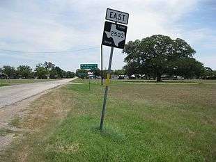
Farm to Market Road 2503 (FM 2503) is a state highway in the U.S. state of Texas that stays within Fayette County. The highway begins at State Highway 71 (SH 71) in Ellinger and goes northeast to end at an intersection with FM 1291 southeast of Fayetteville.
FM 2503 starts at a stop sign on SH 71 in Ellinger. At this point, SH 71 runs to the northwest and since FM 2503 meets it at right angles, the highway heads to the northeast. Hruska's Store and Bakery stands on the northwest side of FM 2503 at the intersection. In Ellinger, FM 2503 is also called Ross Street. After going eight blocks to the northwest the highway leaves Ellinger. At a distance of 2.2 miles (3.5 km) from its beginning, FM 2503 intersects with Saint Mary's Church Road coming from the southeast. From there to the junction with Brushy Road and Ross Prairie Church Road is another 1.9 miles (3.1 km). From Ross Prairie Church Road to the stop sign at FM 1291 is 2.1 miles (3.4 km). The junction is 2.6 miles (4.2 km) southeast of Fayetteville. FM 2503 is approximately parallel with FM 955, which is about 2 miles (3.2 km) to the northwest.[5]
FM 2503 was first designated on October 31, 1957, to start from SH 71 at Ellinger and head northeast for about 6.3 miles (10.1 km) to FM 1291. The route has not been altered since the original authorization.
- Junction list
The entire highway is in Fayette County.
| Location | mi | km | Destinations | Notes | |
|---|---|---|---|---|---|
| Ellinger | 0.0 | 0.0 | Southern terminus of FM 2503 | ||
| | 2.2 | 3.5 | St. Mary's Church Road | ||
| | 4.1 | 6.6 | Ross Prairie Church Road | ||
| | 6.1 | 9.8 | Northern terminus of FM 2503 | ||
| 1.000 mi = 1.609 km; 1.000 km = 0.621 mi | |||||
FM 2504
| |
|---|---|
| Location | Atascosa County |
| Length | 9.592 mi[6] (15.437 km) |
| Existed | 1957[6]–present |
FM 2505
| |
|---|---|
| Location | Wilson County |
| Length | 14.93 mi[7] (24.03 km) |
| Existed | 1957[7]–present |
FM 2506
| |
|---|---|
| Location | Goliad County |
| Length | 6.103 mi[8] (9.822 km) |
| Existed | 1957[8]–present |
FM 2507
| |
|---|---|
| Location | Jim Wells County |
| Length | 1.039 mi[9] (1.672 km) |
| Existed | 1957[9]–present |
FM 2508
| |
|---|---|
| Location | Jim Wells County |
| Length | 5.849 mi[10] (9.413 km) |
| Existed | 1957[10]–present |
FM 2509
| |
|---|---|
| Location | Karnes County |
| Length | 5.657 mi[11] (9.104 km) |
| Existed | 1957[11]–present |
FM 2510
| |
|---|---|
| Location | Kleberg County |
| Length | 1.964 mi[12] (3.161 km) |
| Existed | 1957[12]–present |
FM 2511
| |
|---|---|
| Location | Refugio County |
| Length | 2.001 mi[13] (3.220 km) |
| Existed | 1957[13]–present |
FM 2512
| |
|---|---|
| Location | San Patricio County |
| Length | 2.012 mi[14] (3.238 km) |
| Existed | 1957[14]–present |
FM 2513
| |
|---|---|
| Location | Brazos County |
| Existed | October 31, 1957–December 14, 1989[15] |
Farm to Market Road 2513 (FM 2513) is a former highway that was located in Brazos County. No highway currently uses the FM 2513 designation.
FM 2513 was designated on October 31, 1957, traveling from the intersection of Carson Street and Turkey Creek Road in Bryan southward to FM 60 west of College Station at a distance of 3.6 miles (5.8 km). The section of highway between FM 2818 and FM 60 was transferred to FM 2818 on October 8, 1965, decreasing the route's length by 2.6 miles (4.2 km).[16] FM 2513 was cancelled and removed from the state highway system on December 14, 1989, with maintenance being turned over to the city of Bryan.
FM 2514
| |
|---|---|
| Location | Collin County |
| Length | 8.632 mi[17] (13.892 km) |
| Existed | September 27, 1960[17]–present |
FM 2514 (1957)
| |
|---|---|
| Location | Robertson County |
| Existed | October 31, 1957–December 30, 1959 |
FM 2515
| |
|---|---|
| Location | Kaufman County |
| Length | 2.529 mi[18] (4.070 km) |
| Existed | 1957[18]–present |
FM 2516
| |
|---|---|
| Location | Bowie County |
| Length | 6.543 mi[19] (10.530 km) |
| Existed | 1957[19]–present |
FM 2517
| |
|---|---|
| Location | Panola County |
| Length | 20.201 mi[20] (32.510 km) |
| Existed | 1957[20]–present |
FM 2518
| |
|---|---|
| Location | Liberty County |
| Length | 5.437 mi[21] (8.750 km) |
| Existed | 1957[21]–present |
FM 2519
| |
|---|---|
| Location | Cameron County |
| Length | 1.693 mi[22] (2.725 km) |
| Existed | 1957[22]–present |
Farm to Market Road 2519 (FM 2519) is a 1.693-mile (2.725 km) farm to market road in Brownsville.
FM 2519 begins at SH 4 in central Brownsville. It travels to the south and east along Billy Mitchell Boulevard before state maintenance ends at the entrance to Brownsville/South Padre Island International Airport.[22][23]
FM 2519 was designated on October 31, 1957 along its current route.[22] On June 27, 1995, the official designation was changed to Urban Road 2519 (UR 2519); however, as with other urban roads, TxDOT still signs the route using the standard Farm Road marker.[24]
- Junction list
The entire route is in Brownsville, Cameron County.
| mi[25] | km | Destinations | Notes | ||
|---|---|---|---|---|---|
| 0.0 | 0.0 | Western terminus | |||
| 0.9 | 1.4 | Brownsville/South Padre Island International Airport | Eastern terminus | ||
| 1.000 mi = 1.609 km; 1.000 km = 0.621 mi | |||||
FM 2520
| |
|---|---|
| Location | Cameron County |
| Length | 7.079 mi[26] (11.393 km) |
| Existed | 1957[26]–present |
FM 2521
| |
|---|---|
| Location | Hidalgo County |
| Length | 1.073 mi[27] (1.727 km) |
| Existed | 1957[27]–present |
FM 2522
| |
|---|---|
| Location | Dimmit County |
| Length | 4.953 mi[28] (7.971 km) |
| Existed | 1957[28]–present |
RM 2523
| |
|---|---|
| Location | Val Verde, Kinney and Edwards counties |
| Length | 40.459 mi[29] (65.112 km) |
| Existed | 1957[29]–present |
Ranch to Market Road 2523 (RM 2523') is located in Val Verde, Kinney and Edwards counties.
RM 2523 begins at an intersection with US 90 in eastern Del Rio. Just north of the intersection with US 90, the highway travels through Val Verde Park and leaves the town right before an intersection with Loop 79. Outside of the Del Rio area, RM 2523 travels through largely rural areas, with the terrain becoming more hilly the further north the highway travels. RM 2523 ends at an intersection with US 377 northeast of Carta Valley.
RM 2523 was designated on October 31, 1957, traveling from US 90 northeastward at a distance of 5.5 miles (8.9 km). The highway was extended 18.0 miles (29.0 km) northeastward on October 31, 1958. RM 2523 was extended 6.6 miles (10.6 km) northeastward on November 24, 1959. The highway was extended 4.0 miles (6.4 km) northward on September 27, 1960. RM 2523 was extended 6.5 miles (10.5 km) to US 377 on June 20, 1961.
- Junction list
| County | Location | mi[30] | km | Destinations | Notes |
|---|---|---|---|---|---|
| Val Verde | Del Rio | 0.0 | 0.0 | ||
| | 2.1 | 3.4 | |||
| Kinney | | 18.8 | 30.3 | ||
| Edwards | | 40.5 | 65.2 | ||
| 1.000 mi = 1.609 km; 1.000 km = 0.621 mi | |||||
FM 2524
| |
|---|---|
| Location | Brown County |
| Length | 5.442 mi[31] (8.758 km) |
| Existed | 1957[31]–present |
FM 2525
| |
|---|---|
| Location | Brown County |
| Length | 6.885 mi[32] (11.080 km) |
| Existed | 1957[32]–present |
FM 2526
| |
|---|---|
| Location | Eastland County |
| Length | 21.193 mi[33][nb 1] (34.107 km) |
| Existed | 1957[33]–present |
Farm to Market Road 2526 (FM 2526) is located entirely in Eastland County.
FM 2526 begins at an intersection with FM 569 at Nimrod. The highway travels in an eastern direction and intersects SH 206 and has a brief overlap with US 183. After the overlap, FM 2526 continues to travel in an eastern direction and enters the town of Carbon, where it intersects SH 6. The highway ends at an intersection with FM 2689.
FM 2526 was designated on October 31, 1957, running from US 183 near Pleasant Hill eastward to SH 6 (now Loop 389) at Carbon, at a distance of 8.7 miles (14.0 km). The highway was extended 5.3 miles (8.5 km) westward to FM 569 on October 31, 1958. FM 2526 was extended 7.6 miles (12.2 km) eastward to FM 2689 on May 6, 1964.
- Junction list
The entire route is in Eastland County.
| Location | mi[34] | km | Destinations | Notes | |
|---|---|---|---|---|---|
| Nimrod | 0.0 | 0.0 | |||
| | 2.2 | 3.5 | |||
| | 5.3 | 8.5 | West end of US 183 overlap | ||
| | 5.8 | 9.3 | East end of US 183 overlap | ||
| Carbon | 13.9 | 22.4 | |||
| 14.2 | 22.9 | ||||
| | 21.7 | 34.9 | |||
1.000 mi = 1.609 km; 1.000 km = 0.621 mi
| |||||
FM 2527
| |
|---|---|
| Location | Lampasas County |
| Length | 5.857 mi[35] (9.426 km) |
| Existed | 1957[35]–present |
Farm to Market Road 2527 (FM 2527) is located entirely in Lampasas County.
FM 2527 begins at an intersection with FM 580 near Rumley. The highway runs in a slight northwest direction and runs parallel to the Lampasas River for its entire route. FM 2527 ends at an intersection with FM 1690.
FM 2527 was designated on October 31, 1957, running from FM 580 northwestward at a distance of 4.0 miles (6.4 km). The highway was extended to FM 1690 on October 31, 1958.
- Junction list
The entire route is in Lampasas County.
| Location | mi[35] | km | Destinations | Notes | |
|---|---|---|---|---|---|
| | 0.000 | 0.000 | |||
| | 5.857 | 9.426 | |||
| 1.000 mi = 1.609 km; 1.000 km = 0.621 mi | |||||
FM 2528
| |
|---|---|
| Location | Lubbock and Lamb counties |
| Length | 20.006 mi[36][nb 2] (32.197 km) |
| Existed | 1958[36]–present |
Farm to Market Road 2528 (FM 2528) is a farm to market road located in the Lubbock metropolitan area. The section of FM 2528 from Loop 289 to U.S. Highway 84 (US 84) is internally designated as Urban Road 2528 by the Texas Department of Transportation (TxDOT).
FM 2528 begins at Loop 289 in west Lubbock. The highway runs north along Frankford Avenue and has an intersection with FM 2255 (4th Street) near a major retail center. Development along the highway begins to lower after an intersection with Erskine Street before leaving the city limits of Lubbock. Shortly after leaving Lubbock, FM 2528 has an intersection with US 84 and FM 2641 shortly after that. The highway travels through sparsely populated areas of Lubbock County and overlaps with FM 597 between Anton and Abernathy. After leaving FM 597, FM 2528 enters Lamb County and ends at an intersection with FM 54 southeast of Spade.[37]
FM 2528 was first designated on October 31, 1958, from FM 597 south to FM 1729 west of New Deal. On June 28, 1963, the highway was extended south to Loop 289 in Lubbock. On November 5, 1971, FM 2528 was extended north to FM 54, overlapping with FM 597 in the process.[38] On June 27, 1995, the highway was internally designated as Urban Road 2528 by TxDOT from Loop 289 to US 84.[39]
- Junction list
| County | Location | mi[37] | km | Destinations | Notes |
|---|---|---|---|---|---|
| Lubbock | Lubbock | 0.0 | 0.0 | Interchange | |
| 0.4 | 0.64 | ||||
| | 4.0 | 6.4 | Interchange | ||
| | 4.4 | 7.1 | |||
| | 7.5 | 12.1 | |||
| | 10.5 | 16.9 | |||
| | 16.5 | 26.6 | South end of FM 597 overlap | ||
| | 17.5 | 28.2 | North end of FM 597 overlap | ||
| Lamb | | 21.1 | 34.0 | ||
1.000 mi = 1.609 km; 1.000 km = 0.621 mi
| |||||
RM 2528
| |
|---|---|
| Location | Hudspeth County |
| Existed | October 31, 1957–December 6, 1957 |
RM 2528 was designated on October 31, 1957, from US 80 (now I-10) at Sierra Blanca south to a road intersection. This was cancelled on December 6, 1957, and mileage was transferred to RM 1111.[40]
FM 2529
| |
|---|---|
| Location | El Paso County |
| Length | 7.855 mi[41] (12.641 km) |
| Existed | 1957[41]–present |
Farm to Market Road 2529 (FM 2529) is located entirely in El Paso County within the city of El Paso.
FM 2529 begins at an intersection with Bus. US 54 (Dyer Street) near Fort Bliss. The highway travels in a northern direction along McCombs Street through an area of the city with a mix of residential and commercial development. North of US 54, FM 2529 travels through more rural areas of the city's northside. The highway turns west onto Stan Roberts Sr. Avenue, running one mile south of the New Mexico state line, before ending at an intersection with FM 3255 (Martin Luther King Jr. Boulevard).
FM 2529 was designated on October 31, 1957, traveling from US 54 (now Bus. US 54) northward to the El Paso Natural Gas Company compressor station at a distance of 6.6 miles (10.6 km). The highway was extended 2.0 miles (3.2 km) westward to Dona Ana Target Range Road on October 31, 1958. The section of FM 2529 between FM 2637 and FM 3255 was relocated on November 29, 1982 (the old route is now State Line Drive). The entire highway was internally re-designated as Urban Road 2529 by TxDOT on June 27, 1995. [42]
- Junction list
The entire route is in El Paso, El Paso County.
| mi[43] | km | Destinations | Notes | ||
|---|---|---|---|---|---|
| 0.0 | 0.0 | ||||
| 2.6 | 4.2 | ||||
| 5.0 | 8.0 | ||||
| 7.9 | 12.7 | ||||
| 1.000 mi = 1.609 km; 1.000 km = 0.621 mi | |||||
FM 2530
| |
|---|---|
| Location | Childress County |
| Length | 7.687 mi[44] (12.371 km) |
| Existed | 1957[44]–present |
FM 2531
| |
|---|---|
| Location | Collingsworth County |
| Length | 2.71 mi[45] (4.36 km) |
| Existed | 1957[45]–present |
FM 2532
| |
|---|---|
| Location | Cottle County |
| Length | 7.619 mi[46] (12.262 km) |
| Existed | 1957[46]–present |
FM 2533
| |
|---|---|
| Location | Hardeman County |
| Length | 5.415 mi[47] (8.715 km) |
| Existed | 1957[47]–present |
FM 2534
| |
|---|---|
| Location | Knox County |
| Length | 17.629 mi[48] (28.371 km) |
| Existed | 1957[48]–present |
FM 2535
| |
|---|---|
| Location | Hansford County |
| Length | 13.266 mi[49] (21.350 km) |
| Existed | September 20, 1961[49]–present |
FM 2535 (1957)
| |
|---|---|
| Location | Clay County |
| Existed | October 31, 1957–October 30, 1960 |
FM 2536
| |
|---|---|
| Location | Bexar County |
| Length | 6.742 mi[50] (10.850 km) |
| Existed | 1958[50]–present |
Farm to Market Road 2536 (FM 2536) is located entirely in Bexar County.
FM 2536 begins at an intersection with Loop 1604 southwest of San Antonio. The highway travels in a northeast direction through more rural areas of the county and enters San Antonio near an intersection with Nelson Road. FM 2536 continues to travel through less developed areas and runs near a large residential area of the city after a junction with I-410 / SH 16. The highway travels along the edge of Pearsall Park before ending at an intersection with Loop 13 near Lackland AFB. FM 2536 in San Antonio is known locally as Old Pearsall Road.
FM 2536 was designated on April 24, 1958, traveling from Loop 13 southwestward to FM 2173 (which has since been discontinued). The highway's northern terminus was re-located to I-410 on July 26, 1960, with the southern terminus being re-located to a point 2.6 miles (4.2 km) southwest of I-410; FM 2536 was restored to its previous routing two months later on September 26. The highway was extended to FM 1604 (now Loop 1604) on November 3, 1972 (FM 2173 became part of Loop 1604 around that time). The section of FM 2536 between I-410 and Loop 13 was internally re-designated as Urban Road 2536 by TxDOT on June 27, 1995.[51]
- Junction list
The entire route is in Bexar County.
| Location | mi[52] | km | Destinations | Notes | |
|---|---|---|---|---|---|
| | 0.0 | 0.0 | |||
| San Antonio | 3.9 | 6.3 | I-410 exit 2 | ||
| 6.7 | 10.8 | ||||
| 1.000 mi = 1.609 km; 1.000 km = 0.621 mi | |||||
FM 2537
| |
|---|---|
| Location | Bexar County |
| Length | 1.508 mi[53] (2.427 km) |
| Existed | 1958[53]–present |
Farm to Market Road 2537 (FM 2537) is located entirely in Bexar County.
FM 2537 begins at an intersection with Pleasanton Road south of San Antonio. The highway travels in a southeast direction through rural farm areas before ending at an intersection with US 281 near Southside High School.
FM 2537 was designated on April 24, 1958 along the current route.
- Junction list
The entire route is in Bexar County.
| Location | mi[53] | km | Destinations | Notes | |
|---|---|---|---|---|---|
| | 0.000 | 0.000 | Pleasanton Road | ||
| | 1.508 | 2.427 | |||
| 1.000 mi = 1.609 km; 1.000 km = 0.621 mi | |||||
FM 2538
| |
|---|---|
| Location | Bexar and Guadalupe counties |
| Length | 7.862 mi[54] (12.653 km) |
| Existed | 1958[54]–present |
Farm to Market Road 2538 (FM 2538) is located in Bexar and Guadalupe counties.
FM 2538 begins at a junction with I-10 / US 90 / SH 130 near Zuehl. The highway travels in a southeast direction near Cibolo Creek and the Zuehl city limits until an intersection with Real Rock Road, running near several farms and guest ranches. FM 2538 crosses the creek and enters New Berlin, where it ends at an intersection with FM 775.
FM 2538 was designated on April 24, 1958, running from US 90 0.7 miles (1.1 km) west of the Bexar-Guadalupe county line southeastward to Cibolo Creek at a distance of 6.7 miles (10.8 km). The highway was extended 1.6 miles (2.6 km) from Cibolo Creek to FM 775 later that year on October 31.
- Junction list
| County | Location | mi[54] | km | Destinations | Notes |
|---|---|---|---|---|---|
| Bexar | | 0.000 | 0.000 | I-10 exit 593 | |
| Guadalupe | New Berlin | 7.862 | 12.653 | ||
| 1.000 mi = 1.609 km; 1.000 km = 0.621 mi | |||||
FM 2539
| |
|---|---|
| Location | Leon County |
| Length | 1.963 mi[55] (3.159 km) |
| Existed | 1957[55]–present |
FM 2540
| |
|---|---|
| Location | Matagorda County |
| Length | 11.802 mi[56] (18.993 km) |
| Existed | 1958[56]–present |
FM 2541
| |
|---|---|
| Location | Calhoun County |
| Length | 4.628 mi[57] (7.448 km) |
| Existed | June 28, 1963[57]–present |
FM 2541 (1958)
| |
|---|---|
| Location | Matagorda County |
| Existed | October 31, 1958–May 29, 1962 |
FM 2542
| |
|---|---|
| Location | DeWitt County |
| Length | 4.958 mi[58] (7.979 km) |
| Existed | 1958[58]–present |
FM 2543
| |
|---|---|
| Location | Lavaca County |
| Length | 3.187 mi[59] (5.129 km) |
| Existed | 1958[59]–present |
FM 2544
| |
|---|---|
| Location | Houston County |
| Length | 3.475 mi[60] (5.592 km) |
| Existed | January 25, 1962[60]–present |
FM 2544 (1958)
| |
|---|---|
| Location | Calhoun County |
| Existed | October 31, 1958–September 20, 1961 |
FM 2545
Farm to Market Road 2545 (FM 2545) is a designation that has been used three times. No highway currently uses the FM 2545 designation.
FM 2545 (1958)
| |
|---|---|
| Location | Victoria County |
| Existed | October 31, 1958–May 25, 1962 |
FM 2545 (1963)
| |
|---|---|
| Location | Houston County |
| Existed | January 30, 1963–October 14, 1964 |
FM 2545 (1965)
| |
|---|---|
| Location | Tarrant County |
| Existed | June 1, 1965–November 26, 1969 |
RM 2545
| |
|---|---|
| Location | Llano County |
| Length | 3.037 mi[61] (4.888 km) |
| Existed | May 7, 1970[61]–present |
FM 2546
| |
|---|---|
| Location | Wharton County |
| Length | 13.051 mi[62] (21.004 km) |
| Existed | 1958[62]–present |
Farm to Market Road 2546 (FM 2546) is a state highway in the U.S. state of Texas that stays within Wharton County. The two-lane road starts at Mount Pilgrim Baptist Church and goes directly west past FM 1160 and State Highway 71 (SH 71). East of SH 71, the highway turns sharply to the southwest and ends at SH 71 north of El Campo.
FM 2546 starts at a rural intersection in front of Mount Pilgrim Baptist Church. The paved highway ends at this location. From here, gravel-topped County Road 394 continues west and another gravel road goes north. From the church east to FM 1160 at the site of Hahn is 3.3 miles (5.3 km). The distance from FM 1160 eastward to SH 71 is 4.2 miles (6.8 km). The Hahn Cemetery is on the south side of the road along this stretch of FM 2546. Continuing east of SH 71, the highway passes through the tiny community of Jones Creek. At a distance of 2.3 miles (3.7 km) east of SH 71, FM 2546 turns sharply to the southwest. After going southwest an additional 2.3 miles (3.7 km) the highway comes to the intersection with FM 2765. Continuing to the southwest for 1.0 mile (1.6 km), FM 2546 ends at a stop sign on SH 71. The continuation of the road on the west side of SH 71 is called Sandy Corners Road.[63]
FM 2546 was originally designated on October 31, 1958 to start at FM 1160 and run approximately 4.3 miles (6.9 km) eastward to a point on SH 71 which was 1.7 miles (2.7 km) southeast of New Taiton in Wharton County. On May 2, 1962 the highway was extended west from FM 1160 about 3.5 miles (5.6 km), making a total distance of approximately 7.7 miles (12.4 km). On May 5, 1966, FM 2546 was extended east from SH 71 a distance of about 2.4 miles (3.9 km). From this point, the highway followed 3.3 miles (5.3 km) of the former right-of-way of FM 2923 to end at SH 71 at a location 2.2 miles (3.5 km) north of the El Campo city limit.[62] FM 2923 was canceled on May 18, 1966.[64]
 Mt Pilgrim Baptist Church is at the western end of FM 2546 where the pavement ends.
 FM 1160 and FM 2546 meet at the site of Hahn.
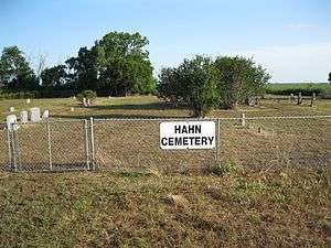 Hahn Cemetery is on FM 2546 east of FM 1160.
- Junction list
The entire highway is in Wharton County.
| Location | mi | km | Destinations | Notes | |
|---|---|---|---|---|---|
| Pin Oak | 0.0 | 0.0 | County Road 394 | Western terminus of FM 2546 | |
| Hahn | 3.3 | 5.3 | |||
| | 7.5 | 12.1 | |||
| | 12.1 | 19.5 | Northern terminus of FM 2765 | ||
| | 13.1 | 21.1 | Eastern terminus of FM 2546 | ||
| 1.000 mi = 1.609 km; 1.000 km = 0.621 mi | |||||
FM 2547
| |
|---|---|
| Location | Freestone County |
| Length | 5.368 mi[65] (8.639 km) |
| Existed | 1958[65]–present |
FM 2548
| |
|---|---|
| Location | Madison County |
| Length | 6.676 mi[66] (10.744 km) |
| Existed | 1958[66]–present |
FM 2549
| |
|---|---|
| Location | Robertson County |
| Length | 11.742 mi[67] (18.897 km) |
| Existed | 1958[67]–present |
FM 2550
| |
|---|---|
| Location | Walker County |
| Length | 4.334 mi[68] (6.975 km) |
| Existed | 1958[68]–present |
FM 2551
| |
|---|---|
| Location | Collin County |
| Length | 6.616 mi[69] (10.647 km) |
| Existed | 1958[69]–present |
Farm to Market Road 2551 (FM 2551) is a Farm to Market Road in Collin County in the US state of Texas.
FM 2551 begins at FM 544 in Murphy. It travels north along Murphy Road into Parker, where it intersects FM 2514. The two routes are briefly concurrent along Parker Road before FM 2551 turns to the north along Dillehay Drive. The route enters Allen, where it is known as Angel Parkway, before ending at FM 2170 near the Lucas city limits.
FM 2551 was designated on December 16, 1958, traveling from FM 2170 east of Allen southward to a road intersection near Parker at a distance of 3.2 miles (5.1 km). The highway was extended 3.5 miles (5.6 km) to FM 544 in Murphy on June 25, 1962. All of FM 2551 was internally re-designated as Urban Road 2551 by TxDOT on June 27, 1995.[70]
- Junction list
The entire route is in Collin County.
| Location | mi[71] | km | Destinations | Notes | |
|---|---|---|---|---|---|
| Murphy | 0.0 | 0.0 | |||
| Parker | 3.0 | 4.8 | South end of FM 2514 overlap | ||
| 3.4 | 5.5 | North end of FM 2514 overlap | |||
| Allen | 6.6 | 10.6 | |||
| 1.000 mi = 1.609 km; 1.000 km = 0.621 mi | |||||
FM 2552
| |
|---|---|
| Location | Parker County |
| Length | 2.712 mi[72] (4.365 km) |
| Existed | February 29, 1968[72]–present |
Farm to Market Road 2552 (FM 2552) is located entirely in Parker County in Weatherford.
FM 2552 begins at a junction with I-20 and Clear Lake Road. The highway travels briefly along Clear Lake Road before traveling along Santa Fe Drive in a northwestern direction before turning west near Briarhaven Boulevard, then turns north near Park Avenue. FM 2552 turns off of Santa Fe Drive onto Jack Borden Way at an intersection. The highway travels along Jack Borden Way through the Town Creek greenbelt before ending at an intersection with US 180.
The current FM 2552 was designated on February 29, 1968, traveling from US 80 (now US 180) southeastward to I-20. The highway was re-routed onto to Jack Borden Way near the town square in 2016 as part of the city's plan to alleviate vehicle traffic in the area.[73][74]
- Junction list
The entire route is in Weatherford, Parker County.
| mi[72] | km | Destinations | Notes | ||
|---|---|---|---|---|---|
| 0.000 | 0.000 | I-20 exit 409 | |||
| 2.712 | 4.365 | ||||
| 1.000 mi = 1.609 km; 1.000 km = 0.621 mi | |||||
FM 2552 (1958)
| |
|---|---|
| Location | Bowie County |
| Existed | October 31, 1958–October 3, 1966 |
FM 2552 was originally designated on October 31, 1958, running from US 82 west of New Boston southward to SH 98 at a distance of 3.0 miles (4.8 km). The highway was cancelled on October 3, 1966 when SH 98 was rerouted.[75]
FM 2553
| |
|---|---|
| Location | Harris County |
| Length | 1.152 mi[76] (1.854 km) |
| Existed | July 29, 1965[76]–present |
Farm to Market Road 2553 (FM 2553) is located entirely in Harris County in southeastern Houston.
FM 2553 begins at I-45 near the Sam Houston Tollway. The highway travels in a northeastern direction as a mostly two-lane undivided highway along Scarsdale Road. FM 2553 travels through a rural, undeveloped area of the city, before traveling near a subdivision and ending at an intersection with SH 3.
The current FM 2553 was designated on July 29, 1965, running from I-45 northeastward to SH 3. The entire highway was internally re-designated as Urban Road 2553 by TxDOT on June 27, 1995.[77]
- Junction list
The entire route is in Houston, Harris County.
| mi[76] | km | Destinations | Notes | ||
|---|---|---|---|---|---|
| 0.000 | 0.000 | I-45 exit 31 | |||
| 1.152 | 1.854 | ||||
| 1.000 mi = 1.609 km; 1.000 km = 0.621 mi | |||||
FM 2553 (1958)
| |
|---|---|
| Location | Bowie County |
| Existed | October 31, 1958–June 10, 1965 |
The original FM 2553 was designated on October 31, 1958, running from FM 1840 near DeKalb southeastward to a road intersection at a distance of 6.7 miles (10.8 km). The highway was cancelled and combined with FM 990 on June 10, 1965.[78]
FM 2554
| |
|---|---|
| Location | Fannin County |
| Length | 7.123 mi[79] (11.463 km) |
| Existed | 1958[79]–present |
FM 2555
| |
|---|---|
| Location | Navarro County |
| Length | 5.228 mi[80] (8.414 km) |
| Existed | September 27, 1960[80]–present |
Farm to Market Road 2555 (FM 2555) is located entirely in Navarro County.
FM 2555 begins at an intersection with FM 709 in the town of Retreat. The highway travels in a northwestern direction, then turns in a more northern direction at Oak Valley. FM 2555 enters Corsicana near an intersection with Oak Valley Road then intersects SH 31 near a commercial area. The highway intersects FM 744 near Corsicana High School before ending at an intersection with SH 22. The section of FM 2555 within Corsicana is known locally as 45th Street.
The current FM 2555 was designated in 1960, running from SH 31 northwestward to SH 22 at a distance of 1.7 miles (2.7 km). The highway was extended 3.4 miles (5.5 km) southward to FM 709 in 1981.
- Junction list
The entire route is in Navarro County.
| Location | mi[81] | km | Destinations | Notes | |
|---|---|---|---|---|---|
| Retreat | 0.0 | 0.0 | |||
| Corsicana | 3.6 | 5.8 | |||
| 5.0 | 8.0 | ||||
| 5.2 | 8.4 | ||||
| 1.000 mi = 1.609 km; 1.000 km = 0.621 mi | |||||
FM 2555 (1958)
| |
|---|---|
| Location | Liberty County |
| Existed | October 31, 1958–December 18, 1959 |
The original FM 2555 was designated in 1958, running from SH 146 northeast of Liberty, northward to a county road at a distance of 5.3 miles (8.5 km). The highway was cancelled in 1959, with the mileage being transferred to FM 1011.[82]
FM 2556
| |
|---|---|
| Location | Cameron County |
| Length | 16.94 mi[83] (27.26 km) |
| Existed | 1958[83]–present |
FM 2557
| |
|---|---|
| Location | Hidalgo County |
| Length | 7.347 mi[84] (11.824 km) |
| Existed | October 18, 1967[84]–present |
FM 2557 (1958)
| |
|---|---|
| Location | Zavala County |
| Existed | October 31, 1958–June 21, 1967 |
FM 2558
| |
|---|---|
| Location | San Augustine County |
| Length | 3.25 mi[85] (5.23 km) |
| Existed | February 22, 1961[85]–present |
FM 2558 (1958)
| |
|---|---|
| Location | Dimmit County |
| Existed | October 31, 1958–January 31, 1961 |
FM 2559
| |
|---|---|
| Location | Brown County |
| Length | 4.977 mi[86] (8.010 km) |
| Existed | 1958[86]–present |
FM 2560
| |
|---|---|
| Location | Hopkins County |
| Length | 5.359 mi[87] (8.624 km) |
| Existed | June 28, 1963[87]–present |
FM 2560 (1958)
| |
|---|---|
| Location | Coleman County |
| Existed | October 31, 1958–May 24, 1962 |
FM 2561
| |
|---|---|
| Location | Comanche County |
| Length | 8.637 mi[88] (13.900 km) |
| Existed | 1958[88]–present |
FM 2562
| |
|---|---|
| Location | Grimes County |
| Length | 6.727 mi[89] (10.826 km) |
| Existed | May 7, 1970[89]–present |
FM 2562 (1958)
| |
|---|---|
| Location | Childress County |
| Existed | October 31, 1958–February 20, 1970 |
FM 2563
| |
|---|---|
| Location | Eastland County |
| Length | 10.366 mi[90] (16.682 km) |
| Existed | 1958[90]–present |
FM 2564
| |
|---|---|
| Location | Cottle County |
| Length | 2.049 mi[91] (3.298 km) |
| Existed | 1958[91]–present |
FM 2565
| |
|---|---|
| Location | Dickens County |
| Length | 4.583 mi[92] (7.376 km) |
| Existed | 1958[92]–present |
FM 2566
| |
|---|---|
| Location | Foard County |
| Length | 4.034 mi[93] (6.492 km) |
| Existed | 1958[93]–present |
FM 2567
| |
|---|---|
| Location | Castro County |
| Length | 5.074 mi[94] (8.166 km) |
| Existed | May 2, 1962[94]–present |
FM 2567 (1958)
| |
|---|---|
| Location | Hardeman County |
| Existed | October 31, 1958–October 9, 1961 |
FM 2568
| |
|---|---|
| Location | Hardeman County |
| Length | 7.043 mi[95] (11.335 km) |
| Existed | 1958[95]–present |
FM 2569
| |
|---|---|
| Location | King County |
| Length | 1.764 mi[96] (2.839 km) |
| Existed | 1958[96]–present |
FM 2570
| |
|---|---|
| Location | Freestone County |
| Length | 8.004 mi[97] (12.881 km) |
| Existed | April 1, 1968[97]–present |
FM 2570 (1958)
| |
|---|---|
| Location | Knox County |
| Existed | October 31, 1958–June 21, 1967 |
FM 2571
| |
|---|---|
| Location | Bastrop County |
| Length | 9.641 mi[98] (15.516 km) |
| Existed | September 27, 1960[98]–present |
RM 2571
| |
|---|---|
| Location | Gray County |
| Existed | October 31, 1958–December 11, 1959 |
FM 2572
| |
|---|---|
| Location | Shelby County |
| Length | 1.659 mi[99] (2.670 km) |
| Existed | January 31, 1969[99]–present |
FM 2572 (1958)
| |
|---|---|
| Location | Waller County |
| Existed | October 31, 1958–September 11, 1968 |
FM 2573
| |
|---|---|
| Location | Red River County |
| Length | 8.715 mi[100] (14.025 km) |
| Existed | 1958[100]–present |
FM 2574
| |
|---|---|
| Location | Anderson County |
| Length | 5.25 mi[101] (8.45 km) |
| Existed | 1958[101]–present |
FM 2575
| |
|---|---|
| Location | Potter and Carson counties |
| Length | 3.208 mi[102] (5.163 km) |
| Existed | 1958[102]–present |
FM 2576
| |
|---|---|
| Location | Crosby County |
| Length | 5.21 mi[103] (8.38 km) |
| Existed | May 2, 1962[103]–present |
Farm to Market Road 2576 (FM 2576) is a farm-to-market road in Crosby County, Texas.
The southern terminus of FM 2576 is at an intersection with FM 40 near the unincorporated community of Savage. The northern terminus is 5.210 miles (8.385 km) to the north, at an intersection with US 62 / US 82 / SH 114 west of Ralls.[103][104]
The current designation was established on May 2, 1962.
- Junction list
The entire route is in Crosby County.
| Location | mi[105] | km | Destinations | Notes | |
|---|---|---|---|---|---|
| Savage | 0.0 | 0.0 | Southern terminus | ||
| | 5.2 | 8.4 | Northern terminus | ||
| 1.000 mi = 1.609 km; 1.000 km = 0.621 mi | |||||
FM 2576 (1958)
| |
|---|---|
| Location | Jasper County |
| Existed | December 19, 1958–October 16, 1961 |
A previous route designed FM 2576 was designated in Jasper County on December 19, 1958, southward 3.5 miles from an intersection with FM 105. On nOvember 24, 1959, the route was extended southward 2.4 miles. This route became a part of FM 1131 on October 16, 1961.[106]
FM 2577
| |
|---|---|
| Location | Hartley County |
| Length | 6.894 mi[107] (11.095 km) |
| Existed | 1958[107]–present |
FM 2578
| |
|---|---|
| Location | Kaufman County |
| Existed | 1959[102]–present |
FM 2579
| |
|---|---|
| Location | Wilson County |
| Length | 8.531 mi[108] (13.729 km) |
| Existed | 1958[108]–present |
FM 2580
| |
|---|---|
| Location | Parker and Hood counties |
| Length | 10.343 mi[109] (16.645 km) |
| Existed | 1959[109]–present |
FM 2581
| |
|---|---|
| Location | Archer County |
| Length | 11.118 mi[110] (17.893 km) |
| Existed | 1959[110]–present |
FM 2582
| |
|---|---|
| Location | Baylor County |
| Length | 3.865 mi[111] (6.220 km) |
| Existed | 1959[111]–present |
FM 2583
| |
|---|---|
| Location | Montague County |
| Length | 3.588 mi[112] (5.774 km) |
| Existed | 1959[112]–present |
FM 2584
| |
|---|---|
| Location | Throckmorton County |
| Length | 2.081 mi[113] (3.349 km) |
| Existed | 1959[112]–present |
FM 2585
| |
|---|---|
| Location | Wilbarger County |
| Length | 6.246 mi[114] (10.052 km) |
| Existed | 1959[114]–present |
FM 2586
| |
|---|---|
| Location | Dallam County |
| Length | 7.782 mi[115] (12.524 km) |
| Existed | 1959[115]–present |
FM 2587
| |
|---|---|
| Location | Deaf Smith County |
| Length | 25.766 mi[116] (41.466 km) |
| Existed | 1959[116]–present |
FM 2588
| |
|---|---|
| Location | Lipscomb County |
| Existed | November 24, 1959–December 5, 1960 |
Farm to Market Road 2588 (FM 2588) was previously designated to a route in Lipscomb County. No highway currently uses the FM 2588 designation.
FM 2588 was designated on November 24, 1959, traveling from SH 305 near Lipscomb, westward at a distance of 3.5 miles (5.6 km). The highway was cancelled in 1960, with the mileage being transferred to FM 1920.[117]
RM 2588
| |
|---|---|
| Location | Henderson County |
| Length | 4.306 mi[118] (6.930 km) |
| Existed | January 12, 1961[118]–present |
Ranch to Market Road 2588 (RM 2588) is a ranch to market road in Henderson County, Texas.
State maintenance and the RM 2588 designation begins in southeastern Henderson County, just north of the Anderson county line. The roadway travels north to near Larue to an intersection with US 175.[119]
The rural route has no street names, as it enters no incorporated communities, and is two-lane and shoulderless for its entire length.
The Ranch to Market designation for this road is an exception to TxDOT's designation preferences, as roads east of US 281 are generally signed as Farm to Market routes.[120] RM 2588 lies approximately 130 miles (210 km) east of US 281. Another exception is RM 2970.
The current RM 2588 was designated on January 12, 1961.
- Junction list
The entire route is in Henderson County.
| Location | mi[121] | km | Destinations | Notes | |
|---|---|---|---|---|---|
| | 0.0 | 0.0 | CR 4528 at Henderson/Anderson county line | Southern terminus; state maintenance ends, continues as CR 485 | |
| | 4.31 | 6.94 | Northern terminus | ||
| 1.000 mi = 1.609 km; 1.000 km = 0.621 mi | |||||
FM 2589
| |
|---|---|
| Location | Moore County |
| Length | 3.251 mi[122] (5.232 km) |
| Existed | 1959[122]–present |
FM 2590
| |
|---|---|
| Location | Randall County |
| Length | 9.413 mi[123] (15.149 km) |
| Existed | 1959[123]–present |
FM 2591
| |
|---|---|
| Location | Crosby County |
| Length | 5.518 mi[124] (8.880 km) |
| Existed | 1959[124]–present |
Farm to Market Road 2591 (FM 2591) is a scenic farm-to-market road that passes through Blanco Canyon in Crosby County, Texas.
The southern terminus of FM 2591 is at an intersection with US 82 / SH 114 approximately 3.4 mi (5.5 km) east of Crosbyton. The northern terminus is 5.7 miles (9.2 km) to the north, at an intersection with County Road 140.
FM 2591 was designated on November 24, 1959 on its current route
- Junction list
The entire route is in Crosby County.
| Location | mi | km | Destinations | Notes | |
|---|---|---|---|---|---|
| | 0 | 0.0 | Southern terminus | ||
| | 5.2 | 8.4 | County Road 140 | Northern terminus | |
| 1.000 mi = 1.609 km; 1.000 km = 0.621 mi | |||||
FM 2592
| |
|---|---|
| Location | Dawson County |
| Length | 1.114 mi[125] (1.793 km) |
| Existed | 1959[125]–present |
RM 2593
| |
|---|---|
| Location | Pecos County |
| Length | 5.407 mi[126] (8.702 km) |
| Existed | 1959[126]–present |
Ranch to Market Road 2593 (RM 2593) is a Ranch to Market Road in the U.S. state of Texas maintained by the Texas Department of Transportation (TxDOT). The road, located in northern Pecos County, begins along FM 1450 and provides access to a reservoir before ending at SH 18 near Grandfalls. The road intersects no other state roads or highways between its endpoints.
The 5.4-mile (8.7 km) two-lane road begins along FM 1450 approximately 3.3 miles (5.3 km) east of SH 18. The road proceeds to the north following the eastern shore of Imperial Reservoir. The road curves to the northwest along the northern shore of the reservoir and continues on a path parallel to the nearby Pecos River. The road ends at SH 18 approximately 0.7 miles (1.1 km) south of the river.[126][127]
RM 2593 was designated along its entire current alignment on November 24, 1959.
- Junction list
The entire route is in Pecos County.
| Location | mi[127] | km | Destinations | Notes | |
|---|---|---|---|---|---|
| | 0.0 | 0.0 | Southern terminus | ||
| | 5.4 | 8.7 | Northern terminus | ||
| 1.000 mi = 1.609 km; 1.000 km = 0.621 mi | |||||
RM 2594
| |
|---|---|
| Location | Upton County |
| Length | 14.698 mi[128] (23.654 km) |
| Existed | 1959[128]–present |
FM 2595
| |
|---|---|
| Location | Runnels County |
| Length | 7.75 mi[129] (12.47 km) |
| Existed | 1959[129]–present |
RM 2596
| |
|---|---|
| Location | Schleicher and Sutton counties |
| Length | 25.14 mi[130] (40.46 km) |
| Existed | 1959[130]–present |
RM 2597
| |
|---|---|
| Location | Sutton County |
| Length | 5.086 mi[131] (8.185 km) |
| Existed | 1959[131]–present |
FM 2598
| |
|---|---|
| Location | Fisher County |
| Length | 3.013 mi[132] (4.849 km) |
| Existed | 1959[132]–present |
FM 2599
| |
|---|---|
| Location | Howard County |
| Length | 4.4 mi[133] (7.1 km) |
| Existed | 1959[133]–present |
Notes
- ↑ The certified length given is shorter than the actual mileage, as the TxDOT description of FM 2526 considers it to be discontinuous at rather than concurrent with US 183.
- ↑ The certified length given is shorter than the actual mileage, as the TxDOT description of FM 2528 considers it to be discontinuous at rather than concurrent with FM 597.
References
- 1 2 Transportation Planning and Programming Division (n.d.). "Farm to Market Road No. 2500". Highway Designation Files. Texas Department of Transportation. Retrieved May 22, 2018.
- 1 2 Transportation Planning and Programming Division (n.d.). "Farm to Market Road No. 2501". Highway Designation Files. Texas Department of Transportation. Retrieved May 22, 2018.
- 1 2 Transportation Planning and Programming Division (n.d.). "Farm to Market Road No. 2502". Highway Designation Files. Texas Department of Transportation. Retrieved May 22, 2018.
- 1 2 Transportation Planning and Programming Division (n.d.). "Farm to Market Road No. 2503". Highway Designation Files. Texas Department of Transportation. Retrieved May 22, 2018.
- ↑ Google (April 19, 2013). "List of Farm to Market Roads in Texas (2500–2599)" (Map). Google Maps. Google. Retrieved April 19, 2013.
- 1 2 Transportation Planning and Programming Division (n.d.). "Farm to Market Road No. 2504". Highway Designation Files. Texas Department of Transportation. Retrieved May 22, 2018.
- 1 2 Transportation Planning and Programming Division (n.d.). "Farm to Market Road No. 2505". Highway Designation Files. Texas Department of Transportation. Retrieved May 22, 2018.
- 1 2 Transportation Planning and Programming Division (n.d.). "Farm to Market Road No. 2506". Highway Designation Files. Texas Department of Transportation. Retrieved May 22, 2018.
- 1 2 Transportation Planning and Programming Division (n.d.). "Farm to Market Road No. 2507". Highway Designation Files. Texas Department of Transportation. Retrieved May 22, 2018.
- 1 2 Transportation Planning and Programming Division (n.d.). "Farm to Market Road No. 2508". Highway Designation Files. Texas Department of Transportation. Retrieved May 22, 2018.
- 1 2 Transportation Planning and Programming Division (n.d.). "Farm to Market Road No. 2509". Highway Designation Files. Texas Department of Transportation. Retrieved May 22, 2018.
- 1 2 Transportation Planning and Programming Division (n.d.). "Farm to Market Road No. 2510". Highway Designation Files. Texas Department of Transportation. Retrieved May 23, 2018.
- 1 2 Transportation Planning and Programming Division (n.d.). "Farm to Market Road No. 2511". Highway Designation Files. Texas Department of Transportation. Retrieved May 23, 2018.
- 1 2 Transportation Planning and Programming Division (n.d.). "Farm to Market Road No. 2512". Highway Designation Files. Texas Department of Transportation. Retrieved May 23, 2018.
- ↑ Transportation Planning and Programming Division (n.d.). "Farm to Market Road No. 2513". Highway Designation Files. Texas Department of Transportation. Retrieved May 23, 2018.
- ↑ Transportation Planning and Programming Division (n.d.). "Farm to Market Road No. 2818". Highway Designation Files. Texas Department of Transportation. Retrieved May 23, 2018.
- 1 2 Transportation Planning and Programming Division (n.d.). "Farm to Market Road No. 2514". Highway Designation Files. Texas Department of Transportation. Retrieved May 22, 2018.
- 1 2 Transportation Planning and Programming Division (n.d.). "Farm to Market Road No. 2515". Highway Designation Files. Texas Department of Transportation. Retrieved May 29, 2018.
- 1 2 Transportation Planning and Programming Division (n.d.). "Farm to Market Road No. 2516". Highway Designation Files. Texas Department of Transportation. Retrieved May 29, 2018.
- 1 2 Transportation Planning and Programming Division (n.d.). "Farm to Market Road No. 2517". Highway Designation Files. Texas Department of Transportation. Retrieved May 29, 2018.
- 1 2 Transportation Planning and Programming Division (n.d.). "Farm to Market Road No. 2518". Highway Designation Files. Texas Department of Transportation. Retrieved May 29, 2018.
- 1 2 3 4 Transportation Planning and Programming Division (n.d.). "Farm to Market Road No. 2519". Highway Designation Files. Texas Department of Transportation. Retrieved May 29, 2018.
- ↑ Transportation Planning and Programming Division (2014). Texas County Mapbook (PDF) (Map) (2014 ed.). 1:120,000. Texas Department of Transportation. p. 412. Retrieved December 6, 2014.
- ↑ Transportation Planning and Programming Division (n.d.). "Urban Road No. 2519". Highway Designation Files. Texas Department of Transportation. Retrieved January 5, 2011.
- ↑ Google (January 5, 2011). "Overview map of Farm to Market Road 2519 Distances Between Interchanges" (Map). Google Maps. Google. Retrieved January 5, 2011.
- 1 2 Transportation Planning and Programming Division (n.d.). "Farm to Market Road No. 2520". Highway Designation Files. Texas Department of Transportation. Retrieved June 2, 2018.
- 1 2 Transportation Planning and Programming Division (n.d.). "Farm to Market Road No. 2521". Highway Designation Files. Texas Department of Transportation. Retrieved June 2, 2018.
- 1 2 Transportation Planning and Programming Division (n.d.). "Farm to Market Road No. 2522". Highway Designation Files. Texas Department of Transportation. Retrieved June 2, 2018.
- 1 2 Transportation Planning and Programming Division (n.d.). "Ranch to Market Road No. 2523". Highway Designation Files. Texas Department of Transportation. Retrieved June 2, 2018.
- ↑ Google (June 2, 2018). "Route of RM 2523" (Map). Google Maps. Google. Retrieved June 2, 2018.
- 1 2 Transportation Planning and Programming Division (n.d.). "Farm to Market Road No. 2524". Highway Designation Files. Texas Department of Transportation. Retrieved June 2, 2018.
- 1 2 Transportation Planning and Programming Division (n.d.). "Farm to Market Road No. 2525". Highway Designation Files. Texas Department of Transportation. Retrieved June 2, 2018.
- 1 2 Transportation Planning and Programming Division (n.d.). "Farm to Market Road No. 2526". Highway Designation Files. Texas Department of Transportation. Retrieved June 2, 2018.
- ↑ Google (June 2, 2018). "Route of FM 2526" (Map). Google Maps. Google. Retrieved June 2, 2018.
- 1 2 3 Transportation Planning and Programming Division (n.d.). "Farm to Market Road No. 2527". Highway Designation Files. Texas Department of Transportation. Retrieved June 2, 2018.
- 1 2 Transportation Planning and Programming Division (n.d.). "Farm to Market Road No. 2528". Highway Designation Files. Texas Department of Transportation. Retrieved May 29, 2018.
- 1 2 Google (November 6, 2016). "Highway Map of FM 2528" (Map). Google Maps. Google. Retrieved November 6, 2016.
- ↑ Transportation Planning and Programming Division (n.d.). "Farm to Market Road No. 597". Highway Designation Files. Texas Department of Transportation. Retrieved November 6, 2016.
- ↑ Transportation Planning and Programming Division (n.d.). "Urban Road No. 2528". Highway Designation Files. Texas Department of Transportation. Retrieved November 6, 2016.
- ↑ (PDF) https://publicdocs.txdot.gov/minord/MinuteOrderDocLib/003676504.pdf. Missing or empty
|title=(help) - 1 2 Transportation Planning and Programming Division (n.d.). "Farm to Market Road No. 2529". Highway Designation Files. Texas Department of Transportation. Retrieved June 2, 2018.
- ↑ Transportation Planning and Programming Division (n.d.). "Urban Road No. 2529". Highway Designation Files. Texas Department of Transportation. Retrieved June 2, 2018.
- ↑ Google (June 2, 2018). "Route of FM 2529" (Map). Google Maps. Google. Retrieved June 2, 2018.
- 1 2 Transportation Planning and Programming Division (n.d.). "Farm to Market Road No. 2530". Highway Designation Files. Texas Department of Transportation. Retrieved June 2, 2018.
- 1 2 Transportation Planning and Programming Division (n.d.). "Farm to Market Road No. 2531". Highway Designation Files. Texas Department of Transportation. Retrieved June 2, 2018.
- 1 2 Transportation Planning and Programming Division (n.d.). "Farm to Market Road No. 2532". Highway Designation Files. Texas Department of Transportation. Retrieved June 2, 2018.
- 1 2 Transportation Planning and Programming Division (n.d.). "Farm to Market Road No. 2533". Highway Designation Files. Texas Department of Transportation. Retrieved June 2, 2018.
- 1 2 Transportation Planning and Programming Division (n.d.). "Farm to Market Road No. 2534". Highway Designation Files. Texas Department of Transportation. Retrieved June 2, 2018.
- 1 2 Transportation Planning and Programming Division (n.d.). "Farm to Market Road No. 2535". Highway Designation Files. Texas Department of Transportation. Retrieved June 2, 2018.
- 1 2 Transportation Planning and Programming Division (n.d.). "Farm to Market Road No. 2536". Highway Designation Files. Texas Department of Transportation. Retrieved June 2, 2018.
- ↑ Transportation Planning and Programming Division (n.d.). "Urban Road No. 2536". Highway Designation Files. Texas Department of Transportation. Retrieved June 2, 2018.
- ↑ Google (June 2, 2018). "Route of FM 2536" (Map). Google Maps. Google. Retrieved June 2, 2018.
- 1 2 3 Transportation Planning and Programming Division (n.d.). "Farm to Market Road No. 2537". Highway Designation Files. Texas Department of Transportation. Retrieved June 2, 2018.
- 1 2 3 Transportation Planning and Programming Division (n.d.). "Farm to Market Road No. 2538". Highway Designation Files. Texas Department of Transportation. Retrieved June 2, 2018.
- 1 2 Transportation Planning and Programming Division (n.d.). "Farm to Market Road No. 2539". Highway Designation Files. Texas Department of Transportation. Retrieved June 2, 2018.
- 1 2 Transportation Planning and Programming Division (n.d.). "Farm to Market Road No. 2540". Highway Designation Files. Texas Department of Transportation. Retrieved June 2, 2018.
- 1 2 Transportation Planning and Programming Division (n.d.). "Farm to Market Road No. 2541". Highway Designation Files. Texas Department of Transportation. Retrieved June 2, 2018.
- 1 2 Transportation Planning and Programming Division (n.d.). "Farm to Market Road No. 2542". Highway Designation Files. Texas Department of Transportation. Retrieved June 2, 2018.
- 1 2 Transportation Planning and Programming Division (n.d.). "Farm to Market Road No. 2543". Highway Designation Files. Texas Department of Transportation. Retrieved June 2, 2018.
- 1 2 Transportation Planning and Programming Division (n.d.). "Farm to Market Road No. 2544". Highway Designation Files. Texas Department of Transportation. Retrieved June 2, 2018.
- 1 2 Transportation Planning and Programming Division (n.d.). "Ranch to Market Road No. 2545". Highway Designation Files. Texas Department of Transportation. Retrieved June 2, 2018.
- 1 2 3 Transportation Planning and Programming Division (n.d.). "Farm to Market Road No. 2546". Highway Designation Files. Texas Department of Transportation. Retrieved May 29, 2018.
- ↑ Google (June 23, 2013). "List of Farm to Market Roads in Texas (2500–2599)" (Map). Google Maps. Google. Retrieved June 23, 2013.
- ↑ Transportation Planning and Programming Division (n.d.). "Farm to Market Road No. 2923". Highway Designation Files. Texas Department of Transportation. Retrieved June 23, 2013.
- 1 2 Transportation Planning and Programming Division (n.d.). "Farm to Market Road No. 2547". Highway Designation Files. Texas Department of Transportation. Retrieved June 2, 2018.
- 1 2 Transportation Planning and Programming Division (n.d.). "Farm to Market Road No. 2548". Highway Designation Files. Texas Department of Transportation. Retrieved June 2, 2018.
- 1 2 Transportation Planning and Programming Division (n.d.). "Farm to Market Road No. 2549". Highway Designation Files. Texas Department of Transportation. Retrieved June 2, 2018.
- 1 2 Transportation Planning and Programming Division (n.d.). "Farm to Market Road No. 2550". Highway Designation Files. Texas Department of Transportation. Retrieved June 2, 2018.
- 1 2 Transportation Planning and Programming Division (n.d.). "Farm to Market Road No. 2551". Highway Designation Files. Texas Department of Transportation. Retrieved May 17, 2016.
- ↑ Transportation Planning and Programming Division (n.d.). "Urban Road No. 2551". Highway Designation Files. Texas Department of Transportation. Retrieved May 29, 2018.
- ↑ Google (May 29, 2018). "Route of FM 2551" (Map). Google Maps. Google. Retrieved May 29, 2018.
- 1 2 3 Transportation Planning and Programming Division (n.d.). "Farm to Market Road No. 2552". Highway Designation Files. Texas Department of Transportation. Retrieved May 29, 2018.
- ↑ https://www.txdot.gov/inside-txdot/projects/studies/fort-worth/weatherford-pass-through.html. Missing or empty
|title=(help) - ↑ Coyne, Christian (February 1, 2017). "Plans for downtown area progressing". Weatherford Democrat. Retrieved May 29, 2018.
- ↑ Transportation Planning and Programming Division (n.d.). "State Highway No. 98". Highway Designation Files. Texas Department of Transportation. Retrieved May 29, 2018.
- 1 2 3 Transportation Planning and Programming Division (n.d.). "Farm to Market Road No. 2553". Highway Designation Files. Texas Department of Transportation. Retrieved May 22, 2018.
- ↑ Transportation Planning and Programming Division (n.d.). "Urban Road No. 2553". Highway Designation Files. Texas Department of Transportation. Retrieved May 22, 2018.
- ↑ Transportation Planning and Programming Division (n.d.). "Farm to Market Road No. 990". Highway Designation Files. Texas Department of Transportation. Retrieved May 22, 2018.
- 1 2 Transportation Planning and Programming Division (n.d.). "Farm to Market Road No. 2554". Highway Designation Files. Texas Department of Transportation. Retrieved June 2, 2018.
- 1 2 Transportation Planning and Programming Division (n.d.). "Farm to Market Road No. 2555". Highway Designation Files. Texas Department of Transportation. Retrieved June 2, 2018.
- ↑ Google (August 5, 2018). "Route of FM 2555" (Map). Google Maps. Google. Retrieved August 5, 2018.
- ↑ Transportation Planning and Programming Division (n.d.). "Farm to Market Road No. 1011". Highway Designation Files. Texas Department of Transportation. Retrieved August 5, 2018.
- 1 2 Transportation Planning and Programming Division (n.d.). "Farm to Market Road No. 2556". Highway Designation Files. Texas Department of Transportation. Retrieved June 2, 2018.
- 1 2 Transportation Planning and Programming Division (n.d.). "Farm to Market Road No. 2557". Highway Designation Files. Texas Department of Transportation. Retrieved June 2, 2018.
- 1 2 Transportation Planning and Programming Division (n.d.). "Farm to Market Road No. 2558". Highway Designation Files. Texas Department of Transportation. Retrieved June 2, 2018.
- 1 2 Transportation Planning and Programming Division (n.d.). "Farm to Market Road No. 2559". Highway Designation Files. Texas Department of Transportation. Retrieved June 2, 2018.
- 1 2 Transportation Planning and Programming Division (n.d.). "Farm to Market Road No. 2560". Highway Designation Files. Texas Department of Transportation. Retrieved June 3, 2018.
- 1 2 Transportation Planning and Programming Division (n.d.). "Farm to Market Road No. 2561". Highway Designation Files. Texas Department of Transportation. Retrieved June 3, 2018.
- 1 2 Transportation Planning and Programming Division (n.d.). "Farm to Market Road No. 2562". Highway Designation Files. Texas Department of Transportation. Retrieved June 3, 2018.
- 1 2 Transportation Planning and Programming Division (n.d.). "Farm to Market Road No. 2563". Highway Designation Files. Texas Department of Transportation. Retrieved June 3, 2018.
- 1 2 Transportation Planning and Programming Division (n.d.). "Farm to Market Road No. 2564". Highway Designation Files. Texas Department of Transportation. Retrieved June 3, 2018.
- 1 2 Transportation Planning and Programming Division (n.d.). "Farm to Market Road No. 2565". Highway Designation Files. Texas Department of Transportation. Retrieved June 3, 2018.
- 1 2 Transportation Planning and Programming Division (n.d.). "Farm to Market Road No. 2566". Highway Designation Files. Texas Department of Transportation. Retrieved June 3, 2018.
- 1 2 Transportation Planning and Programming Division (n.d.). "Farm to Market Road No. 2567". Highway Designation Files. Texas Department of Transportation. Retrieved June 3, 2018.
- 1 2 Transportation Planning and Programming Division (n.d.). "Farm to Market Road No. 2568". Highway Designation Files. Texas Department of Transportation. Retrieved June 3, 2018.
- 1 2 Transportation Planning and Programming Division (n.d.). "Farm to Market Road No. 2569". Highway Designation Files. Texas Department of Transportation. Retrieved June 3, 2018.
- 1 2 Transportation Planning and Programming Division (n.d.). "Farm to Market Road No. 2570". Highway Designation Files. Texas Department of Transportation. Retrieved June 3, 2018.
- 1 2 Transportation Planning and Programming Division (n.d.). "Farm to Market Road No. 2571". Highway Designation Files. Texas Department of Transportation. Retrieved June 3, 2018.
- 1 2 Transportation Planning and Programming Division (n.d.). "Farm to Market Road No. 2572". Highway Designation Files. Texas Department of Transportation. Retrieved June 3, 2018.
- 1 2 Transportation Planning and Programming Division (n.d.). "Farm to Market Road No. 2573". Highway Designation Files. Texas Department of Transportation. Retrieved June 3, 2018.
- 1 2 Transportation Planning and Programming Division (n.d.). "Farm to Market Road No. 2574". Highway Designation Files. Texas Department of Transportation. Retrieved June 3, 2018.
- 1 2 3 Transportation Planning and Programming Division (n.d.). "Farm to Market Road No. 2575". Highway Designation Files. Texas Department of Transportation. Retrieved June 3, 2018.
- 1 2 3 Transportation Planning and Programming Division (n.d.). "Farm to Market Road No. 2576". Highway Designation Files. Texas Department of Transportation. Retrieved June 3, 2018.
- ↑ Transportation Planning and Programming Division (2012). Texas County Mapbook (PDF) (Map) (2012 ed.). 1:120,000. Texas Department of Transportation. p. 216. OCLC 867856197. Retrieved 2011-01-05.
- ↑ Google (2011-01-05). "Overview map of Farm to Market Road 2576 Distances Between Interchanges" (Map). Google Maps. Google. Retrieved 2011-01-05.
- ↑ Transportation Planning and Programming Division (n.d.). "Farm to Market Road No. 1131". Highway Designation Files. Texas Department of Transportation. Retrieved 2011-01-05.
- 1 2 Transportation Planning and Programming Division (n.d.). "Farm to Market Road No. 2577". Highway Designation Files. Texas Department of Transportation. Retrieved June 3, 2018.
- 1 2 Transportation Planning and Programming Division (n.d.). "Farm to Market Road No. 2579". Highway Designation Files. Texas Department of Transportation. Retrieved June 3, 2018.
- 1 2 Transportation Planning and Programming Division (n.d.). "Farm to Market Road No. 2580". Highway Designation Files. Texas Department of Transportation. Retrieved June 4, 2018.
- 1 2 Transportation Planning and Programming Division (n.d.). "Farm to Market Road No. 2581". Highway Designation Files. Texas Department of Transportation. Retrieved June 4, 2018.
- 1 2 Transportation Planning and Programming Division (n.d.). "Farm to Market Road No. 2582". Highway Designation Files. Texas Department of Transportation. Retrieved June 4, 2018.
- 1 2 3 Transportation Planning and Programming Division (n.d.). "Farm to Market Road No. 2583". Highway Designation Files. Texas Department of Transportation. Retrieved June 4, 2018.
- ↑ Transportation Planning and Programming Division (n.d.). "Farm to Market Road No. 2584". Highway Designation Files. Texas Department of Transportation. Retrieved June 4, 2018.
- 1 2 Transportation Planning and Programming Division (n.d.). "Farm to Market Road No. 2585". Highway Designation Files. Texas Department of Transportation. Retrieved June 4, 2018.
- 1 2 Transportation Planning and Programming Division (n.d.). "Farm to Market Road No. 2586". Highway Designation Files. Texas Department of Transportation. Retrieved June 4, 2018.
- 1 2 Transportation Planning and Programming Division (n.d.). "Farm to Market Road No. 2587". Highway Designation Files. Texas Department of Transportation. Retrieved June 4, 2018.
- ↑ Transportation Planning and Programming Division (n.d.). "Farm to Market Road No. 1920". Highway Designation Files. Texas Department of Transportation. Retrieved June 3, 2018.
- 1 2 Transportation Planning and Programming Division (n.d.). "Ranch to Market Road No. 2588". Highway Designation Files. Texas Department of Transportation. Retrieved June 3, 2018.
- ↑ Transportation Planning and Programming Division (2012). Texas County Mapbook (PDF) (Map) (2012 ed.). 1:120,000. Texas Department of Transportation. p. 532. OCLC 867856197.
- ↑ Texas Department of Transportation. "Farm/Ranch to Market Facts". Retrieved 2011-04-04.
- ↑ Google (2011-04-05). "Overview map of Ranch to Market Road 2588 Distances Between Interchanges" (Map). Google Maps. Google. Retrieved 2011-04-05.
- 1 2 Transportation Planning and Programming Division (n.d.). "Farm to Market Road No. 2589". Highway Designation Files. Texas Department of Transportation. Retrieved June 3, 2018.
- 1 2 Transportation Planning and Programming Division (n.d.). "Farm to Market Road No. 2590". Highway Designation Files. Texas Department of Transportation. Retrieved June 3, 2018.
- 1 2 Transportation Planning and Programming Division (n.d.). "Farm to Market Road No. 2591". Highway Designation Files. Texas Department of Transportation. Retrieved June 3, 2018.
- 1 2 Transportation Planning and Programming Division (n.d.). "Farm to Market Road No. 2592". Highway Designation Files. Texas Department of Transportation. Retrieved June 3, 2018.
- 1 2 3 Transportation Planning and Programming Division (n.d.). "Ranch to Market Road No. 2593". Highway Designation Files. Texas Department of Transportation. Retrieved June 3, 2018.
- 1 2 Google (June 12, 2012). "Route of RM 2593" (Map). Google Maps. Google. Retrieved June 12, 2012.
- 1 2 Transportation Planning and Programming Division (n.d.). "Ranch to Market Road No. 2594". Highway Designation Files. Texas Department of Transportation. Retrieved June 3, 2018.
- 1 2 Transportation Planning and Programming Division (n.d.). "Farm to Market Road No. 2595". Highway Designation Files. Texas Department of Transportation. Retrieved June 3, 2018.
- 1 2 Transportation Planning and Programming Division (n.d.). "Ranch to Market Road No. 2596". Highway Designation Files. Texas Department of Transportation. Retrieved June 3, 2018.
- 1 2 Transportation Planning and Programming Division (n.d.). "Ranch to Market Road No. 2597". Highway Designation Files. Texas Department of Transportation. Retrieved June 3, 2018.
- 1 2 Transportation Planning and Programming Division (n.d.). "Farm to Market Road No. 2598". Highway Designation Files. Texas Department of Transportation. Retrieved June 3, 2018.
- 1 2 Transportation Planning and Programming Division (n.d.). "Farm to Market Road No. 2599". Highway Designation Files. Texas Department of Transportation. Retrieved June 3, 2018.