Ewenki Autonomous Banner
| Ewenki Banner 鄂温克旗 • ᠡᠸᠡᠩᠬᠢᠬᠣᠰᠢᠭᠤ • ᠧᠸᠧᠩᠺᠢᠭᠣᠰ (Chinese) • (Mongolian) • (Ewenki) | |
|---|---|
| Autonomous banner | |
|
Ewenki Autonomous Banner 鄂温克族自治旗 ᠡᠸᠡᠩᠬᠢᠥᠪᠡᠷᠲᠡᠭᠡᠨᠵᠠᠰᠠᠬᠤᠬᠣᠰᠢᠭᠤ ᠧᠸᠧᠩᠺᠢᠠᠶᠢᠮᠠᠨᠨᠢᠮᠧᠧᠨᠵᠢᠵᠣᠬᠠᠷᠭᠣᠰ | |
 | |
 | |
.svg.png) | |
| Coordinates: 49°08′49″N 119°45′19″E / 49.147°N 119.7552°ECoordinates: 49°08′49″N 119°45′19″E / 49.147°N 119.7552°E | |
| Country | People's Republic of China |
| Region | Inner Mongolia |
| Prefecture-level city | Hulunbuir |
| Time zone | UTC+8 (China Standard) |
Ewenki Autonomous Banner (Ewenki: 
![]()
![]()
Transport
Dayan Town is crossed by Harbin-Manzhouli Railway, G301 and G10. Hailar International Airport is the nearest airport.
Ethnic groups in Ewenki Autonomous Banner, 2013 census
| Ethnicity | Population | Percentage |
|---|---|---|
| Ewenki | 28,120 | 19.6% |
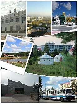
Pictures
- Dayan Town
 Places in Dayan Town
 No.1 Colliery of Dayan in 1990s
 Winter of Dayan Town
- The other Administrative Divisions in Evenk Banner
 Ewenki Museum in the town of Bayan Toi
.jpg) Honghuaerji National Forest Park
Honghuaerji National Forest Park Simplified Chinese: 巴音塔拉达斡尔民族乡
References
- ↑ "鄂温克族自治旗2013年国民经济和社会发展统计公报". People’s Government of Ewenki Autonomous Banner. Retrieved 2016-10-06.
External links
| Wikimedia Commons has media related to Ewenki Autonomous Banner. |