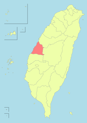
Changhua
| Changhua 彰化市 | |
|---|---|
| County-administered city | |
 | |
| Nickname(s): Bamboo Town (Chinese: 半線城) | |
 | |
| Coordinates: 24°04′N 120°32′E / 24.067°N 120.533°ECoordinates: 24°04′N 120°32′E / 24.067°N 120.533°E | |
| Country | Republic of China (Taiwan) |
| County | Changhua County |
| Government | |
| • Type | County-controlled city |
| • Mayor | Chiu Chien-fu (DPP)[1] |
| Area | |
| • Total | 65.68 km2 (25.36 sq mi) |
| Population (December 2014) | |
| • Total | 235,022 |
| • Density | 3,600/km2 (9,300/sq mi) |
| Website |
www |
| Changhua | |||||||||||||
| Chinese | 彰化市 | ||||||||||||
|---|---|---|---|---|---|---|---|---|---|---|---|---|---|
| |||||||||||||

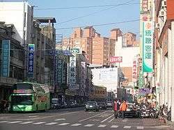
Changhua, officially known as Changhua City (Chinese: 彰化市; Pe̍h-ōe-jī: Chiang-hoà-chhī), is a county-administered city and the county seat of Changhua County in Taiwan. For many centuries the site was home to a settlement of Babuza people, a coastal tribe of Taiwanese aborigines. Changhua city is ranked first by population among county-administered cities. Historically, Changhua city was a base for the Hans when they invaded Taiwan and to defend from the Taiwanese aborigines, a fortress built out of bamboo was made. Thus Changhua has earned its name as "Bamboo Town".
Changhua is best known for its landmark statue of the Buddha. At 26 metres tall, the statue sits atop Bagua Mountain overlooking the city. The main walkway up to the giant is lined with statues of figures from Buddhist lore. Another site of interest is Taiwan's oldest temple honoring Confucius.
History
Poasoa (transliterated into Chinese: 半線; Pe̍h-ōe-jī: Pòaⁿ-sòaⁿ) was once a center of settlement for the Babuza people (a plains aboriginal tribe). During the Dutch period, the area was under the administration of Favorlang (modern-day Huwei, Yunlin) and was controlled by the Dutch East India Company. During the Siege of Fort Zeelandia, the area was also one of Koxinga's central defense and attack bases. During the Chinese immigration of the 17th century, Changhua city was one of the four cities that had major immigration; it was one of the oldest Han Chinese settlements.
By 1694, Poasoa Village (半線庄) had been established. During the late 17th to late 19th century the area continued to be one of the major urban settlements in central Taiwan. In 1723, Changhua County was established, following the Zhu Yigui rebellion. Despite that, rebellions and civil wars continued.
Empire of Japan
The origin of today's Changhua City is attributed to the Japanese administration, as they made the city into the official county seat in 1897 under Taichū Ken (Japanese: 臺中縣). During this era, the Japanese pronunciation Shōka came into use, alongside the "Chinese spellings" of "Changwha, Changhwa, Changhoa, Chanhue, Chan-hua, Tchanghoua".[2]
In 1901, the local administrative unit Shōka Chō (彰化廳) was established,[3] but this merged with Taichū Chō (臺中廳) in 1909. In 1920, Shoka was governed under the new Taichū Prefecture. In 1933, Ōtake Village (大竹庄) and Nankaku Village (南郭庄) were merged with Shōka Town and upgraded to Shōka City.
Republic of China
After the handover of Taiwan from Japan to the Republic of China on 25 October 1945, Changhua City was established as provincial city of Taiwan Province on 25 December the same year. On 30 November 1951, the Changhua City Office was established and subsequently on 1 December 1951, it was downgraded to county-administered city and became the county seat of Changhua County until today.[4]
Geography
Changhua city has plenty of flat lands, however, the flat lands are divided in two portions by the Central Mountain Range of Taiwan. One on the South Eastern area and the other on the North Western area. The North Eastern area, although being flat, is often affected by soil erosion caused by typhoons during the summer, thus is not suitable for living.
The temperature of Changhua city on average is 22.4°C, annually, with July being the hottest and January being the coolest. Annual rainfall is 1723.4 mm, June being the wettest and November being the driest. Rainfall decreases westward closer to the coastline.
Administrative divisions
Changhua City is divided into the following villages (in romanized alphabetical order):
Anxi, Ayi, Baobu, Chenggong, Citong, Datong, Dazhu, Fuan, Fugui, Fushan, Futian, Fuxing, Guangfu, Guanghua, Guangnan, Guashan, Guosheng, Guyi, Hediao, Huabei, Huayang, Jiadong, Jianan, Jianbao, Jieshou, Kuaiguan, Longshan, Lunping, Minquan, Minsheng, Nanan, Nanmei, Nanxing, Nanyao, Niupu, Pinghe, Sancun, Shipai, Taifeng, Taoyuan, Tianzhong, Tungfang, Tungxing, Wanan, Wanshou, Wenhua, Wuquan, Xiabu, Xian Xiangshan, Xiangyang, Xingbei, Xinhua, Xinxing, Xinyi, Xishi, Xixing, Yangming, Yanhe, Yanping, Yongfu, Yongsheng, Zhangan, Zhangle, Zhongquan, Zhongshan, Zhongxiao, Zhongyang, Zhongzheng, Zhongzhuang, Zhuanyao, Zhuxiang and Zhuzhong.
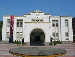
Government institutions
Economy
Changhua city is one of the more developed areas of Changhua county, from 1970 a trend of industrialization has been ongoing. This is reflected by an increase of factories in Changhua and decreasing amount of agricultural fields. However, Changhua city has a considerable amount of pollution as a result of this industrialization. From a poll in 1992, 43.2% of respondents work in the servicing sector, 42.4% works in industrial sector and only 14.4% works either in agricultural or the fishing sector. The local Changhua city government has a plan to expand the city from the current 12.35 km2 to 22.61 km2 with the hope to boost the standard of living as well.
Education
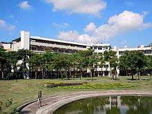
Due to Changhua city's urban nature it owns more educational resources allocated by the local government compared to neighboring townships or cities of Changhua county. The earliest school in Changhua dates back to 1726 during the Qing dynasty. In addition, the Japanese also improved the education system in Changhua city during World War II. As of the time this is written, Changhua city owns 15 elementary schools, 7 junior high schools, 7 senior high schools and 2 technical/universities.
Universities
High schools
Libraries
Tourist attractions
- 1895 Baguashan Anti-Japanese Martyrs' Museum[7]
- Anti-Japanese Martyrs' Monument Park
- Baguashan Great Buddha
- Changhua Arts Hall
- Changhua County Art Museum
- Changhua Nanyao Temple Cultural Hall
- Changhua Wude Hall
- Confucian Temple of Changhua
- Fan-shaped Roundhouse
- Gu-Yue Folk Museum
- Huayang Park
- Hsinding Old Street
- Kaihua Temple
- Lai Ho Memorial Hall
- Literature Walk
- Museum of Traditional Nan Bei Music and Theater
- Nanyao Temple
- National Changhua Living Art Center
- Natural Ecology Garden
- Red Hair Well
- Silver Bridge
- Spring of Youth
- Yuan Ching Kaun Tradition Art Museum
- Yuanching Temple
Transportation

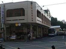
Changhua Station is currently the only Taiwan Railway Administration in Changhua city.
Freeway 1 connects Changhua city to Taichung city and this is one of the primary route for commuters between Changhua city and Taichung city as well.
Freeway 1 intersects with National Highway 3 at Changhua and connects to Provincial Highway 74.
Others
On 25 May 2002 China Airlines Flight 611 broke into pieces in mid-air. Parts of the plane landed in Changhua.[8][9]
References
- ↑ "Changhua City Office: About the Mayor". changhua.gov.tw.
- ↑ Davidson, James Wheeler (1903). The Island of Formosa, Past and Present : history, people, resources, and commercial prospects : tea, camphor, sugar, gold, coal, sulphur, economical plants, and other productions. London and New York: Macmillan. p. 261. OL 6931635M.
- ↑ Davidson (1903), p. 597.
- ↑ "Get to Know Changhua City". Changhua City Office. Retrieved 3 March 2017.
- ↑ "National Changhua University of Education - NCUE". educations.com.
- ↑ "Chienkuo Technology University, Changhua 建國科技大學". tealit.com.
- ↑ "1895 Baguashan Anti-Japanese Martyrs' Museum - - Attractions - Travel in Changhua County". chcg.gov.tw.
- ↑ "Changhua," BBC
- ↑ "225 die in China Airlines crash," The Independent
External links
| Wikimedia Commons has media related to Changhua City. |