Vintondale, Pennsylvania
| Vintondale, Pennsylvania | |
|---|---|
| Borough | |
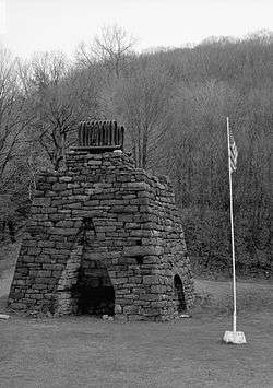 Eliza Furnace, a historic site in the borough | |
 Location of Vintondale in Cambria County, Pennsylvania. | |
 Vintondale Location of Vintondale in Cambria County, Pennsylvania. | |
| Coordinates: 40°28′42″N 78°54′51″W / 40.47833°N 78.91417°WCoordinates: 40°28′42″N 78°54′51″W / 40.47833°N 78.91417°W | |
| Country | United States |
| State | Pennsylvania |
| County | Cambria |
| Incorporated | 1907 |
| Government | |
| • Type | Borough council |
| Area[1] | |
| • Total | 0.49 sq mi (1.26 km2) |
| • Land | 0.47 sq mi (1.22 km2) |
| • Water | 0.02 sq mi (0.04 km2) |
| Elevation | 1,473 ft (449 m) |
| Population (2010) | |
| • Total | 414 |
| • Estimate (2016)[2] | 385 |
| • Density | 819.15/sq mi (316.40/km2) |
| Time zone | UTC-5 (Eastern (EST)) |
| • Summer (DST) | UTC-4 (EDT) |
| ZIP code | 15961 |
| Area code(s) | 814 |
| FIPS code | 42-80288 |
Vintondale is a borough in Cambria County, Pennsylvania, United States. It is part of the Johnstown, Pennsylvania Metropolitan Statistical Area. The population was 414 as of the 2010 census.[3]
History
Vintondale was founded by Warren Delano, maternal uncle of President Franklin Delano Roosevelt. He was a property owner and mayor of the town.
The Eliza Furnace was listed on the National Register of Historic Places in 1991.[4]
Geography
Vintondale is located on the western border of Cambria County at 40°28′42″N 78°54′51″W / 40.47833°N 78.91417°W (40.478370, -78.914097),[5] along the South Branch of Blacklick Creek. It is at the approximate midpoint of the Ghost Town Trail, a rail trail extending through Cambria and Indiana counties.
Vintondale is 13 miles (21 km) west of Ebensburg, the Cambria County seat, 14 miles (23 km) north of the city of Johnstown, and 21 miles (34 km) southeast of the borough of Indiana.
According to the United States Census Bureau, Vintondale has a total area of 0.49 square miles (1.26 km2), of which 0.47 square miles (1.22 km2) is land and 0.02 square miles (0.04 km2), or 3.49%, is water.[3]
Landscape art
Vintondale is the home of Litmus Gardens, an environmental art project.[6][7]
Demographics
| Historical population | |||
|---|---|---|---|
| Census | Pop. | %± | |
| 1910 | 1,410 | — | |
| 1920 | 2,053 | 45.6% | |
| 1930 | 1,658 | −19.2% | |
| 1940 | 1,516 | −8.6% | |
| 1950 | 1,185 | −21.8% | |
| 1960 | 938 | −20.8% | |
| 1970 | 812 | −13.4% | |
| 1980 | 697 | −14.2% | |
| 1990 | 582 | −16.5% | |
| 2000 | 528 | −9.3% | |
| 2010 | 414 | −21.6% | |
| Est. 2016 | 385 | [2] | −7.0% |
| Sources:[8][9][10] | |||
As of the census[9] of 2000, there were 528 people, 210 households, and 145 families residing in the borough. The population density was 1,143.7 people per square mile (443.2/km²). There were 231 housing units at an average density of 500.4 per square mile (193.9/km²). The racial makeup of the borough was 100.00% White. Hispanic or Latino of any race were 0.76% of the population.
There were 210 households, out of which 29.0% had children under the age of 18 living with them, 54.8% were married couples living together, 11.0% had a female householder with no husband present, and 30.5% were non-families. 26.7% of all households were made up of individuals, and 21.0% had someone living alone who was 65 years of age or older. The average household size was 2.51 and the average family size was 3.04.
In the borough the population was spread out, with 22.3% under the age of 18, 7.0% from 18 to 24, 24.8% from 25 to 44, 24.1% from 45 to 64, and 21.8% who were 65 years of age or older. The median age was 42 years. For every 100 females there were 102.3 males. For every 100 females age 18 and over, there were 96.2 males.
The median income for a household in the borough was $22,386, and the median income for a family was $34,688. Males had a median income of $25,000 versus $11,908 for females. The per capita income for the borough was $11,689. About 9.4% of families and 8.6% of the population were below the poverty line, including 2.8% of those under age 18 and 6.6% of those age 65 or over.
References
- ↑ "2016 U.S. Gazetteer Files". United States Census Bureau. Retrieved Aug 13, 2017.
- 1 2 "Population and Housing Unit Estimates". Retrieved June 9, 2017.
- 1 2 "Geographic Identifiers: 2010 Demographic Profile Data (G001): Vintondale borough, Pennsylvania". U.S. Census Bureau, American Factfinder. Retrieved March 19, 2015.
- ↑ National Park Service (2010-07-09). "National Register Information System". National Register of Historic Places. National Park Service.
- ↑ "US Gazetteer files: 2010, 2000, and 1990". United States Census Bureau. 2011-02-12. Retrieved 2011-04-23.
- ↑ "Litmus Gardens, Vintondale". Time. Archived from the original (photo gallery) on June 26, 2007. Retrieved 2008-11-10.
- ↑ "Ecological Restoration". Retrieved 2008-11-10.
- ↑ "Census of Population and Housing". U.S. Census Bureau. Retrieved 11 December 2013.
- 1 2 "American FactFinder". United States Census Bureau. Retrieved 2008-01-31.
- ↑ "Incorporated Places and Minor Civil Divisions Datasets: Subcounty Resident Population Estimates: April 1, 2010 to July 1, 2012". Population Estimates. U.S. Census Bureau. Archived from the original on 17 June 2013. Retrieved 11 December 2013.
Municipalities and communities of Cambria County, Pennsylvania, United States | ||
|---|---|---|
| City | 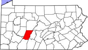 | |
| Boroughs |
| |
| Townships | ||
| CDPs | ||
| Unincorporated communities | ||
| Footnotes | ‡This populated place also has portions in an adjacent county or counties | |