Ortler Alps
| Ortler Alps | |
|---|---|
|
Italian: Gruppo dell'Ortles-Cevedale German: Ortler-Alpen | |
 Ortler Alps | |
| Highest point | |
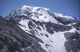
| Peak | Ortler |
| Elevation | 3,905 m (12,812 ft) |
| Coordinates | 46°30′32″N 10°32′42″E / 46.50889°N 10.54500°E |
| Geography | |
| Countries | Italy and Switzerland |
| Range coordinates | 46°27′N 10°37′E / 46.450°N 10.617°ECoordinates: 46°27′N 10°37′E / 46.450°N 10.617°E |
| Parent range | Southern Limestone Alps |
| Borders on | Livigno Range and Adamello-Presanella |
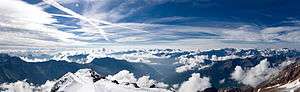
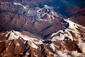
The Ortler Alps (Italian: Ortles-Cevedale [ˌɔrtlestʃeveˈdaːle]; German: Ortler-Alpen) are a mountain range of the Southern Limestone Alps mountain group in the Central Eastern Alps, in Italy and Switzerland.
Geography
The Ortler Alps are separated from:
- the Livigno Range in the north-west by the Stelvio Pass and the Adda River valley (Valtellina)
- the Adamello-Presanella range in the south by the Tonale Pass
- the Ötztal Alps in the north-east by the upper Adige valley (Vinschgau).
The part west of the Gavia Pass is also called Sobretta-Gavia Group.
The Ortler Alps are drained by the rivers Adda, Oglio, Adige and its tributary Noce.
Peaks
The main peaks of the Ortler Alps are:
| Peak (Italian) | (German) | metres | feet |
|---|---|---|---|
| Ortles | Ortler | 3,905 | 12,811 |
| Gran Zebrù | Königspitze | 3,857 | 12,655 |
| Monte Cevedale | Zufallspitze | 3,774 | 12,382 |
| Monte Zebrù | 3,735 | 12,254 | |
| Palón della Mare | 3,705 | 12,156 | |
| Punta San Matteo | 3,692 | 12,113 | |
| Monte Vioz | 3,645 | 11,959 | |
| Punta Thurwieser | Thurwieserspitze | 3,641 | 11,946 |
| Pizzo Tresero | 3,602 | 11,818 | |
| Cima Vertana | Vertainspitze | 3,541 | 11,618 |
| Punta delle Bàite | Tuckettspitze | 3,458 | 11,346 |
| Cima Sternai | Hintere Eggenspitze | 3,443 | 11,296 |
| Gioveretto | Zufrittspitze | 3,439 | 11,283 |
| Cima Venezia | Veneziaspitze | 3,384 | 11,103 |
| Croda di Cengles | Tschenglser Hochwand | 3,378 | 11,083 |
| Monte Confinale | 3,370 | 11,057 | |
| Corno dei Tre Signori | 3,360 | 11,024 | |
| Monte Sobretta | 3,296 | 10,814 | |
| Orecchia di Lepre | Hasenöhrl | 3,257 | 10,686 |
| Monte Gavia | 3,223 | 10,574 | |
| Piz Umbrail (Romansh) | 3,033 | 9,951 | |
| Piz Lad (Romansh) | 2,882 | 9,455 |
Mountain passes
The main mountain passes of the Ortler Alps are:
| Mountain pass | location | type | elevation | |
|---|---|---|---|---|
| m | ft | |||
| Hochjoch | Sulden to the Zebrù valley | snow | 3536 | 11,602 |
| Vioz Pass | Santa Caterina Valfurva to Peio | snow | 3337 | 10,949 |
| Königsjoch | Sulden to Santa Caterina | snow | 3295 | 10,811 |
| Cevedale Pass | Santa Caterina to Martell | snow | 3271 | 10,732 |
| Eissee Pass | Sulden to Martell | snow | 3133 | 10,279 |
| Passo del Zebru | Santa Caterina to the Zebrù valley | snow | 3025 | 9925 |
| Sallentjoch | Martell to Bagni di Rabbi | snow | 3021 | 9913 |
| Sforzellina Pass | Santa Caterina to Peio | snow | 3005 | 9859 |
| Tabarettascharte | Sulden to Trafoi | foot path | 2883 | 9459 |
| Stelvio Pass/Stilfserjoch | Trafoi to Bormio | road | 2760 | 9055 |
| Gavia Pass | Santa Caterina to Ponte di Legno | road | 2637 | 8651 |
History
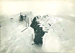
The Ortler Alps were part of the Italian front during World War I. In this area, the Austro-Hungarians and the Italians dug in during a trench war fought at altitudes above 3,000 m (10,000 ft) for most of the war. Some trenches are still visible today, and war relics continue to be found in the area.
External links

Mountain ranges of the Southern Limestone Alps according to the AVE | ||
|---|---|---|