Asinara National Park
| Parco Nazionale dell'Asinara | |
|---|---|
|
IUCN category II (national park) | |
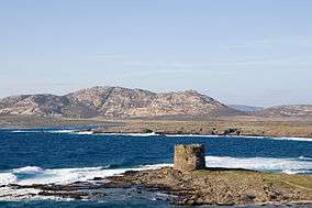 Asinara Island | |
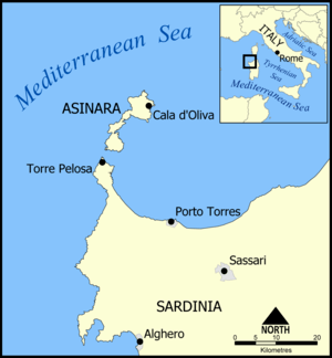 Map of Asinara Island | |
| Location | Sardinia |
| Nearest city | Porto Torres |
| Coordinates | 41°03′29″N 8°16′34″E / 41.058°N 8.276°ECoordinates: 41°03′29″N 8°16′34″E / 41.058°N 8.276°E |
| Area | 746.53 km2 (288.24 sq mi) |
| Governing body | Ministero dell'Ambiente |
|
www | |
Asinara is the third largest island of Sardinia after Sant'Antioco. It houses a great variety of habitats. The island has an extremely odd historical, environmental, and legal status. It is known as "Isola del Diavolo" ("Devil's Island"), since it was used as a quarantine location, as a prison camp during the First World War, and as one of the most important Italian high security prisons during the terrorist period of the 1970s and during the struggle against organized crime, until the establishment of a National Park in 1997.

The endemic local Albino Donkey
See also
References
- Yearbook of the Italian Parks 2005, edited by Comunicazione in association with Federparchi and the Italian State Tourism Board ISBN 88-7585-011-9
External links
| Authority control |
|---|
This article is issued from
Wikipedia.
The text is licensed under Creative Commons - Attribution - Sharealike.
Additional terms may apply for the media files.