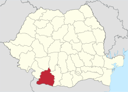
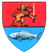
Dolj County
| Dolj County Județul Dolj | ||
|---|---|---|
| County | ||
| ||
 | ||
| Coordinates: 44°10′N 23°42′E / 44.17°N 23.7°ECoordinates: 44°10′N 23°42′E / 44.17°N 23.7°E | ||
| Country |
| |
| Development region1 | Sud-Vest | |
| Historic region | Oltenia | |
| Capital city | Craiova | |
| Government | ||
| • Type | County Board | |
| • President of the County Board | Ion Prioteasa | |
| • Prefect2 | Silviu Dumitru | |
| Area | ||
| • Total | 5,562 km2 (2,148 sq mi) | |
| Area rank | 7th in Romania | |
| Population (2011[1]) | ||
| • Total | 660,544 | |
| • Rank | 7th in Romania | |
| • Density | 89/km2 (230/sq mi) | |
| Time zone | UTC+2 (EET) | |
| • Summer (DST) | UTC+3 (EEST) | |
| Postal Code | 20wxyz3 | |
| Area code(s) | +40 x514 | |
| ISO 3166 code | RO-DJ | |
| Car Plates | DJ5 | |
| GDP | US$ 5.64 billion (2008) | |
| GDP/capita | US$ 7,673 (2008) | |
| Website |
County Board County Prefecture | |
|
1 The development regions of Romania have no administrative role and were formed in order to manage funds from the European Union 2 as of 2007, the Prefect is not a politician, but a public functionary. He (or she) is not allowed to be a member of a political party, and is banned from having any political activity in the first six months after his resignation (or exclusion) from the public functionaries' corps. 3w, x, y, and z are digits that indicate the city, the street, part of the street, or even the building of the address 4x is a digit indicating the operator: 2 for the former national operator, Romtelecom, and 3 for the other ground telephone networks 5used on both the plates of the vehicles that operate only in the county limits (like utility vehicles, ATVs, etc.), and the ones used outside the county | ||

Dolj County (Romanian pronunciation: [dolʒ] (![]()
Demographics
In 2011, it had a population of 660,544 and a population density of 89/km2 (230/sq mi).
| Year | County population[3] |
|---|---|
| 1948 | 615,301 |
| 1956 | |
| 1966 | |
| 1977 | |
| 1992 | |
| 2002 | |
| 2011 |
Geography
This county has a total area of 7,414 km2 (2,863 sq mi).
The entire area is a plain with the Danube on the south forming a wide valley crossed by the Jiu River in the middle. Other small rivers flow through the county, each one forming a small valley. There are some lakes across the county and many ponds and channels in the Danube valley. 6% of the county's area is a desert.[4]
Neighbours
- Olt County to the east.
- Mehedinți County to the west.
- Gorj County and Vâlcea County to the north.
- Bulgaria – Vidin Province to the southwest, Montana and Vratsa provinces to the south.
Economy
Agriculture is the county's main industry. The county has a land that is ideal for growing cereals, vegetables and wines. Other industries are mainly located in the city of Craiova, the largest city in southwestern Romania.
The county's main industries:
- Automotive industry – Ford has a factory.
- Heavy electrical and transport equipment – Electroputere Craiova is the largest factory plant in Romania.
- Aeronautics
- Chemicals processing
- Foods and beverages
- Textiles
- Mechanical parts and components
There are two small ports on the shore of the Danube river – Bechet and Calafat.
People
Tourism
Major tourist attractions:
Politics
The Dolj County Council, elected at the 2016 local government elections, is made up of 37 counselors, with the following party composition:[5]
| Party | Seats | Current County Council | |||||||||||||||||||||||||
|---|---|---|---|---|---|---|---|---|---|---|---|---|---|---|---|---|---|---|---|---|---|---|---|---|---|---|---|
| Social Democratic Party | 25 | ||||||||||||||||||||||||||
| National Liberal Party | 12 | ||||||||||||||||||||||||||
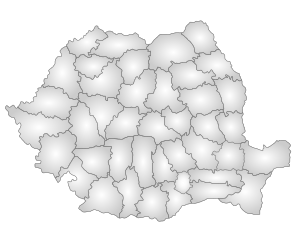
Administrative divisions
_vedere_central%C4%83.JPG)
Dolj County 3 municipalities, 4 towns and 104 communes
- Municipalities
- Towns
- Communes
- Afumați
- Almăj
- Amărăștii de Jos
- Amărăștii de Sus
- Apele Vii
- Argetoaia
- Bârca
- Bistreț
- Botoșești-Paia
- Brabova
- Brădești
- Braloștița
- Bratovoești
- Breasta
- Bucovăț
- Bulzești
- Călărași
- Calopăr
- Caraula
- Cârcea
- Cârna
- Carpen
- Castranova
- Catane
- Celaru
- Cerăt
- Cernătești
- Cetate
- Cioroiași
- Ciupercenii Noi
- Coșoveni
- Coțofenii din Dos
- Coțofenii din Față
- Daneți
- Desa
- Dioști
- Dobrești
- Dobrotești
- Drăgotești
- Drănic
- Fărcaș
- Galicea Mare
- Galiciuica
- Gângiova
- Ghercești
- Ghidici
- Ghindeni
- Gighera
- Giubega
- Giurgița
- Gogoșu
- Goicea
- Goiești
- Grecești
- Întorsura
- Ișalnița
- Izvoare
- Leu
- Lipovu
- Măceșu de Jos
- Măceșu de Sus
- Maglavit
- Malu Mare
- Mârșani
- Melinești
- Mischii
- Moțăței
- Murgași
- Negoi
- Orodel
- Ostroveni
- Perișor
- Pielești
- Piscu Vechi
- Plenița
- Pleșoi
- Podari
- Poiana Mare
- Predești
- Radovan
- Rast
- Robănești
- Rojiște
- Sadova
- Sălcuța
- Scăești
- Seaca de Câmp
- Seaca de Pădure
- Secu
- Siliștea Crucii
- Șimnicu de Sus
- Sopot
- Tălpaș
- Teasc
- Terpezița
- Teslui
- Țuglui
- Unirea
- Urzicuța
- Valea Stanciului
- Vârtop
- Vârvoru de Jos
- Vela
- Verbița
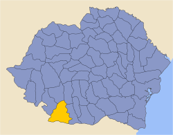
Historical county
| Județul Dolj | ||
|---|---|---|
| County (Județ) | ||
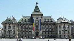 The building of the Dolj County prefecture from the interwar period. | ||
| ||
 | ||
| Country |
| |
| Historic region | Oltenia | |
| Capital city (Reședință de județ) | Craiova | |
| Area | ||
| • Total | 6,538 km2 (2,524 sq mi) | |
| Population (1930) | ||
| • Total | 485,149 | |
| • Density | 74/km2 (190/sq mi) | |
| Time zone | UTC+2 (EET) | |
| • Summer (DST) | UTC+3 (EEST) | |
Historically, the county was located in the southwestern part of Greater Romania, in the southwest part of the historical region of Oltenia. Its capital was Craiova. The interwar county territory comprised the central and southwestern part of the current Dolj county. It was bordered to the north with by the counties of Gorj and Valcea, to the west by Mehedinți County, to the east by Romanați County, and to the south by the Kingdom of Bulgaria.
Administration
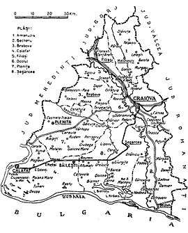
The county was originally divided into six administrative districts (plăṣi):[6]
- Plasa Amaradia, headquartered at Melinești
- Plasa Bârca, headquartered at Bârca
- Plasa Calafat, headquartered at Calafat
- Plasa Gângiova, headquartered at Gângiova
- Plasa Ocolul, headquartered at Ocolul
- Plasa Plenița, headquartered at Plenița
Subsequently, four districts were created in place of two of the prior districts (Plasa Bârca and Plasa Gângiova):
Population
According to the 1930 census data, the county population was 485,149 inhabitants, ethnically divided as follows: 96.7% Romanian, 0.5% Jews, 0.3% Germans, 0.3% Hungarians, as well as other minorities.[7] From the religious point of view, the population was 98.4% Eastern Orthodox, 0.7% Roman Catholic, 0.5% Jewish, as well as other minorities.
Urban population
In 1930, the county's urban population was 91,788 inhabitants, comprising 90.2% Romanians, 2.4% Jews, 2.2% Romanies, 1.7% Germans, 1.3% Hungarians, as well as other minorities.[7] From the religious point of view, the urban population was composed of 92.7% Eastern Orthodox, 3.1% Roman Catholic, 2.5% Jewish, 0.7% Lutheran, 0.3% Calvinist, 0.3% Greek Catholic, as well as other minorities.
References
| Wikimedia Commons has media related to Dolj County. |
- ↑ "Population at 20 October 2011" (in Romanian). INSSE. 5 July 2013. Retrieved 9 July 2013.
- ↑ "Populația după etnie" (PDF). National Institute of Statistics. Archived from the original (PDF) on 16 August 2009.
- ↑ National Institute of Statistics, "Populația la recensămintele din anii 1948, 1956, 1966, 1977, 1992 și 2002" Archived 22 September 2006 at the Wayback Machine.
- ↑ "Archived copy". Archived from the original on 26 June 2007. Retrieved 21 June 2007.
- ↑ "Mandate de CJ pe judete si competitori" (in Romanian). Biroul Electoral Central. 10 June 2016. Retrieved 16 June 2016.
- ↑ Portretul României Interbelice - Județul Dolj
- 1 2 Recensământul general al populației României din 29 decemvrie 1930, Vol. II, pag. 166