Harur
| Harur அரூர் | |
|---|---|
| city | |
 Harur Location in Tamil Nadu, India | |
| Coordinates: 12°03′07″N 78°29′08″E / 12.052°N 78.4855°ECoordinates: 12°03′07″N 78°29′08″E / 12.052°N 78.4855°E | |
| Country |
|
| State | Tamil Nadu |
| District | Dharmapuri |
| Government | |
| • Type | Assembly constituency |
| Area rank | city |
| Elevation | 350 m (1,150 ft) |
| Population (2011) | |
| • Total | 25,469 |
| Languages | |
| • Official | Tamil |
| Time zone | UTC+5:30 (IST) |
| PIN | 636903 |
| Telephone code | 04346 |
| Vehicle registration | TN 29 Z |
| Website | www.harur.com |
Harur is a main city in the Dharmapuri district of Tamil Nadu, India. It is one of two revenue blocks in the district.
Geography
The town is in northern Tamil Nadu, with an average elevation of 350 meters (1148 feet).
Demographics
According to the 2001 Indian census[1] Harur has a population of 20,346, 49.99 percent male and 50.01 percent female. Its literacy rate is 75.33 percent, higher than the national average of 59.5 percent. Male literacy is 82.34 percent and female literacy 68.32 percent. 11.72 percent of the population is under age six. Agriculture is the primary occupation.
Places of interest
- Theerthamalai – 14 km (8.7 mi) away
- Vallimadurai Dam – 7 km away
- Sitheri Hills – 26 km (16 mi) away
- Morappur Railway junction - 11 km away
- Muneeswaran temple - 14 km away
- Kammalampatty manavaalan temple - 5 km
- Hanumanthertham - 15 km - Hanuman Temple
- mallamapuram- 23 km -Ellammal temple.
- yercaud - 64.1 km away
- yelagiri hills - 47 km away
Dharmapuri District is the first district created in Tamil Nadu after Independence. 'Hogenakkal Falls or Hogenakal Falls', also referred as the "Niagara of India", is located in the Dharmapuri district. With its fame for medicinal baths and hide boat rides, it is a major tourist attraction. Another important tourist destination in the district is the hill-temple at Theerthamalai in Harur
Transportation
Road
Harur is connected by three state highways. There is bus service to Chennai, Salem, Coimbatore, Erode, Vellore, Tirupathi, Thiruvannamalai, Dharmapuri, Hosur, Bengaluru, Madurai. Harur has second Regional division office in Dharmapuri district.
Rail
The nearest railway station is at Morappur, 11 kilometres (6.8 mi) from Harur.
Places adjacent to Harur | ||||||||||
|---|---|---|---|---|---|---|---|---|---|---|
| ||||||||||
Mining
Granite
Harur is rich in high-quality gabbro, which is exported to Europe and North America.[2]
Molybdenum
Molybdenum was discovered near Harur by the Ministry of Mines in 2004. It is the only natural source of the metal in India. The ability of molybdenum to withstand extreme temperatures without significantly expanding or softening makes it useful in applications involving intense heat, including the manufacture of aircraft parts, electrical contacts, industrial motors and filaments.[3]
Education
Government College of Arts and Science Dharmapuri, Affiliated to Periyar University Established Year 1965. There are more than 30 Educational institutions in and around Harur and Government Engineering Collage near harur since 2015 . HARUR became 32nd educational district in Tamilnadu in 01.03.2018.
Government
Harur assembly constituency is part of the Dharmapuri Lok Sabha constituency.[4][5][6]
Gallery

 Vallimadurai Dam
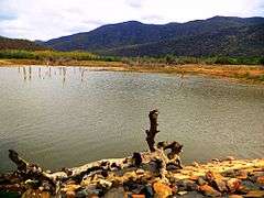 Vallimadurai Dam
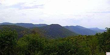 Sitheri Hills
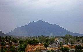 Theerthamalai
References
| Wikimedia Commons has media related to Harur. |
- ↑ "Census of India 2001: Data from the 2001 Census, including cities, villages and towns (Provisional)". Census Commission of India. Archived from the original on 2004-06-16. Retrieved 2008-11-01.
- ↑ http://www.citt.gc.ca/dumping/inquirie/findings/archive_nq93006_e.asp#I13%7Cname=Canadian International Trade Tribunal of Black Granite
- ↑ Emsley, John (2001). Nature's Building Blocks. Oxford: Oxford University Press. pp. 262–266. ISBN 0-19-850341-5.
- ↑ "List of Parliamentary and Assembly Constituencies" (PDF). Tamil Nadu. Election Commission of India. Archived from the original (PDF) on 2006-05-04. Retrieved 2008-10-09.
- ↑ http://www.drknmuthu.com
- ↑ http://www.periyaruniversity.ac.in