Crystal City station (Washington Metro)
Crystal City | ||||||||||||||||||||||||||||||||||||||||||||||||||
|---|---|---|---|---|---|---|---|---|---|---|---|---|---|---|---|---|---|---|---|---|---|---|---|---|---|---|---|---|---|---|---|---|---|---|---|---|---|---|---|---|---|---|---|---|---|---|---|---|---|---|
|
| ||||||||||||||||||||||||||||||||||||||||||||||||||
 | ||||||||||||||||||||||||||||||||||||||||||||||||||
| Location |
1750 South Clark Street Arlington, VA 22202 | |||||||||||||||||||||||||||||||||||||||||||||||||
| Coordinates | 38°51′28″N 77°03′03″W / 38.857856°N 77.050874°WCoordinates: 38°51′28″N 77°03′03″W / 38.857856°N 77.050874°W | |||||||||||||||||||||||||||||||||||||||||||||||||
| Owned by | WMATA | |||||||||||||||||||||||||||||||||||||||||||||||||
| Line(s) |
| |||||||||||||||||||||||||||||||||||||||||||||||||
| Platforms | 2 side platforms | |||||||||||||||||||||||||||||||||||||||||||||||||
| Tracks | 2 | |||||||||||||||||||||||||||||||||||||||||||||||||
| Connections |
| |||||||||||||||||||||||||||||||||||||||||||||||||
| Construction | ||||||||||||||||||||||||||||||||||||||||||||||||||
| Structure type | Underground | |||||||||||||||||||||||||||||||||||||||||||||||||
| Bicycle facilities | 10 racks | |||||||||||||||||||||||||||||||||||||||||||||||||
| Disabled access | Yes | |||||||||||||||||||||||||||||||||||||||||||||||||
| Other information | ||||||||||||||||||||||||||||||||||||||||||||||||||
| Station code | C09 | |||||||||||||||||||||||||||||||||||||||||||||||||
| History | ||||||||||||||||||||||||||||||||||||||||||||||||||
| Opened | July 1, 1977 | |||||||||||||||||||||||||||||||||||||||||||||||||
| Traffic | ||||||||||||||||||||||||||||||||||||||||||||||||||
| Passengers (2016) |
11,179 daily [1] | |||||||||||||||||||||||||||||||||||||||||||||||||
| Services | ||||||||||||||||||||||||||||||||||||||||||||||||||
| ||||||||||||||||||||||||||||||||||||||||||||||||||
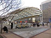
Crystal City is a side platformed Washington Metro station in the Crystal City neighborhood of Arlington, Virginia, United States. The station was opened on July 1, 1977, and is operated by the Washington Metropolitan Area Transit Authority (WMATA). Providing service for both the Blue and Yellow Lines, the station is located on 18th Street in between the Jefferson Davis Memorial Highway and South Bell Street. The station is also accessible from the underground network of shopping centers and restaurants extending beneath Crystal City.
This is the final indoor transfer point between the Blue and Yellow lines in the southbound direction. In inclement weather, commuters may prefer to transfer at Crystal City rather than at King Street–Old Town, which is outdoors.
The station is also served by the Metroway bus rapid transit line. Some Metroway buses terminate here rather than at Pentagon City station.
History
The station opened on July 1, 1977.[2] Its opening coincided with the completion of 11.8 miles (19.0 km)[3] of rail between National Airport and RFK Stadium and the opening of the Arlington Cemetery, Capitol South, Eastern Market, Farragut West, Federal Center SW, Federal Triangle, Foggy Bottom–GWU, L'Enfant Plaza, McPherson Square, National Airport, Pentagon, Pentagon City, Potomac Avenue, Rosslyn, Smithsonian and Stadium–Armory stations.[4]
Since summer 1992, Virginia Railway Express has a nearby station with the same name on Crystal Drive.[5]
On August 24, 2014, the Metroway Bus Rapid Transit system opened and started servicing Crystal City.[6]
Station layout
| G | Street Level | Exit/entrance, bus and Metroway connections |
| M | Mezzanine | One-way faregates, ticket machines, station agent |
| P Platform level |
Side platform, doors will open on the right | |
| Southbound | ← ← | |
| Northbound | → → | |
| Side platform, doors will open on the right | ||
References
- ↑ "Metrorail Average Weekday Passenger Boardings" (PDF). WMATA. Retrieved April 26, 2017.
- ↑ Feaver, Douglas B. (July 1, 1977). "Today, Metro could be U.S. model". The Washington Post. p. A1.
- ↑ "Sequence of Metrorail openings" (PDF). Washington Metropolitan Area Transit Authority. 2017. p. 3. Retrieved February 11, 2018.
- ↑ Staff Reporters (June 24, 1977). "Metro's newest stations: Where they are, what's nearby". The Washington Post.
- ↑ Fehr, Stephen C. (June 18, 1992). "Getting on track; Fairfax ready to roll with its 3 commuter stations". The Washington Post.
- ↑ "Metroway premium transit service starting this summer" (Press release). WMATA. July 1, 2014. Retrieved June 25, 2016. }
External links
![]()
- WMATA: Crystal City Station
- StationMasters Online: Crystal City Station
- 18th Street entrance from Google Maps Street View