Confins
| Confins | |||
|---|---|---|---|
| City | |||
| |||
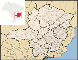 Location in Minas Gerais | |||
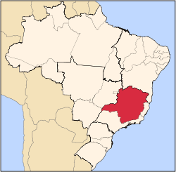
 Confins Location in Brazil | |||
| Coordinates: 19°37′45″S 43°59′30″W / 19.62917°S 43.99167°WCoordinates: 19°37′45″S 43°59′30″W / 19.62917°S 43.99167°W | |||
| Country |
| ||
| Region | Southeast | ||
| State | Minas Gerais | ||
| Mesoregion | Metropolitan of Belo Horizonte | ||
| Microregion | Belo Horizonte | ||
| Incorporated | December 21st, 1995 | ||
| Government | |||
| • Mayor | Geraldo Gonçalves dos Santos | ||
| Area[1] | |||
| • Total | 16,219 sq mi (42,008 km2) | ||
| Population (2013)[2] | |||
| • Total | 6,336 | ||
| Time zone | UTC-3 (BRT) | ||
| • Summer (DST) | UTC-2 (BRST) | ||
| Area code(s) | 31 | ||
| HDI (2010) [3] | 0.747 | ||
| Website | Official Website | ||


Confins is a Brazilian municipality located in the state of Minas Gerais. Its population as of 2006 is estimated to be 5,802 people. The area of the municipality is 42.008 km². The city belongs to the mesoregion Metropolitana de Belo Horizonte and to the microregion of Belo Horizonte. It is home of the international airport of Belo Horizonte, Tancredo Neves International Airport.
References
- ↑ "Área territorial oficial" [Official Territorial Area] (in Portuguese). Brazilian Institute of Geography and Statistics (IBGE). 2002-10-10. Retrieved 2010-12-05.
- ↑ "Estimativa População 2013" [Population estimation - 2013] (PDF) (in Portuguese). Brazilian Institute of Geography and Statistics (IBGE). 2013-08-29. Retrieved 2013-08-29.
- ↑ "Ranking decrescente do IDH-M dos municípios do Brasil" [Ranking of HDI-M of Brazilian Municipalities] (PDF) (in Portuguese). United Nations Development Programme (UNDP). 2010. Retrieved 2013-08-03.
External links
See also
Capital: Belo Horizonte | |||||||||||||||||||||||||
|  | ||||||||||||||||||||||||
|
| |||||||||||||||||||||||||
| |||||||||||||||||||||||||
| |||||||||||||||||||||||||
| |||||||||||||||||||||||||
| |||||||||||||||||||||||||
| |||||||||||||||||||||||||
| |||||||||||||||||||||||||
| |||||||||||||||||||||||||
| |||||||||||||||||||||||||
| |||||||||||||||||||||||||
This article is issued from
Wikipedia.
The text is licensed under Creative Commons - Attribution - Sharealike.
Additional terms may apply for the media files.