Maria da Fé
| Maria da Fé | ||
|---|---|---|
| Municipality | ||
 Maria da Fé sign | ||
| ||
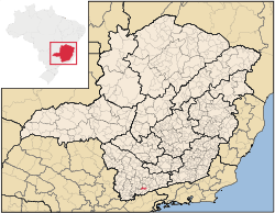 Location in the State of Minas Gerais | ||
| Coordinates: 22°18′28″S 45°22′30″W / 22.30778°S 45.37500°WCoordinates: 22°18′28″S 45°22′30″W / 22.30778°S 45.37500°W | ||
| Country |
| |
| Region | Southeast | |
| State |
| |
| Founded | June 1, 1912 | |
| Government | ||
| • Mayor | Adilson dos Santos | |
| Area | ||
| • Total | 203.774 km2 (78.678 sq mi) | |
| Elevation | 1,258 m (4,127 ft) | |
| Population (2008) | ||
| • Total | 14,646 | |
| • Density | 75.2/km2 (195/sq mi) | |
| Time zone | UTC-3 (BST) | |
| • Summer (DST) | UTC-2 (BDT) | |
| Postal Code | 37517-000 | |
| Website | Maria da Fé, Minas Gerais | |

Maria da Fé is a Brazilian municipality located in the state of Minas Gerais. Its population as of 2008 is estimated to be 14,646 people. The area of the municipality is 203.774 km². The city belongs to the mesoregion South/South-West of Minas Gerais and to the microregion of Itajubá.
See also
Gallery
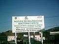 Maria da Fé olive oil project
This article is issued from
Wikipedia.
The text is licensed under Creative Commons - Attribution - Sharealike.
Additional terms may apply for the media files.