Ipanema Park

Our Lady of Hope Church of the Horto neighborhood
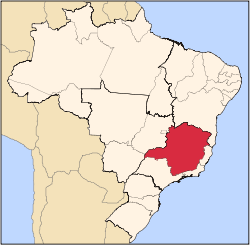
Ipatinga (postal code 35160-000) is a municipality located in eastern Minas Gerais state, Brazil. The city was founded in April 29, 1964 and covers a total area of 166.5 km². Its population is 240,338 (IBGE 2001). It is part of the Vale do Aço Metropolitan Area (population 430,700).
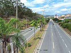
Ipatinga is located at the site where the Piracicaba River flows into the Doce River, 217 km. from the state capital of Belo Horizonte. It is served by highway and railroad connections (Minas-Vitória). There is also a medium-sized airport, Usiminas Airport [1] in the area of the neighbor city Santana do Paraíso, that serves the Steel Valley and can receive small and medium-sized planes, including jets like the Boeing 737 and the Fokker 100.
Industry
It is the most important city of the Vale do Aço (Steel Valley) metropolitan area and it is the headquarters for one of the largest steel making complexes in Brazil, Usina Siderúrgica de Minas Gerais – Usiminas.[2]
Environment
Despite the steel complex's presence, Ipatinga has 127 m2 of green area per inhabitant, one of the highest averages in the country. Parque Ipanema, Ipatinga's main park, has about one million square meters of green space with 12 thousand trees planted, one of the largest in the country.[3]
Sport
Ipatinga Futebol Clube, the city's principal football club won the state championship in 2005 and reached the Copa do Brasil semi-finals in 2006. In 2007, it placed 2nd on the National Championship's Serie B, climbing to the first division. Ipatinga Futebol Clube holds its home at Estádio Municipal Epaminondas Mendes Brito popularly known as Ipatingão. The stadium was founded in November 23, 1981, and it is considered the fourth biggest soccer stadium of the state of Minas Gerais.[4] In 2013 this team changed Ipatinga to Betim.
Statistics
- Elevation: 220 m
- Climate: Tropical sub-hot and sub-dry
- Average annual temperature: 23 °C
- Latitude South 19°28'46"
- Longitude West: 42°31'18"
- Distances from major cities:
- Belo Horizonte: 217 km
- Rio de Janeiro: 661 km
- São Paulo: 808 km
- Campinas: 830 km
- Vitória: 401 km
- Brasília: 935 km
- Salvador: 1140 km
External links
Coordinates: 19°30′S 42°32′W / 19.500°S 42.533°W / -19.500; -42.533
|
|---|
|
Mesoregion Campo das Vertentes |
|---|
| Barbacena | |
|---|
| Lavras | |
|---|
| São João del Rei | |
|---|
|
| |
Mesoregion Central Mineira |
|---|
| Bom Despacho | |
|---|
| Curvelo | |
|---|
| Três Marias | |
|---|
|
|
Mesoregion Jequitinhonha |
|---|
| Almenara | |
|---|
| Araçuaí | |
|---|
| Capelinha | |
|---|
| Diamantina | |
|---|
| Pedra Azul | |
|---|
|
|
Mesoregion Metropolitana de Belo Horizonte |
|---|
| Belo Horizonte | |
|---|
| Conceição do Mato Dentro | |
|---|
| Conselheiro Lafaiete | |
|---|
| Itabira | |
|---|
| Itaguara | |
|---|
| Ouro Preto | |
|---|
| Pará de Minas | |
|---|
| Sete Lagoas | |
|---|
|
|
Mesoregion Noroeste de Minas |
|---|
|
|
Mesoregion Norte de Minas |
|---|
| Bocaiúva | |
|---|
| Grão Mogol | |
|---|
| Janaúba | |
|---|
| Januária | |
|---|
| Montes Claros | |
|---|
| Pirapora | |
|---|
| Salinas | |
|---|
|
|
Mesoregion Oeste de Minas |
|---|
| Campo Belo | |
|---|
| Divinópolis | |
|---|
| Formiga | |
|---|
| Oliveira | |
|---|
| Piui | |
|---|
|
|
Mesoregion Sudoeste de Minas |
|---|
| Alfenas | |
|---|
| Andrelândia | |
|---|
| Itajubá | |
|---|
| Passos | |
|---|
| Poços de Caldas | |
|---|
| Pouso Alegre | |
|---|
| Santa Rita do Sapucaí | |
|---|
| São Lourenco | |
|---|
| São Sebastiao do Paraíso | |
|---|
| Varginha | |
|---|
|
|
Mesoregion Triângulo Mineiro/Alto Paranaiba |
|---|
| Araxá | |
|---|
| Frutal | |
|---|
| Ituiutaba | |
|---|
| Patos de Minas | |
|---|
| Patrocínio | |
|---|
| Uberaba | |
|---|
| Uberlândia | |
|---|
|
|
Mesoregion Vale do Mucuri |
|---|
|
|
Mesoregion Zona da Mata |
|---|
| Cataguases | |
|---|
| Juiz de Fora | |
|---|
| Manhuaçu | |
|---|
| Muriaé | |
|---|
| Ponte Nova | |
|---|
| Ubá | |
|---|
| Viçosa | |
|---|
|
|
Mesoregion Vale do Rio Doce |
|---|
| Aimorés | |
|---|
| Caratinga | |
|---|
| Governador Valadares | |
|---|
| Guanhães | |
|---|
| Ipatinga | |
|---|
| Mantena | |
|---|
| Peçanha | |
|---|
|
|