Lajinha
| Lajinha | ||
|---|---|---|
| Municipality | ||
| ||
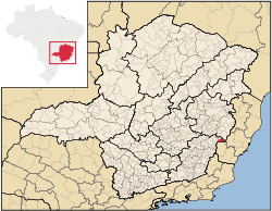
 Location in Minas Gerais state | ||
 Lajinha Location in Brazil | ||
| Coordinates: 20°9′3″S 41°37′22″W / 20.15083°S 41.62278°WCoordinates: 20°9′3″S 41°37′22″W / 20.15083°S 41.62278°W | ||
| Country |
| |
| Region | Southeast Region | |
| State | Minas Gerais | |
| Mesoregion | Zona da Mata | |
| Microregion | Manhuaçu | |
| Area | ||
| • Total | 431.92 km2 (166.77 sq mi) | |
| Population (2015) | ||
| • Total | 20,262 | |
| • Density | 47/km2 (120/sq mi) | |
| Time zone | BRT/BRST (UTC-3/-2) | |
Lajinha is a municipality in the northeastern part of the state of Minas Gerais, Brazil. The population is 20,262 (2015 est.) in an area of 431.92 km².[1] The town borders the state Espirito Santo to the east.
Neighboring municipalities
Population history
| Year | Population |
|---|---|
| 2004 | 20,706 |
| 2015 | 20,262 |
References
External links
- (in Portuguese) http://www.citybrazil.com.br/mg/lajinha/
This article is issued from
Wikipedia.
The text is licensed under Creative Commons - Attribution - Sharealike.
Additional terms may apply for the media files.
