County Meath
| County Meath Contae na Mí | ||
|---|---|---|
| ||
| Nickname(s): The Royal County | ||
|
Motto(s): Tré Neart le Chéile (Irish) "Stronger Together" | ||
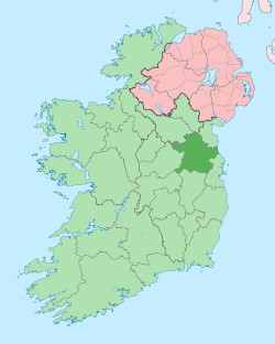 | ||
| Country | Ireland | |
| Province | Leinster | |
| Dáil Éireann |
Meath East Meath West Louth | |
| EU Parliament | Midlands–North-West | |
| County town | Navan | |
| Government | ||
| • Type | County Council | |
| Area | ||
| • Total | 2,342 km2 (904 sq mi) | |
| Area rank | 14th | |
| Population (2016) | 194,942 | |
| • Rank | 9th | |
| Vehicle index mark code | MH | |
| Website |
www | |
County Meath (/miːð/; Irish: Contae na Mí or simply an Mhí) is a county in Ireland. It is in the province of Leinster and is part of the Mid-East Region. It is named after the historic Kingdom of Meath (from Midhe meaning "middle" or "centre").[1] Meath County Council is the local authority for the county. According to the 2016 census, the population of the county is 195,044.[2] The county town of Meath is Navan. Other towns in the county include Trim, Kells, Laytown, Ashbourne, Dunboyne, and Slane.
It is only one of two counties to have an official Gaeltacht outside of the West of Ireland, the other being An Rinn in County Waterford, and the only county in Leinster to have an official Gaeltacht.
Geography and political subdivisions
The county is drained by the River Boyne.
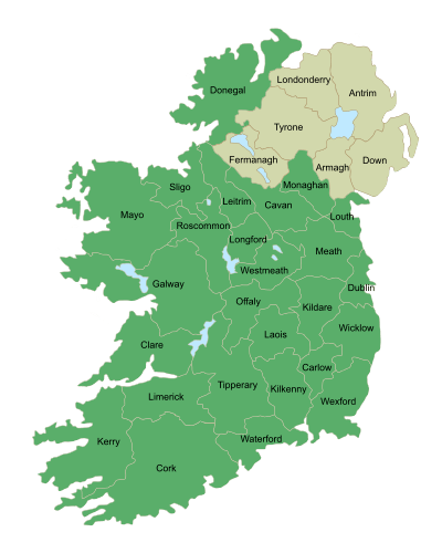
Meath is the 14th-largest of Ireland’s 32 counties in area, and the ninth-largest in terms of population.[3] It is the second-largest of Leinster’s 12 counties in size, and the third-largest in terms of population. The county town is Navan, where the county hall and government are located, although Trim, the former county town, has historical significance and remains a sitting place of the circuit court. County Meath also has the only two Gaeltacht areas in the province of Leinster, at Ráth Chairn and Baile Ghib. Meath has seven land borders and also a small stretch of coastline stretching from Mornington to Gormanston beach. The counties that Meath border are; Dublin, Westmeath, Louth, Offaly, Kildare, Cavan, and Monaghan.
Baronies
There are eighteen historic baronies in the county.[4] They include the baronies of Morgallion and Ratoath. While baronies continue to be officially defined units, they are no longer used for many administrative purposes. Their official status is illustrated by Placenames Orders made since 2003, where official Irish names of baronies are listed under "Administrative units".
Local government and politics
There are 40 elected members of Meath County Council. Fine Gael holds 13 seats, Fianna Fáil holds 10, Sinn Féin holds 8, and there are 9 independents. There are two Dáil constituencies, Meath West and Meath East, which together return 6 deputies to Dáil Éireann. Fianna Fáil currently holds 1 seat in each constituency, Fine Gael holds 2 in Meath East and 1 in Meath West, and Sinn Féin holds 1 in Meath West. Previously there was only one Meath constituency. Fianna Fáil held three seats out of five in the Meath constituency between 1987 and its abolition in 2007; Fine Gael won the other two seats in four of the five general elections in that period, with the exception of 1992, when it lost a seat to the Labour Party (which was regained in 1997). Meath East lies entirely within the borders of the county; Meath West includes part of the neighbouring county of Westmeath. Part of the county along the Irish Sea coast, known as East Meath, which includes Julianstown and Laytown-Bettystown-Mornington, is included in the Louth constituency.
History
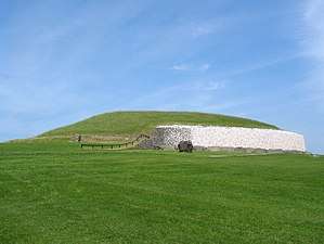
The county is colloquially known by the nickname "The Royal County", owing to its history as the seat of the High King of Ireland.[5][6][7] It formed from the eastern part of the former Kingdom of Mide (see Kings of Mide) but now forms part of the province of Leinster. Historically, the kingdom and its successor territory the Lordship of Meath, included all of counties Meath, Fingal and Westmeath as well as parts of counties Cavan, Longford, Louth, Offaly and Kildare. The seat of the High King of Ireland was at Tara. The archaeological complex of Brú na Bóinne is 5,000 years old, and includes the burial sites of Newgrange, Knowth and Dowth,[8] in the north-east of the county. It is a UNESCO-designated World Heritage Site.[9]
Places of interest
- The Hill of Tara, an ancient historical site - Ard Rí or high king of Ireland.
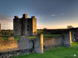
- Castles at Trim, Slane (private), Dunsany (limited opening) and Killeen (now a hotel).
- Religious ruins at Trim (two), Bective, Slane (two), Dunsany, Skryne (Skreen).
- 2500-year-old mound structures of disputed origin at Teltown. Teltown is home to Ireland's pre-Olympic Games The Tailteann Games , which some records date back to 1869 BCE.
- Brú na Bóinne Unesco World Heritage Site includes Newgrange
- Loughcrew, an ancient historical site.
- Dangan Castle (Summerhill), the family home of Field Marshal Arthur Wellesley, 1st Duke of Wellington, KG, GCB, GCH, PC, FRS.
- Tayto Park, Ireland's only theme park, is located close to Ashbourne.
- Trim Castle is Ireland's largest Norman castle and was the setting for many Norman-Irish parliaments.
- Meath is also home to Kells, with its round tower and monastic past, and Ireland's only inland lighthouse, the 18th century Spire of Lloyd.
- The Battle of the Boyne took place in Meath in 1690, close to the modern-day village of Donore
- During World War One a British army unit ran a detention camp for prisoners of war outside the town of Oldcastle.
Contemporary references
In Margaret Mitchell's novel Gone With The Wind, it is mentioned that Gerald O'Hara, Scarlett O'Hara's father, was born in County Meath. Tara is the name of the Georgia plantation on which the O'Hara family resided.
Famous Anglo-Irish MP Charles Stewart Parnell was elected member of parliament for Meath in Westminster in 1875 until 1880. Today he is locally commemorated by a small garden and courtyard in Kells town centre.
Demographics
.PNG)
The population in Co. Meath has been characterised since 1861 as being in a period of significant decline. Between 1861 and 1901 the population almost halved (110,373 to 67,497); the population stabilised from 1901 to 1971 (67,497 to 71,729) and there was a substantial increase between 1971 and 1981 to 95,419. This increase was mainly due to a baby boom locally. The population continued to increase at a constant rate, before increasing at an explosive rate between 1996 and 2002, from 109,732 to 134,005. This is due primarily to economic factors, with the return of residents to live in the county, and also an echo effect of the 1970s baby boom. The census of 2011 gives a statistic of 184,135 to include a dramatic increase in inward migration in the county, much of it from neighbouring Dublin and Drogheda.
This population growth has seen divergent trends emerge in recent years, with mild depopulation in the north and west of the county being more than offset by large increases in the population of the eastern and south-eastern parts of the county, principally owing to inward migration to districts that have good proximity via road to the business parks on the western outskirts of Dublin. The accession of Poland and Lithuania to the European Union in 2004 resulted in a significant influx of workers from these countries to work in low-wage sectors, including agriculture, quarrying, construction and catering.
| Main immigrant groups, 2016[10] | |
| Nationality | Population |
|---|---|
| 9,699 | |
| 4,229 | |
| 3,131 | |
| 1,402 | |
| 1,092 | |
| 945 | |
| 930 | |
| 465 | |
| 456 | |
| 442 | |
Urban areas and populations
| Town | Population 2016 |
|---|---|
| Navan | 30,173 |
| Ashbourne | 12,679 |
| Laytown-Bettystown-Mornington | 11,872 |
| Ratoath | 9,533 |
| Trim | 9,194 |
| Dunboyne | 7,272 |
| Kells | 6,135 |
| Southern environs of Drogheda | 5,000[11][12] |
| Duleek | 4,219 |
| Dunshaughlin | 4,035 |
| Stamullen | 3,360 |
| Enfield | 3,239 |
| Athboy | 2,445 |
| Oldcastle | 1,383 |
| Slane | 1,369 |
| Ballivor | 1,809 |
| Longwood | 1,581 |
| Kentstown | 1,179 |
Irish language
There are 2,533 Irish language speakers, or Gaeilgeoirí, in County Meath[13], with 1,299 native speakers in the Meath Gaeltacht. The Gaeltacht is split into an area northwest of Navan and east of Kells known as Baile Ghib and Domhnach Phádraig, and an area close to the town of Athboy and Trim, known as Rath Cháirn[14]. In addition there are 1,304 pupils attending the seven Gaelscoileanna outside the Gaeltacht area.[15] The Greater Dublin area has the highest number of Irish-medium schools in Ireland.
Economy
In farming, cattle, dairying, potatoes and grain are historically common in Meath. Recently production volumes have decreased due to competition for labour from other sectors of the economy. Migrant labour from Eastern Europe has helped however. Meath is Ireland's leading county producer of potatoes, and a significant producer of beef, barley, milk, wheat, and root vegetables.
Europe's largest underground lead-zinc mine, Tara Mines, has operated in the area since 1977, at a location to the west of Navan. Current ore production from the mine is 2,600,000 tonnes of ore per year, containing over 200,000 tonnes of zinc metal[16]. Glacial deposits of gravel exist in a band stretching from the Offaly border at Edenderry, to the sea at Laytown. This is the basis of a long quarrying tradition. A large cement plant near Duleek is situated in this territory.
An increasing proportion of Meath residents commute into Dublin, with a resulting shift to a services based economy in the developing dormitory towns.
Meat processing occurs in Clonee, and Navan. The latter, Navan, was historically a manufacturing town and involved in the household goods sector. Navan was a centre of the Irish furniture industry, though this declined as a source of employment. Navan was also a centre in the Irish Carpet making industry, before this was lost to overseas competition[17].
Horse breeding and training is also undertaken in the county, and there is localised tourism in Trim, Kells, Tara and the Boyne Valley.
Transport
Road
Rail
- Hansfield, Dunboyne and M3 Parkway have a frequent service to Dublin City Centre.
- Laytown has a frequent commuter service. The station is located on Dublin's 'Northern Commuter Line'
- There is a commuter train service (Western Commuter Line) from Enfield. Although the service is very infrequent (only 8 trains a day to Dublin with no direct trains 4 pm - 9 pm), not many villages like Enfield have a commuter service at all.
- Navan is currently served by a freight only spur railway line from Drogheda the on the Dublin-Belfast main line, for freight traffic (zinc and lead concentrates from Tara Mines in Navan to Dublin Port) connecting at Drogheda. The direct rail line remains abandoned, though its path is reasonably intact, and plans are drawn up to reopen it in line with current government transport policy. However, this plan has now been put on hold due to the economic downturn.
See also
References
- ↑ Everett-Heath, John (2010). The Concise Dictionary of World Place-Names. Oxford: Oxford University Press. ISBN 9780199580897. Archived from the original on 29 November 2016.
A county with a name meaning ‘The Middle (Kingdom)’, a reference to its east-central location in the island. It was one of the five ancient kingdoms of Ireland at which time it included the modern county of Westmeath.
- ↑ Census 2016 - County Meath Overview Archived 20 October 2017 at the Wayback Machine.
- ↑ Corry, Eoghan (2005). The GAA Book of Lists. Hodder Headline Ireland. pp. 186–191. ISBN 0-340-89695-7.
- ↑ Placenames Database of Ireland - Baronies.
- ↑ Meath County Council. "Meath - a rich and royal land". Archived from the original on 10 June 2010. Retrieved 21 May 2010.
- ↑ countymeath.com. "County Meath - Newgrange, Slane Castle and the Book of Kells". Archived from the original on 9 March 2010. Retrieved 21 May 2010.
- ↑ Rowan Kelleher, Suzanne (2004). Frommer's Ireland from $80 a Day (20th ed.). Hoboken, New Jersey, USA: Wiley Publishing, Inc. p. 204. ISBN 0-7645-4217-6.
- ↑ "Brú na Bóinne | World Heritage | World Heritage Ireland". www.worldheritageireland.ie. Archived from the original on 30 August 2017. Retrieved 5 September 2017.
- ↑ Centre, UNESCO World Heritage. "Brú na Bóinne - Archaeological Ensemble of the Bend of the Boyne". whc.unesco.org. Archived from the original on 4 October 2017. Retrieved 5 September 2017.
- ↑ "Population Usually Resident and Present in the State 2011 to 2016 by Sex, Aggregate Town or Rural Area, Birthplace, County of Usual Residence and CensusYear - StatBank - data and statistics". www.cso.ie. Archived from the original on 10 March 2018. Retrieved 2 May 2018.
- ↑ http://www.meath.ie/CountyCouncil/Publications/PlanningPublications/Laytown-BettystownPlanningPublications/Laytown-BettystownLocalAreaPlans2009-2015/File,36330,en.pdf Archived 25 July 2014 at the Wayback Machine.
- ↑ http://www.meath.ie/CountyCouncil/Publications/PlanningandDevelopmentPublications/CountyMeathDevelopmentPlan2007-2013-Adopted/File,6769,en.jpg Archived 19 January 2013 at the Wayback Machine.
- ↑ "ArcGIS Web Application". census.cso.ie. Archived from the original on 28 November 2017. Retrieved 2 May 2018.
- ↑ "An Mhí « Údarás na Gaeltachta". www.udaras.ie. Archived from the original on 18 December 2017. Retrieved 2 May 2018.
- ↑ "Oideachas Trí Mheán na Gaeilge in Éirinn sa Ghalltacht 2010-2011" (PDF) (in Irish). gaelscoileanna.ie. 2011. Archived (PDF) from the original on 19 April 2012. Retrieved 9 January 2012.
- ↑ https://vp217.alertir.com/afw/files/press/boliden/201703089998-1.pdf
- ↑ "Navan Historical Society - Navan Carpets". www.navanhistory.ie. Archived from the original on 19 November 2017. Retrieved 2 May 2018.
External links
| Wikimedia Commons has media related to County Meath. |
| Wikivoyage has a travel guide for County Meath. |
Places adjacent to County Meath | |
|---|---|