Mornington, County Meath
| Mornington Baile Uí Mhornáin | |
|---|---|
| Town | |
 Maiden Tower, Mornington, and Mouth of River Boyne | |
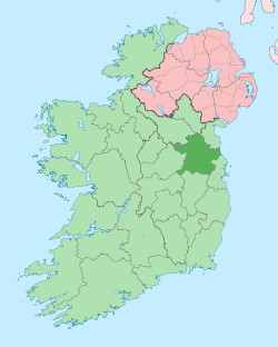
 Mornington Location in Ireland | |
| Coordinates: 53°43′17″N 6°17′2″W / 53.72139°N 6.28389°WCoordinates: 53°43′17″N 6°17′2″W / 53.72139°N 6.28389°W | |
| Country | Ireland |
| Province | Leinster |
| County | County Meath |
| Area | |
| • Total | 2.19 km2 (0.85 sq mi) |
| Elevation | 1 m (3 ft) |
| Time zone | UTC+0 (WET) |
| • Summer (DST) | UTC-1 (IST (WEST)) |
| Irish Grid Reference | O149759 |
Mornington (Irish: Baile Uí Mhornáin, meaning "Town of the Mariner") is a coastal village on the estuary of the River Boyne in County Meath, Ireland approximately 5 km downriver from the centre of Drogheda. Together with the neighbouring villages of Laytown and Bettystown it comprises the census town of Laytown-Bettystown-Mornington with a combined population of 10,889 at the 2011 Census, which is part of the wider area collectively known as East Meath.
The large townland of 1,223 acres (4.95 km2) is bound on the north by the River Boyne estuary and on the east by the Irish Sea. The townland extends along the seashore to Bettystown village and includes part of that village up to and including The Neptune Hotel.
Mornington can also refer to a larger area, a half-parish, within the Laytown-Mornington Roman Catholic Parish established in 1986, and formerly part of the Parish of St. Mary's in Drogheda. Mornington was also a former post office sub-district and used by a wider area for address purposes up to the 1980s.
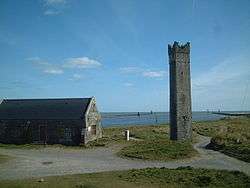
Maiden Tower and the Lady's Finger
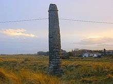
Mornington contains the Maiden Tower and the Lady's Finger, two structures most likely to have been navigational aids for ships entering the River Boyne prior to the 1765 walls being built. A ship approaching the river mouth would be lined up to safely enter the narrow channel when the view of the Lady's Finger was obscured behind the tower.
The Maiden Tower which stands 60 foot high was built during the reign of Queen Elizabeth I who came to the throne in 1558. It is suggested that it got its name from this association with the Virgin Queen and Sir William R. Wilde in his book "The Beauties of the Boyne ..." (1849) mentions this as a conjecture at that time. The tower was already in existence by 1582 when it was proposed to build at Ringsend a tower of such height and strength as shalbe of a perpetual continuance like the tower at Drogheda.[1][2][3] The original name of the Maiden Tower was Mayden Tower[4], the immediate area being known as Maydenhayes. Hayes is a common Old English derived place-name element, similar to the Norman-French haie, signifying a hedged-in enclosure. The name could therefore be older than the tower and the link with Elizabeth I something which accrued to the original name. The title Lord of Maydenhayes is currently in possession of Edmund J. McCormick, Jr, of Far Hills, New Jersey in the United States.
The tower was built as a warning beacon to sailors and marked the mouth of the river Boyne. At the topmost reaches of the tower one can command an extensive view over land and sea. Access to this parapet is by spiral steps tapering towards the top and through the barrel-vault at the top of the stairs. It is also believed to have acted as a look-out tower during the Elizabethan Wars with Spain (1585-1603) to give advance warning of approaching enemy ships.[5] The tower was vandalised in 2003.[6] Entry to the tower has been blocked by Meath County Council.
There are various folk stories about the tower and pillar. One were a faithful lady, awaiting the return of her husband, falls from the tower when an incorrect flag on his returning ship mistakenly signaled his death, echoes the fate of Aegeus father of Theseus. The lady's finger was then supposedly built by the returned husband in memory of his wife.
In 1819 a strange old woman, who had lived abroad for many years, took up residence at the top of the tower. She spent her time at her spinning wheel under a makeshift sail roof set up by local fishermen. She developed a reputation as a local hermit, donating her spinning work to the local church and refusing to tell her name became known simply as the 'lady of the tower'. In the severe winter of 1821 she had to abandon the tower and died soon after in a charitable institution in Drogheda.
Near to the tower and pillar is a listed building, an old Victorian boathouse, which originally served as a lifeboat station from 1872 to 1926. For many years it was a ruin but it was restored in 2007 as a residence. In 2018 it was for sale in conjunction with the surrounding 31 acres of dunes on which the Deepwater port had been proposed.
In 2015 Harvey Keitel filmed part of an insurance commercial at the tower.
Moran's Pub
Moran's Pub has been situated in the original centre of the village since the 1840s and remains the only pub between Bettystown and Drogheda. Run by Maggie Moran in the 1950s as a combined shop and bar and later by her children who remained unmarried, the last of the Morans; sisters Liz and Agnes and brothers Tommy, Frank and Johnnie Moran. The brothers also ran the farm as part of the family concern for many years. The traditional bar has been greatly expanded in recent years since being sold out of the family. However the original name, wood-panelling, counter and shop features have been retained and a new bar room put in which attempts to mirror the original look while providing the features of a modern pub. Rings is the traditional pub game played.
Fisheries and River Boyne
Mornington was traditionally a fishing village on the River Boyne based on salmon fishing and mussel dredging, however the nature of the area and of a fishing livelihood changed significantly at the time of "The Boom". By tradition St. Patrick blessed the fishermen at Inbhear Colpha, were the Colpe stream enters the Boyne in Mornington, as they gave him salmon when he asked for something to eat, in contrast to those on the Ainge, or Nanny Water whom he had cursed for being inhospitable. He said then the Mornington fishermen would always have fish.[7] The fishery was known as the lord's fishery by the early Stuart period and in 1603 King James granted Sir George Carew, vice-Chamberlain of the Queen "the tithes of the fish of Mornanston in the parish of Colpe".[8]
The fishing by draft nets was done from around 14[9] set stations and "Boyne salmon fishermen had a particular method of working which involved two men. One man stayed on shore holding a rope attached to the net, while the other rowed out into the river with the other end of the net. Once the whole net was spread out, the boatman rowed back to shore and the two men pulled the net to shore, trapping fish as it went".[10] Fishing took place from February to August. The salmon boats had a particular stern platform for holding the net. In 2006 amid concerns of dwindling spawning salmon numbers, the decision was taken to ban draft net fishing. Of the 50 fishermen then with licenses only 14 remained on and "they came to an agreement with the Inland Fisheries Ireland to take part in a scientific experiment that tags fish caught in the nets, under the eye of fishing inspectors. They are then released, allowing them to head back upstream".[11]
The tradition of mussel fishing, which existed for about 300 years[12], has also been suspended since 2006. A initial halt took place in 1998, as the river was being dredged, and while the beds were re-seeded the year afterward with the expectation of harvesting in 2003 re-establishment was poor. Then in 2006 the Drogheda Port Company undertook a second silt dredging this time from Tom Roe's Point deepwater berth to the viaduct at Drogheda. The fishing involved a particular currach-style boat or punt (also called a pram[13], or more commonly locally, a canoe) and a mussel rake with a twenty-foot pole, dredged by hand similar to that on the River Conwy in North Wales. These can be seen in these images of mussel dredging in the 1990s. Mussels were originally used as a food source in the Mornington-Baltray areas and only became a commercial fishery about 1902-1903[14]. The season ran over the winter from October to April and raking took place about two hours before and after low tide. The collected mussels then were shoveled through a sieve to remove stones and seaweed and bagged in Hessian sacks which were sent to a processing factory in Wexford. Most were afterwards packed and exported to France.
The point of land where the Boyne turns South-East before entering the sea is known locally as The Crook or Crooke, and in the nineteenth-century at the Maiden Tower a pool called the Long Reach, extending a quarter of a mile inland, was where vessels could lie at low water.[15] A fish-meal factory was set up at the Crooke in 1968[16] by a Scottish concern with support from Bord Iascaigh Mhara to process fish from the herring industry out of Clogherhead and Skerries. Its construction impinged on the customary right of fishermen to draw their boats up at that point. It wound up in the late-1970s following several years of heavy fishing by vessels which led to Herring stocks in the Irish Sea collapsing.[17] The private jetty continued to be regularly used by fishing boats from Clogherhead to moor up and the company was finally liquidated in 2003. The Irish Government bought the jetty and adjoining lands in 2001 for £170,000 to retain its use as a licensed location to land explosives in commercial quantities, chiefly for local quarrying enterprises, and munitions.[18]
Drogheda Port advanced plans to develop the mouth of the Boyne around the tower as a modern deepwater port facility in the late 1990s but the inability to locate the owner of the old boathouse there delayed the project. A road corridor had already been laid into the County Meath development plan of the area which disallowed residential building along the proposed route from the Dublin Road. There was local opposition to the project but the lands were designated as the Boyne Estuary[19] (1996)[20] and Boyne Coast and Estuary[21] SACs (Special Areas of Conservation) by Dúchas and this put paid to the plans. However initial dredging of the river channel took place in 1999-2000, and after renewed dredging in the channel of the river in 2006 the deepwater container and general cargo facility at Tom Roe's Point Terminal went ahead with EU money. Plans for a larger East Meath deep-water port shifted to the Gormanston/Bremore area at the same time. Thereafter much of the Mornington area in 2005 was rezoned by Meath County Council and has since been developed for new residential estates which changed the essentially rural nature of the area.
The management of the River Boyne estuary channel by the Drogheda Harbour Commissioners (1790-1997) and their commercial successor Drogheda Port Company, since 1997, has been a feature of the last 150 years, with major dredging work beginning in the 1830s following the Alexander Nimmo report of 1826. This report was based on a survey of the estuary undertaken by John Benjamin Macneill. A recent EPA report states that "From Drogheda town to the sea at Mornington the river has been trained by means of training walls constructed around the 1850s by the then Drogheda Harbour Commissioners. This captured the main river flow with estuarine polders being created north and south of the training walls. This important work had two effects in that it increased the tidal exit velocity and thereby produced a scouring effect and created a reserve of water from the estuarine polders to supplement the falling tide".[22] As part of this engineering the old bridge at Mornington previously had a lock gate which restricted tidal water entering the Colpe stream.
Public transport
Bus Éireann route 190 provides several daily services between Laytown and Drogheda via Bettystown and Mornington.[23] Matthews Coaches provide commuter routes to Dublin which serve Donacarney Cross and Laytown, Bettystown and Julianstown.[24] Mornington is served by rail by both Drogheda train station and Laytown train station.
Religion
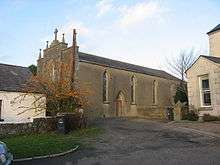
There is one church in Mornington, it is Roman Catholic, and was dedicated in 1989 as the Star of the Sea (Irish: Réalt ná Mara) with work completed in 1991. Since the establishment of the Laytown-Mornington parish in 1986 the curate in Mornington has acted in a supportive capacity to the parish priest in Laytown.
Recent curates of Mornington (since 1986) have been:
- Fr. Patrick Dillon, curate in St Mary's, Drogheda with special responsibility for the Mornington area 1974-1986, then 1986-1991 in Laytown-Mornington.
- Fr. Terence Toner, 1991-2001.
- Fr. Oliver Devine, 2001-2005.
- Fr. Willie Cleary, 2005-2015.
- Fr. Noel Weir, 2016-.
The present church was designed by Drogheda-based Turlough McKevitt Architects[25] and built by MJ Duffy & Sons Ltd. in the late-1980s. It replaced the old 'Star of the Sea' church in the centre of the original village.
The former church was gabled-fronted, its main entrance facing the West, with a date plaque for 1841 set above the door but also with a side entrance which was more commonly used. Inside on both sides of the main entrance, between the inner and outer doors, narrow curved stairs led up to the "Gallery". This was a slanting upper floor covering just over half of the church space. Here the choir sat and latecomers could sneak in after mass had started. A large confessional box was located on the right towards the rear under this floor. The church originally had the traditional ad orientem altar mounted into the East wall and following changes in the liturgy a later versus populum altar as well. A door to the sacristy led off to the right from the altar. Stained glass windows of the patron saints were transferred to the new church. The old church was built in the Gothic Revival style under the supervision of Thomas Hammond[26] of Drogheda in 1839-1841 for the Rev. John Donnellan of St. Mary's Parish[27] on the buff overlooking the bridge at Mornington were the Colpe stream enters the Boyne.
This original church site was also previously the location of a small Penal-era chapel and prior to that a pre-Reformation church listed in the ecclesiastical taxation (1302–06) of Pope Nicholas IV[28]. The latter was first recorded as being a ruin in 1622,[29] and part of its remains can still be found in the old graveyard adjoining. An earlier chapel at Mornington is mentioned c. 1192-1202 in a Llanthony Charter[30].
St. Patrick is said to have landed here,[31] Inbhear Colpa the mouth of the Boyne, tied up his boats and continued on his way to Slane along the south bank of the Boyne, though the church, and the former Church of Ireland church at Colpe, were traditionally dedicated to St. Columba.[32] This association can still be seen in the name of the local GAA Club, St. Colmcilles.
A former holy well dedicated to St. John is located in a marshy and wooded area known as "The Glen" near the new church. It is situated close to the Colpe stream at the base of a hill called Cnoc Bán.[33] Its pattern was observed, until suppressed by a local priest, "up to the turn of the [twentieth] century by people seeking cures for eye and ear ailments. Buttons, pieces of clothing and other personal items were hung on an elder bush overhanging the well. Local tradition claimed that the herbs growing around the well had the virtue of curing coughs, skin infections and deafness".[34] The well has a wall surround built into the side of the hill but is now choked with debris.
Current burials in the parish take place in Reilig Mhuire (Piltown Road Cemetery) which was opened in 1985.
Sport
Laytown and Bettystown Golf Club[35] is situated in Mornington townland.
St. Colmcilles, or Naomh Colmcille is the local GAA club. Their facilities are located at Páirc Uí Rís in Piltown, near Bettystown. Known as the "Blues" it was founded in 1971 with the merger of earlier clubs 'Star of the Sea' and 'Shallon' in the East Meath area. Previous local players were associated with St. Marys and Bettystown GFC.
Laytown and Bettystown Lawn Tennis Club, Golflinks Road, Bettystown, is also situated in Mornington.[36]
Boyne RFC was planning to build a state-of-the-art facility in Mornington but plans were suspended.
Education
There is one primary school split into a girls and boys school in Donacarney which service Mornington. They are Realt Na Mara BNS and Realt Na Mara GNS. There is also a secondary school called Colaiste na hInse, located in Laytown, which services Mornington and the east Meath area.
In 1837 a school of about 20 children was located in the 'small chapel at Mornington'. A Gothic style red-brick school which now serves as the local community centre was built in the 1870s at Donacarney Cross. Designed in 1872-3 by P.J. Dodd of Drogheda, with an extension in 1885, it features separate doors for girls and boys at the front of the building. Its twentieth-century replacement, with its water tower, was demolished to make the site available for the present-day schools in the early 2010s.
Artists
The area has inspired many artists over the years. Views of the estuary and its fishermen, the beach and the Maiden Tower appear as subjects in watercolour, illustration and oils by various artists including Alexander Williams, Nano Reid, Ithell Colquhoun and more recently Richard Moore.
The illustration "The lady's Finger & Maiden Tower, Co. of Eastmeath" an engraving based on a sketch by George Petrie appears as a plate in the antiquary Thomas Cromwell's Excursions through Ireland of 1820.
Mornington Strand
Mornington Strand consists of dunes, known locally since as least the mid-eighteenth century as The Burrows, and a wide sandy strand which extends south from the River Boyne towards Bettystown. It is a popular site for walkers and day-trippers in good weather. The links course of Laytown and Bettystown Golf Club is situated within the Mornington dune-system. There are areas of soft sand close to the River Boyne training walls; warning signs erected at Bettystown warn of the danger. The intertidal sand and mud flats, and the Mornington sand dune systems, are included within the Boyne Coast and Estuary Special Area of Conservation (SAC) which extends along the coast from Bettystown to Termonfeckin.[37] In recent times bodies of murder-victims relating to criminality have been found here in 2007[38] and 2013.[39]
Historic past
Mornington was a well-established 'manor'-settlement known as Marinerstown by the beginning of the 13th-century, and was known variously over time as Villa Roberti Marinarii[40] (1211[41]), Villa Marinarii, Maris[42], Marynerton, Marinerston by Colp, Marinerstown or Mornanton. The name was in use certainly by 1182 when Hugh de Lacy, Lord of Meath, just ten years after his enfeoffment with the lands of the Kingdom of Meath by Henry II, granted its tithes to support the new foundation of the Augustinian Abbey at Colpe, (a cell of Llanthony Priory in Monmouthshire). It took its name from Robert le Mariner, a Norman proprietor, who probably died before 1234 without heirs, as in that year Walter de Lacy, Lord of Meath, granted the lands of the "town of Mariners in Ireland near the port of Drogheda to God and the Abbey of St. Mary of Furness in England and the abbot and monks serving God there".[43] Despite these close links to the neighbouring and more extensive Manor of Colp it remained a separate manor up to the sixteenth-century with 'Marynerton' being listed amongst the Irish possessions of Furness Abbey and Llanthony at the Suppression of the Monasteries in 1536.[44] Around this time Henry Draycott (c. 1510–1572) an English-born Crown official and judge in sixteenth-century Ireland, who held a number of senior Government offices, became a substantial landowner in the Pale, with his principal estate at Mornington. He acquired many former church properties in the Dissolution and his descendants remained one of the significant families in the area.
The Maiden Tower, built in the sixteenth-century (see above), and the ruined tower-house castle at Donacarney Cross are the main surviving historic monuments in the area.
By 1603 Mornington was being considered part of the Civil Parish of Colpe. It appears as part of Colpe in the Civil Survey of 1654 and in Samuel Lewis's "Topographical Dictionary of Ireland" (1837) under Colpe, or Colpe-cum-Mornington.
Mornington was the scene of one of the actions in March 1642 during the raising of the Siege of Drogheda of 1641-42 as the garrison undertook raids into the locality to disrupt the Northern rebels under Sir Phelim O'Neill surrounding the town. The garrison found the previous year's harvest still in the fields and John D'Alton in his history of Drogheda quotes Dean Nicholas Bernard how:
Early on that morning [the 3rd of March] ... the forces under Colonel Wainman advanced hither, where they found the town abandoned, so that their whole work that day was to reap what was left, for which all sorts were permitted to go forth for pillage; the lanes so thickened with all sorts of grain, that the spring seemed to be harvest ... Such loads of corn were mounted on horses that upon the hills they looked like moving haggards, by which our great extremity was turned presently into plenty.[45]
The town of Drogheda then with great joy set to brewing the captured grain for beer "having drunk nothing but water for a week". In this raid they also burned:
A fair house of one Draycot (who by the rebels was newly created Viscount Mornington, for his merit in the cause) ... which was done the rather in a just revenge of his fraudulent disarming many of our soldiers as they were making hither from the bridge of Julianstown. His library, with what could be preserved from the fire, was brought in hither and sold us at very easy rates; a very large parchment manuscript of a old missal, consecrated to that church of Mornington, came to my hands, the loss of which I presume they have valued more that their houses.[46]
This missal and another book called the Black Book of Llanthony, both now lost, had previously belonged to the library of Henry Draycott[47].
The house is recorded in 1640 as the property of John Draycott of Mornanstowne and Valeran Weisley of Dingen, along with 308 acres.[48] Its ruins located on Church Road, were recorded as a large, irregularly-shaped building described in gothic lettering as a 'Ruin' on the 1836 ed. of the Ordnance Survey 6" map. It was believed locally to have been the site of a former monastery.
The Ozanam Home now sits on the site of 'Mornington House', Coney Hall, latterly the principal residence in the area and owned by the Brabazon family. A plaque dedicated to James Brabazon, Esq., who died in 1794, shows his links to the Earls of Meath, and is found on the ivy-covered wall of the early church in the old graveyard of Mornington. The family's association goes back to their seventeenth-century ancestor, a Captain James Brabazon who was wounded at the Battle of Aughrim on the Williamite side.[49] Another significant family in the area were the Weslies, later Earls of Mornington.
Title of "Earl of Mornington"
The title Earl of Mornington has been one of the greatest British aristocratic titles for centuries. Originally a British peerage title it is now a courtesy title. The current holder of the earldom is Arthur Darcy Wellesley (born 2010), the son of Arthur Gerald Wellesley, Marquess of Douro, and his wife Jemma, née Kidd, who is the sister of Jodie Kidd. The connection to Mornington of the Wellesley, Wesley, Weslie, or, Weisle family name goes back to at least the sixteenth-century, as Lewis says on the suppression of Colp Abbey a place called Weisle's Farm in Mornington was paying tithes to the Abbey. Gerald Weslie, late of Dangan, "Irish Papist", who died in 1603, is mentioned in an inquisition of 1624 as having been in possession of "the manor of Marinerstown or Mornanton counting two messages and 120A and of a capital fishery commonly called the lord's fishery".[50] Richard Colley, later Richard Wesley, 1st Baron Mornington inherited Dangan and Mornington in 1728. His son was the 1st Earl of Mornington, the father of Field-Marshal The 1st Duke of Wellington.
Use of the name Mornington in other contexts
The many Mornington places in Australia and across the world were named in honour of the second Earl, a brother of the Duke of Wellington.
This has led to its use for the Mornington Crescent game on I'm Sorry I Haven't a Clue taken from the Camden street Mornington Crescent, London also named for the second Earl.
The famous jockey Herbert Mornington, or Morny, Cannon was born the same day in 1873 that his father Tom Cannon won the Somersetshire Stakes at Bath on a colt named Mornington[51] and named after that event.
The name has also been used in the title of the play "Of Mornington" by Billy Roche, the play's revered snooker cue being handcrafted at the fictitious 'Beecher's of Mornington'.
See also
References
- ↑ de Courcy, J. 1996 The Liffey in Dublin. Dublin. 243
- ↑ http://www.meath.ie/Tourism/MeathsTownandVillages/Mornington/
- ↑ http://ie.geoview.info/maiden_tower_mornington_co_meath,49672081p
- ↑ This can be seen on the c. 1780 copy map by Daniel O'Brien of William Farriand's "The parishes of Killcarvan, Colpe and Julianstow, c. 1655" (see National Library of Ireland, MS. 716)
- ↑ [droghedamuseum.blogspot.ie droghedamuseum.blogspot.ie] Check
|url=value (help). Missing or empty|title=(help) - ↑ http://www.independent.ie/regionals/droghedaindependent/localnotes/local-outrage-at-damage-to-mornington-tower-27109980.html
- ↑ http://www.duchas.ie/en/cbes/5008904/4965574
- ↑ Ward, Michael. 'Mornington alias Marinerstown', in "Journal of the Old Drogheda Society, No. 6" (1989)', p66
- ↑ 16 perches are shown on the 1907 OSI 25 inch map
- ↑ Leo Boyle, Salmon Fishing on the Boyne River, A Brief Synopsis of the Boyne River Salmon Fishery, www.patburnsphotography.net, accessed 16/4/2014 quoted at http://www.whytes.ie/i6Main.asp?Auction=20140526&Lot=60
- ↑ Drogheda Independent 08/08/2012 Accessed at http://m.independent.ie/regionals/droghedaindependent/news/salmon-back-in-boyne-27168968.html
- ↑ Boyle, Leo. In "Remembering the Future: A Meath Coast Miscellany" edited by Brian Langan (Meath East Community Association, 2007), ISBN 0955766001
- ↑ Smylie, Mike. "Working the Irish Coast" (Nonsuch Ireland, 2009), ISBN 9781845889449, p. 226.
- ↑ Leo Boyle reported in Drogheda Independent, 8th September 2000. https://www.independent.ie/regionals/droghedaindependent/news/local-coastwatch-meeting-highlights-boyne-estuary-27124173.html
- ↑ Lewis, Samuel. A topographical dictionary of Ireland, under Colpe-cum-Mornington. 1837
- ↑ http://oar.marine.ie/bitstream/10793/488/1/Irish%20Fisheries%20Leaflet%20No%2063.pdf
- ↑ http://fish2fork.com/en_GB/news/news/collapsed-herring-fishery-certified-as-sustainable
- ↑ http://oireachtasdebates.oireachtas.ie/debates%20authoring/debateswebpack.nsf/takes/dail2001112100086?opendocument
- ↑ https://www.npws.ie/protected-sites/spa/004080
- ↑ https://www.npws.ie/sites/default/files/protected-sites/natura2000/NF004080.pdf
- ↑ https://www.npws.ie/protected-sites/sac/001957
- ↑ http://www.housing.gov.ie/sites/default/files/migrated-files/en/Foreshore/ApplicationsandDeterminations/DroghedaPortCompany/ApplicationDetails/FileDownLoad,30306,en.pdf
- ↑ "Archived copy" (PDF). Archived from the original (PDF) on 17 July 2013. Retrieved 4 August 2013.
- ↑ http://commuter.matthews.ie/images/Bettystown-Laytown-Dublin_Rev004.pdf
- ↑ http://www.mckevittarchitects.ie/mornington-church.php
- ↑ http://www.dia.ie/architects/view/2364/HAMMOND-THOMAS*#tab_biography
- ↑ See http://www.morningtonchurch.com/history.html
- ↑ Cal. doc. Ire. 5, 252
- ↑ Erlington, C. R. (ed.) 1847-64 The whole works of the most Reverend James Ussher. 17 vols. Hodges and Smith, Dublin 1847-64, 1, lxviii
- ↑ .The Irish chartularies of llanthony Prima and Secunda, ed. Eric St. John Brooks, Irish Manuscripts Commission (Dublin 1953). Charter XXVII [p.34]
- ↑ http://www.duchas.ie/en/cbes/5008904/4965574
- ↑ Ellison, Rev. C. C. 1971 Bishop Dopping’s Visitation Book 1682-5, Ríocht na Mídhe, 5, 1, P36. According to Dopping (1682-5) the church of Mornington or Marinerstown was dedicated to St. Columba but the graveyard was not enclosed
- ↑ Ward, Michael. 'Mornington alias Marinerstown', in "Journal of the Old Drogheda Society, No. 6" (1989)', p66
- ↑ Ward, Michael. 'Mornington alias Marinerstown', in "Journal of the Old Drogheda Society, No. 6" (1989)', p66
- ↑ http://www.landb.ie/
- ↑ http://www.laytownbettystownltc.com
- ↑ Bettystown/Laytown Beach Management Plan. Meath County Council, March 2017.
- ↑ http://www.irishtimes.com/news/murder-inquiry-after-beach-shooting-1.1293656
- ↑ http://m.independent.ie/irish-news/courts/man-charged-with-murder-of-body-found-on-meath-beach-29629068.html
- ↑ .Referenced in Riocht na Midhe journal (2016)
- ↑ .Brooks, E. St. John 1953 The Irish cartularies of Llanthony Prima and Secunda; edited from the MSS. in the Public Record Office, London. Irish Manuscripts Commission, Dublin. Charter LIX [p.75]
- ↑ Cal. doc. Ire. 5, 252
- ↑ Calendar of the Gormanston register, 8
- ↑ White, N.B. 1943 Extents of Irish monastic possessions, 1540-1541. Dublin. Irish Manuscripts Commission. P314, 319
- ↑ D'Alton, John. The History of Drogheda with its environs Vol. 2 P245. (Dublin, 1844)
- ↑ D'Alton, John. The History of Drogheda with its environs Vol 2. P245. (Dublin, 1844)
- ↑ P.6. O'Sullivan, W. 'Medieval Meath manuscripts' in Ríocht na Midhe 7:4 (1985-6).
- ↑ Simington, R.C. (ed.) 1940 The Civil survey, AD 1654-1656. Vol. V: county of Meath. Dublin. Irish Manuscripts Commission. P3
- ↑ http://www.turtlebunbury.com/history/history_family/hist_family_brabazon_disney.htm
- ↑ D'Alton, John. The History of Drogheda with its environs Vol 2. p450. (Dublin, 1844)
- ↑ Birmingham Daily Post (Birmingham, England), Thursday, 22 May 1873
External links
| Wikimedia Commons has media related to Mornington, County Meath. |