Ashbourne, County Meath
| Ashbourne Cill Dhéagláin | |
|---|---|
| Town | |
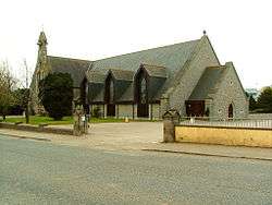 Church of the Immaculate Conception, Ashbourne | |
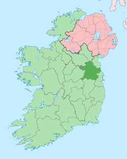
 Ashbourne Location in Ireland | |
| Coordinates: 53°30′43″N 6°23′53″W / 53.512°N 6.398°WCoordinates: 53°30′43″N 6°23′53″W / 53.512°N 6.398°W | |
| Country | Ireland |
| Province | Leinster |
| County | Meath |
| Elevation | 73 m (240 ft) |
| Population (2016)[1] | |
| • Urban | 12,679 |
| Time zone | UTC±0 (WET) |
| • Summer (DST) | UTC+1 (IST) |
| Eircode routing key | A84 |
| Telephone area code | +353(0)1 |
Ashbourne, historically called Killeglan or Kildeglan [2] (Irish: Cill Dhéagláin, meaning "Déaglán's church"), is a town in County Meath, Ireland. It is about 20 km north of Dublin close to the M2 motorway.
History
Archaeological excavations in the area around Ashbourne have revealed evidence of settlement back to neolithic times. In the townland of Rath, to the north of the town centre, a Bronze Age settlement was found during the construction of the M2 motorway. Excavations in the vicinity of the cemetery of Killegland revealed the extent of the early Christian settlement, with souterrains, house sites and a large enclosure centred around the remains of the church that is visible in the cemetery. This would link the townland name of Killegland - meaning Declan's Church - to pre-Patrician settlement in the area. Archaeological excavations on the site of Lidl supermarket revealed the original medieval town, with several house remains, associated field systems, fish traps and mill races.
Hugh de Lacy, Lord of Meath, set about building fortified houses, called mottes and baileys, in case the native Irish would regroup and attack. The remains of a motte and bailey can be found in Ratoath 5 km from Ashbourne.
Once settled, Hugh de Lacy divided the land among his army. A large portion at Killeglan was given to a family called Wafre in 1220. This family lived there until 1420, the last member of this family having built a tower house (a fortified house often called a castle). The castle and lands became the property of the Segrave family, who remained owners until 1649. The first of the family recorded in Meath, Richard Sydgrave, was Chief Baron of the Irish Exchequer 1423-5. They became one of the most influential and wealthy non-aristocratic families in Ireland during the 16th century, with two gaining the high political office of Chancellor of the Exchequer, while another became High Sheriff of Meath; Richard Segrave ( died 1598) and his son Patrick Segrave were both judges of the Court of Exchequer (Ireland).
However, their political power and possessions were removed during the religious wars of 1641 to 1650. Indeed, during the Cromwellian period, Oliver Cromwell's son, Henry, stayed for a time in Killeglan Castle. With the final subjugation of the native Irish after 1690, and the imposition of religious persecution in the Penal Laws, a new land-owner named Thomas Carter gained possession of the Killeglan lands. He did not live there, and the castle fell into dis-repair and eventually into ruin. The Carter family held high office in Irish politics during the 18th century but their fortunes waned in the early 19th century. When the Carter estates were sold in the 1840s, the Killegland lands were bought by Frederick Bourne.
Frederick Bourne was a rich entrepreneur who made his fortune from roads and transport. Before 1820 in Ireland roads were almost non-existent. Government regulations allowed for considerable spending on roads, and the subsequent improvements ensured greater post-coach services. Bourne owned a coach company and financed road-building, collecting revenue from tolls. He financed a ten-mile (old Irish miles) section of road from Dublin to Killegland. He decided to build a small town with an inn, a hotel and other small businesses to make money from travellers. He built this village near his ten-mile tollbooth and named the place after his favourite tree, and himself, i.e. Ash and Bourne. This began in 1820.
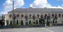
Bourne's idea was a success. However, by 1850 rail was taking business from the roadways, and the Bourne family fortune declined. In 1821 the population was 133, by 1841 it was 411. The Irish famine took a toll from 1845 to 1851, and the population declined. Frederick Bourne left his land at Killegland, and his village of Ashbourne, to his son Richard in 1844. Richard lived in the village, and his first home is now the Ashbourne House Hotel on Frederick Street. Later he built a modest house on Castle Street near where the last remains of the Wafre and Segrave tower house were. Richard married the daughter of a wealthy local family, Elizabeth Mangan, and had several children. The eldest, Thomas, became his father's heir and the last landlord of Ashbourne. He left Ireland and went to live in Northfleet, Kent, England, in 1899. The land was sold to the local tenants.
| Historical population | ||
|---|---|---|
| Year | Pop. | ±% |
| 1991 | 4,411 | — |
| 1996 | 4,999 | +13.3% |
| 2002 | 6,362 | +27.3% |
| 2006 | 8,528 | +34.0% |
| 2011 | 11,355 | +33.1% |
| 2016 | 12,679 | +11.7% |
Population
Ashbourne was a small village with a population under 400 until 1970. Then, in response to the growing population of nearby Dublin, a new scheme of houses was built in Ashbourne, based on the American open plan scheme rather than with fenced-off gardens. The population of the town was 8,528 as of the 2006 census, a 34% increase on the previous census in. 2002,The population in 2013 was recorded at 14,000 people approximately, making it Meath's second largest town after Navan and the largest town in the new Meath East Dáil constituency, which elects 3 TDs to the Dáil.
This growth was related to the construction of several new housing schemes, including several apartment blocks scattered throughout the town and a number of new housing estates. It's also coincided with a change in Ashbourne's demographics, with the 2006 census showing that over 12% of Ashbourne's population was born outside Ireland.[3] The Lithuanian community is the second largest minority in Ashbourne after people from the United Kingdom. Almost one fifth of all non-Irish born in the town are from Lithuania. Lithuanian language services are held in the Church of the Immaculate Conception. The Polish community in Ashbourne is the second-largest in Meath after Navan.
Public transport
Ashbourne is served by two public transport companies. Ashbourne Connect links the town with an express coach service direct to Dublin city centre and the southside of the city. The service is listed as 193 on the national journey planner. Bus Éireann provide a regular service (Route 103) from Beresford Place, Dublin, every 20 minutes. Some of these services continue on to Ratoath, Kilmoon Cross and Duleek. At the beginning of March 2010, a regular service to and from Navan via Dunshaughlin and Ratoath to Dublin Airport that had previously not passed through Ashbourne was rerouted to serve the Pillo Hotel at the northern end of the town, and to then go through the town to the airport and Dublin City University. The service (route 109A) runs every hour from early morning to late evening. The 104 service that ran from Ashbourne to Blanchardstown Shopping Centre was discontinued at the same time, and replaced by some of the 105 service being extended from Ratoath to also serve Ashbourne. Route 177, with a low frequency, also served Ashbourne from Dublin, and went on to Slane, Ardee and Monaghan, with extensions to Clones but was withdrawn in November 2013. There is also a very limited service (Route 107) from Kingscourt to Dublin via Ashbourne. In November 2013 routes 189 & 189A were introduced linking Ashbourne to Drogheda and Clogherhead.
Amenities
There is an 18-hole golf course, (founded 1991), on the outskirts of the town and several sports clubs in the town, including a Gaelic Athletic Association club, Donaghmore-Ashbourne, originally founded as Donaghmore in 1923 at the Wootton, and now with a new facility with pitches and clubhouse, with an indoor astro turf and two full-size Gaelic pitches opened at Killegland in 2006. There is also a rugby union team who play their matches at the Ashbourne rugby club (founded 1974) which has also has a new pitch and a small astro pitch which is sometimes used for 5-a-side soccer.
There are also a number of soccer teams (including Ashbourne United, & Killegland FC), a cricket club Ashbourne cricket club behind the community centre,[4] and a judo club.
There is a community centre, opened in 1981 and upgraded in 2017, which has a sports hall with a full size basketball court, 3 badminton courts, squash court, handball & racquet ball court, and changing facilities and meeting rooms. The community centre is used by sporting organisations, including the St Andrews athletics club who also have facilities in the Arkle Pavilion in Greenogue on the outskirts of Ashbourne, Ashbourne Archers,[5] who run archery training courses and weekly shoots in the indoor hall of Donaghmore Ashbourne GAA.
Fairyhouse Racecourse is located 10 km from Ashbourne. Tayto Park has been opened since 2010 and has approximately 50 acres of activities, including one of Europe's largest wooden roller coasters, which opened in June 2015. A baseball field opened in August 2015 and is home to Ashbourne Giants baseball club and Baseball Ireland.
Retail activities
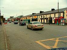
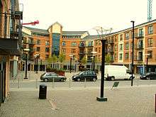
A series of shopping streets have been built as part of a scheme to give Ashbourne the type of retail centre more in keeping with other towns, these shopping facilities are in Ashbourne High Street and the crescent . Up until recently commercial development in the town was stifled given the fact that the town was bisected by a busy national primary route, the N2, on to which all commercial development was focused. This restricted the town's potential to attract high street retailers due to the a lack of suitable sites and the associated traffic hazards of the N2. In 2002, a local area plan for the town was completed which provides for the future development of Ashbourne. The plan provided for a major expansion of Ashbourne westward into the townland of Killegland adjoining the new N2 Ashbourne bypass. It led to the introduction of residential units, a retail park, community facilities and industrial units. The town is being planned westward, further into County Meath, as the Fingal County boundary is only 1.5 kilometres (0.9 mi) from the east side of the town, which decreases to approximately 600 metres (2,000 ft) at the north end of the town, in the townland of Rath.
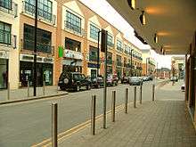
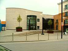
Of the streets developed in Ashbourne's "new" town centre, Killegland Street, has become a new commercial street containing a number of varied retail units along with a new library and council offices. Car parking in the town has been expanded thanks to both a large underground car park beneath Killegland Street (extending from Tesco to the Civic Offices) and a multi-storey car park above the retail units on the south end of the street.
Bridge Street is an existing street between the Broadmeadow River and the Ashbourne House Hotel which contained just three dwellings and no retail outlets eight years ago now has five shops, a large hotel, dozens of apartments and a supermarket there. This is typical of the high pace of development in Ashbourne in the past decade.

A large supermarket has opened a large store on the former Dardis & Dunns seed merchant site on the northern end of Frederick/Main Street as part of the Ashbourne Town Centre development and is accessible from both Frederick Street, across from Ashbourne's original town centre and Killegland Square, linking the new retail area to the established centre in the town.
Developments
Development is now being concentrated on the area west of Castle Street (known locally as Ned Nulty's Lane), a route which was completely realigned and widened in 2006 to allow motorists to avoid the new centre and reduce congestion, as well as providing a direct route from Garden City to Cluain Rí and areas like Brindley Park and Johnswood. 2007 also saw the opening of two new commercial ventures in the Rath, north of the town. Catalogue store Argos opened an Argos Extra outlet in the Ashbourne Retail Park in August 2007. The 148-room Pillo Hotel opened in April 2007 as the Ashbourne Marriott, but will re-brand in January 2018 as the Sheraton Ashbourne.[6]
Ashbourne Retail Park Ltd. applied for planning permission[7] on 9 March 2007 for an extension to the park, consisting of 4 additional double-height retail warehouse units, with a 1,000 seater cinema overhead as well as food and beverage outlets. Car parking was also to increase by another 210 spaces, with the entire extension containing almost 7,500 sq. m of floor area.
Cinema
The town's first cinema opened in Ashbourne Retail Park on 19 June 2009. The Sunday Tribune reported that the six-screen, 1,000-seat facility, which was Showtime Cinemas' first opening, has wall-to-wall screens, rocker seats, full digital projection and 3D capability.
Access
Ashbourne is linked to the M50 and Dublin City by 17 kilometres of motorway/high quality dual carriageway on the N2/M2 national primary route, which commences at junction 5 of the M50 motorway (13.5 km from Ashbourne). The road is a six-lane dual-carriageway from the M50 until exit 2, Cherryhound in Co. Dublin, where it becomes a motorway from there to the Rath roundabout, 1.5 km north of Ashbourne. The M2 incorporates a bypass of Ashbourne.
The N2 dual-carriageway, on its opening in 2006, was unique in Ireland as it was the first non-motorway road in the state to officially be granted national motorway speed limits of 120 km/h without any motorway restrictions. As a de facto motorway, many referred to this route as the M2 but this situation was regularised on 28 August 2009, when the section between exit 2 and the Rath roundabout north of Ashbourne will be redesignated as a motorway. The old N2, now re-designated the R135, had its speed limit reduced to 80 km/h in Co. Meath and 60 km/h in adjoining Fingal, much to the consternation of local motorists.
The N2/M2, which the Government announced in March 2005 would not be tolled, allows thousands of commuters and hauliers to avoid the town, which has become a major bottleneck for traffic heading south from County Donegal, County Londonderry, County Tyrone, County Monaghan, County Louth and the rest of County Meath. The South Ashbourne Interchange, a large junction taking traffic on and off the N2 near the Nine Mile Stone, allows non-stop transferral of traffic to and from Ashbourne and its new by-pass. Phase II of the M50 upgrade, opened in 2010, links the N2 to the M50 at exit 5 with a partial freeflow junction, meaning most traffic transferring from the M50 to the N2 and vice versa does not have to stop (traffic lights remain where traffic from the M50 southbound meets traffic from the N2 southbound).
Bus Éireann has not offered any express services using the new road, as expected when it first opened, and continue to use the old (R135) road for most services until Kilshane, where the R135 has an exit to the Dublin Airport Logistics Park and the N2. There is an informal, non-timetable Bus Éireann 103 service that occasionally runs via the M2 from Dublin to Ashbourne and the 107 Dublin-Navan-Kingscourt service also uses the M2 for an evening coach service at 5.40pm, leaving the M2 at Ashbourne South (exit 3) before continuing via the R135 and N2 north of Ashbourne towards Kentstown and Navan.
Dublin Bus use the N2 as far as Cherryhound (exit 2) for their 88N Nitelink service to Ashbourne
1916 Rising Monument
According to Ríocht na Mídhe, the journal of the Meath Archaeological and Historical Society, on 28 April 1916 a group of Fingal Volunteers estimated to number 45 men, under the command of Thomas Ashe, a national school teacher in Lusk, and second in command Richard Mulcahy, attacked the Royal Irish Constabulary barracks at Ashbourne. The barracks was usually manned by a sergeant and four constables but given the level of fighting in the Capital, reinforcements had been called in from surrounding barracks and so on the day of the attack there were 10 RIC men stationed there.
The rebels advanced on the barracks disarming two RIC men who were setting up a barricade outside the barracks. With these two men disarmed and captured, Ashe called on the remaining officers to surrender and immediately a siege situation turned into a shoot out. With little sign of capitulation on the RIC's part it is believed the use of a home-made grenade resulted in them offering to surrender by waving a white handkerchief.
However, before they could emerge the hoot of a car horn was heard to the north west. County Inspector Alexander Grey must have received word of the siege as he assembled between 54 and 67 men at Slane in 17 motorcars which were rushed to Ashbourne to put down the uprising. The rebels spread out and rushed along the Slane road to stop the convoy reaching Rath Cross and spreading out. The RIC reinforcements took heavy fire from the rebels from all sides. The firefight lasted many hours before volunteer reinforcements arrived from Boranstown. The RIC eventually surrendered to the volunteers. However given that the uprising in Dublin had been put down the Fingal volunteers eventually gave themselves up two days later. Thomas Ashe and his men were sentenced to death for their part in the attack, but this was later commuted to penal servitude for life.
The uprising at Ashbourne was not seen favourably at the time with the Meath Chronicle calling it a "tragic blunder". Navan Urban District Council passed resolutions of sympathy. A number of local catholic priests (Curragha & Ratoath) also spoke out against the attack. However condemnation turned into sympathy with the execution of the a number of prominent 1916 rebels who had fought in Dublin.
President of Ireland, Sean T. O'Kelly unveiled a memorial at Rath Cross Roads, Ashbourne,on Easter Sunday, 26 April 1959 which commemorates the Battle of Ashbourne. The story was covered on the front page of the Irish Times the next day. The memorial designed by Con O'Reilly and Peter Grant commemorates the Battle and John Crenigan and Thomas Rafferty who were killed. The monument has two images on one side the figure is in the form of Christ on the other side is a rebel. This monument is known locally as The Rath Cross.
It bears the following inscription;
ERECTED BY THE MEMBERS OF THE FINGAL BRIGADE OLD IRA TO COMMEMORATE THE VICTORIOUS BATTLE WHICH TOOK PLACE NEAR ASHBOURNE 28 APRIL 1916 WHERE VOLUNTEERS JOHN CRENIGAN & THOMAS RAFFERTY GAVE THEIR LIVES DESIGNED FROM THE POEM "LET ME CARRY YOUR CROSS FOR IRELAND LORD" COMPOSED BY THEIR LEADER COMMANDANT THOMAS ASHE
On Easter Monday 2016 the State staged a number of national commemoration events. Rath Cross was one of only four such venues outside of Dublin City to be so honoured.
On 25 September 2016 the monument was completed by the addition of two side figures. One representing the Volunteers (full uniform, the other a family)
Religion
The Roman Catholic parish of Ashbourne extends south to Newtown Commons, east to Greenoge, north to Rath and west to Harlockstown. The Church of the Immaculate Conception is located in the centre of the town. In 1981, the parish was joined to Donaghmore, which has its own church 2 km (1 mi) to the south-east of Ashbourne.
Sport
Ashbourne is home to Longhorns Rugby League Club which was formed in 2005 and plays its home matches at Ashbourne Rugby Club. Longhorns were All-Ireland Rugby League champions in 2017, and received an invitation from the Rugby Football League to enter the 2018 Challenge Cup. Longhorns were drawn away to fellow amateurs West Hull, of the National Conference League Premier Division. The Ashbourne team scored two tries in a 58-10 defeat on 28 January 2018.
People
- Patrick Donohoe, recipient of the Victoria Cross
- Johnny Logan - Eurovision Star
- Aengus Mac Grianna - RTÉ newsreader
- Brendan O'Carroll - Entertainer, known for Mrs. Brown's Boys
See also
References
- ↑ "Sapmap Area - Settlements - Ashbourne". Census 2016. Central Statistics Office. 2016. Retrieved 12 January 2018.
- ↑ Placenames Database of Ireland (see archival records)
- ↑ Irish Social Science Data Archive (14 June 2007). "Theme 2 - 1: Usually resident population by place of birth (Census 2006)". 2006 Small Area Population Statistics (SAPS). Central Statistics Office of Ireland. Archived from the original on 30 September 2007. Retrieved 2007-07-18.
- ↑ http://www.ashbournecricketclub.com
- ↑ http://www.ashbournearchers.com
- ↑ "New Hotels - Ireland" (HTML). New Hotels - Ireland. Starwood Hotels & Resorts. Retrieved 2017-05-30.
- ↑ "Meath County Council Planning Applications 05/03/07 to 11/03/07" (Doc file). Weekly Planning Permission Lists. Meath Tourism, Meath County Council. Retrieved 2007-07-18.
External links
| Wikimedia Commons has media related to Ashbourne, County Meath. |