M80 Ring Road, Melbourne
| M80 Ring Road Western Ring Road / Metropolitan Ring Road Victoria | |
|---|---|
|
| |
| General information | |
| Type | Freeway |
| Length | 37.75 km (23 mi) |
| Opened | 1992–1999 |
| Route number(s) |
|
| Former route number |
|
| Major junctions | |
| SW end | |
|
for full list see exits and interchanges. | |
| NE end | |
| Location(s) | |
| Major suburbs / towns | Sunshine West, Ardeer, Cairnlea, St. Albans, Keilor East, Keilor Park, Tullamarine, Airport West, Gowanbrae, Campbellfield, Thomastown, Bundoora |
| Highway system | |
The M80 Ring Road, more formally known as the Western Ring Road and Metropolitan Ring Road, is an urban freeway corridor in Melbourne, Australia. It connects the northern suburbs and western suburbs to other Victorian urban and rural freeways:
- Hume Freeway

- Tullamarine Freeway

- Calder Freeway

- Western Freeway

- West Gate Freeway and Princes Freeway

It is linked to the eastern suburbs by the shorter Metropolitan Ring Road; the two are collectively called 'the Ring Road', and are generally considered together on traffic reports. It is signed as route M80 for its entire length.
The road relieves freight traffic from Sydney Road, Pascoe Vale Road and Geelong Road and funnels them to the freeways. With connections to every major interstate and regional freeways, it has encouraged both industrial and residential growth in Melbourne's western suburbs.
Over the past few years there have been discussions about extending the Metropolitan Ring Road from Greensborough Road and tunnelling it under Greensborough and going through the Banyule Flats and connecting to the Eastern Freeway at Bulleen.
A study has been initiated by VicRoads to supplement the Western Ring Road with an Outer Metropolitan Ring Road.
A major upgrade of the entire route commenced in 2009 and was partially completed in 2014, and includes widening and a Freeway Management System. Construction on the Sunshine Avenue to Calder Freeway section commenced on 2 October 2016 and is expected to be completed in late 2018. The upgrade of the Princes Freeway to Western Highway section is expected to begin construction in early 2018 and be completed in late 2020. The upgrades of Plenty Road to Greensborough Highway and Sydney Road to Edgar Road sections are expected to begin construction in 2019 and be complete by late 2021.
History
The Ring Road project was proposed as part of the 1969 Melbourne Transportation Plan (F3, F5 & F7 Freeway corridors) and has documented in almost every edition of the Melway Street Directory since that time. Construction of the Western Ring Road began in 1989 with work on the Broadmeadows section, and was completed with the final link between the Calder and Tullamarine Freeways. Under the Keating Commonwealth government, a total $555 million was provided by the Federal Government for the Western Ring Road, with a $76 million contribution from the Victorian Government.
Completed in stages, the freeway opened to traffic as follows:
- 1992 – Broadmeadows section – Tullamarine Freeway to Pascoe Vale Road opened to traffic on 20 September 1992.[1]
- 1993 – Broadmeadows section – The second stage of the Broadmeadows section, between Pascoe Vale Road and Sydney Road was opened to traffic on 7 July 1993. This section includes the Jacana Tunnel, which won an Excellence Award in the Public Works category awards by the Institution of Engineers Australia.[1]
- 1994 – Greenborough Bypass to Plenty Road. This 2.5 km section opened April 1994, at a cost of $A15.5m.[2]
- 1995 – Ballarat Road to Keilor Park Drive opened July 1995.[3] The official opening of the E J Whitten Bridge by the Premier of Victoria occurred on 18 August 1995.[4]
- 1996 – Boundary Road to Ballarat Road opened 6 March 1996.[4]
- 1997 – Calder Freeway to Tullamarine Freeway. This final section of the Western Ring Road was opened on 5 June 1997. The ‘Western Ring Road’ refers to the M80 Ring Road between Sydney Road, Campbellfield and the West Gate/Princes Freeway interchange at Altona.[5]
- 1999 – Sydney Road to Dalton Road. This 6 km final section of the Metropolitan Ring Road opened to traffic on 20 August 1999, at a cost of $A140m. The ‘Metropolitan Ring Road’ refers to the section of the M80 Ring Road between Sydney Road and the Greensborough Highway.[6]
The project is generally divided into 3 sections:
- Western Ring Road: This is the section between the West Gate Freeway and the Hume Freeway. It is currently named and signed as M80 – "Western Ring Road" for its entire length. This section was previously a 'National Highway' until 2013 and was signed with a National Highway M80 shield from Western Highway (Ballarat Road) to Hume Highway (Sydney Road). It was changed to 'state route' M80, for continuity with the rest of the freeway and to complement all infrastructure and signage with the 2009 to 2014 upgrade (the "National Highway" function and its shields are slowly being phased-out across Victoria following newer federal government initiatives and programs such as AusLink or the Nation Building Program, though some routes will retain its former signage until an update is necessary).
- Northern Ring Road: This section is currently named and signed as M80 – Metropolitan Ring Road although many people do not know that is its current official title. It is located between the Hume Freeway and the Greensborough Highway.
- Non-Official "M80 Ring Road" Road/Route:
Eastern Ring Road (M3): This 39 km section, originally named "[Proposed] Mitcham-Frankston Freeway" by Melway, officially named EastLink and opened to the public on 29 June 2008, connects the Eastern Freeway to the Frankston Freeway. Originally planned to be free from tolls and partially funded by the Federal Government, the Victorian Government under Steve Bracks broke its election promise and pushed for the road to be tolled. (The opening included the completion of the separate Ringwood Bypass so that the route loops around Ringwood back to Maroondah Highway rather than 'bypassing' the north of the town.)
2009–2021 Upgrade
Initial Upgrading and widening works of the Western and Metropolitan Ring Roads was carried out between 2009 and 2014, funded by the Federal Government Auslink 2 program.[7]
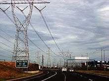
The entire length of the Freeway is being upgraded, within individual sections over a number of years. Initial work started in 2009 and work on some sections were completed in 2014. Along with the $2.25 billion upgrade, is a new 'Freeway Management System' that includes Ramp Signals (Traffic Lights located within on-ramps), overhead lane signs (electronic variable speed limits and lane symbols) & overhead electronic message boards; along with various new CCTV cameras and 'intelligent' sensors underground (to detect freeway congestion for signals). This system will be controlled and managed by VicRoads. The entire upgrade is being jointly funded by the State Government of Victoria (Australia) and Federal Government of Australia, being fully controlled and operated by the State's 'Road & Traffic Authority' – VicRoads. This is the most major and expensive road upgrade in Victoria, since the M1 (Monash Freeway / Citylink) upgrade was completed in 2007/2008.
In late 2009, construction began on the upgrade and widening of 38 kilometres (24 mi) of the M80 from Princes Freeway at Laverton North to the Greensborough Highway at Greensborough. The first stage involved widening the 9.7 km (6.0 mi) stretch from Calder Freeway to Sydney Road from 6 to 8 lanes.[8]
In mid 2015 to early 2016, the state and federal governments had announced A$300 million in funding to upgrade the remaining sections along the ring road, previously allocated to the now defunct East West Link road project. Construction on the Sunshine Avenue to Calder Freeway section commenced on 2 October 2016 and is expected to be completed in late 2018. The upgrade of the Princes Freeway to Western Highway section is expected to begin construction in early 2018 and be completed in late 2020. The upgrades of Plenty Road to Greensborough Highway and Sydney Road to Edgar Road sections are expected to begin construction in 2019 and be complete in early–late 2021. The full M80 Ring Road upgrade is anticipated to be complete by late 2021.
VicRoads had originally produced an official "M80 Upgrade Website" with links to a newly created site showing video simulations, maps and 'what's new' on the freeway, for already or nearly completed sections. This website is no longer available for access online.[9]
Missing section
Currently, the easternmost point of the Northern Ring Road terminates at Greensborough at the Greensborough Bypass.
If the road is built, it would run through areas that are environmentally and politically sensitive, such as Viewbank, Banyule Flats, Eltham, Templestowe or Warrandyte. The link to the east may well have to be provided by other means, such as the proposed tunnel to connect the Eastern Freeway with Melbourne's west.
Another possible route for the freeway has been suggested that would result in existing transmission line corridors being utilized.[10] The official reservation for the extension ends at Ryans Road in Eltham North, but these transmission line corridors could be used to carry the freeway through to Eastlink in Ringwood. Environmental impacts would still be a problem including noise, pollution, possible destruction of vegetation and the interruption of wildlife crossings. Less opposition from local politicians and the public would be likely if the much more expensive option of tunnelling is chosen (if the extension does actually proceed).
If completed it will provide a unofficial circumferential route around Melbourne starting from Altona and ending in Frankston. The resulting beltway will be similar to the size and scope of Sydney's Orbital Motorway and would enable traffic to transit between the Hume and Calder Highways and Melbourne's outer east without having to cross Melbourne's inner suburbs.
On 7 July 2008 it was announced by then Premier John Brumby that the completion of the Missing Section was again being considered by the Victorian State Government as part of a wider plan to deal with Melbourne's traffic problems.[11] A new freeway through some of the city's most environmentally sensitive areas is among a series of proposals considered in the plan. Environmental concerns about building the road through the green wedge and the disruption of communities in the area have been raised.
In December 2016, Premier Daniel Andrews announced plans for extending the freeway. The project is expected to cost around $10 billion. Community consultation will start in 2017 and construction is expected to begin in 2019.
Purpose
Much controversy surrounds the Metropolitan Ring Road project in Melbourne in many different topics including; environmental, economical, social, private & public transportation and both positive and negative aspects are well represented for each topic by many people and groups small and large. This has led to heavy debate in all areas of society in Melbourne from political and media to general public views and conversations.
The road serves various uses:
- integrating the metropolitan area by linking middle and outer suburbs
- assisting circumferential travel through the middle suburbs as opportunities for cross town movement are limited
- linking the growing populations in the south-east and west suburbs to jobs and economic opportunities throughout the metropolitan area
- providing access to Melbourne Airport, the ports of Melbourne and Geelong, and rail freight terminals, from all parts of Melbourne and from across the State
- provide good access to the whole of the Melbourne metropolitan area to and from country Victoria and interstate.
Route
The Western Ring Road is 28 km long, and the Metropolitan Ring Road is 10 km long, for a total length of 38 km. The freeway changes its name at the Hume Freeway (Craigieburn Bypass). The freeway had previously changed its name at Sydney Road, but that point shifted with the opening of the Bypass, extending the Western Ring Road by 2 km.
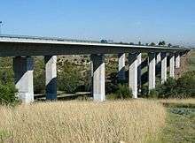
A major feature of the road is the EJ Whitten Bridge over the Maribyrnong River, named after Australian rules football player Ted Whitten.
The road is divided, carries between two and four lanes of traffic in either direction, and has a non-peak speed limit of 100 km/h for almost its entire length; between Greensborough Bypass and Plenty Road, the speed limit drops to 80 km/h (formerly 90 km/h before freeway works completed). The Western Ring Road between the Western Highway and the Tullamarine Freeway is configured with variable speed limits, which can vary between 60 km/h and 100 km/h depending upon traffic conditions.
Standard travel time for the M80 Ring Road is 25 minutes (19 minutes on the Western Ring Road and 6 minutes on the Metropolitan Ring Road) in both directions. However, peak period freeway travel times typically vary between 30 and 45 minutes in each direction, unless there are significant incidents, which can stretch travel times from 50 minutes to beyond one hour.
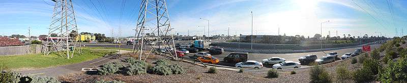
During peak periods, the freeway is generally congested (as of 2017) at the following sections:
Altona Bound (inbound):
- Morning:
– Calder Freeway to Keilor Park Dve; Western Freeway to West Gate Freeway / Princes Freeway
- Afternoon:
– Airport Drive to Keilor Park Drive
Greensborough Bound (Outbound):
- Morning:
– Furlong Road to Sunshine Avenue
- Afternoon:
– West Gate Freeway / Princes Freeway to Boundary Road; Ballarat to EJ Whitten Bridge; approaching Plenty Road.
The M80 Ring Road upgrade between 2009–2013, significantly reduced congestion points. Particularly in both directions between the Tullamarine Fwy and Sydney Rd.
Exits and interchanges
| Location[12] | km[12] | mi | Destinations | Notes | |
|---|---|---|---|---|---|
| Laverton North | 0.00 | 0.00 | |||
| Derrimut | 1.24 | 0.77 | |||
| 2 | 1.2 | 7-Eleven service centre | |||
| 3 | 1.9 |
| |||
| Ardeer | 5 | 3.1 | Kororoit Creek | ||
| St Albans | 7 | 4.3 | Furlong Road – St Albans, Sunshine | ||
| 9 | 5.6 | ||||
| Keilor East | 10 | 6.2 | Maribyrnong River | ||
| 13 | 8.1 | ||||
| Keilor Park | 15 | 9.3 | No access southbound form Altona-bound Ring Road and from northbound to Greensborough-bound Ring Road. | ||
| Tullamarine | 17 | 11 | Airport Drive/Westfield Drive – Tullamarine, Airport West | ||
| 19 | 12 | No access to city-bound from Greensborough-bound Ring Road and from airport-bound to Altona-bound Ring Road. Melrose Drive has Altona-bound exit and Greensborough-bound entrance only. | |||
| Jacana | 21 | 13 | Moonee Ponds Creek | ||
| 22 | 14 | Greensborough-bound exit and Altona-bound entrance only | |||
| Fawkner | 24 | 15 | |||
| Thomastown | 26 | 16 | Western Ring Road / Metropolitan Ring Road | ||
| 28 | 17 | Edgars Road – Thomastown, Epping | |||
| 30 | 19 | Dalton Road – Epping, Reservoir | |||
| Bundoora | 33 | 21 | |||
| Greensborough | 37.75 | 23.46 | |||
1.000 mi = 1.609 km; 1.000 km = 0.621 mi
| |||||
See also
References
- 1 2 Vicroads. Vicroads Annual Report 1992-93, Kew, Victoria: Vicroads, 1993, p. 39
- ↑ Vicroads. Vicroads Annual Report 1993-94, Kew, Victoria: Vicroads, 1994, p. 11
- ↑ Paul Mees (2001). "The short term effects of Melbourne's Western Ring Road" (PDF). Papers of 24th ATRF. Retrieved 8 May 2013.
- 1 2 Vicroads. Vicroads Annual Report 1995-96, Kew, Victoria: Vicroads, 1996, p. 14
- ↑ Vicroads. Vicroads Annual Report 1996-97, Kew, Victoria: Vicroads, 1997, p. 14
- ↑ Vicroads. Vicroads Annual Report 2000-01, Kew, Victoria: Vicroads, 2000, p. 27
- ↑ AusLink 2: Western Ring Road
- ↑ "Archived copy" (PDF). Archived from the original (PDF) on 6 January 2010. Retrieved 2011-04-08.
- ↑ http://www.vicroads.vic.gov.au/Home/M80Upgrade/?fullsite=true
- ↑ The Age 9 July 2008—'Missing link' may drive MPs from power
- ↑ The Age 8 July 2008—New orbital freeway plan for city
- 1 2 Google (7 January 2017). "M80 Ring Road" (Map). Google Maps. Google. Retrieved 7 January 2017.
Road infrastructure in Melbourne | |
|---|---|
| Freeways | |
| Highways |
|
| Bypasses | |
| Bridges and tunnels | |
| Proposals | |
| |