Central Seberang Perai District
| Central Seberang Perai District | |
|---|---|
|
| |
| Daerah Seberang Perai Tengah | |
| Other transcription(s) | |
| • Chinese | 威中县 |
| • Tamil | மத்திய செபாராங் பிறை |
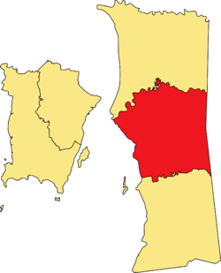 Location of Central Seberang Perai District in Penang | |
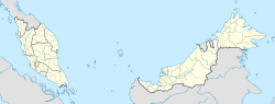 Central Seberang Perai District Location of Central Seberang Perai District in Malaysia | |
| Coordinates: 5°21′N 100°28′E / 5.350°N 100.467°ECoordinates: 5°21′N 100°28′E / 5.350°N 100.467°E | |
| Country |
|
| State |
|
| Seat | Bukit Mertajam |
| Local area government(s) | Seberang Perai Municipal Council |
| Government | |
| • District officer | Ali Sebran |
| Area[1] | |
| • Total | 238 km2 (92 sq mi) |
| Population (2010)[2] | |
| • Total | 371,975 |
| • Estimate (2015)[1] | 395,100 |
| • Density | 1,600/km2 (4,000/sq mi) |
| Time zone | UTC+8 (MST) |
| • Summer (DST) | UTC+8 (Not observed) |
| Postcode | 13500-14100 |
| Calling code | +6-043 to +6-045 |
| Vehicle registration plates | P |
The Central Seberang Perai District (SPT; Malay: Daerah Seberang Perai Tengah) is a district in the state of Penang, Malaysia. It covers an area of 238 square kilometres, and had a population of 371,975 at the 2010 Census .[2] The district is bordered by Perai River which separates North Seberang Perai in the north, Junjong River which separates South Seberang Perai in the south, Kedah state border in the east and South Channel which separates Penang Island. Juru River also flows through the district. The capital of this district is Bukit Mertajam. Other localities that are situated in Central Seberang Perai include Permatang Pauh, Penanti, Bukit Tengah, Bukit Minyak, Juru, Alma, Machang Bubok and Permatang Tinggi. The entertainment, eatery and automobile venue of Autocity is also located in this district. Heavy industrial areas cover most parts of Central Seberang Perai.
Administrative divisions
SPT District is divided into 21 mukims and also consist of 4 towns which are Bukit Mertajam, Perai, Bandar Perda and Seberang Jaya.[3][4][5]
| Mukim | Area | Mukim | Area |
|---|---|---|---|
| 1 | Seberang Jaya | 12 | Juru |
| 2 | Sama Gagah | 13 | Bukit Minyak Industrial Zone |
| 3 | Permatang Pasir | 14 | Permatang Tinggi |
| 4 | Permatang Pauh | 15 | Alma |
| 5 | Kubang Semang | 16 | Machang Bubok |
| 6 | Taman Pauh | 17 | Mertajam Hill |
| 7 | Bandar Perda | 18 | Mengkuang |
| 8 | Tanah Liat | 19 | Ara Kuda |
| 9 | Berapit | 20 | Guar Perahu |
| 10 | Jalan Betek (administrative centre) | 21 | Bukit Jelutong |
| 11 | Bukit Tengah | ||
| The Bukit Mertajam proper mukim are in blue colour. | |||
Demographics
The following is based on Department of Statistics Malaysia 2010 census.[2]
| Ethnicity | 2010 | |
|---|---|---|
| Population | Percentage | |
| Malays | 170693 | 45.89% |
| Other Bumiputeras | 1413 | 0.38% |
| Chinese | 133863 | 35.99% |
| Indians | 35158 | 9.45% |
| Others | 1358 | 0.37% |
| Malaysian total | 342485 | 92.07% |
| Non-Malaysian | 29490 | 7.93% |
| Total | 371975 | 100.00% |
Federal Parliament and State Assembly Seats
List of Central Seberang Perai district representatives in the Federal Parliament (Dewan Rakyat)
| Parliament | Seat Name | Member of Parliament | Party |
|---|---|---|---|
| P44 | Permatang Pauh | Nurul Izzah Anwar | Pakatan Harapan (PKR) |
| P45 | Bukit Mertajam | Steven Sim Chee Keong | Pakatan Harapan (DAP) |
| P46 | Batu Kawan | Kasthuriraani a/p Patto | Pakatan Harapan (DAP) |
List of Central Seberang Perai district representatives in the State Legislative Assembly of Penang.
| Parliament | State | Seat Name | State Assemblyman | Party |
|---|---|---|---|---|
| P44 | N10 | Seberang Jaya | Afif Bahardin | Pakatan Harapan (PKR) |
| P44 | N11 | Permatang Pasir | Faiz Fadzil | Pakatan Harapan (AMANAH) |
| P44 | N12 | Penanti | Norlela Ariffin | Pakatan Harapan (PKR) |
| P45 | N13 | Berapit | Heng Lee Lee | Pakatan Harapan (DAP) |
| P45 | N14 | Machang Bubok | Lee Khai Loon | Pakatan Harapan (PKR) |
| P45 | N15 | Padang Lalang | Chong Eng | Pakatan Harapan (DAP) |
| P46 | N16 | Perai | Ramasamy a/l Palanisamy | Pakatan Harapan (DAP) |
| P46 | N17 | Bukit Tengah | Gooi Hsiao Leung | Pakatan Harapan (PKR) |
See also
| Wikimedia Commons has media related to Central Seberang Perai. |
References
- 1 2 "2017 Q2 statistics" (PDF). Penang Institute.
- 1 2 3 "Population Distribution and Basic Demographic Characteristics, 2010" (PDF). Department of Statistics, Malaysia. Archived from the original (PDF) on 22 May 2014. Retrieved 19 April 2012.
- ↑ "Latar Belakang". spt.penang.gov.my.
- ↑ "UPI – Unique Parcel Identifier". myliis3.mygeoportal.gov.my.
- ↑ "Peta Daerah". spt.penang.gov.my.
External links
- Official Website of Central Seberang Perai Land & District Office
- Official Website of Seberang Perai Municipal Council
Capital: George Town | |||||||||||||||
| Topics | |||||||||||||||
| Society | |||||||||||||||
| Administrative divisions |
| ||||||||||||||
| |||||||||||||||