Biri, Northern Samar
| Biri | |
|---|---|
| Municipality | |
| Municipality of Biri | |
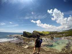 Bel-at and Tidal pool part of Biri Rock Formation | |
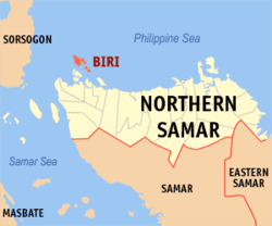 Map of Northern Samar with Biri highlighted | |
.svg.png) Biri Location within the Philippines | |
| Coordinates: 12°40′N 124°23′E / 12.67°N 124.38°ECoordinates: 12°40′N 124°23′E / 12.67°N 124.38°E | |
| Country |
|
| Region | Eastern Visayas (Region VIII) |
| Province | Northern Samar |
| District | 1st District |
| Barangays | 15 (see Barangays) |
| Government [1] | |
| • Type | Sangguniang Bayan |
| • Mayor | Antonio B. Delos Reyes, Jr. |
| • Vice Mayor | Warren Borcelo |
| • Electorate | 7,414 voters (2016) |
| Area [2] | |
| • Total | 24.62 km2 (9.51 sq mi) |
| Population (2015 census)[3] | |
| • Total | 11,767 |
| • Density | 480/km2 (1,200/sq mi) |
| Time zone | UTC+8 (PST) |
| ZIP code | 6410 |
| PSGC | 084802000 |
| IDD : area code | +63 (0)55 |
| Climate type | Tropical rainforest climate |
| Income class | 5th municipal income class |
| Revenue (₱) | 44,155,528.00 (2016) |
| Native languages |
Waray Tagalog |
Biri, officially the Municipality of Biri, is a 5th class municipality in the province of Northern Samar, Philippines. According to the 2015 census, it has a population of 11,767 people.[3]
The municipality is facing Pacific Ocean to the east and San Bernardino Strait to the west. It consists of several islands off the northern coast of Samar Island, the largest of which is Biri Island. Other larger islands are Talisay, Magasang, and Cagnipa. Biri Island is notable for a large number of unusual rock formations along the northern shore, facing the Philippine Sea. It is included in the marine protected area known as Biri Larosa Protected Landscape and Seascape.
The archipelagic town is also known for its inakob, a traditional Waray dish made by first cooking grated root crops (gabi) with coconut milk, condensed milk, eggs, brown sugar, and an herb called anuv. Once cooked, the grated gabi is put inside gabi shells which have been peeled. The dish is then boiled with coconut milk. The dish is traditionally eaten hot by the people of Biri during the rainy months.[4]
Barangays
Biri is politically subdivided into 8 barangays.
- Poblacion (Biri)
- MacArthur
- Kauswagan (Basud)
- Pio Del Pilar
- Progress or Talisay
- San Antonio
- San Pedro
- Santo Niño (Palhugan)
Demographics
| Population census of Biri | ||||||||||||||||||||||||||||||||||
|---|---|---|---|---|---|---|---|---|---|---|---|---|---|---|---|---|---|---|---|---|---|---|---|---|---|---|---|---|---|---|---|---|---|---|
|
| |||||||||||||||||||||||||||||||||
| Source: Philippine Statistics Authority[3] [5] [6] [7] | ||||||||||||||||||||||||||||||||||
Mangrove reforestation
In 2007, the Community-Based Mangrove Protection and Management project was implemented in Biri, funded by the Philippine Tropical Forest Conservation Foundation (PTFCF). The project aimed to contribute to the regeneration of the mangrove ecosystem by establishing a community-based mangrove management system. The project covered protection of 546 hectares and enhancement planting in 39 hectares. As of 2013, it has been expanded to all eight barangays in Biri.[8]
Biri Initiative Org.
In 2012, a non-profit organization, Biri Initiative Org., was registered with the Philippine Securities and Exchange Commission. Its main objectives are to restore areas of coral reef damaged by illegal fishing methods, promote sustainable and environment-friendly methods of fishing, and encourage opportunities for alternative livelihoods, particularly for women.[9]
References
- ↑ "Municipality". Quezon City, Philippines: Department of the Interior and Local Government. Retrieved 31 May 2013.
- ↑ "Province: Northern Samar". PSGC Interactive. Quezon City, Philippines: Philippine Statistics Authority. Retrieved 12 November 2016.
- 1 2 3 Census of Population (2015). "Region VIII (Eastern Visayas)". Total Population by Province, City, Municipality and Barangay. PSA. Retrieved 20 June 2016.
- ↑ https://www.youtube.com/watch?v=7Hw77F_P7Go
- ↑ Census of Population and Housing (2010). "Region VIII (Eastern Visayas)". Total Population by Province, City, Municipality and Barangay. NSO. Retrieved 29 June 2016.
- ↑ Censuses of Population (1903–2007). "Region VIII (Eastern Visayas)". Table 1. Population Enumerated in Various Censuses by Province/Highly Urbanized City: 1903 to 2007. NSO.
- ↑ "Province of Northern Samar". Municipality Population Data. Local Water Utilities Administration Research Division. Retrieved 17 December 2016.
- ↑ "Philippine Tropical Forest Conservation Foundation". Retrieved 22 September 2013.
- ↑ "Biri Initiative". Retrieved 22 September 2013.
External links
| Wikimedia Commons has media related to Biri, Northern Samar. |
| Wikivoyage has a travel guide for Biri, Northern Samar. |
- Philippine Standard Geographic Code
- Philippine Census Information
- Local Governance Performance Management System
Places adjacent to Biri, Northern Samar | |
|---|---|