Magnetic Island
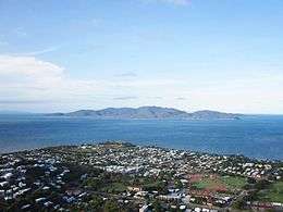 The View of Magnetic Island from the Castle Hill, Townsville | |
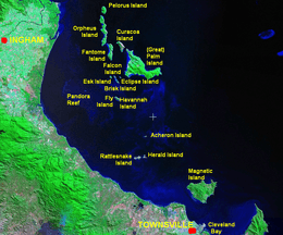 Palm Islands location | |
| Geography | |
|---|---|
| Location | Coral Sea |
| Area | 52 km2 (20 sq mi) |
| Highest elevation | 497 m (1,631 ft) |
| Highest point | Mount Cook |
| Administration | |
|
Australia | |
| Demographics | |
| Population | 2,107 (2006) |
| Pop. density | 40 /km2 (100 /sq mi) |
Magnetic Island is an island 8 kilometres (5.0 mi) offshore from the city of Townsville, Queensland, Australia. This 52 km2 (20.1 sq mi) mountainous island in Cleveland Bay has effectively become a suburb of Townsville, with 2,107 permanent residents.[1] The island is accessible from Townsville Breakwater to Nelly Bay Harbour by ferry. There is a large 27 km2 (10.4 sq mi) National Park and bird sanctuary and walking tracks can be taken between the populated bays and to a number of tourist destinations such as the World War II forts.
The island has long become established as a holiday destination with many hotels and several resorts in operation to cater for all levels of service. The public facilities and infrastructure on the island are managed by the Townsville City Council. The island is part of the electoral district of Townsville in the Legislative Assembly of Queensland. The island is also part of the Federal seat of Herbert, which is represented by Cathy O'Toole.
In 2009 as part of the Q150 celebrations, the Magnetic Island was announced as one of the Q150 Icons of Queensland for its role as a "Natural attraction".[2]
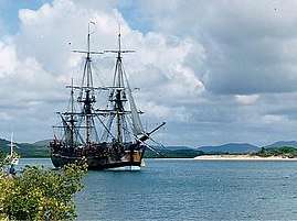
The wreckage of SS City of Adelaide is located not far off the shore of the island and is a popular tourist attraction.[3]
Naming
The name of the island came about because of the apparent "magnetic" effect it had on the ship's compass of Captain Cook as he passed the island when sailing up the east coast of Australia in 1770.[4] People have since explored the general area of Magnetic Island with various instruments to discover what might have caused the effect that Cook reported, but nothing has been discovered. The island's mysterious magnetic effect is the basis for the 2015 speculative fiction novel 'A Tango with the Dragon.' The local name for the island is "Maggie Isle",[5] "Maggie Island",[6] or "The Island".
Natural heritage
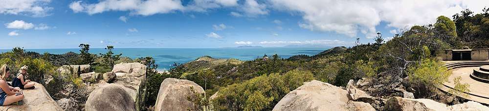
The island is a haven for wildlife. 54% of the island is Magnetic Island National Park, which is mostly located on the steep hilly interior and rugged north-western side. The highest point on the island is Mount Cook reaching 497 m (1,631 ft) above sea level.[4]

Magnetic Island is famous for its angling opportunities. Fish around the island include: blue marlin, black marlin, sailfish, mackerel, wahoo, giant trevally, dogtooth tuna, coral trout, mahi-mahi, tuna, red emperor and sea perch.
As of 2013, there are over 800 koalas estimated to be present on the island; this population represents the northern limit of their geographic range.[7]
The pressure of coastal development has, in recent years, begun to make a significant impact on the island, which lies in the World Heritage listed Great Barrier Reef Marine Park. At present many millions of dollars in development are planned for the island and the impact of these has led to considerable opposition from some residents who fear the effects this development will have on the environmental values of Magnetic's lowlands which are not protected by the national park; these areas represent 20% of the whole island, and of this 20%, most is freehold land and is already developed.
History
Pre-European settlement
Yunbenun, as Magnetic Island was known by the island's traditional inhabitants, had a transient population of Australian Aborigines well before European exploration of the area. They were known to have seasonal camps at a number of bays, and travelled between the island and mainland using canoes. A number of Aboriginal burial sites are said to exist on the island, but have so far not been identified. Aboriginal middens and cave drawings can still be found in a number of bays around Magnetic Island. Folklore of the local Wulguru tribe recounts a long association with the island and annual migrations to the mainland to avoid expeditions of head-hunters from Papua New Guinea and the Torres Strait, which used the northern trade winds to travel south along the Queensland coast. This head-hunting nearly ceased following the arrival of missionaries, led by Samuel MacFarlane to the Torres Straits in 1871.[8]
The first European accounts of the island come from Captain James Cook who, in 1770, while navigating the Australian coast, called the island Magnetical Island, as a magnetic pull interfering with his vessel's compass appeared to emanate from the island. J.M. Black, funded by Robert Towns, founded the township of Townsville on the mainland nearby. As Townsville developed though the mid-19th century, Magnetic Island became a valuable location for the gathering of hoop pine and granite, the latter of which was used in the reclamation of land for the Port of Townsville, and for construction of Townsville's Customs House.[8]
European settlement and development

Picnic Bay was named after its popularity as a picnic spot for European tourists from the mainland during the 19th century, before Magnetic Island was first inhabited by Europeans. In the mid-19th century the island became a popular location for the collection of stone and coral needed for development on the mainland. In 1875, the island was set aside as a quarantine station although it took another ten years for the proper facilities to be set up at West Point. In November 1884 the Queensland Government accepted a tender from Leisner and Sparre to construct the quarantine station for £3645.[9] It was only after the tender was accepted that the site on West Point on the north-west was actually chosen.[10]
By 1890 a resort had been started in Picnic Bay. In 1898 Robert Hayles Sn. was so impressed by the potential of Magnetic Island he sold his other interests to build a resort on the island. Hayles was responsible for much of the development of Magnetic Island through tourism. In 1901 he started a regular ferry service to the island with his ship the Bee. Twelve months later this ship was wrecked on the rocks at Nobby Head, Picnic Bay, and the Phoenix was built by Hayles' sons to replace the vessel. The Hayles company remained operating services to Magnetic Island with a large number of different vessels until the 1970s.
World War II


Magnetic Island became an important defensive position during World War II because of its proximity to Townsville, an important military base, and its views over Cleveland Bay, a significant anchorage and assembly point for large fleets and convoys operating in the south Pacific. As such, the Magnetic Battery, an artillery battery and observation post, was built in the hinterland of Florence, Horseshoe and Arthur Bays. Picnic Bay also became a popular defence force rest and relaxation camp following the commandeering of a resort in the bay in 1939.
Post-war era
The island slowly expanded following the end of the Second World War. In late December 1971 Cyclone Althea hit the North Queensland coast directly crossing Magnetic Island. The island, along with much of the mainland, was devastated with 90% of the island's houses damaged or destroyed, some simply lifted off their foundations and tossed into trees. The island, along with the mainland, soon recovered.
In July 2012, a six hectare section of the island was granted to the Wulgurukaba Yunbenun Aboriginal Corporation under freehold title and a further 55 hectare section under a Deed of Grant in Trust.[11]
The four villages of the island, which contain the lion's share of the population of 2017 (as of the census of population)
| Place | Area (km2) | Population | Density |
|---|---|---|---|
| Horseshoe Bay | 9.7 | 484 | 49.9 |
| Arcadia | 5.2 | 257 | 49.4 |
| Nelly Bay | 5.2 | 973 | 187.1 |
| Picnic Bay | 2.8 | 359 | 128.2 |
| West Point | 28.4 | 35 | 1.2 |
| Magnetic Island | 51.3 | 2107 | 41.1 |
Heritage listings
Magnetic Island has a number of heritage-listed sites, including:
- East side of island: Fort Complex[12]
- Esplanade: Picnic Bay Jetty[13]
Annual events
Annual events include:[14]
- Great Tropical Jazz Party (August)
- The Great Island Trek (September)
- Maggie Island Triathlon (October)
- SeaLink Magnetic Island Race Week (August/September)
Notable residents
- Julian Assange, Wikileaks co-founder, sporadically lived the first years of his life in Nelly Bay with his mother in the early 1970s.[15]
See also
References
- ↑ Australian Bureau of Statistics (25 October 2007). "Magnetic Island (Statistical Local Area)". 2006 Census QuickStats. Retrieved 27 June 2007.
- ↑ Bligh, Anna (10 June 2009). "PREMIER UNVEILS QUEENSLAND'S 150 ICONS". Queensland Government. Archived from the original on 24 May 2017. Retrieved 24 May 2017.
- ↑ Shaw, sara. "Shipwreck Trail". www.whatsonmagneticisland.com.au. Archived from the original on 12 March 2018. Retrieved 17 April 2018.
- 1 2 "Magnetic Island". Encyclopædia Britannica. Encyclopædia Britannica Online. Archived from the original on 28 October 2009. Retrieved 3 July 2009.
- ↑ Hughes, Holly; Murphy, Sylvie; Flippin; Alexis Lipsitz; Duchaine, Julie (2010). Frommer's 500 Extraordinary Islands. John Wiley & Sons. p. 357. ISBN 978-0-470-59518-3.
- ↑ "Queensland Islands – The top 5 QLD island holiday locations". LeisureCom Group Ltd T/A Discover Queensland. Archived from the original on 23 June 2013. Retrieved 30 September 2013.
- ↑ McGregor, D. C.; Kerr, S. E.; Krockenberger, A. K. (2013). "The distribution and abundance of an island population of koalas (Phascolarctos cinereus) in the far north of their geographic range". PLOS ONE. 8 (3): e59713. doi:10.1371/journal.pone.0059713. PMC 3601071. PMID 23527258.
- 1 2 Barnes, Tom (1997). Peaceful Isle - Story of Magnetic Island from 1960s. Magnetic Island, Queensland, Australia.
- ↑ "OFFICIAL NOTIFICATIONS". The Brisbane Courier. XXXIX, (8, 378). Queensland, Australia. 15 November 1884. p. 6. Retrieved 10 October 2017 – via National Library of Australia.
- ↑ "QUEENSLAND NEWS". The Brisbane Courier. XXXIX, (8, 381). Queensland, Australia. 19 November 1884. p. 5. Retrieved 10 October 2017 – via National Library of Australia.
- ↑ "Native title rights granted for slice of Magnetic Island". Brisbane Times. Fairfax Media. 7 July 2012. Archived from the original on 5 January 2017. Retrieved 7 July 2012.
- ↑ "Fort Complex Magnetic Island (entry 600876)". Queensland Heritage Register. Queensland Heritage Council. Retrieved 16 July 2013.
- ↑ "Picnic Bay Jetty (entry 602231)". Queensland Heritage Register. Queensland Heritage Council. Retrieved 16 July 2013.
- ↑ Shaw, sara. "Annual Magnetic Island Events". www.whatsonmagneticisland.com.au. Archived from the original on 12 March 2018. Retrieved 17 April 2018.
- ↑ "Wikileaks founder Julian Assange a born and bred Queenslander". The Courier-Mail. 29 July 2010. Retrieved 10 October 2018.
External links
| Wikimedia Commons has media related to Magnetic Island. |
| Wikivoyage has a travel guide for Magnetic_Island. |
Coordinates: 19°08′S 146°50′E / 19.133°S 146.833°E
| Urban |
|
|---|---|
| Rural |
|
| Northern Beaches | |
| Magnetic Island | |