Breast-shaped hill
A breast-shaped hill is a mountain in the shape of a woman's breast. Some such hills are named "Pap", a word for the breast or nipple. Such anthropomorphic geographic features are to be found in different places of the world and in some cultures they were revered as the attributes of the Mother Goddess, such as the Paps of Anu, named after Anu, an important female deity of pre-Christian Ireland.[1]
Overview
The name Mamucium that gave origin to the name of the city of Manchester is thought to derive from the Celtic language meaning "breast-shaped hill", referring to the sandstone bluff on which the fort stood; this later evolved into the name Manchester.[2][3]
Mostly breast-shaped hills are connected with local ancestral veneration of the breast as a symbol of fertility and well-being. It is not uncommon for very old archaeological sites to be located in or below such hills, as on Samson, Isles of Scilly, where there are large ancient burial grounds both on the North Hill and South Hill,[4][5] or Burrén and Burrena, Aragon, Spain, where two Iron Age Urnfield culture archaeological sites lie beneath the hills.[6]

Also the myths surrounding these mountains are ancient and enduring and some have been recorded in the oral literature or written texts; for example, in an unspecified location in Asia, there was a mountain known as "Breast Mountain" with a cave in which the Buddhist monk Bodhidharma (Da Mo) spent a long time in meditation.[7]
Travelers and cartographers in colonial times often changed the ancestral names of such hills. The mountain known as "Didhol" or "Dithol", Woman's Breast, by the Indigenous Australian people, was rechristened Pigeon House Mountain by Captain James Cook at the time of his exploration of Australia's eastern coast in 1770.
"Mamelon" (from French "nipple") is a French name for a breast-shaped hillock.[8] Fort Mamelon was a famous hillock fortified by the Russians and captured by the French as part of the Siege of Sevastopol during the Crimean War of the 1850s. The word "mamelon" is also used in volcanology to describe a particular rock formation of volcanic origin. The term was coined by the French explorer and naturalist Jean Baptiste Bory de Saint-Vincent.[9]
Africa
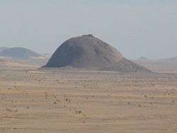
.jpg)
_p121_-_%C3%8Ele-de-France%2C_Vue_d'un_c%C3%AAt%C3%A9_des_Trois_Mamelles.jpg)
- African Great Lakes
- Mount Elgon on the Uganda-Kenya border
- Sweet Sixteen, Matthews Range (Ldoinyo Lenkiyio), Laikipia district, Rift Valley Province, northern Kenya.[10]
- Horn of Africa
- Indian Ocean
- Trois Mamelles mountains in the west of Mauritius
- Mamelles Island, Seychelles
- Southern Africa
- Omatako Mountain south-west of Otjiwarongo in Namibia
- Three Sisters in the Northern Cape, South Africa
- West Africa
Antarctica
- Una Peaks, long known as Una's Tits colloquially, at the entrance to the Lemaire Channel, Graham Land
- Nipple Peak, Palmer Archipelago, Graham Land
- Hemus Peak, Livingston Island, South Shetland Islands
Asia
- Cambodia
- Sroh-Plom Mountain, "Virtuous Woman's Breast Mountain", located close to Senmonorom, Senmonorom District, Mondulkiri Province, Cambodia.[11]
- China
- Rushan (meaning "Breast Mountain") is a mountain in Weihai, Shandong Province, China.
- Middle East
- Tell Sader al-Arus (translation from Arabic: "Breast of the bride") is a mountain in the Golan Heights, Israel.
- Philippines
- Bundok ng Susong Dalaga, "Maiden's Breast Mountain", Occidental Mindoro.[12]
- Mt. Tagapo, Talim Island, two huge conical hills that are the highest peaks of Talim Island.
- Chocolate Hills, more than a thousand unusual geological formations in Bohol. A popular tourist destination named for their brown colour in the summer.
- Ilihan Hill, "Watery Breast", a pilgrimage site about four kilometres from Jagna, Bohol
- Kagmasuso, among other breast-shaped hills in San Andrés, Catanduanes[13]
- Thailand
- Doi Phu Nom (ดอยภูนม), Phayao Province, a breast-shaped hill rising in an area of grassland of the Phi Pan Nam Range.[14]
- Khao Nom (เขานม), was one of the former names of Khanom, a district of Nakhon Si Thammarat Province, due to the surrounding mountains.[15]
- Khao Nom Nang, a hill at Huai Krachao, Kanchanaburi. 14°18′00″N 99°43′00″E / 14.30000°N 99.71667°E
- Khao Nom Nang, (เขานมนาง), a hill north of Pak Phraek, Kanchanaburi. 14°05′00″N 99°34′00″E / 14.08333°N 99.56667°E
- Khao Nom Nang, a hill between Nong Pet and Chong Sadao, Kanchanaburi. 14°21′02″N 99°12′53″E / 14.35056°N 99.21472°E
- Khao Nom Nang, an isolated hill in Khok Samae San, Lopburi. 15°19′00″N 100°51′00″E / 15.31667°N 100.85000°E
- Khao Nom Nang, an isolated large hill in Khao Kala, Nakhon Sawan Province. 15°34′00″N 100°17′00″E / 15.56667°N 100.28333°E
- Khao Nom Nang, the name of two hills west of Doeng Bang Nam Buat, Suphan Buri. 14°51′00″N 100°04′00″E / 14.85000°N 100.06667°E
- Khao Nom Sao (เขานมสาว), "female breast mountain", a mountain located in Ranong Province, Thailand.
- Khao Nom Sao, a round hill east of Phet Kasem road in Prachuap Khiri Khan Province. 10°59′00″N 99°22′00″E / 10.98333°N 99.36667°E
- Khao Nom Sao, a mountain in Chumphon Province. 09°46′00″N 98°43′01″E / 9.76667°N 98.71694°E
- Khao Nom Sao, a hill in Phang Nga Province, part of a greater mountain system. 08°58′00″N 98°28′00″E / 8.96667°N 98.46667°E
- Khao Nom Wang (เขานมวังก), a small hill just east of the main road at Phanom Wang, Khuan Khanun District, also known as Khao Phanom Wang, Phatthalung Province. 07°40′58″N 100°01′01″E / 7.68278°N 100.01694°E
- Ko Nom Sao (Thai: เกาะนมสาว, lit. female breast island) are twin islands located in the Phang Nga Bay,[16] Phang Nga Province, Thailand.
- Ko Nom Sao in Khao Sam Roi Yot National Park, Prachuap Khiri Khan Province.[17] 12°13′N 100°01′E / 12.217°N 100.017°E
- Ko Nom Sao, an island off the shore in Chanthaburi Province.[18][19] 12°28′N 102°01′E / 12.467°N 102.017°E
Europe
- UK and Ireland
- Mumbles The two islands (on one of which stands a lighthouse) off the southeast corner of the Gower peninsula, Swansea, Wales
- Beinn Chìochan in the Grampians, Scotland
- Bennachie in Aberdeenshire, Scotland
- Berwick Law In East Lothian,Scotland
- Mam Barisdale in Knoydart, Scotland
- Mynydd Llanwenarth near Abergavenny, Wales
- Mount Keen in Aberdeenshire / Angus, Scotland
- A' Chioch in Ben More, Isle of Mull, Scotland
- Mam Sodhail, on the northern side of Glen Affric, some 30 kilometres east of Kyle of Lochalsh
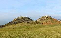
- Mam Tor, near Castleton in the High Peak of Derbyshire, England.[20]
- Samson, Isles of Scilly
- Twmbarlwm near Risca, Wales
- Wittenham Clumps in Oxfordshire
- Paps or Maiden Paps are rounded, breastlike hills located mostly in Scotland:
- Paps of Anu, near Killarney, Ireland
- Paps of Fife in Scotland
- Paps of Jura, on the western side of island of Jura, in the Inner Hebrides, Scotland
- Paps of Lothian in Scotland
- Maiden Paps, twin hills in Caithness, Scotland
- Maiden Paps, twin hills in the Kilpatrick Hills, Scotland
- Maiden Paps, twin hills south of Hawick in the Scottish Borders, Scotland
- Maiden Paps, another name for the Tunstall Hills near Sunderland, Tyne and Wear, England
- Maiden's Pap, another name for Schiehallion, Perth and Kinross, Scotland
- Pap of Glencoe in the Scottish Highlands
- Denmark
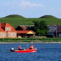
- Marens Patter (Maren's Tits), a pair of twin hills that has functioned as a landmark for seafarers since the Bronze Ages.
- Germany
- Lilienstein in Saxon Switzerland, Germany
- Greece
- Spain
- Tetica de Bacares or "La Tetica", a 2,086 m high mountain in the Sierra de Los Filabres, Spain.[21]
- Tetas de Liérganes, Cantabria
- Tetas de Viana, La Alcarria, Guadalajara Province
- Puig de Mamelles, Felanitx, Mallorca
- Ses Mamelles, another name for the 714 m high Puig des Castellot, Escorca, Mallorca
- Turó de la Mamella, a mountain near Vacarisses, Catalonia
- Burrén and Burrena[22] near Fréscano, Aragon
North and Central America
.JPG)
- Canada
- Squaw's Tit in the Canadian Rockies of Alberta
- El Salvador
- San Vicente, also known as Chichontepec, the mountain of the two breasts in Nahuat, a stratovolcano in El Salvador
- Guadeloupe
- Mamelles, Guadeloupe
- Haiti
- Morne Deux Mamelles, Haiti
- Mexico
- Tres Tetas Mountain or El Chichión in Costa Grande of Guerrero, Mexico
- Puerto Rico
- Cerro Las Tetas in Salinas, Puerto Rico, Puerto Rico
- Tetas de Cerro Gordo in San Germán, Puerto Rico
- United States
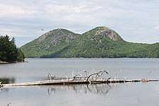
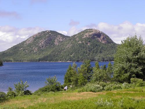
- Bubble Mountains, in Acadia National Park of Maine.[23]
- Nippletop, in the Adirondack High Peaks of New York. During the later 19th century, it was euphemistically renamed "Dial Mountain", a name now officially applied to another nearby peak.
- Pilot Mountain, Pilot Mountain, North Carolina. Referenced many times on the Andy Griffith Show as Mt. Pilot. Andy spoke about a wonderful place to travel called "Pilot" by the locals.
- Pinnacle Mountain, Arkansas, near Maumelle. During the colonial and early American periods, the mountain was known as "Mamelle" mountain. "Mamelle" is a name commonly applied in the French-speaking parts of the world to a breast.[24]
- Rock Mary, Caddo County, Oklahoma
- Spanish Peaks, Colorado, named Huajatolla by the Ute Indians, meaning "two breasts".[25]
- Tetilla Peak, Caja del Rio, New Mexico. "Tetilla" is Spanish for "nipple".
- Teton Range. French-Canadian trappers named the Grand Teton Mountains around 1820. The distinctive peaks appeared as Les Trois Tetons (The Three Breasts) seen from the north[26]
- Twin Peaks, in San Francisco, California. When the Spanish conquistadors and settlers arrived at the beginning of the 18th century, they called the area "Los Pechos de la Chola" or "Breasts of the Indian Maiden" and devoted the area to ranching.[27] When San Francisco passed under American control during the 19th Century, it was renamed "Twin Peaks".
- Maggie's Peaks, just west of Lake Tahoe, California.
- Uncanoonuc Mountains, Goffstown, New Hampshire. From a Native American word for a woman's breasts.[28]
- Mollie's Nipple or Molly's Nipple is the name given to as many as seven peaks and some other geological features in Utah.
- Squawteat Peak located in Pecos County, Texas west of Bakersfield.[29]
- Betsy Bell and Mary Gray, two adjacent hills in Staunton, Virginia.
Oceania
- Australia
- Pigeon House Mountain, NSW, Australia
- Mammaloid Hills, Victoria, Australia
- New Zealand
South America
- Argentina
- Bolivia
- Chile
- Cerro de Las Tetas, Chile
- Tetas del Biobío, formed by Cerro Teta Norte and Cerro Teta Sur, located in the mouth of the Biobío River, Chile.

- Colombia
- Cerro La Teta, La Guajira, Colombia
- Cerro de Las Tetas, Serranía del Perijá, La Guajira, Colombia
- Cuba
- French Guiana
- Les Mamelles Islets, French Guiana
- Peru
- Cerro Tetas, Chiclayo Province, Peru
- Uruguay
- Cerro Batoví, in Tacuarembó. Batoví means breast of a virgin in the Guaraní language.[31]
- Cerro Pan de Azúcar (Sugarloaf Hill), in the Maldonado Department
- Venezuela
- Tetas de María Guevara, Isla Margarita, Venezuela
- Teta de Niquitao, Trujillo State, Venezuela[32]
- Cerro de Las Tetas, Tinaquillo, Cojedes, Venezuela
- Cerro las Tres Tetas, Barquisimeto, Venezuela
In fiction
- Sheba's Breasts are a pair of mountains in Africa in the novel King Solomon's Mines
- The Teats and the Paps are pairs of hills in George R.R. Martin's A Song of Ice and Fire
Gallery
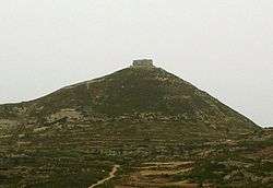
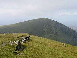
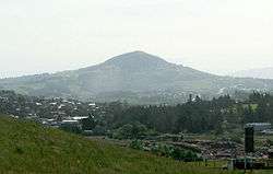
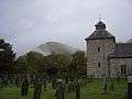 Church tower at Pennant Melangell with the breast-shaped hill in the background
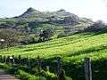 Las Tetas de Lierganes, Cantabria, Spain
_as_seen_from_PR-52_NB_Rest_area_at_km_49.0.jpg) Cerro Las Tetas, Salinas, Puerto Rico, as seen from the PR-52 northbound rest area at km 49.0
Cerro Las Tetas, Salinas, Puerto Rico, as seen from the PR-52 northbound rest area at km 49.0
See also
References
- ↑ "The feminine in early Irish myth and legend". Scoilnet. Archived from the original on 11 June 2011. Retrieved 4 April 2011.
- ↑ Mills, A.D. (2003). A Dictionary of British Place-Names. Oxford: Oxford University Press. ISBN 0-19-852758-6.
- ↑ Hylton (2003), p. 6.
- ↑ Samson, South Hill Chambered Cairn - The Megalithic Portal
- ↑ Samson, North Hill - The Megalithic Portal
- ↑ Burrén. Parque Arqueológico de la Primera Edad del Hierro en Frescano
- ↑ "The Story of Bodhidharma". USA Shaolin Temple. Retrieved 4 April 2011.
- ↑ Moureau, M.; Brace, G. (January 2008). Dictionnaire Du Petrole Et Autres Sources D'Energie: Anglais-Franncais, Francais-Anglais [Comprehensive Dictionary of Petroleum and Other Energy Sources]. Editions Technip. p. 936. ISBN 2-7108-0911-7. Retrieved 4 April 2011.
- ↑ Decobecq, Dominique. "L'histoire du cratère Dolomieu (Piton de la Fournaise)" (in French). Retrieved 4 April 2011.
- ↑ Jackman, Brian (16 January 2009). "Africa: taking flight over Kenya's elephant country". The Daily Telegraph. Retrieved 4 April 2011.
- ↑ Lay, Vicheka (2007). "Cambodian Resort "Virtuous Woman's Breast" Mountain". Free Online Library. Retrieved 4 April 2011.
- ↑ "Maiden's breast mountain, Occ. Mindoro (photo)". Retrieved 4 April 2011.
- ↑ "Virac (Capital Town)". Catanduanes Local Government. 2010. Retrieved 4 April 2011.
- ↑ Doi Phu Nom picture
- ↑ "The Legend of Khanom". Ice Family Tour. 2007. Archived from the original on 2 April 2011. Retrieved 4 April 2011.
- ↑ "Nom Sao Island (Ko Nom Sao)". Thailand.com. Archived from the original on 22 March 2006. Retrieved 4 April 2011.
- ↑ Khao Sam Roi Yot National Park - Activities Archived March 17, 2010, at the Wayback Machine.
- ↑ Ko Nom Sao
- ↑ Chanthaburi, Laem Sing Beach
- ↑ "The meaning of place names in Ashfield". Ashfield District Council. Retrieved 4 April 2011.
- ↑ "Tetica de Bacares, Sierra de los Filabres (2.080 m. altitud) (photo)". Panoramio. Retrieved 4 April 2011.
- ↑ Burrén y Burrena, las "dos teticas" con historia en Fréscano Archived 2011-04-30 at the Wayback Machine.
- ↑ "Bubble Mountains". Hike Bubble Mountains ME. July 2010. Retrieved 2 September 2011.
- ↑ "Pinnacle Mountain State Park". The Encyclopedia of Arkansas History & Culture. 4 February 2011. Retrieved 4 April 2011.
- ↑ Evans, Frances P. (August 1958). "The Mystic Huajatolla". Trail and Timberline. Colorado Mountain Club: 103.
- ↑ "Geology". Jackson Hole.com. 2011. Archived from the original on 8 February 2011. Retrieved 4 April 2011.
- ↑ http://www.sfgov.org/site/uploadedfiles/recpark/volunteer/Community_Catalyst_Newsletters/brochure_web%281%29.pdf sfgov.org Archived June 14, 2011, at the Wayback Machine.
- ↑ "Uncanoonuc Mountains". Dan LaRochelle. Retrieved 9 April 2012.
- ↑ Squawteat Peak archaeological site, The Handbook of Texas
- ↑ Cerro Tres Tetas - Argentina
- ↑ "Cerro Batoví" (in Spanish). Enciclopedia Geográfica del Uruguay. Retrieved 4 April 2011.
- ↑ "Teta de Niquitao" (in Spanish). Cúspides Venezuela. 2008. Retrieved 4 April 2011.