Knoydart
Knoydart
| |
|---|---|
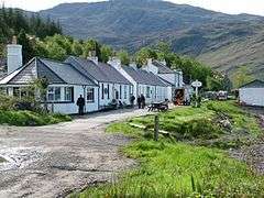 Inverie on the Knoydart peninsula | |
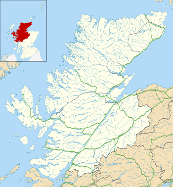 Knoydart Knoydart shown within the Highland council area | |
| Population | 157 [1] |
| Community council | |
| Council area | |
| Lieutenancy area | |
| Country | Scotland |
| Sovereign state | United Kingdom |
| Post town | MALLAIG |
| Postcode district | PH41 |
| Dialling code | 01687 |
| EU Parliament | Scotland |
| UK Parliament | |
| Scottish Parliament | |
| Knoydart National Scenic Area | |
|---|---|
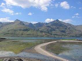 Ladhar Beinn from Eileann Choinneach | |
| Location | Argyll and Bute, Scotland |
| Area | 507 km2 (196 sq mi)[2] |
| Established | 1981 |
| Governing body | Scottish Natural Heritage |
Knoydart /ˈnɔɪdərt, ![]()
Knoydart is designated as one of the forty national scenic areas in Scotland, which are defined so as to identify areas of exceptional scenery and to ensure its protection from inappropriate development.[5] The designated area covers 50,696 ha in total, of which 40,201 ha is on land, with a further 10,495 ha being marine (i.e. below low tide level).[2]
The area is popular with hill walkers, mountaineers, sailors and wildlife enthusiasts. It includes the Munros of Ladhar Bheinn (1020 m), Luinne Bheinn (939 m), Meall Buidhe (946 m) and Sgurr na Cìche (1040 m).[6] The peninsula also contains six Corbetts, including Ben Aden (887 m) and Beinn na Caillich (785 m).[7]
History

Knoydart formed part of the kingdom of Somerled (died 1164), before passing to the Clann Ruaidhrí branch of his descendants – the eventual heiress of whom married John of Islay (died circa 1386). Members of Clan Donald held Knoydart from the 15th century to the beginning of the 17th century is generally believed to have descended from Allan Macdonald, 2nd of Clanranald (died circa 1429). However, in the early 17th century, Macdonell of Glengarry succeeded in wresting control of Knoydart from Clanranald, receiving official confirmation of his ownership from the king in 1613.[8] Prior to the 1745 Jacobite rising the population numbered nearly a thousand. There was much emigration, mainly to Canada (Knoydart, Nova Scotia is named after the community). Despite this emigration, the population remained at nearly a thousand in 1841.
In 1852 four hundred of the inhabitants were given notice of eviction for the following year and offered passages overseas, originally to Australia, but later their destination was changed to Canada. On 9 August 1853 three hundred and thirty inhabitants from the west coast of the peninsula went on board the Sillery and left for Canada. However, 11 families comprising over 60 people refused to go and the story of their eviction became notorious as part of the Highland Clearances. Knoydart was finally sold by the MacDonell family in 1856, passing into the hands of an Ayrshire ironmaster, James Baird of Cambusdoon.
In 1948 an unsuccessful land raid was undertaken by the "Seven Men of Knoydart" who attempted to claim land in the ownership of the estate for their own use. Their claims were contested by the estate owner, the Second Baron Brocket who took the case to the Court of Session which ruled against the land-raiders. An appeal to the Secretary of State for Scotland was rejected and the Seven Men gave up their fight to obtain crofts on Knoydart. A cairn commemorating the Land Raid was unveiled at Inverie in 1981.[9]
Modern ownership
The Knoydart Foundation was established in 1997 to take ownership of the 17,500-acre (71 km2) Knoydart Estate which makes up much of the peninsula,[10] It is a registered charity under Scottish law.[11], including the village of Inverie.[12] The Foundation bought the estate in 1999.[13] It is a partnership of local residents, the Highland Council, the Chris Brasher Trust, and the John Muir Trust. The foundation aim is to "manage the Knoydart Estate as an area of employment and settlement on the Knoydart Peninsula without detriment to its natural beauty and character and to seek and encourage the preservation of its landscape, wildlife, natural resources, culture and rural heritage."[14]
The neighbouring privately-owned Kilchoan Estate was part of the foundation when it was set up, but have since resigned their directorship.[14] Kilchoan Estate covers 13,212 acres (53.47 km2) of the peninsular, and lies to the east of the Knoydart Foundation land.[15] Other landholdings on Knoydart include the 8,080-acre (32.7 km2) Camusrory Estate (lying to the east of the Kilchoan Estate),[16] and the 14,230-acre (57.6 km2) Barisdale Estate on the northern side of the peninsular and extending as far east as Kinloch Hourn.[17] 3,063 acres (12.40 km2) of land on the northern slopes of Ladhar Bheinn is owned by the John Muir Trust, one of the participants in the Knoydart Foundation.[18][19]
Infrastructure
Inverie is the main settlement on the peninsula, which has a resident population of 98 adults. There is a post office, a primary school, and a variety of accommodation for visitors, including B&Bs, bunkhouses and self-catering accommodation. The Old Forge Inn, Knoydart's only pub, is the most remote public house in mainland Britain.[20][21]
A vehicle track runs from Inverie to the smaller settlement of Airor, on the west side of the peninsula, a little over 8 miles. On its way to Airor, the track passes the settlements of Scottas, Sandaig and Doune. The track is a designated public highway and is maintained by the Highland Council – however in common with the Small Isles, a resident or visitors permit is required to drive on the road.[22]
The Highland Council-subsidised ferry is operated from Mallaig to Inverie by Western Isles Cruises,[23] previously known as Bruce Watt Cruises.[24] For a period of three years Knoydart Sea Bridge[25] had the council contract; this reverted to Western Isles Cruises on 1 April 2016. Various passenger and equipment services are offered by private boat operators.[26] The Foundation operates a micro hydro-electric scheme which provides power to the estate as the area is entirely off the national grid. An increase in demand for power during the summer, when the area has visitors, has led to localised power cuts. A Wi-Fi light bulb able to change colour and a website (introduced in 2015) drawing on information from the hydroelectric turbine warns residents when they are close to the maximum available power. The project was developed by a team from the University of Edinburgh.[27]
In May 2005 the Highlands and Islands Community Energy Company hosted its first conference in Inverie, during which the company was officially launched.[28] A new pier at Inverie was officially opened on 24 August 2006 by Tavish Scott MSP.[29] In 2009 the Knoydart Foundation celebrated 10 years of community ownership with an extensive timetable of events including a music festival, ceilidhs, volunteer weeks, talks, an art display and a book reading by the author Ian McEwan.[29]
Natural environment
The underlying geology of Knoydart consists mainly of mica-schist and quartz-feldspar of the type associated with the Moine thrust, along with some areas of Lewisian gneiss around Loch Hourn. The landscape shows many signs of glaciation, with deep fjord-like sea lochs, hanging valleys, corries, arêtes and moraines. The rebound effect that followed the melting of the glaciers at the end of the ice age has led to the formation of raised beaches.[3]
Birchwoods grow on the steep slopes of the glens and above the shoreline, and there are some areas of Caledonian pinewoods around Barrisdale.[3] In common with much of the highlands, historic overgrazing, first by sheep and latterly by deer (predominantly red deer), has led to a reduction in the amount of forested land. The deer population is therefore managed by culling in order to allow existing native woodland to regenerate over the long term. The estates on the western part of the peninsula cooperate in this aim via the West Knoydart Deer Management Group,[30] whilst the more easterly estates form the Knoydart Deer Management Group, whose area takes in much of The Rough Bounds of Knoydart.[31] There was controversy in 2015 following culling on the John Muir Trust land in the north of Knoydart, which resulted in some deer carcasses being left on the open hillside rather than being extracted for use as venison.[32][33]
Wildlife in the area includes badgers, pine marten, otters, red deer, buzzards, golden eagles and sea eagles;[34] there are also two small herds of feral goats.[30] There is a wildlife hide on the beach near Inverie.[34] The seas to the west of Knoydart are designated as a Special Area of Conservation due their importance for harbour porpoises.[35]
Gallery
 The interior of Knoydart
 Knoydart from Loch Hourn
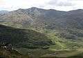 Southern Knoydart
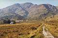 A rare plain
References
- ↑ "2011 Census Profile for Output Area S00117868". National Records of Scotland. Retrieved 2018-04-04.
- 1 2 "National Scenic Areas - Maps". SNH. 2010-12-20. Retrieved 2018-03-04.
- 1 2 3 4 "The special qualities of the National Scenic Areas" (PDF). Scottish Natural Heritage. 2010. pp. 190–197. Retrieved 2018-04-04.
- ↑ "Knoydart: Britain's last wilderness". The Independent. 2009-03-21. Retrieved 2018-04-04.
- ↑ "National Scenic Areas". Scottish Natural Heritage. Retrieved 2018-01-17.
- ↑ D. Bennet & R. Anderson. The Munros: Scottish Mountaineering Club Hillwalkers Guide, pp.164-171. Published 2016.
- ↑ R. Milne & H. Brown. The Corbetts and Other Scottish Hills: Scottish Mountaineering Club Hillwalkers Guide, pp.169-174. Published 2002.
- ↑ Dennis Rixson, Knoydart: A History (Birlinn Ltd, Edinburgh, 1999)
- ↑ MacDougall, A. (1993). Knoydart: The Last Scottish Land Raid. Billingham, Cleveland: Lindhurst Publications.
- ↑ "Knoydart Foundation". Retrieved 2007-04-22.
- ↑ "Knoydart Foundation, Registered Charity no. SC026246". Office of the Scottish Charity Regulator.
- ↑ "Property Page: Knoydart Estate". Who Owns Scotland. 2010-09-21. Retrieved 2018-04-04.
- ↑ "Residents' buy-out victory". BBC News. 2 March 1999. Retrieved 22 April 2007.
- 1 2 "Knoydart Foundation: About the Foundation". Knoydart Foundation. Retrieved 2018-04-04.
- ↑ "Property Page: Kilchoan Estate". Who Owns Scotland. 2003-12-31. Retrieved 2018-04-04.
- ↑ "Property Page: Camusrory Estate". Who Owns Scotland. 2003-12-31. Retrieved 2018-04-04.
- ↑ "Property Page: Barisdale Estate". Who Owns Scotland. 2010-09-21. Retrieved 2018-04-04.
- ↑ "Property Page: Li and Coire Dhorrcail". Who Owns Scotland. 2010-09-21. Retrieved 2018-04-04.
- ↑ "Knoydart - Trust Land". John Muir Trust. Retrieved 2018-04-04.
- ↑ "Old Forge". Retrieved 22 April 2007.
- ↑ Hutchison, Colin (12 November 2006). "Remote patrol". Sunday Herald. Glasgow.
- ↑ Knoydart Permits. "Knoydart Permits". Highland Council. Retrieved 18 August 2014.
- ↑ "Knoydart Ferry Service". Retrieved 12 May 2016.
- ↑ "Knoydart Ferry Service". Retrieved 22 April 2007.
- ↑ "Knoydart Ferry Service". Retrieved 4 July 2013.
- ↑ Getting Here. "Getting Here". Knoydart Foundation. Archived from the original on 6 November 2011. Retrieved 12 November 2011.
- ↑ David Ross "Village's power-cut problem solved by lightbulb", The Herald (Glasgow), 26 May 2015
- ↑ HIE News (2006-04-18). "Community Energy: Leading from the Edge". Retrieved 22 April 2007.
- 1 2 "Knoydart Foundation". Retrieved 14 May 2009.
- 1 2 "Deer Management Plan" (PDF). West Knoydart Deer Management Group. 2017-11-20. Retrieved 2018-04-05.
- ↑ "Knoydart Deer Management Group". Knoydart Deer Management Group. Retrieved 2018-04-05.
- ↑ "Deer management in Knoydart – a response from the John Muir Trust". John Muir Trust. 2016-01-07. Retrieved 2018-04-05.
- ↑ "The Knoydart deer massacre – what can we learn from it?". Association of Deer Management Groups. 2015-12-24. Retrieved 2018-04-05.
- 1 2 "Ranger Service". Knoydart Foundation. Retrieved 2018-04-04.
- ↑ "Site Details for Inner Hebrides and the Minches". Scottish Natural Heritage. 2018-03-05. Retrieved 2018-04-05.