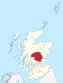
Perth and Kinross
| Perth and Kinross Pairth an Kinross Peairt agus Ceann Rois | ||
|---|---|---|
 | ||
| ||
| Admin HQ | Perth | |
| Government | ||
| • Body | Perth & Kinross Council | |
| • Control | Con + LD + Ind (council NOC) | |
| • MPs | ||
| • MSPs | ||
| Area | ||
| • Total | 2,041 sq mi (5,286 km2) | |
| Area rank | Ranked 5th | |
| Population (mid-2017 est.) | ||
| • Total | 151,100 | |
| • Rank | Ranked 12th | |
| • Density | 70/sq mi (28/km2) | |
| ONS code | S12000024 | |
| ISO 3166 code | GB-PKN | |
| Website | http://www.pkc.gov.uk/ | |


Perth and Kinross (Scots: Pairth an Kinross; Scottish Gaelic: Peairt agus Ceann Rois) is one of the 32 council areas of Scotland and a Lieutenancy Area. It borders onto the Aberdeenshire, Angus, Argyll and Bute, Clackmannanshire, Dundee, Fife, Highland and Stirling council areas. Perth is the administrative centre. With the exception of a large area of south-western Perthshire, the council area mostly corresponds to the historic counties of Perthshire and Kinross-shire.
Perthshire and Kinross-shire shared a joint county council from 1929 until 1975. The area formed a single local government district in 1975 within the Tayside region under the Local Government (Scotland) Act 1973, and was then reconstituted as a unitary authority (with a minor boundary adjustment) in 1996 by the Local Government etc. (Scotland) Act 1994.
City
Towns and villages
- Abbots Deuglie
- Abernethy
- Aberfeldy
- Acharn
- Airntully
- Almondbank
- Alyth
- Amulree
- Auchlyne
- Auchterarder
- Balado
- Balbeggie
- Ballinluig
- Bankfoot
- Birnam
- Blackford
- Blair Atholl
- Blairgowrie
- Blairingone
- Braco
- Bridge of Balgie
- Bridge of Cally
- Bridge of Earn
- Bridge of Tilt
- Burrelton
- Campmuir
- Clunie
- Comrie
- Coupar Angus
- Crieff
- Dull
- Dunkeld
- Dunning
- Errol
- Fearnan
- Finegand
- Forgandenny
- Forteviot
- Fortingall
- Glencarse
- Glenfarg
- Glenshee
- Grandtully
- Inchture
- Invergowrie
- Kenmore
- Killiecrankie
- Kingoodie
- Kinloch Rannoch
- Kinross
- Kinrossie
- Kirkmichael
- Lawers
- Leetown
- Logierait
- Longforgan
- Luncarty
- Madderty
- Meigle
- Meikleour
- Methven
- Milnathort
- Moneydie
- Muthill
- Pitcairngreen
- Pitlochry
- Rattray
- Redgorton
- Scone
- Scotlandwell
- Spittal of Glenshee
- Stanley
- St Fillans
- St Madoes
- Trinafour
- Waterloo
- Weem
Places of interest
- Arndean House
- Ashintully Castle
- Atholl Country Life Museum
- Ben Lawers
- Blackhall Roman Camps
- Blair Atholl Mill
- Blair Castle
- Cateran Trail
- Cairngorms National Park
- Castle Menzies
- Clan Donnachaidh Centre
- Cluny House Gardens
- Dirnanean House
- Drummond Castle
- Edradour Distillery
- Forest of Atholl
- Fortingall Yew
- Glen Lyon
- Grampian Mountains
- Kindrogan House
- Loch Earn
- Loch Lomond and the Trossachs National Park
- Loch Rannoch
- Loch Tay
- Melville Monument
- Portmoak
- Rannoch Moor
- Strathearn
- Whitefield Castle
Council political composition
| Party | Councillors | |
| Conservative | 17 | |
| Scottish National Party | 15 | |
| Liberal Democrat | 4 | |
| Independent | 3 | |
| Labour | 1 | |
On 18 September 2014, Perth and Kinross, voted "No" in the Scottish Independence Referendum at 60.2% with an 86.9% turnout rate.[1]
References
External links
| Wikivoyage has a travel guide for Perth and Kinross. |
- Perth and Kinross Council
- "Scottish Local Government areas and history". Archived from the original on 2013-03-02.
- The Perthshire Diary - 365 history stories
- Perth City
- A Vision of Britain Through Time: A vision of Perth and Kinross
- Perth and Kinross at Curlie (based on DMOZ)