Bloomfield, Vermont
| Bloomfield, Vermont | |
|---|---|
| Town | |
 | |
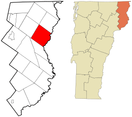 Location in Essex County and the state of Vermont. | |
 Location of Vermont with the U.S.A. | |
| Coordinates: 44°47′44″N 71°38′6″W / 44.79556°N 71.63500°WCoordinates: 44°47′44″N 71°38′6″W / 44.79556°N 71.63500°W | |
| Country | United States |
| State | Vermont |
| County | Essex |
| Area | |
| • Total | 40.5 sq mi (105.0 km2) |
| • Land | 40.3 sq mi (104.4 km2) |
| • Water | 0.2 sq mi (0.6 km2) |
| Elevation | 1,804 ft (550 m) |
| Population (2010) | |
| • Total | 221 |
| • Density | 5/sq mi (2.1/km2) |
| • Households | 101 |
| • Families | 75 |
| Time zone | UTC-5 (EST) |
| • Summer (DST) | UTC-4 (EDT) |
| ZIP code | 05905 |
| Area code(s) | 802 |
| FIPS code | 50-009-06325[1] |
| GNIS feature ID | 1462044[2] |
Bloomfield is a town in Essex County, Vermont, United States. The population was 221 at the 2010 census,[3] down from 261 at the 2000 census. It is part of the Berlin, NH–VT Micropolitan Statistical Area. On December 30, 1933, Bloomfield set a record low temperature for New England with −50 °F (−46 °C), a record tied along the Big Black River, Maine, on January 16, 2009.
History
In 1830, an act from the state General Assembly changed the name of the town from "Minehead" to "Bloomfield."[4]
Geography
Bloomfield is in northeastern Essex County, along the Connecticut River, which forms the state line with New Hampshire. The town is bordered to the southwest by Brunswick, to the northwest by Lewis, at its northernmost point by Averill, and to the northeast by Lemington, Vermont, while to the southeast, across the river, it is bordered by the towns of Columbia and Stratford, New Hampshire. The settlement of Bloomfield is in the southern corner of the town, at the mouth of the Nulhegan River in the Connecticut, and connected by bridge to the village of North Stratford, New Hampshire.
Vermont Route 102 follows the Connecticut River along the southeastern edge of the town, leading northeast 13 miles (21 km) to Colebrook, New Hampshire, and south 15 miles (24 km) to Guildhall, Vermont, while Vermont Route 105 leads west up the Nulhegan River 16 miles (26 km) to Island Pond.
According to the United States Census Bureau, the town has a total area of 40.5 square miles (105.0 km2), of which 40.3 square miles (104.4 km2) is land and 0.2 square miles (0.6 km2), or 0.59%, is water.[3] The highest point in the town is 2,470 feet (750 m) along the northeast boundary.
Demographics
| Historical population | |||
|---|---|---|---|
| Census | Pop. | %± | |
| 1800 | 27 | — | |
| 1810 | 144 | 433.3% | |
| 1820 | 132 | −8.3% | |
| 1830 | 150 | 13.6% | |
| 1840 | 179 | 19.3% | |
| 1850 | 244 | 36.3% | |
| 1860 | 320 | 31.1% | |
| 1870 | 455 | 42.2% | |
| 1880 | 627 | 37.8% | |
| 1890 | 827 | 31.9% | |
| 1900 | 504 | −39.1% | |
| 1910 | 496 | −1.6% | |
| 1920 | 382 | −23.0% | |
| 1930 | 417 | 9.2% | |
| 1940 | 326 | −21.8% | |
| 1950 | 291 | −10.7% | |
| 1960 | 212 | −27.1% | |
| 1970 | 196 | −7.5% | |
| 1980 | 188 | −4.1% | |
| 1990 | 253 | 34.6% | |
| 2000 | 261 | 3.2% | |
| 2010 | 221 | −15.3% | |
| Est. 2014 | 215 | [5] | −2.7% |
| U.S. Decennial Census[6] | |||
As of the census[1] of 2000, there were 261 people, 101 households, and 75 families residing in the town. The population density was 6.5 people per square mile (2.5/km2). There were 191 housing units at an average density of 4.7 per square mile (1.8/km2). The racial makeup of the town was 95.40% White, 1.53% Native American, 0.38% Asian, and 2.68% from two or more races.
There were 101 households out of which 34.7% had children under the age of 18 living with them, 61.4% were married couples living together, 6.9% had a female householder with no husband present, and 25.7% were non-families. 23.8% of all households were made up of individuals and 13.9% had someone living alone who was 65 years of age or older. The average household size was 2.58 and the average family size was 3.03.
In the town, the population was spread out with 27.2% under the age of 18, 4.2% from 18 to 24, 29.9% from 25 to 44, 23.8% from 45 to 64, and 14.9% who were 65 years of age or older. The median age was 39 years. For every 100 females, there were 119.3 males. For every 100 females age 18 and over, there were 108.8 males.
The median income for a household in the town was $33,500, and the median income for a family was $39,167. Males had a median income of $27,708 versus $20,357 for females. The per capita income for the town was $17,224. About 3.2% of families and 4.0% of the population were below the poverty line, including none of those under the age of eighteen and 7.7% of those sixty-five or over.
References
- 1 2 "American FactFinder". United States Census Bureau. Archived from the original on 2013-09-11. Retrieved 2008-01-31.
- ↑ "US Board on Geographic Names". United States Geological Survey. 2007-10-25. Retrieved 2008-01-31.
- 1 2 "Geographic Identifiers: 2010 Census Summary File 1 (G001): Bloomfield town, Essex County, Vermont". American Factfinder. U.S. Census Bureau. Retrieved March 31, 2016.
- ↑ "Laws of Vermont, of a Public and Permanent Nature, coming down to, and including the year 1834". p. 177.
- ↑ "Annual Estimates of the Resident Population for Incorporated Places: April 1, 2010 to July 1, 2014". Retrieved June 4, 2015.
- ↑ "U.S. Decennial Census". United States Census Bureau. Archived from the original on May 12, 2015. Retrieved May 16, 2015.
Places adjacent to Bloomfield, Vermont | |
|---|---|
Municipalities and communities of Essex County, Vermont, United States | ||
|---|---|---|
| Towns |  | |
| CDPs | ||
| Grants and gores | ||
| Other communities | ||
| Footnotes | ‡ Unorganized | |