Bihar Sharif
| Bihar Sharif बिहार शरीफ | |
|---|---|
| Sub-Metropolitan | |
 Bihar Sharif Location in Bihar, India | |
| Coordinates: 25°11′49″N 85°31′05″E / 25.197°N 85.518°ECoordinates: 25°11′49″N 85°31′05″E / 25.197°N 85.518°E | |
| Country | India |
| State | Bihar |
| Division | Patna |
| District | Nalanda district |
| Government | |
| • Body | Bihar sharif Municipal Corporation |
| Elevation | 55 m (180 ft) |
| Population (2016) | |
| • Total | 369,972 |
| • Rank |
5th in Bihar 153rd in India |
| Languages | |
| • Spoken | Magahi, Hindi, Urdu |
| Time zone | UTC+5:30 (IST) |
| PIN | 803101 803118 |
| Telephone code | 06112 |
| ISO 3166 code | IN-BR |
| Vehicle registration | BR-21 |
| Loksabha Constituency | Nalanda |
| Vidhan Sabha Constituency | Bihar Sharif (172) |
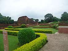
Bihar Sharif is the headquarters of Nalanda district and the fifth-largest sub-metropolitan area in the eastern Indian state of Bihar. Its name is a combination of two words: Bihar, derived from vihara (meaning Buddhist monastery), also the name of the state; and Sharif, referring to the resting place of the Sufi saint Makhdoom Sharfuddin Ahmed Yahya Maneri. The city is a hub of education and trade in south Bihar, and the economy centers around agriculture supplemented by tourism, the education sector and household manufacturing. The ruins of the ancient Nalanda Mahavihara, a UNESCO World Heritage Site, are located near the city.

Under the Pala Empire, Odantapuri, a major Buddhist monastic university was built at the site of Bihar Sharif. It eventually became the capital of Magadha, and then part of the Muslim Delhi Sultanate in the late 12th century, though local Rajputs soon re-established effective control. In the early 14th century, it was permanently captured by the Delhi Sultanate. Bihar Sharif was later ruled by other Muslim dynasties and then the British until Indian independence in 1947. The city has important Jain, Buddhist, Hindu and Muslim heritage and landmarks.
Bihar Sharif is one of the hundred Indian cities competing to gain funds under Prime Minister Narendra Modi's flagship Smart Cities Mission.[1] Bihar Sharif was selected in the preliminary list of 100 cities in July 2015 that were to compete for the Smart Cities project. As far as funding is concerned, the municipal corporation would continue to receive annual funding until the completion of the Smart Cities project, which was initially supposed to come to an end in the fiscal year 2019-20 but is now likely to be extended up to the fiscal year 2021-22.
History
Pre-Islamic period and Odantapuri University
The name Bihar is derived from vihar or vihara, meaning Buddhist monastery, a reference to the ancient Odantapuri University established near the city in the 7th century CE by Pala king Gopala I.[2][3] The settlement does, however, predate the Buddha. It became the capital of the Magadha kingdom from the rule of the Pala Empire. Odantapuri is considered to have been the second oldest of India's Mahaviharas, and it was located at the foot of Bari Pahari (English: Big Hill). According to Tibetan records it housed about 12,000 students and was an important centre of Buddhist learning. Acharya Sri Ganga of Vikramashila was a student there.
Delhi Sultanate era
In 1193, during the time of Ikhtiyar ad-Din Muhammad bin Bakhtiyar Khilji's conquest of Bihar, he came to conquer eastern parts of India and destroyed Nalanda University. En route to Nalanda, he allegedly damaged the Buddhist monasteries of a place now called Bakhtiyarpur. He then came to Vihar, where he completely destroyed Odantapuri University, and the Buddhist viharas before leaving for Nalanda. A few years after Khilji's departure, local Bundela Rajputs regained control of the city from its Muslim rulers. Bundela Rajputs then ruled the area until the reign of Raja Biththal, remaining autonomous for all practical purposes despite nominal control from Delhi.
Delhi Sultan Muhammad bin Tughluq (r. 1324–1351 CE) then sent Syed Ibrahim Mallick with an army to conquer the Magadha region. After a fierce battle, the outnumbered Raja army was defeated and Raja Biththal was killed. The conquest of Bihar was a major achievement for Delhi, and on this occasion the Sultan conferred upon Syed Ibrahim Mallick the title of "Madarul Mulk", after which he was called "Mallick Baya". He was then appointed governor of Bihar by the Sultan, and he ruled over the region until his assassination in 1353 CE. Descendants of the Bundela Rajputs are now settled in Tungi village and Garhpar in Bihar Sharif.
Later history
After the Delhi Sultanate, the first Sur emperor, Sher Shah Suri (r. 1540–1545 CE), moved the regional capital to Patliputra (modern-day Patna), and the whole Magadha region came to be called Bihar.
In 1867, the city was officially declared a municipality.[2]
Geography
Bihar Sharif is located 74 km (46 mi) from Patna, the capital of Bihar state (via NH 30 and 20). It is situated at the foot of Badi Pahari (a.k.a. Hiranya Parbat) and on the bank of the Panchanan River. The land around Bihar Sharif is very fertile, with alluvial soil deposited by several rivers. These local rivers include the Mahane, the Panchanan – which divides west of Pawapuri into the Goithwa, Soyaba and smaller rivers – the Zerain, and others. To the west is the Paimar River, a tributary of the Ganges.[2]
Economy
Agriculture is the main economic activity of Bihar Sharif, with crops including cauliflower, potato, mustard seed and other vegetables, which are sold to neighbouring states.

Tourism to nearby sites like Nalanda, Rajgir and Pawapuri also boosts the city's economy considerably, as do footwear and garments manufactured by household industries.
As of 1981, the city had a major beedi cigarette industry which employed 15,000 people, mainly Muslims and some lower-caste Hindus.[4]
In recent years the city has changed from a trade-based economy to an education hub. Various schools and coaching centres are a new symbol of awareness about education among people in the surrounding rural areas.
Bihar Sharif is one of four cities selected in Bihar state among the 100 Indian cities to developed as smart cities under Prime Minister Narendra Modi's flagship Smart Cities Mission.[5] It was not included in the first twenty cities to receive funding.[6]
Demographics
As of the 2011 India census, Bihar Sharif had a population of 297,268,[7] up from 231,972 in 2001[8] and around 130,000 in 1981.[4] The sex ratio was 916 females per 1000 males, with a slightly higher ratio of 927 females per 1,000 males among children.[7] The overall literacy rate was 75.30%, with male literacy at 80.80% and female literacy at 69.28%.[7] Caste groups with significant populations include the Kurmi, Koyri, Yadav, and Baniyas. Most Muslims speak Urdu and belong to the Sunni Hanafi denomination. The Koyri and Baniya are old settlers while others have moved from villages around the city.
Religion
According to the 2011 census, 65.86% of the city's population identifies as Hindu, 33.59% identifies as Muslim, 0.34% did not answer the census question, 0.17% identifies as Christian, and fewer than fifty identified with each of the other religious groups on the survey.[7] A 1981 report lists a 48% proportion of Muslims and notes this as unusual for the area.[4]
In 2012, plans were announced for the construction of a local Bahá'í House of Worship in Bihar Sharif.[10] This would be only the second House of Worship for India's nearly two million Bahá'ís[11] (the first being the well-known Lotus Temple in Delhi),[12] and one of the first two local Bahá'í Houses of Worship in Asia (the other being in Battambang, Cambodia).[10]
Transport
Roadways
The city is connected by road to major cities like Patna, Rajgir, Nalanda, Harnaut, Jamshedpur, Ranchi, Dhanbad, Bokaro, Koderma, Kolkata, Gaya, Hazaribag, Barhi, Jahanabad, Nawada, Bakhtiyarpur, Barh, Mokama and Ramgarh. Being the district headquarters, it has a major transport hub and has regular bus service to all other major destinations in the region.
NH 33 and NH 20, a part of Asian Highway Network and AH42 passes through the city. NH 33 and NH 20 intersects each other in the city. NH 20 connects to Patna via Bakhtiyarpur and to Nawada, Barhi, Koderma, Hazaribagh and Ranchi. NH 33 connects the city to Mokama, Barbigha, Asthawan, Jahanabad and Arwal.
Railways
Bihar Sharif Junction is on the Bakhtiyarpur-Tilaiya line, part of the national broad gauge network. The city is served by the Shramjeevi Express, a direct daily superfast train to New Delhi. There are also numerous passenger and express connections to the state capital, Patna, and to the hub at Rajgir which connects to many destinations in the country. Very recently, the Fatuha–Islampur branch line has been connected to this route by linking Daniyawan to Bihar Sharif. The extension of passenger services to link Bihar Sharif with Hilsa, Sheikhpura and Gaya began in 2013. Pawapuri Road is another important railway station located in the southern outskirts of the city.
Airways
- The nearest airport is Patna Airport, about 86 km away, with carriers operating domestic flights to major Indian cities.
- Gaya International Airport is about 95 km away.
Education
The city has emerged as an educational hub that attracts students from nearby cities, towns and rural areas. A number of colleges, schools and educational institutions are located in the city. The most significant universities and colleges are:
- Nalanda College, opened in 1870, is one of oldest colleges in Bihar.[13]
- K. K. University was opened in Bihar Sharif in 2017.[14]
- Nalanda International University is located in nearby city of Rajgir.[15]
- Vardhman Institute of Medical Sciences, popularly known as VIMS Pawapuri, is located about 14 km away in Pawapuri.[16]
- Magadh Homeopathic Medical College , Bihar Sharif
- College of Horticulture, Noorsarai (Nalanda),located about 13 km away
Other colleges include:
- Sardar Patel Memorial College
- Kisan College
- P.M.S. College
- K.S.T. College
- Soghra College
- Allama Iqbal College
- Nalanda Mahila College
- Sadanand College
- Nalanda Sodh Sansthan
- D.S.W. Evening College
The city also has a large no. of C.B.S.E and Government Schools. The prestigious Sainik School of Nalanda is located about 14 km away at Nanand, Nalanda.[17]
Important C.B.S.E. schools are:
- D.A.V. Public School
- R.P.S School
- Delhi Public School,Bihar Sharif
- Nalanda Vidya Mandir
- St. Joseph Academy
- Sadar Alam Memorial Secondary school
- Golden Bells Public School
- Career Public School
- Cambridge Public School
- Rose Mary Land Central School
- Asha Memorial School
- Vidya Jyoti School
There are some excellent public sectors schools, namely:
- Soghra High School
- Nalanda Collegiate School
- Adarsh School
- District High School
- Prayag Lal Sahu High School
- S.S. Girls High School
- National High School Bihar Sharif
The nearby holy town of Pawapuri has also C.B.S.E. schools, notably including:
- Tirthankar Mahavir Vidya Mandir
- Bal Navoday Pawapuri
- Global Public School Pawapuri
Apart from these there are number of educational institutions and competitive centres here.
Heritage and important sites
The city has many artefacts and relics of Buddhist and Jain heritage. (Mahavira, often regarded as the founder of Jainism, is said to have attained Nirvana at the nearby town of Pawapuri, where the famous Jal Mandir is situated.) Broken idols of Buddha and Mahavira can be found in the Nalanda Museum and in many temples. Nalanda College in Bihar Sharif and the locality of Garhpar have Buddhist monasteries. The ruins at Nalanda are 13 km (8.1 mi) from Bihar Sharif.[18] There is also a notable pillar in Bihar Sharif dating to the 5th century at the time of the Gupta empire.[2]
Another notable site in the city is the Langot Fair at Baba Maniram Akhara; the Akhara of Sant Maniram was founded by Raja Biththal to train youth in fighting.
The mausoleum of Syed Ibrahim Mallick Baya is presently located on the top of the hill known as Hiranya Parvata.[2]
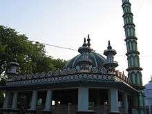
Badi Dargah, the shrine of the Sufi saint Sheikh Makhdoom Sharfuddin Ahmed Yahya Maneri, is located near the ruins of Odantapuri. He is credited with converting many Hindus in the districts of Patna, Bihar Sharif, Gaya, Jehanabad, Arwal, Nawada, Jamui and Sheikhpura, and many Muslims celebrate Urs at the shrine each year in the month of Shawwal on the hijri calendar.
Attractions
Badi Dargah
The resting place of Sufi saint Sheikh Makhdoom Sharfuddin Ahmed Yahya Maneri. The yearly festival of Urs is organised here. The tomb was completed in 1569.

Akhara of Baba Maniram
This place is notable for the annual Langot Fair. A large temple complex and a beautiful tank is located here. The temple has been visited by many great Indian political leaders.
Tomb of Syed Ibrahim Mallick Baya
The tomb of Syed Ibrahim Mallick Baya is located at the top of Hiranya Parvat. Constructed in 14th century, it is notable for its architecture and for the natural beauty of its surroundings.

Badi Pahari
Majority of tourists visiting Biharsharif are domestic- from other places in Bihar and adjoining states.

Bihar Sharif Museum
A museum opened in 1979 and housing relics and sculptures unearthed from the city and nearby areas.
Vajra Vidya Phulahari Thrangu Monastery
A Buddhist monastery located on NH 20 near Hiranya Parvat.
Mora Talab
A large tank said to be constructed by queen Moora Devi, mother of the Mauryan Emperor Chandragupta Maurya. A Sun Temple is located here.
Nagar Palika Park
Nagar Palika Park: It is a park developed by the Municipal Council of Biharsharif on Badi Pahadi. This park consists of ancient Hanuman Mandir and a Tomb.
Kundalpur(Nalanda)
Shri Kundalpur Digambar Jain Teertha Kshetra is located at a distance of 15 km near the ancient Sun-temple fame village of Bargaon in Nalanda.This is reversed as the birthplace of Lord Mahavira with magnificent Jain marbles temples.
Nearby heritage
The well-known tourist sites of Pawapuri and Nalanda, a UNESCO World Heritage Site, are located near the city. The famous city of Rajgir, one of the most visited places in Bihar is about 25 km from Bihar Sharif.

See also
References
| Wikimedia Commons has media related to Bihar Sharif. |
- ↑ "Buoyed by smart city mission tag, Patna, Muzaffarpur gear up for makeover". hindustantimes.com/. 2017-06-26. Retrieved 2017-06-30.
- 1 2 3 4 5 "Bihar Sharif". Encyclopædia Britannica. Retrieved 19 March 2016.
- ↑ "Odantapuri". Encyclopædia Britannica. Retrieved 19 March 2016.
- 1 2 3 Engineer, Ashgar Ali (16 May 1981). "Biharsharif Carnage: A Field Report". Economic and Political Weekly. 16 (20): 887–889. JSTOR 4369828.
- ↑ "Centre unveils list of 98 smart cities; UP, TN strike it rich". The Hindu. 28 August 2015.
- ↑ http://indianexpress.com/article/india/india-news-india/india-20-smart-cities-list/
- 1 2 3 4 "Biharsharif City Census 2011 data". 2011 Indian Census. Retrieved 27 March 2016.
- ↑ "Census of India 2001: Data from the 2001 Census, including cities, villages and towns (Provisional)". Census Commission of India. Archived from the original on 2004-06-16. Retrieved 2008-11-01.
- ↑ "Census 2011 Bihar Sharif". Census 2011. Retrieved 8 July 2017.
- 1 2 "Plans to build new Houses of Worship announced". Baha'i World News Service. 22 April 2012. Retrieved 25 March 2016.
- ↑ "Most Baha'i Nations (2005)". The Association for Religion Data Archives. Retrieved 23 June 2016.
- ↑ "Iconic "Lotus Temple" focus of worldwide campaign". Bahá'í World News Service. 6 October 2011. Retrieved 25 March 2016.
- ↑ http://nalandacollegebiharsharif.com
- ↑ http://kkuniversity.ac.in
- ↑ http://nalandauniv.edu.in
- ↑ http://vimspawapuri.org/
- ↑ http://sainikschoolnalanda.bih.nic.in
- ↑ http://www.britannica.com/nalanda