Greybull, Wyoming
| Greybull, Wyoming | |
|---|---|
| Town | |
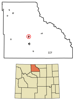 Location of Greybull in Big Horn County, Wyoming. | |
 Greybull, Wyoming Location in the United States | |
| Coordinates: 44°29′29″N 108°3′13″W / 44.49139°N 108.05361°WCoordinates: 44°29′29″N 108°3′13″W / 44.49139°N 108.05361°W | |
| Country | United States |
| State | Wyoming |
| County | Big Horn |
| Area[1] | |
| • Total | 1.83 sq mi (4.74 km2) |
| • Land | 1.82 sq mi (4.71 km2) |
| • Water | 0.01 sq mi (0.03 km2) |
| Elevation | 3,789 ft (1,155 m) |
| Population (2010)[2] | |
| • Total | 1,847 |
| • Estimate (2016)[3] | 1,872 |
| • Density | 1,014.8/sq mi (391.8/km2) |
| Time zone | UTC-7 (Mountain (MST)) |
| • Summer (DST) | UTC-6 (MDT) |
| ZIP code | 82426 |
| Area code(s) | 307 |
| FIPS code | 56-33885[4] |
| GNIS feature ID | 1589144[5] |
Greybull is a town in Big Horn County, Wyoming, United States. The population was 1,847 at the 2010 census.
Geography
Greybull is located at 44°29′29″N 108°3′13″W / 44.49139°N 108.05361°W (44.491450, -108.053655).[6]
According to the United States Census Bureau, the town has a total area of 1.83 square miles (4.74 km2), of which, 1.82 square miles (4.71 km2) of it is land and 0.01 square miles (0.03 km2) is water.[1]
Demographics
| Historical population | |||
|---|---|---|---|
| Census | Pop. | %± | |
| 1910 | 258 | — | |
| 1920 | 2,692 | 943.4% | |
| 1930 | 1,806 | −32.9% | |
| 1940 | 1,828 | 1.2% | |
| 1950 | 2,262 | 23.7% | |
| 1960 | 2,286 | 1.1% | |
| 1970 | 1,953 | −14.6% | |
| 1980 | 2,277 | 16.6% | |
| 1990 | 1,789 | −21.4% | |
| 2000 | 1,815 | 1.5% | |
| 2010 | 1,847 | 1.8% | |
| Est. 2016 | 1,872 | [3] | 1.4% |
| U.S. Decennial Census[7] | |||
2010 census
As of the census[2] of 2010, there were 1,847 people, 778 households, and 488 families residing in the town. The population density was 1,014.8 inhabitants per square mile (391.8/km2). There were 879 housing units at an average density of 483.0 per square mile (186.5/km2). The racial makeup of the town was 92.9% White, 0.4% African American, 1.1% Native American, 0.2% Asian, 0.1% Pacific Islander, 4.5% from other races, and 0.9% from two or more races. Hispanic or Latino of any race were 10.7% of the population.
There were 778 households of which 31.5% had children under the age of 18 living with them, 50.5% were married couples living together, 7.5% had a female householder with no husband present, 4.8% had a male householder with no wife present, and 37.3% were non-families. 31.9% of all households were made up of individuals and 12.6% had someone living alone who was 65 years of age or older. The average household size was 2.37 and the average family size was 3.02.
The median age in the town was 40.1 years. 25.5% of residents were under the age of 18; 7% were between the ages of 18 and 24; 23.3% were from 25 to 44; 28.9% were from 45 to 64; and 15.3% were 65 years of age or older. The gender makeup of the town was 50.9% male and 49.1% female.
2000 census
As of the census[4] of 2000, there were 1,815 people, 781 households, and 500 families residing in the town. The population density was 1,018.4 people per square mile (393.7/km²). There were 923 housing units at an average density of 517.9 per square mile (200.2/km²). The racial makeup of the town was 96.20% White, 0.11% African American, 0.83% Native American, 0.39% Asian, 1.32% from other races, and 1.16% from two or more races. Hispanic or Latino of any race were 4.74% of the population.
There were 781 households out of which 28.6% had children under the age of 18 living with them, 51.7% were married couples living together, 7.6% had a female householder with no husband present, and 35.9% were non-families. 32.0% of all households were made up of individuals and 14.5% had someone living alone who was 65 years of age or older. The average household size was 2.32 and the average family size was 2.92.
In the town, the population was spread out with 26.6% under the age of 18, 7.3% from 18 to 24, 23.5% from 25 to 44, 25.6% from 45 to 64, and 17.1% who were 65 years of age or older. The median age was 40 years. For every 100 females, there were 96.2 males. For every 100 females age 18 and over, there were 95.5 males.
The median income for a household in the town was $29,674, and the median income for a family was $36,964. Males had a median income of $29,063 versus $17,500 for females. The per capita income for the town was $15,383. About 12.0% of families and 14.7% of the population were below the poverty line, including 22.1% of those under age 18 and 12.5% of those age 65 or over.
Education
Public education in the town of Greybull is provided by Big Horn County School District #3. The district has three campuses – Greybull Elementary School (grades K-5), Greybull Middle School (grades 6-8), and Greybull High School (grades 9-12).
Transport
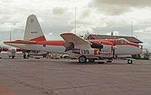
The town is served by the nearby South Big Horn County airport which has been the base for air tankers operating in the forest fire-fighting role, for many years flown by the local firm of Hawkins and Powers, which is now defunct. It is also used for General Aviation operations. Its officially allocated operating call sign code is GEY/KGEY.
Media
The local newspaper is the Greybull Standard. KZMQ-FM and KZMQ (AM) are local radio stations. KROW-FM is a local radio station licensed from nearby Lovell.
Notable residents
- Wilford Brimley, actor[8]
- Jim Crawford, player for the Boston Patriots of the American Football League
- Brett Keisel, former defensive end for the Pittsburgh Steelers
- Bill Wilkinson, former MLB pitcher for the Seattle Mariners
- Tom Wilkinson, player for several teams in the Canadian Football League
References
- 1 2 "US Gazetteer files 2010". United States Census Bureau. Archived from the original on 2012-01-24. Retrieved 2012-12-14.
- 1 2 "American FactFinder". United States Census Bureau. Retrieved 2012-12-14.
- 1 2 "Population and Housing Unit Estimates". Retrieved June 9, 2017.
- 1 2 "American FactFinder". United States Census Bureau. Archived from the original on 2013-09-11. Retrieved 2008-01-31.
- ↑ "US Board on Geographic Names". United States Geological Survey. 2007-10-25. Retrieved 2008-01-31.
- ↑ "US Gazetteer files: 2010, 2000, and 1990". United States Census Bureau. 2011-02-12. Retrieved 2011-04-23.
- ↑ "Census of Population and Housing". Census.gov. Archived from the original on May 12, 2015. Retrieved June 4, 2015.
- ↑ "Brimley purchases property in Big Horn County Archived 2010-07-16 at the Wayback Machine., Lovell Chronicle, July 12, 2007
External links
Municipalities and communities of Big Horn County, Wyoming, United States | ||
|---|---|---|
| Towns | 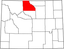 | |
| CDPs | ||
| Unincorporated communities | ||
| Footnotes | ‡This populated place also has portions in an adjacent county or counties | |
| Authority control |
|---|