Betbezer-d'Armagnac
| Betbezer-d'Armagnac | |
|---|---|
| Commune | |
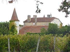 Chateau | |
 Betbezer-d'Armagnac Location within Nouvelle-Aquitaine region  Betbezer-d'Armagnac | |
| Coordinates: 43°58′40″N 0°10′12″W / 43.9778°N 0.17°WCoordinates: 43°58′40″N 0°10′12″W / 43.9778°N 0.17°W | |
| Country | France |
| Region | Nouvelle-Aquitaine |
| Department | Landes |
| Arrondissement | Mont-de-Marsan |
| Canton | Haute Lande Armagnac |
| Intercommunality | Gabardan |
| Government | |
| • Mayor (2014–2020) | Gérard Talès |
| Area1 | 8.1 km2 (3.1 sq mi) |
| Population (2013)2 | 139 |
| • Density | 17/km2 (44/sq mi) |
| Time zone | UTC+1 (CET) |
| • Summer (DST) | UTC+2 (CEST) |
| INSEE/Postal code | 40039 /40240 |
| Elevation |
78–144 m (256–472 ft) (avg. 120 m or 390 ft) |
|
1 French Land Register data, which excludes lakes, ponds, glaciers > 1 km2 (0.386 sq mi or 247 acres) and river estuaries. 2 Population without double counting: residents of multiple communes (e.g., students and military personnel) only counted once. | |
Betbezer-d'Armagnac is a commune in the Landes department in Nouvelle-Aquitaine in southwestern France.
Population
| Historical population | ||
|---|---|---|
| Year | Pop. | ±% |
| 1962 | 128 | — |
| 1968 | 153 | +19.5% |
| 1975 | 170 | +11.1% |
| 1982 | 155 | −8.8% |
| 1990 | 135 | −12.9% |
| 1999 | 106 | −21.5% |
| 2006 | 134 | +26.4% |
| 2013 | 139 | +3.7% |
See also
References
| Wikimedia Commons has media related to Betbezer-d'Armagnac. |
This article is issued from
Wikipedia.
The text is licensed under Creative Commons - Attribution - Sharealike.
Additional terms may apply for the media files.