Berrien County, Michigan
| Berrien County, Michigan | ||
|---|---|---|
 | ||
| ||
 Location in the U.S. state of Michigan | ||
 Michigan's location in the U.S. | ||
| Founded |
29 October 1829 (created) 1831 (organized)[1] | |
| Named for | John M. Berrien | |
| Seat | St. Joseph | |
| Largest city | Niles | |
| Area | ||
| • Total | 1,581 sq mi (4,095 km2) | |
| • Land | 568 sq mi (1,471 km2) | |
| • Water | 1,014 sq mi (2,626 km2), 64% | |
| Population (est.) | ||
| • (2017) | 154,259 | |
| • Density | 272/sq mi (105/km2) | |
| Congressional district | 6th | |
| Time zone | Eastern: UTC−5/−4 | |

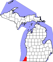
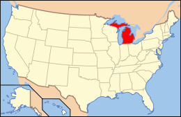
Berrien County is a county on the south line of Michigan, at the southwestern corner of the state. As of the 2010 census, the population was 156,813.[2] The county seat is St. Joseph.[3]
Berrien County is included in the Niles-Benton Harbor, MI Metropolitan Statistical Area, which is also included in the South Bend-Elkhart-Mishawaka, IN-MI Combined Statistical Area.
History
As one of the Cabinet counties, Berrien County was named for John M. Berrien of Georgia, US Attorney General (1829–1831) under US President Andrew Jackson.[1] The county was founded in 1829, and was organized in 1831, before Michigan was accepted into the Union as a state.[4]
When Michigan Territory was established in 1805, the area of present Berrien County was included in the boundary of Wayne County.
About 1780, New Jersey resident William Burnett established a trading post at the mouth of the St. Joseph River (present-day site of St. Joseph) to serve indigenous peoples and French Canadian residents. Also during that time, Joseph Bertrand established a trading post on the river, in present–day Niles Charter Township.[5] In December 1822, missionary Isaac McCoy moved his family and 18 Indian students from Indiana to the St. Joseph River near present-day Niles, Michigan, to open a religious mission (the Carey Mission) to the Potawatomi Indians,160 km from the nearest White settlement.[6]
In 1827 St. Joseph Township was organized as part of Wayne County, It included all lands acquired from the Native Americans by the 1821 Treaty of Chicago.
The boundary of Berrien County was delineated by the Michigan Territory Legislature on 29 October 1829 with its present limits. For purposes of revenue, taxation and judicial matters, it was attached to Cass County, and was designated as Niles Township. This assignation was terminated in 1831 when Berrien County's government was organized and initiated.
Berrien County began with three townships:
- Berrien Township – consisted of present-day townships of Berrien, Oronoko, and Lake plus a two-mile strip north of that territory
- St. Joseph Township – consisted of the area north of Berrien Township
- Niles Township – consisted of the area south of Berrien Township.[7]
Politics
Berrien County has favored a Republican Party candidate in all but six elections since 1884.
| Year | Republican | Democratic | Third Parties |
|---|---|---|---|
| 2016 | 53.7% 38,647 | 41.0% 29,495 | 5.4% 3,889 |
| 2012 | 52.5% 38,209 | 46.0% 33,465 | 1.5% 1,088 |
| 2008 | 46.4% 36,130 | 51.9% 40,381 | 1.7% 1,323 |
| 2004 | 55.0% 41,076 | 44.0% 32,846 | 1.0% 749 |
| 2000 | 54.7% 35,689 | 43.2% 28,152 | 2.2% 1,400 |
| 1996 | 47.7% 28,254 | 41.5% 24,614 | 10.8% 6,427 |
| 1992 | 42.0% 29,252 | 37.1% 25,840 | 20.9% 14,523 |
| 1988 | 62.8% 37,799 | 36.5% 21,948 | 0.7% 436 |
| 1984 | 66.6% 43,160 | 32.8% 21,228 | 0.7% 436 |
| 1980 | 61.0% 41,458 | 32.6% 22,152 | 6.4% 4,368 |
| 1976 | 61.1% 40,835 | 37.7% 25,163 | 1.2% 800 |
| 1972 | 68.3% 43,047 | 29.5% 18,597 | 2.3% 1,416 |
| 1968 | 51.1% 32,136 | 33.8% 21,266 | 15.1% 9,514 |
| 1964 | 43.9% 26,387 | 55.9% 33,653 | 0.2% 122 |
| 1960 | 60.9% 37,425 | 38.8% 23,837 | 0.4% 244 |
| 1956 | 65.5% 35,397 | 34.2% 18,454 | 0.4% 194 |
| 1952 | 62.9% 32,932 | 36.5% 19,088 | 0.6% 300 |
| 1948 | 58.9% 22,003 | 38.9% 14,516 | 2.3% 842 |
| 1944 | 60.7% 24,832 | 38.8% 15,886 | 0.5% 216 |
| 1940 | 57.0% 22,778 | 42.5% 16,961 | 0.5% 208 |
| 1936 | 41.3% 15,321 | 56.1% 20,822 | 2.7% 982 |
| 1932 | 42.5% 14,123 | 55.5% 18,447 | 2.1% 694 |
| 1928 | 68.6% 19,064 | 30.8% 8,555 | 0.6% 172 |
| 1924 | 63.7% 15,612 | 18.2% 4,445 | 18.1% 4,440 |
| 1920 | 74.1% 15,748 | 22.8% 4,855 | 3.1% 662 |
| 1916 | 53.7% 7,511 | 43.3% 6,054 | 3.0% 426 |
| 1912 | 23.1% 2,752 | 35.4% 4,225 | 41.5% 4,958 |
| 1908 | 58.1% 7,260 | 36.8% 4,598 | 5.2% 645 |
| 1904 | 63.0% 7,309 | 32.9% 3,819 | 4.1% 476 |
| 1900 | 55.5% 6,595 | 41.7% 4,960 | 2.8% 334 |
| 1896 | 56.1% 6,672 | 40.3% 4,792 | 3.6% 424 |
| 1892 | 48.6% 4,979 | 46.0% 4,716 | 5.5% 561 |
| 1888 | 49.7% 5,128 | 45.5% 4,689 | 4.8% 497 |
| 1884 | 48.1% 4,445 | 48.2% 4,458 | 3.7% 345 |
Government
The county government operates the jail, maintains rural roads, operates the major local courts, records deeds, mortgages and vital records, oversees public health, and participates with the state in welfare and social services. The county board of commissioners controls the budget and has limited authority to make laws and ordinances. In Michigan, most local government functions — police, fire, building and zoning, tax assessment, street maintenance, etc. — are the responsibility of individual cities and townships.
Elected officials
- Prosecuting Attorney: Mike Sepic
- Sheriff: L. Paul Bailey
- County Clerk: Sharon Tyler
- County Treasurer: Bret E. Witkowski
- Register of Deeds: Lori D. Jarvis
- Drain Commissioner: Christopher J. Quattrin[9]
- County Surveyor: John G. Kamer
(information as of June 2013)
Geography
According to the US Census Bureau, the county has a total area of 1,581 square miles (4,090 km2), of which 568 square miles (1,470 km2) is land and 1,014 square miles (2,630 km2) (64%) is water.[10]
The county borders the state of Indiana to the South and includes a portion of Lake Michigan to the West.
The St. Joseph River is a major geographical feature, flowing mostly north and west through the county from Niles to its mouth on Lake Michigan at St. Joseph. The southwest of the county is drained by the Galien River and its tributaries. Paw Paw Lake is in the north of the county, along with the Paw Paw River, which flows into the St. Joseph River just before it enters Lake Michigan. A tiny portion along the Indiana state line is drained by small tributaries of the Kankakee River, which ultimately flows into the Mississippi River. This is one of two areas of Michigan drained by the Mississippi River, the other being an area of Michigan's Upper Peninsula near the Wisconsin border.
Major highways


Adjacent counties
- Van Buren County – north and northeast
- Cass County – east
- St. Joseph County, Indiana – southeast
- LaPorte County, Indiana – south
- Porter County, Indiana – southwest
- Cook County, Illinois – west
- Lake County, Illinois – northwest
Demographics
| Historical population | |||
|---|---|---|---|
| Census | Pop. | %± | |
| 1830 | 325 | — | |
| 1840 | 5,011 | 1,441.8% | |
| 1850 | 11,417 | 127.8% | |
| 1860 | 22,378 | 96.0% | |
| 1870 | 35,104 | 56.9% | |
| 1880 | 36,785 | 4.8% | |
| 1890 | 41,285 | 12.2% | |
| 1900 | 49,165 | 19.1% | |
| 1910 | 53,622 | 9.1% | |
| 1920 | 62,653 | 16.8% | |
| 1930 | 81,066 | 29.4% | |
| 1940 | 89,117 | 9.9% | |
| 1950 | 115,702 | 29.8% | |
| 1960 | 149,865 | 29.5% | |
| 1970 | 163,875 | 9.3% | |
| 1980 | 171,276 | 4.5% | |
| 1990 | 161,378 | −5.8% | |
| 2000 | 162,453 | 0.7% | |
| 2010 | 156,813 | −3.5% | |
| Est. 2017 | 154,259 | [11] | −1.6% |
| US Decennial Census[12] 1790-1960[13] 1900-1990[14] 1990-2000[15] 2010-2013[2] | |||
The 2010 United States Census[16] indicates Berrien County had a 2010 population of 156,813. This is a decrease of 5,640 people from the 2000 United States Census, or a 3.5% population decrease. In 2010 there were 63,054 households and 41,585 families in the county. The population density was 276.2 per square mile (106.6 square kilometers). There were 76,922 housing units at an average density of 135.5 per square mile (52.3 square kilometers). 78.3% of the population were White, 15.3% Black or African American, 1.6% Asian, 0.5% Native American, 0.1% Pacific Islander, 1.8% of some other race and 2.4% of two or more races. 4.5% were Hispanic or Latino (of any race). 29.0% were of German, 7.4% Irish, 6.8% English and 5.5% American ancestry.[17]
There were 63,054 households, 29.6% of which had children under the age of 18 living with them, 47.8% were husband and wife families, 13.6% had a female householder with no husband present, 34.0% were non-families, and 28.7% were made up of individuals. The average household size was 2.43 and the average family size was 2.98.
The county population contained 23.4% under age of 18, 8.5% from 18 to 24, 23.2% from 25 to 44, 28.6% from 45 to 64, and 16.3% who were 65 years of age or older. The median age was 41 years. For every 100 females there were 94.9 males. For every 100 females age 18 and over, there were 91.6 males.
The 2010 American Community Survey 1-year estimate[18] indicates the median income for a household in the county was $40,329 and the median income for a family was $51,305. Males had a median income of $26,745 versus $16,289 for females. The per capita income for the county was $22,337. About 12.1% of families and 16.8% of the population were below the poverty line, including 28.5% of those under the age 18 and 8.3% of those age 65 or over.
Recreation
State parks
Other parks
- Galien River County Park Preserve
- Kiwanis Park – St. Joseph
- Love Creek County Park
- Madeline Bertrand County Park
- Riverview Park – St. Joseph
- Rocky Gap County Park
- Silver Beach County Park
Resorts and beaches
- Hagar Park – Hagar Township
- Jean Klock Park - Benton Harbor
- Lion’s Park Beach – St. Joseph
- New Buffalo Beach Park – New Buffalo
- Paw Paw Lake
- Rocky Gap Beach Park - Benton Harbor
- Silver Beach - St. Joseph
- Tiscornia Park
- Weko Beach - Bridgman
Golf courses
- Harbor Shores Golf Club - Benton Harbor
- Berrien Hills Country Club – Benton Harbor
- Blossom Trails Golf Club – Benton Harbor
- Brookwood Golf Course - Buchanan
- Lake Michigan Hills Golf Club - Benton Harbor
- Lost Dunes Golf Club - Bridgman
- Milan Creek Golf Club - Baroda
- Orchard Hills Country Club - Buchanan
- Paw Paw Lake Golf Club - Coloma/Watervliet
- Pebble Wood Country Club - Bridgman
- Point O'Woods Golf & Country Club - Benton Harbor
Wineries
- 12 Corners Vineyards - Benton Harbor
- Baroda Founders Wine Cellar - Baroda
- Contessa Wine Cellars - Coloma
- Dablon Winery and Vineyard - Baroda
- Domaine Berrien Cellars – Berrien Springs
- Free Run Cellars - Berrien Springs
- Gravity - Baroda
- Hickory Creek Winery - Buchanan
- Karma Vista Vineyards - Coloma
- Lazy Ballerina Winery - St. Joseph
- Lemon Creek Winery – Berrien Springs
- Round Barn Winery, Distillery & Brewery - Baroda
- Tabor Hill Winery and Restaurant - Buchanan
- White Pine Winery - St. Joseph
- Vineyard 2121 - Benton Harbor
- Red Top Winery - Baroda
Communities
Cities
- Benton Harbor
- Bridgman
- Buchanan
- Coloma
- New Buffalo
- Niles
- St. Joseph (county seat)
- Watervliet
Villages
Census-designated places
Unincorporated communities
Townships
- Bainbridge Township
- Baroda Township
- Benton Charter Township
- Berrien Township
- Bertrand Township
- Buchanan Township
- Chikaming Township
- Coloma Charter Township
- Galien Township
- Hagar Township
- Lake Charter Township
- Lincoln Charter Township
- New Buffalo Township
- Niles Charter Township
- Oronoko Charter Township
- Pipestone Township
- Royalton Township
- Sodus Township
- St. Joseph Charter Township
- Three Oaks Township
- Watervliet Charter Township
- Weesaw Township
See also
References
- 1 2 "Bibliography on Berrien County". Clarke Historical Library, Central Michigan University. Archived from the original on 13 March 2012. Retrieved 19 January 2013.
- 1 2 "State & County QuickFacts". US Census Bureau. Archived from the original on 7 July 2011. Retrieved 26 August 2013.
- ↑ "Find a County". National Association of Counties. Archived from the original on 31 May 2011. Retrieved 7 June 2011.
- ↑ "The History of Berrien County, Michigan". Southwest Michigan Business & Tourism Directory. Archived from the original on 6 October 2014. Retrieved 2 October 2014.
- ↑ Coolidge, Orville W. (1906). A Twentieth Century History of Berrien County Michigan, pp. 19-20. The Lewis Publishing Company.
- ↑ ”Rev. Isaac McCoy” "Archived copy". Archived from the original on 20 November 2010. Retrieved 27 February 2011. , accessed 19 February 2011
- ↑ Coolidge (1906), p. 24.
- ↑ Leip, David. "Dave Leip's Atlas of US Presidential Elections". uselectionatlas.org. Archived from the original on 23 March 2018. Retrieved 5 May 2018.
- ↑ "Archived copy". Archived from the original on 23 October 2017. Retrieved 22 October 2017.
- ↑ "2010 Census Gazetteer Files". US Census Bureau. 22 August 2012. Archived from the original on 13 November 2013. Retrieved 19 September 2014.
- ↑ "American FactFinder". Archived from the original on 8 January 2017. Retrieved 22 March 2018.
- ↑ "US Decennial Census". US Census Bureau. Archived from the original on 12 May 2015. Retrieved 19 September 2014.
- ↑ "Historical Census Browser". University of Virginia Library. Archived from the original on 16 August 2012. Retrieved 19 September 2014.
- ↑ "Population of Counties by Decennial Census: 1900 to 1990". US Census Bureau. Archived from the original on 15 February 2015. Retrieved 19 September 2014.
- ↑ "Census 2000 PHC-T-4. Ranking Tables for Counties: 1990 and 2000" (PDF). US Census Bureau. Archived (PDF) from the original on 18 December 2014. Retrieved 19 September 2014.
- ↑ "American Factfinder". US Census Bureau. Archived from the original on 20 June 2011. Retrieved 11 March 2012.
- ↑ Bureau, US Census. "American FactFinder". factfinder2.census.gov. Archived from the original on 20 June 2011. Retrieved 5 May 2018.
- ↑ "American Factfinder". US Census Bureau. Archived from the original on 20 June 2011. Retrieved 11 March 2012.
External links
- Berrien County government – official web site
- Berrien County Health Department
- Berrien County Road Department
- Berrien County Sheriff's Department
- Berrien County GenGuide for Berrien County Genealogy Information
- "Bibliography on Berrien County". Clarke Historical Library, Central Michigan University. Archived from the original on 13 March 2012.
- History of Berrien and Van Buren counties, Michigan (Ensign, 1880)
- History of Berrien County (Southwest Michigan Directory)
Places adjacent to Berrien County, Michigan | |
|---|---|
Municipalities and communities of Berrien County, Michigan, United States | ||
|---|---|---|
| Cities | | |
| Villages | ||
| Charter townships | ||
| General law townships | ||
| CDPs | ||
| Other unincorporated communities | ||
| Footnotes | ‡This populated place also has portions in an adjacent county or counties | |