Livingston County, Michigan
| Livingston County, Michigan | |
|---|---|
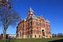 Livingston County Courthouse, Howell | |
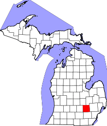 Location in the U.S. state of Michigan | |
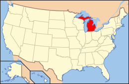 Michigan's location in the U.S. | |
| Founded |
1833 (authorized) 1836 (organized)[1] |
| Named for | Edward Livingston |
| Seat | Howell |
| Largest city | Howell |
| Area | |
| • Total | 585 sq mi (1,515 km2) |
| • Land | 565 sq mi (1,463 km2) |
| • Water | 20 sq mi (52 km2), 3.4% |
| Population | |
| • (2010) | 180,967 |
| • Density | 320/sq mi (120/km2) |
| Congressional district | 8th |
| Time zone | Eastern |
Livingston County is a county located in the U.S. state of Michigan. As of the 2010 census, the population was 180,967.[2] It is included in the Detroit-Warren-Dearborn, MI Metropolitan Statistical Area.
The county seat and most populous city is Howell.[3] The county was platted in 1833, but for three years remained assigned to Shiawassee and Washtenaw counties for revenue, taxation and judicial matters. It was formally organized in 1836. As one of Michigan's "Cabinet counties", a group of ten counties whose names honor members of President Andrew Jackson's Cabinet, it is named after former US Secretary of State Edward Livingston.[1]
Livingston County's location in Southeast Michigan offers its residents relatively convenient access to the major metropolitan centers of Detroit, Lansing, Ann Arbor, and Flint. Livingston County residents regularly commute to those centers, using the three major expressways which pass through the county: I-96, US 23, and M-59.
Although continuing to be composed largely of bedroom communities, the county is experiencing and maintaining significant growth in both the service and industrial economic sectors. Major employers include Tribar, Pepsico, Citizens Insurance, and ThaiSummit. The Brighton Recreation Area is located in the county.
Geography
According to the US Census Bureau, the county has a total area of 585 square miles (1,520 km2), of which 565 square miles (1,460 km2) is land and 20 square miles (52 km2) (3.4%) is water.[4]
Adjacent counties
- Shiawassee County – northwest
- Genesee County - northeast
- Oakland County - east
- Washtenaw County - south
- Jackson County - southwest
- Ingham County – west
Communities
Cities
Villages
Census-designated place
- Whitmore Lake (partial)
Unincorporated communities
- Anderson
- Bullis Crossing
- Chalkerville
- Chilson
- Cohoctah
- Cohoctah Center
- Deer Creek
- Deerfield Center
- Fleming
- Green Oak
- Gregory
- Hallers Corners
- Hamburg
- Hell
- Island Lake
- Kaiserville
- Lakeland
- Nicholson (partial)
- Oak Grove
- Parkers Corners
- Parshallville
- Plainfield
- Pettysville
- Rushton
- Tyrone Center
- Unadilla
- Williamsville
Townships
Major highways


Demographics
| Historical population | |||
|---|---|---|---|
| Census | Pop. | %± | |
| 1840 | 7,430 | — | |
| 1850 | 13,485 | 81.5% | |
| 1860 | 16,851 | 25.0% | |
| 1870 | 19,336 | 14.7% | |
| 1880 | 22,251 | 15.1% | |
| 1890 | 20,858 | −6.3% | |
| 1900 | 19,664 | −5.7% | |
| 1910 | 17,736 | −9.8% | |
| 1920 | 17,522 | −1.2% | |
| 1930 | 19,274 | 10.0% | |
| 1940 | 20,863 | 8.2% | |
| 1950 | 26,725 | 28.1% | |
| 1960 | 38,233 | 43.1% | |
| 1970 | 58,967 | 54.2% | |
| 1980 | 100,289 | 70.1% | |
| 1990 | 115,645 | 15.3% | |
| 2000 | 156,951 | 35.7% | |
| 2010 | 180,967 | 15.3% | |
| Est. 2016 | 188,624 | [5] | 4.2% |
| US Decennial Census[6] 1790-1960[7] 1900-1990[8] 1990-2000[9] 2010-2013[2] | |||
As of the 2000 United States Census,[10] of 2010, there were 180,967 people, 55,384 households, and 43,531 families residing in the county. The population density was 320 people per square mile (107/km²). There were 58,919 housing units at an average density of 104 per square mile (40/km²). 96.7% of the population were White, 0.8% Asian, 0.4% Black or African American, 0.4% Native American, 0.4% of some other race and 1.3% of two or more races. 1.9% were Hispanic or Latino (of any race). 20.8% were of German, 11.2% Irish, 10.6% English, 10.6% Polish, 6.5% American, 5.2% Italian and 5.1% French, French Canadian or Cajun ancestry. 95.9% spoke English and 1.7% Spanish as their first language.[11]
There were 55,384 households out of which 39.80% had children under the age of 18 living with them, 68.50% were married couples living together, 6.80% had a female householder with no husband present, and 21.40% were non-families. 17.10% of all households were made up of individuals and 5.40% had someone living alone who was 65 years of age or older. The average household size was 2.80 and the average family size was 3.18.
The county population contained 28.80% under the age of 18, 6.60% from 18 to 24, 31.70% from 25 to 44, 24.60% from 45 to 64, and 8.30% who were 65 years of age or older. The median age was 36 years. For every 100 females, there were 102.10 males. For every 100 females age 18 and over, there were 99.70 males.
With a median household income of $67,400 (2008 estimate - $72,700) and a median family income of $75,284, Livingston county is one of the Highest-income counties in the United States and the 2nd highest-income county in Michigan (after Oakland). Males had a median income of $54,358 versus $32,073 for females. The per capita income for the county was $28,069. About 2.40% of families and 3.40% of the population were below the poverty line, including 3.60% of those under age 18 and 4.50% of those age 65 or over.
More than 50% of the population of the county is located in the southeastern communities of Brighton Township, Genoa Township, Hamburg Township, Green Oak Township, the Village of Pinckney, Putnam Township and the city of Brighton.
The US Census Bureau in 2000 identified Brighton, Howell and the nearby city of South Lyon to be a contiguously-urbanized area, one of the newest such areas in the United States.
Media
There are currently two local newspapers, the Livingston County Daily Press & Argus, owned by Gannett Company, and The Community Journal, which is an independently owned weekly.
The Daily Press & Argus, which publishes daily except Saturday, was launched in 2000 through the combination of two weekly newspapers, The Livingston County Press and The Brighton Argus, which served the communities for many decades.
The Community Journal was launched in February 2010 by Steve Horton and Buddy Moorehouse, two veteran newspapermen. It publishes Tuesdays, covering Pinckney, Fowlerville, and the Howell areas. Its editor is Stephenie Koehn. The Journal is published along with the Fowlerville News and Views, which has been published for 25 years by Horton and his wife Dawn.
A weekly all-local paper,The Livingston Community News, was launched in May 2003 with offices in downtown Brighton and was closed in July 2009 when "The Ann Arbor News, the newspaper's parent company, ceased publication. Community Journal editor Koehn was a reporter with The Livingston Community News.
Other media in the county include WHMI-FM, a Classic Hits radio station that has local news on the hour, and www.LivingstonTalk.com, a web-based product launched in the fall of 2009 by Moorehouse and fellow veteran journalist Maria Stuart. Moorehouse and Stuart previously worked as editors for a combined 45 years at the Daily Press and Argus.
The Marketeer is a free monthly magazine that is mailed to more than 42,000 in Livingston County. Its content is primarily advertising from local businesses plus articles and information about people and community events. The Marketeer has been published by George Moses Company since 1974.
Politics
Livingston County has been reliably Republican since the beginning. Since 1884, the Republican Party nominee has carried 82% of the elections (28 of 34).
In 2008, Republican John McCain received 55,592 votes (55.6% of the county's vote) to 42,349 (42.4%) for Democrat Barack Obama, even as Obama carried the state by a double-digit margin.[12] Democrats last carried the county in 1964.
In 2004, Republican George W. Bush easily won the county, receiving 58,860 votes (62.8%) to 33,991 (36.2%) for Democrat John Kerry. [13]
In 2000, George W. Bush received 44,637 votes (59.1%) to 28,780 (38.1%) for Democrat Al Gore.[14]
In 1996, Republican Bob Dole received 30,598 votes (50.8%) to 22,517 (37.4%) to Democrat Bill Clinton, who carried the state by a double-digit margin.[15]
In 1992, Republican George H.W. Bush received 27,539 votes (44.6%) to Clinton's 17,851 (28.9%), while independent Ross Perot received 15,971 (25.9%).[16]
In 1988, George H.W. Bush received 31,331 votes (68.8%) to 13,749 (30.2%) for Democrat Michael Dukakis.[17]
In 1984, Republican Ronald Reagan received 31,846 votes (74.4%) to 10,720 (25.0%) for Democrat Walter Mondale[18]
| Year | Republican | Democratic | Third Parties |
|---|---|---|---|
| 2016 | 61.7% 65,680 | 32.3% 34,384 | 6.0% 6,425 |
| 2012 | 60.9% 60,083 | 37.7% 37,216 | 1.4% 1,341 |
| 2008 | 55.6% 55,592 | 42.4% 42,349 | 2.0% 1,965 |
| 2004 | 62.8% 58,860 | 36.3% 33,991 | 1.0% 891 |
| 2000 | 59.1% 44,637 | 38.1% 28,780 | 2.7% 2,058 |
| 1996 | 50.8% 30,598 | 37.4% 22,517 | 11.8% 7,127 |
| 1992 | 44.6% 27,539 | 28.9% 17,851 | 26.5% 16,345 |
| 1988 | 68.8% 31,331 | 30.2% 13,749 | 1.0% 466 |
| 1984 | 74.4% 31,846 | 25.0% 10,720 | 0.6% 246 |
| 1980 | 60.2% 25,012 | 30.4% 12,626 | 9.5% 3,932 |
| 1976 | 59.8% 19,437 | 38.2% 12,415 | 2.0% 634 |
| 1972 | 66.9% 16,856 | 30.3% 7,634 | 2.9% 725 |
| 1968 | 51.0% 10,034 | 35.9% 7,052 | 13.1% 2,584 |
| 1964 | 40.9% 6,723 | 59.0% 9,698 | 0.1% 20 |
| 1960 | 64.7% 10,340 | 35.1% 5,608 | 0.2% 39 |
| 1956 | 72.6% 10,315 | 27.1% 3,845 | 0.3% 45 |
| 1952 | 75.6% 9,790 | 23.8% 3,086 | 0.6% 79 |
| 1948 | 71.0% 7,368 | 27.1% 2,813 | 1.9% 198 |
| 1944 | 71.4% 7,417 | 28.0% 2,910 | 0.6% 64 |
| 1940 | 68.3% 7,068 | 31.4% 3,254 | 0.3% 34 |
| 1936 | 53.5% 5,117 | 43.1% 4,117 | 3.4% 329 |
| 1932 | 48.5% 4,534 | 50.1% 4,684 | 1.5% 139 |
| 1928 | 72.9% 5,642 | 26.8% 2,075 | 0.3% 24 |
| 1924 | 67.4% 4,886 | 28.1% 2,037 | 4.5% 329 |
| 1920 | 64.1% 4,639 | 33.7% 2,437 | 2.2% 161 |
| 1916 | 50.9% 2,460 | 47.5% 2,297 | 1.6% 78 |
| 1912 | 28.5% 1,408 | 39.7% 1,960 | 31.9% 1,574 |
| 1908 | 50.8% 2,740 | 44.8% 2,418 | 4.3% 234 |
| 1904 | 60.3% 3,288 | 36.5% 1,988 | 3.2% 175 |
| 1900 | 49.7% 2,860 | 47.4% 2,727 | 2.9% 168 |
| 1896 | 47.7% 2,893 | 49.4% 2,994 | 3.0% 179 |
| 1892 | 43.8% 2,447 | 42.7% 2,385 | 13.6% 760 |
| 1888 | 45.0% 2,706 | 47.3% 2,842 | 7.8% 467 |
| 1884 | 44.7% 2,597 | 50.6% 2,938 | 4.7% 272 |
County government
The county government operates the jail, maintains rural roads, operates the major local courts, records deeds, mortgages, and vital records, administers public health regulations, and participates with the state in the provision of social services. The county board of commissioners controls the budget and has limited authority to make laws or ordinances. In Michigan, most local government functions – police and fire, building and zoning, tax assessment, street maintenance, etc. – are the responsibility of individual cities and townships.
Elected officials
- Prosecuting Attorney: William Vailliencourt
- Sheriff: Michael Murphy
- County Clerk: Betsy Hundley
- County Treasurer: Jennifer Nash
- Register of Deeds: Brandon Denby
- Drain Commissioner: Brian Jonckheere
(information as of October 2016)
See also
References
- 1 2 "Bibliography on Livingston County". Clarke Historical Library, Central Michigan University. Archived from the original on 17 February 2013. Retrieved 20 January 2013.
- 1 2 "State & County QuickFacts". US Census Bureau. Archived from the original on 14 July 2011. Retrieved 28 August 2013.
- ↑ "Find a County". National Association of Counties. Archived from the original on 12 July 2012. Retrieved 7 June 2011.
- ↑ "2010 Census Gazetteer Files". US Census Bureau. 22 August 2012. Archived from the original on 13 November 2013. Retrieved 26 September 2014.
- ↑ "Population and Housing Unit Estimates". Archived from the original on 29 May 2017. Retrieved 9 June 2017.
- ↑ "US Decennial Census". US Census Bureau. Archived from the original on 12 May 2015. Retrieved 26 September 2014.
- ↑ "Historical Census Browser". University of Virginia Library. Archived from the original on 16 August 2012. Retrieved 26 September 2014.
- ↑ "Population of Counties by Decennial Census: 1900 to 1990". US Census Bureau. Archived from the original on 15 February 2015. Retrieved 26 September 2014.
- ↑ "Census 2000 PHC-T-4. Ranking Tables for Counties: 1990 and 2000" (PDF). US Census Bureau. Archived (PDF) from the original on 18 December 2014. Retrieved 26 September 2014.
- ↑ "American FactFinder". US Census Bureau. Archived from the original on 11 September 2013. Retrieved 31 January 2008.
- ↑ Data Access and Dissemination Systems (DADS). "American FactFinder". Archived from the original on 17 February 2012.
- ↑ "Archived copy" (PDF). Archived from the original (PDF) on 8 June 2011. Retrieved 20 April 2010.
- ↑ "Archived copy" (PDF). Archived from the original (PDF) on 9 June 2011. Retrieved 20 April 2010.
- ↑ "Dave Leip's Atlas of US Presidential Elections - State Data". Uselectionatlas.org. Archived from the original on 7 June 2011. Retrieved 22 July 2010.
- ↑ "Dave Leip's Atlas of US Presidential Elections - Data Graphs". Uselectionatlas.org. Archived from the original on 7 June 2011. Retrieved 22 July 2010.
- ↑ "Dave Leip's Atlas of US Presidential Elections - Data Graphs". Uselectionatlas.org. Archived from the original on 7 June 2011. Retrieved 22 July 2010.
- ↑ "Dave Leip's Atlas of US Presidential Elections - Data Graphs". Uselectionatlas.org. Archived from the original on 7 June 2011. Retrieved 22 July 2010.
- ↑ "Dave Leip's Atlas of US Presidential Elections - Data Graphs". Uselectionatlas.org. Archived from the original on 7 June 2011. Retrieved 22 July 2010.
- ↑ Leip, David. "Dave Leip's Atlas of US Presidential Elections". uselectionatlas.org. Archived from the original on 23 March 2018. Retrieved 5 May 2018.
External links
- Livingston County official website

- "Bibliography on Livingston County". Clarke Historical Library, Central Michigan University.
Places adjacent to Livingston County, Michigan | ||||||||||
|---|---|---|---|---|---|---|---|---|---|---|
| ||||||||||
Municipalities and communities of Livingston County, Michigan, United States | ||
|---|---|---|
| Cities | | |
| Villages | ||
| Charter townships | ||
| General law townships | ||
| Unincorporated communities |
| |
| Footnotes | ‡This populated place also has portions in an adjacent county or counties | |
| Topics |  | |
|---|---|---|
| Detroit | ||
| Municipalities over 80,000 | ||
| Municipalities 40,000 to 80,000 | ||
| Cultural enclaves | ||
| Satellite cities | ||
| Counties in MSA | ||
| Counties in CSA | ||