Sarthe (river)
| Sarthe | |
|---|---|
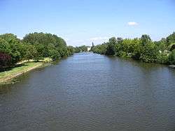 The navigable river Sarthe between Morannes and Chemiré-sur-Sarthe | |
| Native name | La Sarthe |
| Country | France |
| Physical characteristics | |
| Main source |
Perche 250 m (820 ft) |
| River mouth |
Maine 47°29′35″N 0°32′34″W / 47.49306°N 0.54278°WCoordinates: 47°29′35″N 0°32′34″W / 47.49306°N 0.54278°W |
| Length | 313.9 km (195.0 mi) |
| Discharge |
|
| Basin features | |
| Progression | Maine→ Loire→ Atlantic Ocean |
| Basin size | 7,864 km2 (3,036 sq mi)* |
| Notes | *excluding Loir |
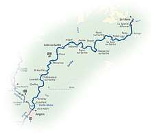
The Sarthe is a 313.9 km (195.0 mi) long river in western France.[1] Together with the river Mayenne it forms the river Maine, which is a tributary to the river Loire.
Its source is in the Orne department, near Moulins-la-Marche. It flows generally southwest, through the following departments and towns:
- Orne: Le Mêle-sur-Sarthe, Alençon
- Sarthe: Fresnay-sur-Sarthe, Beaumont-sur-Sarthe, Le Mans, Sablé-sur-Sarthe
- Maine-et-Loire: Châteauneuf-sur-Sarthe, Tiercé, Angers
Its two main tributaries are the Loir and the Huisne.
The navigable river Sarthe from Le Mans to the confluence with the Mayenne north of Angers

The Sarthe at Le Mans
Navigation
The Sarthe has 20 weirs and locks. The channel is well marked and navigation is straightforward, except for the risk of shoals in certain sections.
External links
- River Sarthe with further maps and expanded details (by the author of 'Inland Waterways of France')
- Navigation details for 80 French rivers and canals (French waterways website section)
| Wikimedia Commons has media related to Sarthe River. |
References
This article is issued from
Wikipedia.
The text is licensed under Creative Commons - Attribution - Sharealike.
Additional terms may apply for the media files.