Lake Singkarak
| Singkarak | |
|---|---|
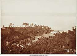 Lake Singkarak and the Ombilin river circa 1900 | |
| Location | West Sumatra, Indonesia |
| Coordinates | 0°37′12″S 100°32′24″E / 0.62000°S 100.54000°ECoordinates: 0°37′12″S 100°32′24″E / 0.62000°S 100.54000°E |
| Type | Tectonic |
| Primary inflows | Sumani River |
| Primary outflows | Ombilin River, Anai River |
| Basin countries | Indonesia |
| Surface area | 107.8 km2 (41.6 sq mi) |
| Average depth | 149 m (489 ft)[1] |
| Max. depth | 268 m (879 ft) |
| Water volume | 16.1 km3 (13,100,000 acre⋅ft) |
| Surface elevation | 362 m (1,188 ft) |
Lake Singkarak (Indonesian: Danau Singkarak) is a lake in West Sumatra, Indonesia. It is located between the cities of Padang Panjang and Solok. It has an area of 107.8 km², being approximately 21 km long and 7 km wide. The natural outlet for excess water is the Ombilin river which flows eastward to the Strait of Malacca. A hydroelectric project, however, has diverted most of the lake outflow to the Anai river which flows westward into the Indian Ocean near Padang. This Singkarak power station uses this water to generate power for the West Sumatra and Riau provinces. A species of fish called ikan bilih (Mystacoleucus padangensis) is endemic to the lake, and is harvested for human consumption. A railway line, which connects Padang and Sawahlunto-Sijunjung, skirts the length of the lake on the eastern side.

See also
Notes
- ↑ Mean depth calculated as volume / surface area.
References
- "Impact evaluation study of Asian Development Bank assistance to the power sector" (PDF). Asian Development Bank. 2003. Archived from the original (PDF) on 2007-05-08. Retrieved 2006-12-24.
- "Special evaluation study on the social and environmental impacts of selected hydropower projects" (PDF). Asian Development Bank. 1999. Retrieved 2006-12-24.
- Farida; et al. (2005). "Rapid Hydrological Appraisal (RHA) of Singkarak Lake in the context of Rewarding Upland Poor for Environmental Services (RUPES)" (PDF). World Agroforestry Centre. Archived from the original (PDF) on 2007-09-28. Retrieved 2006-12-24.
- Rupes Project Team. (2006). "Linking rewards and governance to effects of land use on environmental services at the scale of the lake" (PDF). World Agroforestry Centre. Archived from the original (PDF) on 2007-02-26. Retrieved 2006-12-24.
- Kevin Jeanes; et al. (2006). "Rapid Hydrological Appraisal in the context of environmental service rewards" (PDF). World Agroforestry Centre. Retrieved 2006-12-24.