Tuban Regency
| Tuban Regency Kabupaten Tuban | ||
|---|---|---|
| Regency | ||
| ||
| Motto(s): “Terwujudnya masyarakat Kabupaten Tuban yang mandiri dan sejahtera lahir batin “ (striving to make Tubanese society wholly independent and prosperous) | ||
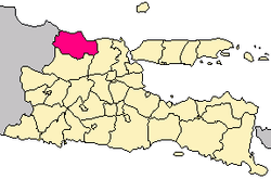 Location within East Java | ||
| Coordinates: 6°53′S 112°03′E / 6.883°S 112.050°ECoordinates: 6°53′S 112°03′E / 6.883°S 112.050°E | ||
| Country |
| |
| Province | East Java | |
| Capital | Tuban | |
| Government | ||
| • Regent | Fathul Huda | |
| • Vice Regent | Noor Nahar Hussein | |
| Area | ||
| • Total | 1,834.15 km2 (708.17 sq mi) | |
| Population (2014) | ||
| • Total | 1,149,882 | |
| • Density | 630/km2 (1,600/sq mi) | |
| Time zone | UTC+7 (IWST) | |
| Area code | (+62) 356 | |
| Website |
tubankab | |


Tuban Regency is a regency in East Java province of Indonesia. The Dutch name of the regency is 'Toeban'. It covers an area of 1,834.15 sq. km, and had a population of 1,118,464 at the 2010 Census;[1] the latest official estimate (as at 2014) is 1,149,882. Tuban is located in a strategic area, on the border of East Java with Central Java, passed by Jalan Nasional Daendels on North Coast of Java (Pantura). Therefore, in ancient times, Tuban was the main port of Majapahit and being a center of Islamic spreading by Walisongo.
Administrative districts
Tuban Regency consists of 20 districts (kecamatan):
- Bancar
- Bangilan
- Grabagan
- Jatirogo
- Jenu
- Kenduruan
- Kerek
- Merakurak
- Montong
- Palang
- Parengan
- Plumpang
- Rengel
- Semanding
- Senori
- Singgahan
- Soko
- Tambakboyo
- Widang
- Grabagan
References
- ↑ Biro Pusat Statistik, Jakarta, 2011.

This article is issued from
Wikipedia.
The text is licensed under Creative Commons - Attribution - Sharealike.
Additional terms may apply for the media files.