Situbondo Regency
| Situbondo Regency Kabupaten Situbondo | ||
|---|---|---|
| Regency | ||
| ||
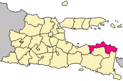 Location within East Java | ||
| Coordinates: 7°42′S 114°00′E / 7.700°S 114.000°ECoordinates: 7°42′S 114°00′E / 7.700°S 114.000°E | ||
| Country |
| |
| Province | East Java | |
| Capital | Situbondo | |
| Government | ||
| • Regent | Dadang Wigiarto | |
| • Vice Regent | Yoyok Mulyadi | |
| Area | ||
| • Total | 1,669.87 km2 (644.74 sq mi) | |
| Population (2014) | ||
| • Total | 665,818 | |
| • Density | 400/km2 (1,000/sq mi) | |
| Time zone | UTC+7 (IWST) | |
| Area code | (+62) 338 | |
| Website |
situbondokab | |

Situbondo Regency is a regency (kabupaten) of East Java province, Indonesia. It covers an area of 1,669.87 km2, and had a population of 647,619 at the 2010 Census;[1] the latest official estimate (as at January 2014) is 665,818. It is located in east end of Java before Banyuwangi. The administrative centre is Situbondo, a small town within the regency. One of the famous tourist sites is Baluran National Park.
Situbondo Harbor
Situbondo has three harbors:
- Panarukan Harbor
- Kalbut Harbor in Semiring districts of Mangaran and
- Jangkar Harbor in Asembagus
Gallery

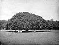 Two groups of men under a large banyan tree in Situbondo
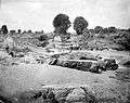 River and washed away bridge in the area of Situbondo
References
- ↑ Biro Pusat Statistik, Jakarta, 2011.

This article is issued from
Wikipedia.
The text is licensed under Creative Commons - Attribution - Sharealike.
Additional terms may apply for the media files.