Mount Rinjani National Park
| Mount Rinjani National Park | |
|---|---|
| Taman Nasional Gunung Rinjani | |
|
IUCN category II (national park) | |
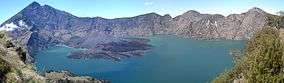 Rinjani caldera | |
 Mount Rinjani NP | |
| Location | Lombok, West Nusa Tenggara, Indonesia |
| Nearest city | Mataram |
| Coordinates | 8°24′29″S 116°24′58″E / 8.40806°S 116.41611°ECoordinates: 8°24′29″S 116°24′58″E / 8.40806°S 116.41611°E |
| Area | 413.30 square kilometres (41,330 ha) |
| Established | 1990 |
| Visitors | 117,715 (in 2007[1]) |
| Governing body | Ministry of Environment and Forestry |
| Website |
www |
Mount Rinjani National Park is located on the island of Lombok, Indonesia in the North Lombok Regency. The park covers about 41,330 hectares (102,100 acres) and consists of mountainous areas. Mount Rinjani (Gunung Rinjani), which is the third highest volcano of Indonesia at 3,726 metres (12,224 ft), is located in this national park, giving this park its name.[2]
Flora and fauna
Some of endangered plants protected in this national park, such as: Pterospermum javanicum,[2] Swietenia macrophylla, Ficus superba, Toona sureni, Vanda sp., Usnea sp and Anaphalis sp.
There are also several endangered fauna protected in this national park, including rusa deer, Indian muntjac, Sunda porcupine, surili monkeys, helmeted friarbird, several cockatoos and scaly-crowned honeyeater.
See also
References
- ↑ Forestry statistics of Indonesia 2007, retrieved 20 May 2010
- 1 2 Ministry of Forestry of Indonesia: "Gunung Rinjani National Park", retrieved 3 December 2013
External links
- Gunung Rinjani National Park
- UNEP-WCMC World Database on Protected Areas: Gunung Rinjani National Park
| Wikimedia Commons has media related to Mount Rinjani National Park. |