Ngawi Regency
| Ngawi Regency | ||
|---|---|---|
| Regency | ||
 The town of Ngawi at night | ||
| ||
| Motto(s): Ramah | ||
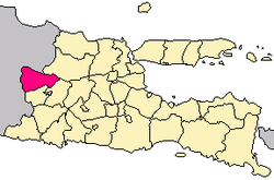 Location within East Java | ||
| Coordinates: 7°24′11″S 111°26′40.7″E / 7.40306°S 111.444639°E | ||
| Country |
| |
| Province |
| |
| Capital | Ngawi | |
| Government | ||
| • Regent | Budi Sulistyono[1] | |
| • Vice Regent | Ony Anwar | |
| Area | ||
| • Total | 1,245.70 km2 (480.97 sq mi) | |
| Population (2010) | ||
| • Total | 879.193 | |
| • Density | 0.71/km2 (1.8/sq mi) | |
| Time zone | UTC+7 (IWST) | |
| Area code | (+62) 351 | |
| Website | ngawikab.go.id | |


Ngawi Regency is a regency (kabupaten) of East Java, Indonesia. Ngawi is well known around the world for its Pithecantropus erectus that was found by Eugene Dubois, a Dutchman. Ngawi is located at the central of East Java province and Central Java province. Ngawi is also the main gate to enter East Java province since there are intersections that connect Surabaya–Madiun–Bojonegoro–Solo–Jogja–Bandung–Jakarta.
Ngawi has the largest central park in Indonesia, called "Alun-Alun". This includes West Park and East Park, which are separated by Merdeka Street. The West Park consists of football court, volleyball court, and a ceremonial podium near the main mosque. The East Hall consists of a playground area, two tennis courts, basket hall, parking area, futsal court, skater area, and culinary area "the most favorite place visited by Ngawinese". The city hall called Alun-Alun Merdeka is located at the central of the Ngawi city.
Besides that, Ngawi also has the largest bus station in Madiun Residency.
Van Den Bosch Fortress is a central historic site of the Ngawi Regency. It is located at the confluence of the two biggest rivers in East Java, Solo River and Madiun River.
The traditional food from Ngawi and originally from Ngawi are Tahu Tepo, Rujak Tahu, Sate Ayam, and Wedang Cemue. Beside that are also Kripik Tempe, Gethi, and Ledre (made from banana). Ngawi has mainly agribusiness. Its watermelon was well known around the nation.
Climate
Ngawi has a tropical climate (Köppen climate classification Cfa) with hot summers and rainy season. Precipitation is significant throughout the year, but is much heavier around the summer, especially the months of June and July.
| Climate data for Ngawi (1981–2010) | |||||||||||||
|---|---|---|---|---|---|---|---|---|---|---|---|---|---|
| Month | Jan | Feb | Mar | Apr | May | Jun | Jul | Aug | Sep | Oct | Nov | Dec | Year |
| Record high °C (°F) | 22.5 (72.5) |
26.4 (79.5) |
27.4 (81.3) |
30.7 (87.3) |
34.4 (93.9) |
36.1 (97) |
38.8 (101.8) |
38.5 (101.3) |
37.0 (98.6) |
33.7 (92.7) |
28.9 (84) |
24.6 (76.3) |
38.8 (101.8) |
| Average high °C (°F) | 10.5 (50.9) |
12.1 (53.8) |
15.7 (60.3) |
21.3 (70.3) |
25.6 (78.1) |
28.2 (82.8) |
31.7 (89.1) |
33.2 (91.8) |
29.9 (85.8) |
24.6 (76.3) |
18.5 (65.3) |
13.0 (55.4) |
22.0 (71.6) |
| Daily mean °C (°F) | 5.7 (42.3) |
7.1 (44.8) |
10.6 (51.1) |
15.7 (60.3) |
20.2 (68.4) |
23.6 (74.5) |
27.3 (81.1) |
28.2 (82.8) |
24.9 (76.8) |
19.1 (66.4) |
13.1 (55.6) |
7.8 (46) |
16.9 (62.4) |
| Average low °C (°F) | 1.2 (34.2) |
2.3 (36.1) |
5.6 (42.1) |
10.3 (50.5) |
15.2 (59.4) |
19.8 (67.6) |
24.0 (75.2) |
24.4 (75.9) |
20.8 (69.4) |
14.2 (57.6) |
8.3 (46.9) |
3.1 (37.6) |
12.5 (54.5) |
| Record low °C (°F) | −9.2 (15.4) |
−9.2 (15.4) |
−6.9 (19.6) |
−2.5 (27.5) |
1.3 (34.3) |
7.1 (44.8) |
14.3 (57.7) |
15.3 (59.5) |
6.7 (44.1) |
0.5 (32.9) |
−3.8 (25.2) |
−7.9 (17.8) |
−9.2 (15.4) |
| Average rainfall mm (inches) | 60.1 (2.366) |
83.3 (3.28) |
137.9 (5.429) |
145.9 (5.744) |
195.5 (7.697) |
404.9 (15.941) |
400.8 (15.78) |
173.5 (6.831) |
170.4 (6.709) |
79.4 (3.126) |
80.6 (3.173) |
53.6 (2.11) |
1,985.9 (78.186) |
| Average rainy days (≥ 0.5 mm) | 8.6 | 9.0 | 12.4 | 10.9 | 11.1 | 14.4 | 13.5 | 10.7 | 10.6 | 6.9 | 7.9 | 8.2 | 124.2 |
| Average relative humidity (%) | 70 | 67 | 67 | 66 | 68 | 75 | 77 | 73 | 72 | 69 | 72 | 71 | 71 |
| Mean monthly sunshine hours | 132.6 | 139.5 | 158.5 | 181.4 | 187.2 | 141.0 | 184.5 | 211.0 | 175.9 | 189.7 | 153.0 | 147.5 | 2,001.8 |
Administration
Ngawi Regency is divided into nineteen[2] districts (kecamatan) and 217 villages.
Trinil Site
Trinil Museum
Trinil Museum is about 15 kilometers from Ngawi city and near to the Bengawan Solo River. The museum contains a collection of about 1,500 fossils, some of which are a million years old. As of 2013 up to 500 fossils had yet to be identified. In the late 19th century Eugene Dubois found Pithecantropus eretus in the Trinil area.
Oldest human-made mark in the world
Researchers found in Trinil site that scratch at Pseudodon vondembuschianus trinilensis plain water clam shell aged 500,000 years is the oldest scratch in the world. Although the scratch is perhaps not art, its zig-zag shape is evidence that the scratch is human made. The clam shell has been found in 1896, but the zig-zag scratch was found in 2014.[3]
References
Coordinates: 7°24′11″S 111°26′40.7″E / 7.40306°S 111.444639°E
External links
- (in Indonesian) Official site