Badghis Province
| Badghis بادغیس | |
|---|---|
| Province | |
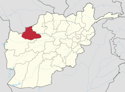 Location within Afghanistan | |
 Districts prior to 2005 realignment | |
| Coordinates: 35°0′N 63°45′E / 35.000°N 63.750°ECoordinates: 35°0′N 63°45′E / 35.000°N 63.750°E | |
| Country |
|
| Provincial seat | Qala i Naw |
| Largest city | Murghab |
| Districts | |
| Area | |
| • Total | 20,590.6 km2 (7,950.1 sq mi) |
| • Water | 0 km2 (0 sq mi) |
| Population (2013)[1] | |
| • Total | 499,393 |
| • Density | 20.9/km2 (54/sq mi) |
| Demographics | |
| • Ethnic groups | Tajik, Pashtun, Uzbek, Turkmen, Hazara |
| • Languages | Dari Persian, Pashto, Turkmen |
| ISO 3166 code | AF-BDG |

Bādghīs (Pashto/Persian: بادغیس) is one of the thirty-four provinces of Afghanistan, located in the northwest of the country next to Turkmenistan. It is counted as one of the most underdeveloped of the country's provinces. The capital is Qala i Naw, while the most populous city and district is Murghab. The ruins of the medieval city of Marw al-Rudh are located in the province near the modern city of Murghab.
Geography
Badghis Province is located in the isolated hills of northwestern Afghanistan and shares its borders with Herat, Ghor, and Faryab provinces as well as Turkmenistan. The province has a total area of 20,591 km2.[2] Hydrologically, the province is dominated by the Murghab River which is used for irrigation.[3]
The province is very windy; the name "Badghis" is a corruption of the Persian compound, bâd-khiz, meaning "wind source", referring to the steppe winds that blow into the province from the north and northwest. Its northern border extends to the edge of the part of the Karakum desert known as the Sarakhs desert. Northern Badghis includes the loess and other aeolian formations, known locally as the chul,[4] through which the Turkmen-Afghan boundary runs.[5] Across the border in Turkministan is the Badkhyz Nature Reserve in the Badkhiz-Karabil semi-desert.[6]
History
Prior to the Arab conquest, the province was the center of the Kingdom of Badghis, whose king Tarkhan Tirek resisted an Umayyad invasion in 709 AD. In 1964, the province was carved out of portions of Herat Province and Meymaneh Province.
The province was one of the last captured by the Taliban in their military offensive before the American invasion in 2001. The province was quickly retaken by Northern Alliance forces as the United States initiated hostilities.
Demography
Like in the rest of Afghanistan, no exact population numbers are available. The Afghan Ministry of Rural Rehabilitation & Development (MRRD) along with UNHCR and Central Statistics Office (CSO) of Afghanistan estimates the population of the province to be around 499,393.[1] According to the same sources, Tajik and Turkic People (Hazara, Uzbek and Turkmen ) make up around 68% of the total population, followed by 19% Pashtuns and 8% Uzbeks and the remaining consists of Turkmens, Balochs and other minorities.[1] According to the United States Naval Postgraduate School, the population of Badghis consists of approximately 62% Tajik, 28% Pashtun (including Durrani), with Hazara, Baloch, Aimak and others.[7]
Politics
The current Governor of the province is Jamaluddin Ishaq.
The major political parties are:[7]
- Jamiat-e Islami (Islamic Society of Afghanistan)
- Hezb-e Islami Gulbuddin (HIG)
- Hizb-i-Wahdat (Mohaqqeq)
- Islamic Council of Herat
At the province was a Provincial Reconstruction Team, which was led by Spain.[7]
Economy
Badghis is counted as one of the most underdeveloped of the country's thirty-four provinces.[8] Not only does it have little infrastructure, and poor roads, it has a chronic stortage of water.[8][9] Agriculture is the main source of people's income and the existence of Murghab, river makes the available land suitable for cultivation. The province has suffered from severe drought beginning in the late 1990s and continuing. It has caused tens of thousands of residents to flee to refugee camps outside Herat.[10] The drought has been exacerbated by excessive cutting of forests since 2001.[9] Badghis is the leading province in Afghanistan in pistachio production. It is also one of the carpet-making areas of the country.
Transportation
Badghis Province suffers from a lack of adequate transportation. A single airport exists at the provincial seat--Qala i Naw Airport (QAQN), which is capable of handling light aircraft.[11] Work on a 233 km section of the Afghan ring road started up again in 2012.[12] This section would connect Herat to Mazar-i Sharif and open up Badghis to the rest of Afghanistan. This section goes from Laman in Herat Province to Qaisar in Faryab Province, through Qala-e-Now, Muqur, Bala Murghab and Ghormach. Badghis is part of National Ring road, but because of Pashtuns supremacy and their power in the government, they made it immposible to built it. There are three main reason why do not want the connection of ring road. 1. The southern provinces with Pashtun majority will get less benefit from Herat-Kabul highway. 2. The ring road will connect North to West of the country which are non-Pashtun majority and mostly it will benefit non-Pashtun. 3. It will pave the way for breaking the old school pashtun theory to keep Afghanistan border safe by pashtuns. Pashtuns will lose the irrigated lands in Bala Murghab by flood of farmers from Faryab and Herat.
Healthcare
The percentage of households with clean drinking water fell from 11.6% in 2005 to 1% in 2011.[13] The percentage of births attended to by a skilled birth attendant increased from 15% in 2005 to 17% in 2011.[13] Official government figures for 2007 indicated that 17% of the Badghis population had access to safe drinking water, while only 1% of births were attended by a skilled person.[14]
Education
According to information of education department, there are 457 schools with 75 high and the rests are primary and secondary schools. As many as 120,000 students with 35% of them are female students. There is one vocational high school of agriculture and one midwife training Institute in the province as well. However, as of 2007 the overall literacy rate was only 9.5%.[14]
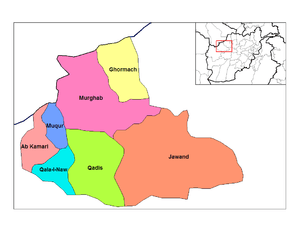
Districts
Badghis province is divided into seven districts.[15]
- Ab Kamari
- Ghormach District officially administrated by Faryab
- Jawand District
- Muqur District
- Murghab District (Bala Murghab)
- Qadis District
- Qala i Naw District
See also
Notes and references
- 1 2 3 "Project Development Plan: Badghis Provincial Profile" (PDF). =Afghanistan Ministry of Rural Rehabilitation and Development. Archived from the original (PDF) on 2 December 2010.
- ↑ Bosworth, C. E.; Balland, D. "BAÚD¨GÚÈS". In Yarshater, Ehsan. Encyclopædia Iranica. United States: Columbia University. Archived from the original on 2 January 2009.
- ↑ Shroder, John F. (2016). "Hari Rud – Murghab River Basin". Transboundary Water Resources in Afghanistan: Climate Change and Land-Use Implications. Saint Louis: Elsevier. pp. 410–412. ISBN 978-0-12-801861-3.
- ↑ Wily, Liz Alden (2004). "Glossary". Looking for Peace on the Pastures: Rural Land Relations in Afghanistan (PDF). Kabul, Afghanistan: Afghanistan Research and Evaluation Unit. p. ii. Archived (PDF) from the original on 12 July 2018.
- ↑

- ↑ "Badkhiz-Karabil semi-desert (PA1306)". National Geographic. Archived from the original on 8 March 2010.
- 1 2 3 "Badghis Provincial Overview". United States: Naval Postgraduate School. Archived from the original on 12 July 2018.
- 1 2 "Background profile of Badghis province". Pajhwok Afghan News. 2014. Archived from the original on 2 March 2014.
- 1 2 "Provincial profile for Badghis Province" (PDF). Regional Rural Economic Regeneration Strategies (RRERS). United States: Naval Postgraduate School. Archived (PDF) from the original on 12 July 2018.
- ↑ Sarwar, Mustafa (5 June 2018). "Almost Two-Thirds Of Afghanistan Hit By Drought". Gandhara.
- ↑ "Qala-i-Naw Airport". Islamic Republic of Afghanistan Ministry of Transport and Civil Aviation. Archived from the original on 27 September 2007.
- ↑ "Ring Road Construction Restarts After Five Years". Tolo News. 27 August 2012. Archived from the original on 30 September 2013.
- 1 2 "Badghis Province". Civil-Military Fusion Centre. Archived from the original on 31 May 2014.
- 1 2 "Badghis Province In A Glance" (PDF). Afghanistan Provincial Health Profile: Situational Analysis of Provincial Health Services. MoPH HMIS Department. p. 3. Archived (PDF) from the original on 12 July 2018.
- ↑ "Province of Badghis: A Socio-Economic and Demographic Profile" (PDF). UNFPA. 2003. Archived (PDF) from the original on 12 July 2018.
External links
- Map of Badghis Province (PDF)
- Badghis Province Overview - Slides (University of Montana)
- Afghanistan Information Management Service
Places adjacent to Badghis Province | ||||||||||
|---|---|---|---|---|---|---|---|---|---|---|
| ||||||||||