Arakht
| Arakht | |
|---|---|
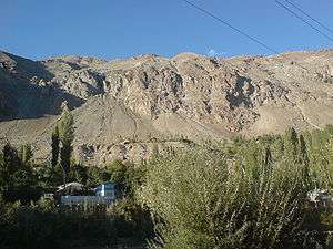 Typical scenery of the area | |
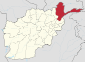
 Arakht Location in Afghanistan | |
| Coordinates: 37°22′0″N 71°25′0″E / 37.36667°N 71.41667°ECoordinates: 37°22′0″N 71°25′0″E / 37.36667°N 71.41667°E | |
| Country |
|
| Province | Badakhshan Province |
| Elevation | 3,100 m (10,200 ft) |
| Time zone | + 4.30 |
Arakht is a village in Badakhshan Province in north-eastern Afghanistan.[1]
It is located between Lake Shiva and the Panj River,[2] at an elevation of 3,100 metres (10,200 ft) near the Tajikistan border. It lies 5.3 kilometres (3.3 mi) from Pish, 4.2 km (2.6 mi) from Wishtayn, 6.1 km (3.8 mi) from Gordzhak and 10.0 km (6.2 mi) from Ghar Javin.
The nearest airport is 14 km (9 mi) away across the border at Khorog.
See also
References
- ↑ "NGA GeoNames Database". National Geospatial-Intelligence Agency. Retrieved 2008-05-27.
- ↑ Adamec, Ludwig W., ed. (1972). Historical and Political Gazetteer of Afghanistan. 1. Graz, Austria: Akadamische Druck-u. Verlangsanstalt. p. 23.
External links
This article is issued from
Wikipedia.
The text is licensed under Creative Commons - Attribution - Sharealike.
Additional terms may apply for the media files.