Arthez-d'Armagnac
| Arthez-d'Armagnac | |
|---|---|
| Commune | |
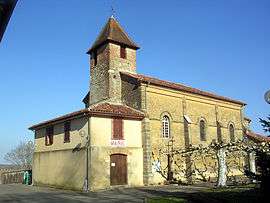 Church and town hall | |
 Arthez-d'Armagnac Location within Nouvelle-Aquitaine region  Arthez-d'Armagnac | |
| Coordinates: 43°53′45″N 0°15′29″W / 43.8958°N 0.2581°WCoordinates: 43°53′45″N 0°15′29″W / 43.8958°N 0.2581°W | |
| Country | France |
| Region | Nouvelle-Aquitaine |
| Department | Landes |
| Arrondissement | Mont-de-Marsan |
| Canton | Adour Armagnac |
| Intercommunality | CC Pays Villeneuve Armagnac Landais |
| Government | |
| • Mayor (2014-2020) | Michel Tartas |
| Area1 | 11.17 km2 (4.31 sq mi) |
| Population (2015)2 | 111 |
| • Density | 9.9/km2 (26/sq mi) |
| Time zone | UTC+1 (CET) |
| • Summer (DST) | UTC+2 (CEST) |
| INSEE/Postal code | 40013 /40190 |
| Elevation |
52–114 m (171–374 ft) (avg. 94 m or 308 ft) |
|
1 French Land Register data, which excludes lakes, ponds, glaciers > 1 km2 (0.386 sq mi or 247 acres) and river estuaries. 2 Population without double counting: residents of multiple communes (e.g., students and military personnel) only counted once. | |
Arthez-d'Armagnac (Occitan: Artés d'Armanhac) is a commune of the Landes department in Nouvelle-Aquitaine in southwestern France.
Population
| Historical population | ||
|---|---|---|
| Year | Pop. | ±% |
| 1962 | 169 | — |
| 1968 | 205 | +21.3% |
| 1975 | 179 | −12.7% |
| 1982 | 142 | −20.7% |
| 1990 | 93 | −34.5% |
| 1999 | 102 | +9.7% |
| 2006 | 125 | +22.5% |
| 2009 | 125 | +0.0% |
| 2015 | 111 | −11.2% |
See also
References
| Wikimedia Commons has media related to Arthez-d'Armagnac. |
This article is issued from
Wikipedia.
The text is licensed under Creative Commons - Attribution - Sharealike.
Additional terms may apply for the media files.