Tromøy
| Tromøy kommune | ||
|---|---|---|
| Former Municipality | ||
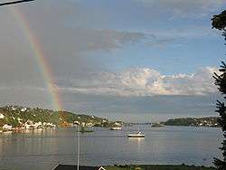 View of Tromøy | ||
| ||
| Nickname(s): The pearl of Southern Norway | ||
 Tromøy kommune Location of the municipality  Tromøy kommune Tromøy kommune (Norway) | ||
| Coordinates: 58°26′59″N 08°51′51″E / 58.44972°N 8.86417°ECoordinates: 58°26′59″N 08°51′51″E / 58.44972°N 8.86417°E | ||
| Country | Norway | |
| Region | Southern Norway | |
| County | Aust-Agder | |
| District | Østre Agder | |
| Municipality ID | NO-0921 | |
| Adm. Center | Brekka | |
| Area[1] | ||
| • Total | 30 km2 (10 sq mi) | |
| Time zone | UTC+01:00 (CET) | |
| • Summer (DST) | UTC+02:00 (CEST) | |
| Created from | Østre Moland in 1878 | |
| Merged into | Arendal in 1992 | |
Tromøy (historic: Tromø) is a former municipality in Aust-Agder county, Norway. The 30-square-kilometre (12 sq mi) municipality existed from 1878 until its dissolution in 1992. The municipal area is now part of the municipality of Arendal. The administrative centre was the village of Brekka where the historic Tromøy Church is located. The municipality encompassed all of the island of Tromøya as well as many smaller surrounding islands such as Merdø, Gjesøya, Skilsøy, and Tromlingene.[1]
The municipality had two churches: the centuries-old Tromøy Church and the relatively-new Færvik Church. Some of the main villages in Tromøy were Færvik, Brekka, Brattekleiv, Sandnes, Revesand, and Pusnes. The municipality was connected to the mainland by the Tromøy Bridge, the only road connection to Tromøya. The other islands in Tromøy were only accessible by boat.
History
The municipality of Tromøy was established on 1 May 1878 when the municipality of Østre Moland was divided into three separate municipalities: Tromøy (population: 2,320), Barbu (population: 4,874), and Østre Moland (population: 2,524). On 1 January 1992, there was a major municipal merger where the following municipalities were merged into one large municipality of Arendal: Tromøy (population: 4,711), Moland (population: 8,148), Øyestad (population: 8,679), Hisøy (population: 4,026), and the town of Arendal (population: 12,478).[2]
Name
The municipality (originally the parish) was named after the island on which it is located, Tromøya. Historically, it was spelled Tromø, but more recently it has been spelled Tromøy. The name comes from the Old Norse word Þruma which means "rim", "edge", or "border". The suffix -ø or øy mean "island".[3]
Coat-of-arms
The coat-of-arms is from modern times; they were granted on 23 August 1985. The blue and white arms represent the sea and the coastline near the village of Brekka, which is characterised by large rounded boulders protruding out into the sea. This landscape dates back to the ice age and it was used to model the division line in the coat-of-arms.[4]
Media gallery
 Coat-of-arms of Tromøy municipality
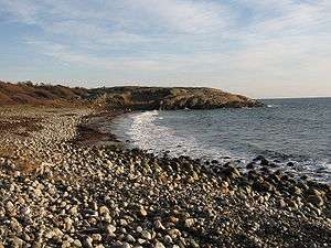 Spornes headland on Tromøya
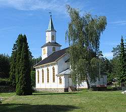
 Lighthouse
 Hove Forest
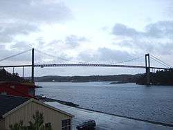 Tromøy bridge
References
- 1 2 Thorsnæs, Geir, ed. (2015-06-24). "Tromøy – kommune". Store norske leksikon (in Norwegian). Kunnskapsforlaget. Retrieved 2017-11-26.
- ↑ Jukvam, Dag (1999). "Historisk oversikt over endringer i kommune- og fylkesinndelingen" (PDF) (in Norwegian). Statistisk sentralbyrå.
- ↑ Rygh, Oluf (1905). Norske gaardnavne: Nedenes amt (in Norwegian) (8 ed.). Kristiania, Norge: W. C. Fabritius & sønners bogtrikkeri. p. 97.
- ↑ "Civic heraldry of Norway - Norske Kommunevåpen". Heraldry of the World. Retrieved 2017-11-26.
External links
| Wikimedia Commons has media related to Tromøy. |
