Bykle
| Bykle kommune | |||
|---|---|---|---|
| Municipality | |||
| |||
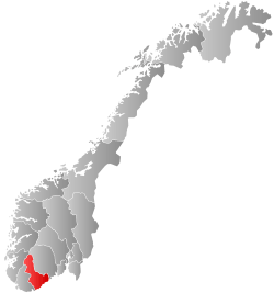
 Bykle within Aust-Agder | |||
| Coordinates: 59°26′35″N 07°15′18″E / 59.44306°N 7.25500°ECoordinates: 59°26′35″N 07°15′18″E / 59.44306°N 7.25500°E | |||
| Country | Norway | ||
| County | Aust-Agder | ||
| District | Setesdal | ||
| Administrative centre | Bykle | ||
| Government | |||
| • Mayor (2011) | Jon-Rolf Næss (Ap) | ||
| Area | |||
| • Total | 1,467.13 km2 (566.46 sq mi) | ||
| • Land | 1,253.94 km2 (484.15 sq mi) | ||
| • Water | 213.19 km2 (82.31 sq mi) | ||
| Area rank | #55 in Norway | ||
| Population (2017) | |||
| • Total | 952 | ||
| • Rank | #400 in Norway | ||
| • Density | 0.8/km2 (2/sq mi) | ||
| • Change (10 years) | 5.5% | ||
| Demonym(s) |
Byklar (N) Bykler (B)[1] | ||
| Time zone | UTC+01:00 (CET) | ||
| • Summer (DST) | UTC+02:00 (CEST) | ||
| ISO 3166 code | NO-0941 | ||
| Official language form | Nynorsk | ||
| Website |
www | ||

Bykle is a municipality in Aust-Agder county, Norway. It is located in the traditional district of Setesdal. The administrative centre of the municipality is the village of Bykle. Other villages in Bykle municipality include Berdalen, Bjåen, Breive, Hoslemo, Hovden, and Nordbygdi. Bykle was established as a municipality on 1 January 1902 when it was separated from the municipality of Valle.
The 1,467-square-kilometre (566 sq mi) municipality is the 55th largest by area out of the 422 municipalities in Norway. Bykle is the 400th most populous municipality in Norway with a population of 952. The municipality's population density is 0.8 inhabitants per square kilometre (2.1/sq mi) and its population has increased by 5.5% over the last decade.[2]
General information

The municipality of Bykle was created when it was separated from the older municipality of Valle on 1 January 1902 after a dispute over the costs of road building (Bykle was the bigger area, while Valle had more people and more money).[3] Initially, Bykle had a population of 476 residents in the new municipality. The boundaries of the municipality have not changed since that time.[4]
Name
The municipality (originally the parish) is named after the old Byklum farm (Old Norse: Byklar), since the first Bykle Church was built there. The farm is named after Lake Bykil, but the meaning of that name is unknown. Historically, the name has been spelled Bøgle or Bøckle, but the spelling has been Bykle since the 19th century.[5]
Coat-of-arms
The coat-of-arms is from modern times; they were granted on 4 April 1986. The arms show eleven (11) silver or white water droplets on a green background. The water droplets were chosen as a symbol for the water and rivers in the municipality, as well as for the hydropower plant which was founded in 1915. The plant has brought prosperity to the area since then. The green color of the background symbolizes agriculture.[6]
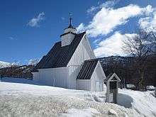
Churches
The Church of Norway has one parish (sokn) within the municipality of Bykle. It is part of the Otredal prosti (deanery) in the Diocese of Agder og Telemark.
| Parish (Sokn) | Church Name | Location of the Church | Year Built |
|---|---|---|---|
| Bykle | Bykle Church | Bykle | 2004 |
| Old Bykle Church | Bykle | 1619 | |
| Fjellgardane Church | Hovden | 1955 |
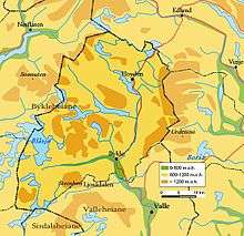
Geography
Bykle sits in the northern part of the Setesdalen valley. It is bordered to the north by Vinje municipality and to the east by Tokke municipality both of which are in Telemark county. It is bordered to the south by Valle in Aust-Agder county and by Sirdal municipality in Vest-Agder county. It is bordered in the southwest by Forsand municipality and in the west by Hjelmeland and Suldal municipalities–all in Rogaland county.
There are many lakes that are located within the mountainous municipality including Blåsjø, Botsvatn, Hartevatnet, Holmavatnet, Ormsavatnet, Reinevatn, Skyvatn, Store Urevatn, Svartevatnet, and Vatndalsvatnet, and Ytre Storevatnet.
The Setesdalsheiene mountain range runs through the municipality, including the tallest mountain in that range, Sæbyggjenuten at 1,507 metres (4,944 ft). The Byklestigen pass is a torturous trail up a steep cliff face. Until the 1870s, it was the only route to reach Bykle from the middle Setesdal valley to the south. It runs above the river Otra and was the site of numerous accidents on the hazardous route. The eastern side of the valley (and the municipal/county border) is lined by the mountains Gråsteinsnosi, Brandsnutene, Svolhusgreini, Sæbyggjenuten, and Støylsdalsnutene. The western side of the valley (and the municipal/county border) is lined by the mountains Storhellernuten, Skyvassnuten, Sveigen, and Kaldafjellet. The southern border of the municipality is marked by the mountain Steinheii. The mountains Urevassnutene, Djuptjønnuten, Snjoheinuten, and Kvervetjønnuten mark the highlands in the southwestern part of the municipality, northwest of the village of Bykle.
Climate
| Climate data for Bykle | |||||||||||||
|---|---|---|---|---|---|---|---|---|---|---|---|---|---|
| Month | Jan | Feb | Mar | Apr | May | Jun | Jul | Aug | Sep | Oct | Nov | Dec | Year |
| Daily mean °C (°F) | −6.1 (21) |
−5.7 (21.7) |
−1.3 (29.7) |
2.5 (36.5) |
8.0 (46.4) |
13.1 (55.6) |
14.1 (57.4) |
13.0 (55.4) |
9.0 (48.2) |
4.7 (40.5) |
−1.6 (29.1) |
−4.1 (24.6) |
3.8 (38.8) |
| Average precipitation mm (inches) | 79 (3.11) |
55 (2.17) |
54 (2.13) |
37 (1.46) |
70 (2.76) |
73 (2.87) |
72 (2.83) |
97 (3.82) |
117 (4.61) |
127 (5) |
109 (4.29) |
69 (2.72) |
80 (3.15) |
| Source: Norwegian Meteorological Institute[7] | |||||||||||||
Economy
Bykle has several hydroelectric power generation facilities. The second-largest sector of income for Bykle is the alpine skiing facility in Hovden. Due to its vast amount of hydroelectric power, Bykle is now the wealthiest of the municipalities in Setesdal.
Government
All municipalities in Norway, including Bykle, are responsible for primary education (through 10th grade), outpatient health services, senior citizen services, unemployment and other social services, zoning, economic development, and municipal roads. The municipality is governed by a municipal council of elected representatives, which in turn elect a mayor.
Municipal council
The municipal council (Kommunestyre) of Bykle is made up of 13 representatives that are elected to four year terms. Currently, the party breakdown is as follows:[8]
| Party Name | Name in Norwegian | Number of representatives | |
|---|---|---|---|
| Labour Party | Arbeiderpartiet | 6 | |
| Conservative Party | Høgre | 2 | |
| Christian Democratic Party | Kristelig Folkeparti | 1 | |
| Centre Party | Senterpartiet | 2 | |
| Liberal Party | Venstre | 2 | |
| Total number of members: | 13 | ||
Politics
Bykle has been run by one mayor, Kai Jeiskelid, from 1985 until 2011. In September 2011, a new mayor was elected: Jon-Rolf Næss. Due to a law implemented for 50 years ago by the Labour Party, the obligation of politicians' residence in this municipality is required.
History
At Storhedder, north of the lake Storheddervatnet near the mountain Storheddernuten, there are prehistoric runic inscriptions dating over 1000 years old.
The Hovden area was interconnected more with the districts to the west of the mountains than communities further down the Setesdal valley. The main mountain plateau trade route led west to Suldal municipality in Rogaland. The Byklestigen pass was the line of divisions between dialects; in Valle to the south the classic Setesdal tongue was spoken while in Bykle the dialect includes a significant mixture from neighboring Telemark county.
Falcons were trapped in the heights above Bykle. From as early as 1203 and as late as 1780 there are reports of English and Dutch trapping of falcons at Breivik in Bykle. One byproduct of the numerous Dutch visits in the 1560s was the discovery that the natives had no natural resistance to syphilis; a state physician had to be dispatched there to stem the disease.
.jpg) Farm - c. 1885
Farm - c. 1885.jpg) Farm - c. 1885
Farm - c. 1885.jpg) Traveling in Bykle - c. 1885
Traveling in Bykle - c. 1885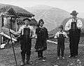 Farming family from Bykle wearing traditional bunads - c. 1885
 Farming family from Bykle wearing traditional bunads - c. 1885
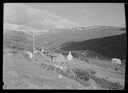 View of the village of Bykle and the Old Bykle Church - 1948
Attractions
- Old Bykle Church, built in 1619, is found in the village of Bykle. It stands on the site of an older stave church
- Open air museums at Huldreheimen and Lislestog.
- Hovden ski resort and village is found in the north along Norwegian National Road 9.
- Viking Age bog iron museum, which recognizes the industry in the area over 1000 years ago, located at Hovden
- Prehistoric runic inscriptions at Storhedder
References
- ↑ "Navn på steder og personer: Innbyggjarnamn" (in Norwegian). Språkrådet. Retrieved 2015-12-01.
- ↑ Statistisk sentralbyrå (2017). "Table: 06913: Population 1 January and population changes during the calendar year (M)" (in Norwegian). Retrieved 2017-11-05.
- ↑ Stagg, Frank Noel (1958). South Norway. George Allen & Unwin, Ltd.
- ↑ Jukvam, Dag (1999). "Historisk oversikt over endringer i kommune- og fylkesinndelingen" (PDF) (in Norwegian). Statistisk sentralbyrå.
- ↑ Rygh, Oluf (1905). Norske gaardnavne: Nedenes amt (in Norwegian) (8 ed.). Kristiania, Norge: W. C. Fabritius & sønners bogtrikkeri. pp. 211–213.
- ↑ "Civic heraldry of Norway - Norske Kommunevåpen". Heraldry of the World. Retrieved 2017-03-20.
- ↑ "Weather statistics for Bykle (Aust-Agder)". Norwegian Meteorological Institute.
- ↑ "Table: 04813: Members of the local councils, by party/electoral list at the Municipal Council election (M)" (in Norwegian). Statistics Norway. 2015.
External links
| Wikimedia Commons has media related to Bykle. |
| Look up Bykle in Wiktionary, the free dictionary. |
| Wikivoyage has a travel guide for Aust-Agder. |
- Municipal fact sheet from Statistics Norway (in Norwegian)
- Visiting Bykle and Hovden (in English)
- Municipal website (in Norwegian)