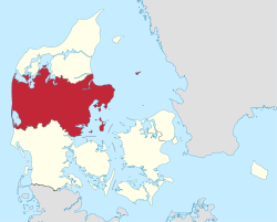
Central Denmark Region
| Central Denmark Region Region Midtjylland | |||
|---|---|---|---|
| Region of Denmark | |||
| |||
 | |||
| Country | Denmark | ||
| Largest city | Aarhus | ||
| Capital | Viborg | ||
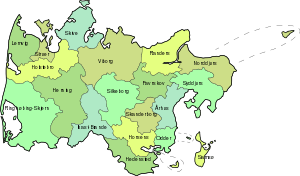
| Municipalities | |||
| Government | |||
| • Chairman | Anders Kühnau (Social Democrats) | ||
| Area | |||
| • Total | 13,053 km2 (5,040 sq mi) | ||
| Population (January 2018)[1] | |||
| • Total | 1,313,596 | ||
| • Density | 100/km2 (260/sq mi) | ||
| Time zone | UTC+1 (CET) | ||
| • Summer (DST) | UTC+2 (CEST) | ||
| Website | www.rm.dk | ||

Central Denmark Region (Danish: Region Midtjylland), commonly referred to as Central Jutland Region[2] and sometimes simply Mid Jutland,[3][4][5][6] is an administrative region of Denmark established on 1 January 2007 as part of the 2007 Danish Municipal Reform. The reform abolished the traditional counties (amter) and replaced them with five new administrative regions. At the same time, smaller municipalities were merged into larger units, cutting the total number of municipalities from 271 to 98. Central Denmark Region comprises 19 municipalities.
Toponymy
The Danish name of the region stresses the contrast to Northern Jutland and Southern Jutland (which together with Funen and some smaller islands forms the Region of Southern Denmark). For communication in English, the regional administration has decided to use another term, which is no correct translation of the Danish name. The autorities, in English, call their region "Central Denmark", supposing that the name Jutland might be too unknown in the English speaking public.
Geography
Central Denmark Region comprise the geographical regions of Østjylland (East Jutland), Kronjylland (Crown Jutland), Midtjylland (Central Jutland), and parts of Vestjylland (West Jutland) along the North Sea coast. Important geographical areas within these larger designations include Søhøjlandet, the peninsulas of Djursland and Salling, and the central parts of the Jutland Ridge.
The western parts of the region are characterised by coastal dunes and inland heaths while the slightly elevated central parts and the relatively hilly eastern parts are characterised by forests, lakes and streams, with plenty of fertile soils. The eastern parts (Østjylland) are the most densely populated area within the region and form a large part of the East Jutland metropolitan area with a population of about 1.4 million.
Administratively, Central Denmark Region consists of the former counties of Ringkjøbing and Århus (except the western half of Mariager municipality which joined Region Nordjylland), most of the former county of Viborg, and the northern half of Vejle County. The areas in question from the two latter counties were the former municipalities of Bjerringbro, Fjends, Hvorslev, Karup, Kjellerup, Møldrup, Sallingsund, Skive, Spøttrup, Sundsøre, Tjele, and Viborg from Viborg County and Brædstrup, Gedved, Hedensted, Horsens, Juelsminde, Nørre-Snede and Tørring-Uldum from Vejle County.
The neighbouring administrative region to the south is called Southern Denmark (Danish: Region Syddanmark), as it includes not only the southern parts of Jutland, but also the island of Funen and smaller neighbouring islands. Furthermore, Sønderjylland (Southern-Jutland), is the traditional name for the Danish part of the former Duchy of Schleswig.
Geologically the region lies in the northern part of Denmark which is rising because of post-glacial rebound.
See also
References
- ↑ FOLK1: Population 1 October database from Statistics Denmark
- ↑ Danish state authorities use both the Danish name Midtjylland and the direct translation Central Jutland in English texts. Central Jutland Region or Region of Central Jutland are also widely used by others (e.g. the city of Århus Archived January 24, 2010, at the Wayback Machine.), but the Region itself prefers 'Central Denmark'.
- ↑ Visit Denmark – Share Mid Jutland
- ↑ Cyclistic – Mid Jutland
- ↑ [cphpost.dk/news/archaeologists-uncover-medieval-village-in-mid-jutland.html Archaeologists uncover medieval village in mid-Jutland – The Post]
- ↑ OECD – Entrepreneurship Review of Denmark - Page 99
External links
- Official website (in English)
- Central Denmark Office to the EU (in English)

| Municipalities | | |
|---|---|---|
| Cities and towns | ||
| Geographic features | ||
| ||
| Overseas constituent countries | |||||
|---|---|---|---|---|---|
.svg.png)