Vegårshei
| Vegårshei kommune | |||
|---|---|---|---|
| Municipality | |||
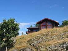
 View of the lake Vegår | |||
| |||
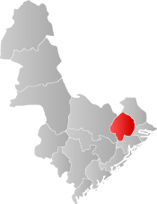 Vegårshei within Aust-Agder | |||
| Coordinates: 58°46′32″N 08°49′56″E / 58.77556°N 8.83222°ECoordinates: 58°46′32″N 08°49′56″E / 58.77556°N 8.83222°E | |||
| Country | Norway | ||
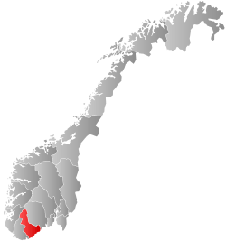
| County | Aust-Agder | ||
| District | Sørlandet | ||
| Administrative centre | Myra | ||
| Government | |||
| • Mayor (2015) | Kirsten Helen Myren (Sp) | ||
| Area | |||
| • Total | 355.65 km2 (137.32 sq mi) | ||
| • Land | 321.78 km2 (124.24 sq mi) | ||
| • Water | 33.87 km2 (13.08 sq mi) | ||
| Area rank | #256 in Norway | ||
| Population (2017) | |||
| • Total | 2,104 | ||
| • Rank | #321 in Norway | ||
| • Density | 6.5/km2 (17/sq mi) | ||
| • Change (10 years) | 12.9% | ||
| Demonym(s) | Vegårsheiing[1] | ||
| Time zone | UTC+01:00 (CET) | ||
| • Summer (DST) | UTC+02:00 (CEST) | ||
| ISO 3166 code | NO-0912 | ||
| Official language form | Neutral | ||
| Website |
www | ||
Vegårshei is a municipality in Aust-Agder county, Norway. It is located in the traditional district of Sørlandet. The administrative center is the village of Myra. Other villages in Vegårshei include Mo and Ubergsmoen.[2]
The 356-square-kilometre (137 sq mi) municipality is the 256th largest by area out of the 422 municipalities in Norway. Vegårshei is the 321st most populous municipality in Norway with a population of 2,104. The municipality's population density is 6.5 inhabitants per square kilometre (17/sq mi) and its population has increased by 12.9% over the last decade.[3]
General information


The parish of Vegaardsheien was established as a municipality on 1 January 1838 (see formannskapsdistrikt). The borders of the municipality have not changed since that time.[4]
Name
The Old Norse form of the name may have been Vigisheiðr. The first element is the genitive case of the name of the lake Vegår (of which the Old Norse form and the meaning of the name is uncertain). The last element is heiðr which means "heath" or "moor".[2][5] Historically, the name was spelled as Wegaardsheien or Vegaardsheien, and sometimes it was abbreviated as simply Heien.
Coat-of-arms
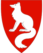
The coat-of-arms is from modern times. They were granted on 30 April 1987. The arms show a fox as a representative of the local wildlife and also for the fox farming in the village.[6]
Churches
The Church of Norway has one parish (sokn) within the municipality of Vegårshei. It is part of the Aust-Nedenes prosti (deanery) in the Diocese of Agder og Telemark.
| Parish (Sokn) | Church Name | Location of the Church | Year Built |
|---|---|---|---|
| Vegårshei | Vegårshei Church | Myra | 1808 |
Geography
Vegårshei is bordered on the north by the municipalities of Nissedal (in Telemark county) and Gjerstad, on the east by Risør, on the south by Tvedestrand, and on the west by Åmli. The lake Vegår dominates the northern part of the hilly and forested municipality.
Government
All municipalities in Norway, including Vegårshei, are responsible for primary education (through 10th grade), outpatient health services, senior citizen services, unemployment and other social services, zoning, economic development, and municipal roads. The municipality is governed by a municipal council of elected representatives, which in turn elect a mayor.
Municipal council
The municipal council (Kommunestyre) of Vegårshei is made up of 21 representatives that are elected to four year terms. Currently, the party breakdown is as follows:[7]
| Party Name | Name in Norwegian | Number of representatives | |
|---|---|---|---|
| Labour Party | Arbeiderpartiet | 6 | |
| Progress Party | Fremskrittspartiet | 1 | |
| Conservative Party | Høyre | 3 | |
| Christian Democratic Party | Kristelig Folkeparti | 6 | |
| Centre Party | Senterpartiet | 5 | |
| Total number of members: | 21 | ||
Economy
Vegårshei used to be primarily an agricultural and lumber-based community. It is well-suited for hunting and fishing for residents and tourists alike.
Transportation
The Sørlandsbanen railway line runs through the municipality, stopping at Vegårshei Station, just north of the village of Myra. There are several Norwegian county roads that cross the municipality, connecting it to its neighbors. Some of the roads include Norwegian County Road 414, Norwegian County Road 415, Norwegian County Road 416, and Norwegian County Road 417.
References
- ↑ "Navn på steder og personer: Innbyggjarnamn" (in Norwegian). Språkrådet. Retrieved 2015-12-01.
- 1 2 Thorsnæs, Geir, ed. (2016-04-05). "Vegårshei". Store norske leksikon (in Norwegian). Kunnskapsforlaget. Retrieved 2017-12-26.
- ↑ Statistisk sentralbyrå (2017). "Table: 06913: Population 1 January and population changes during the calendar year (M)" (in Norwegian). Retrieved 2017-12-26.
- ↑ Jukvam, Dag (1999). "Historisk oversikt over endringer i kommune- og fylkesinndelingen" (PDF) (in Norwegian). Statistisk sentralbyrå.
- ↑ Rygh, Oluf (1905). Norske gaardnavne: Nedenes amt (in Norwegian) (8 ed.). Kristiania, Norge: W. C. Fabritius & sønners bogtrikkeri. p. 1.
- ↑ "Civic heraldry of Norway - Norske Kommunevåpen". Heraldry of the World. Retrieved 2017-12-26.
- ↑ "Table: 04813: Members of the local councils, by party/electoral list at the Municipal Council election (M)" (in Norwegian). Statistics Norway. 2015.
External links

- Municipal fact sheet from Statistics Norway (in Norwegian)

| Authority control |
|---|