Gjerstad
| Gjerstad kommune | |||
|---|---|---|---|
| Municipality | |||
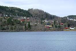 View of Gjerstad from the Gjerstadvatnet | |||
| |||
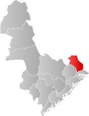 Gjerstad within Aust-Agder | |||
| Coordinates: 58°53′33″N 08°57′24″E / 58.89250°N 8.95667°ECoordinates: 58°53′33″N 08°57′24″E / 58.89250°N 8.95667°E | |||
| Country | Norway | ||
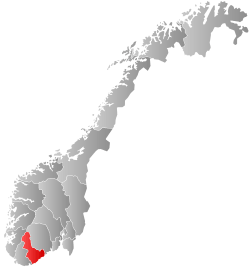
| County | Aust-Agder | ||
| District | Østre Agder | ||
| Administrative centre | Gjerstad | ||
| Government | |||
| • Mayor (2015) | Inger Løite (Ap) | ||
| Area | |||
| • Total | 322.14 km2 (124.38 sq mi) | ||
| • Land | 307.65 km2 (118.78 sq mi) | ||
| • Water | 14.49 km2 (5.59 sq mi) | ||
| Area rank | #264 in Norway | ||
| Population (2017) | |||
| • Total | 2,511 | ||
| • Rank | #295 in Norway | ||
| • Density | 8.2/km2 (21/sq mi) | ||
| • Change (10 years) | -0.1% | ||
| Demonym(s) |
Gjersdøl Gjersdøling[1] | ||
| Time zone | UTC+01:00 (CET) | ||
| • Summer (DST) | UTC+02:00 (CEST) | ||
| ISO 3166 code | NO-0911 | ||
| Official language form | Neutral | ||
| Website |
www | ||
Gjerstad is a municipality in Aust-Agder county, Norway. It is located in the traditional region of Sørlandet, in the southeastern part of the county, along the border with Telemark county.[2] The administrative centre of the municipality is the village of Gjerstad. Other villages in the municipality include Ausland, Eikeland, Fiane, Gryting, Østerholt, Rød, Sundebru, and Vestøl.
The 322-square-kilometre (124 sq mi) municipality is the 264th largest by area out of the 422 municipalities in Norway. Gjerstad is the 295th most populous municipality in Norway with a population of 2,511. The municipality's population density is 8.2 inhabitants per square kilometre (21/sq mi) and its population has decreased by 0.1% over the last decade.[3]
General information
The parish of Gjerstad was established as a municipality on 1 January 1838 (see formannskapsdistrikt). The borders have not changed since that time.[4]
Name
The municipality (originally the parish) is named after the old Gjerstad farm (Old Norse: Geirreksstaðir), since the Gjerstad Church was built there. One explanation of the name says that the first element is the genitive case of the male name Geirrekr and the last element is staðir which means "homestead" or "farm".[5][6] Another possibly explanation of the first part of the name says that it comes from the word geirr which means "spear". Historically, the name has been spelled Gerikstadum (c. 1400), Gierestat (c. 1567), Gierrestad, and Gjerrestad.
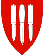
Coat-of-arms
The coat-of-arms is from modern times; they were granted on 18 April 1986. The arms show three white or silver knives on a red background. The knife was chosen as a symbol for the smithies and knife makers in the municipality. Knife making has long been a local tradition for which the village is well known.[7]
Churches
The Church of Norway has one parish (sokn) within the municipality of Gjerstad. It is part of the Aust-Nedenes prosti (deanery) in the Diocese of Agder og Telemark.
| Parish (Sokn) | Church Name | Location of the Church | Year Built |
|---|---|---|---|
| Gjerstad | Gjerstad Church | Gjerstad | 1848 |
History
Until about 1650, the prestegjeld of Gjerstad (the precursor to today's municipality) was named Vissedal (from vidr-ser-dalr meaning "wood-sea-dale"), a very proper description of the area. Gjerstad has been inhabited from the Stone Age and Viking Age through modern times. Agriculture has long been important, and until only decades ago the more marginal outfields in Upper Gjerstad were still utilized. Forestry also provided an important historic economic contribution, and logs were driven on rivers and streams in the municipality. To aid log transport by floating, numerous dams were constructed. Eikeland Ironworks were a significant contribution to the economy as well.
Geography
Gjerstad municipality has numerous glacially formed features, including a U-shaped valley, tarns, and lakes, most notably the large lake Gjerstadvatnet. It located in Aust-Agder county and it is bordered to the north by Nissedal and Drangedal municipalities (both in Telemark county); to the east by Kragerø municipality (also in Telemark); to the south by Risør municipality; and to the southwest by Vegårshei municipality. There are several larger roads that traverse Gjerstad: European route E18, Norwegian County Road 417, and Norwegian County Road 418.
Government
All municipalities in Norway, including Gjerstad, are responsible for primary education (through 10th grade), outpatient health services, senior citizen services, unemployment and other social services, zoning, economic development, and municipal roads. The municipality is governed by a municipal council of elected representatives, which in turn elect a mayor.
Municipal council
The municipal council (Kommunestyre) of Gjerstad is made up of 17 representatives that are elected to four year terms. Currently, the party breakdown is as follows:[8]
| Party Name | Name in Norwegian | Number of representatives | |
|---|---|---|---|
| Labour Party | Arbeiderpartiet | 6 | |
| Progress Party | Fremskrittspartiet | 1 | |
| Conservative Party | Høyre | 4 | |
| Christian Democratic Party | Kristelig Folkeparti | 1 | |
| Centre Party | Senterpartiet | 5 | |
| Total number of members: | 17 | ||
Attractions
- The remains of Eikeland Ironworks can still be seen in the upper valley. Gjerstad was famous for its beautiful handmade knives and the coat-of-arms recognizes this heritage.
- Horga was a former pagan place of sacrifice which was destroyed by Olav Trygvason, during the introduction of Christianity to Gjerstad. It lies 300 metres (980 ft) from Holmen Gård.
- Holmen Gård in Gjerstad (Norwegian: Holmen Gård i Gjerstad) is the site of a former farm. It was a Norwegian national center for folk art and handicraft until it was sold into private ownership in 2013. The site has been awarded the St. Olaf's Rose (Olavsrosa), a hallmark for Norwegian Heritage which designates especially distinguished places.
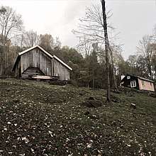
 Eikeland verk building
 Road with houses at the Eikeland verk in 1939
 View of the buildings at Holmen Gård, Photo: ©Torgrim Landsverk
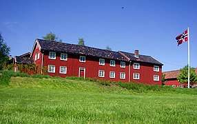 Main house at Holmen Gård, Photo: ©Torgrim Landsverk
Notable residents

- Niels Henrik Abel (1802–1829), a Norwegian mathematician who was the son of Søren Georg Abel. His grandfather, Hans Mathias Abel, served as the priest at Gjerstad Church from 1785 to 1804. His father, Søren, became the priest at Gjerstad in 1804, so Niels Abel spent his boyhood in the rectory at Gjerstad. Abel spent his last months at the nearby Frolands verk.
References
- ↑ "Navn på steder og personer: Innbyggjarnamn" (in Norwegian). Språkrådet. Retrieved 2015-12-01.
- ↑ "Gjerstad municipality". gonorway.com. Retrieved February 5, 2016.
- ↑ Statistisk sentralbyrå (2017). "Table: 06913: Population 1 January and population changes during the calendar year (M)" (in Norwegian). Retrieved 2017-12-29.
- ↑ Jukvam, Dag (1999). "Historisk oversikt over endringer i kommune- og fylkesinndelingen" (PDF) (in Norwegian). Statistisk sentralbyrå.
- ↑ Rygh, Oluf (1905). Norske gaardnavne: Nedenes amt (in Norwegian) (8 ed.). Kristiania, Norge: W. C. Fabritius & sønners bogtrikkeri. p. 11.
- ↑ Thorsnæs, Geir, ed. (2017-11-02). "Gjerstad". Store norske leksikon (in Norwegian). Kunnskapsforlaget. Retrieved 2017-12-28.
- ↑ "Civic heraldry of Norway - Norske Kommunevåpen". Heraldry of the World. Retrieved 2017-12-29.
- ↑ "Table: 04813: Members of the local councils, by party/electoral list at the Municipal Council election (M)" (in Norwegian). Statistics Norway. 2015.
External links
| Wikimedia Commons has media related to Gjerstad. |
| Look up Gjerstad in Wiktionary, the free dictionary. |
- Municipal fact sheet from Statistics Norway (in Norwegian)

- Welcome to Holmen Gård in Gjerstad
- Gjerstad.org (in Norwegian)
- Culture in Gjerstad on the map (in Norwegian)