Manila
Manila (/məˈnɪlə/; Tagalog: Maynilà, pronounced [majˈnilaʔ]), officially the City of Manila (Tagalog: Lungsod ng Maynilà [luŋˈsod nɐŋ majˈnilaʔ]), is the capital of the Philippines and a highly urbanized city. It is the most densely populated city proper in the world as of 2019.[11] It was the first chartered city by virtue of the Philippine Commission Act 183 on July 31, 1901 and gained autonomy with the passage of Republic Act No. 409 or the "Revised Charter of the City of Manila" on June 18, 1949.[12] Manila, alongside Mexico City and Madrid are considered the world's original set of Global Cities due to Manila's commercial networks being the first to traverse the Pacific Ocean, thus connecting Asia with the Spanish Americas, marking the first time in world history when an uninterrupted chain of trade routes circled the planet.[13] Manila is also the second most natural disaster-afflicted capital city in the world next to Tokyo,[14] yet it is simultaneously among the most populous and fastest growing cities in Southeast Asia.[15]
Manila Maynilà | |
|---|---|
Capital and Highly Urbanized City | |
| Lungsod ng Maynilà (City of Manila) | |
     .jpg) Clockwise from top: Manila Bay skyline, Manila City Hall, Quiapo Church, Malacañan Palace, Rizal Monument, Fort Santiago | |
 Flag  Seal | |
| Nickname(s): Pearl of the Orient[1] | |
| Motto(s): Manila, God First | |
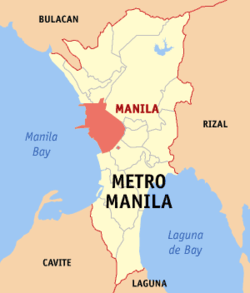 Map of Metro Manila with Manila highlighted | |
OpenStreetMap 
| |
.svg.png) Manila Location within the Philippines | |
| Coordinates: 14°35′45″N 120°58′38″E | |
| Country | |
| Region | National Capital Region (NCR) |
| Congressional District | 1st to 6th districts of Manila |
| Administrative District | 16 city districts |
| Currency | Philippine peso (₱) |
| Established | 13th century or earlier |
| Sultanate of Brunei (Rajahnate of Maynila) | 1500s |
| Spanish Manila | June 24, 1571 |
| City Charter | July 31, 1901 |
| Highly Urbanized City | December 22, 1979 |
| Barangays | 896 |
| Government | |
| • Type | Sangguniang Panlungsod |
| • Mayor | Francisco "Isko Moreno" Domagoso (NUP/Asenso Manileño) |
| • Vice Mayor | Dr. Ma. Sheilah "Honey Lacuna" Pangan (NUP/Asenso Manileño) |
| • City Representatives | List
|
| • City Council | Councilors
|
| • Electorate | 1,065,149 voters (2019) |
| Area | |
| • City | 42.88 km2 (16.56 sq mi) |
| • Urban | 1,474.82 km2 (569.43 sq mi) |
| • Metro | 619.57 km2 (239.22 sq mi) |
| Elevation | 5 m (16 ft) |
| Population | |
| • City | 1,780,148 |
| • Density | 41,515/km2 (107,520/sq mi) |
| • Urban | 22,710,000[7] |
| • Metro | 12,877,253 |
| • Metro density | 20,785/km2 (53,830/sq mi) |
| Demonym(s) | English: Manileño, Manilan; Spanish: manilense,[8] manileño(-a) Filipino: Manileño(-a), Manilenyo(-a), Taga-Maynila |
| Economy | |
| • Income class | special city income class |
| • Poverty incidence | 5.71% (2015)[9] |
| • HDI | 0.773[10] – high (2018) |
| • Revenue | ₱10,154,964,750.07 (2016) |
| • GDP | US $182.8 billion |
| Utilities | |
| • Electricity | MERALCO |
| • Water | • Maynilad (Majority) • Manila Water (Santa Ana and San Andres) |
| Time zone | UTC+8 (PST) |
| ZIP code | +900 – 1-096 |
| PSGC | |
| IDD : area code | +63 (0)2 |
| Climate type | tropical monsoon climate |
| Native languages | Tagalog |
| Website | manila |
The Spanish city of Manila was founded on June 24, 1571, by Spanish conquistador Miguel López de Legazpi. The date is regarded as the city's official founding date; however, a Tagalog fortified polity called Maynilà had already existed on the site, dating back as far as 1258, from which the Spanish and English name of 'Manila' was derived. A Spanish fortified city called Intramuros was built directly on top of the site of old Maynilà, following the defeat of the polity's last indigenous Rajah, Sulayman III, in the Battle of Bangkusay. Manila was the seat of power for most of the country's colonial rulers. It is home to many historic sites, some of which were built during the 16th century. Manila has many of the Philippines' firsts, including the first university (1590),[16] light station (1642), lighthouse tower (1846), water system (1878), hotel (1889), electricity (1895), oceanarium (1913),[17] stock exchange (1927), flyover (1930s), zoo (1959), pedestrian underpass (1960),[18] science high school (1963),[19] city-run university (1965), city-run hospital (1969), and rapid transit system (1984; also considered as the first rapid transit system in Southeast Asia).[20]
The term "Manila" is commonly used to refer to the whole metropolitan area, the greater metropolitan area or the city proper. The officially defined metropolitan area called Metro Manila, the capital region of the Philippines, includes the much larger Quezon City and the Makati Central Business District. It is the most populous region of the country, one of the most populous urban areas in the world,[21] and is one of the wealthiest regions in Southeast Asia.[22] The city proper is home to 1,780,148 people in 2015,[5] and is the historic core of a built-up area that extends well beyond its administrative limits. With 71,263 people per square kilometer, Manila is also the most densely populated city proper in the world.[5][6]
The city is located on the eastern shores of Manila Bay. The Pasig River flows through the middle of the city, dividing it into the north and south sections. Manila is made up of 16 administrative districts: Binondo, Ermita, Intramuros, Malate, Paco, Pandacan, Port Area, Quiapo, Sampaloc, San Andres, San Miguel, San Nicolas, Santa Ana, Santa Cruz, Santa Mesa and Tondo, while it is divided into six districts for its representation in Congress and the election of the city council members. In 2018, the Globalization and World Cities Research Network listed Manila as an "Alpha-" global city[23], in the same year, Manila is ranked seventh in economic performance globally and second regionally (the latter situation being behind Delhi, India)[24] while the Global Financial Centres Index ranks Manila 103rd in the world.[25]
Etymology
Maynilà, the Filipino name for the city, comes from the phrase may-nilà, which translates to "where indigo is found."[26] Nilà is derived from the Sanskrit word nīla (नील) which refers to indigo, and, by extension, to several plant species from which this natural dye can be extracted.[26][27] The Maynilà name is more likely in reference to the presence of indigo-yielding plants growing in the area surrounding the settlement, rather than Maynilà being known as a settlement that trades in indigo dye.[26] This is because the settlement was founded several hundred years before indigo dye extraction became an important economic activity in the area in the 18th century.[26] The native Tagalog name for the indigo plant, tayum (or variations thereof)[26][28] actually finds use in another toponym within the Manila area — Tayuman ("where the indigo [plant] is") — and elsewhere in the Philippines (e.g., Tayum, Abra; Tagum, Davao del Norte).
Maynilà was eventually adopted into Spanish as Manila.
May-nilad
An antiquarian and inaccurate etymology asserts the origin of the city's name as may-nilad ("where nilad is found").[26] Here, nilad is taken to be the name for one of two littoral plant species:
- popularly, but incorrectly: the water hyacinth (Eichhornia crassipes) which still grows on the banks of the Pasig River to this day.[26] However, it is a recent introduction to the Philippines from South America and therefore could not have been the plant species referred to in the toponym.[26]
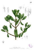
- correctly: a shrub-like tree (Scyphiphora hydrophyllacea, formerly Ixora manila Blanco) found in or near mangrove swamps,[26][29] This tree is the actual species that the Tagalog terms nilád or nilár refer to.[30]
From a linguistic perspective it is unlikely for native Tagalog speakers to completely drop the final consonant /d/ in nilad to arrive at the present form Maynilà.[26] As an example, nearby Bacoor still retains the final consonant of the old Tagalog word bakoód ("elevated piece of land"), even in old Spanish renderings of the placename (e.g., Vacol, Bacor).[31] Historians Ambeth Ocampo[32][33] and Joseph Baumgartner[26] have also found that in all early documents, the place had always been written without the final /d/, thereby making the may-nilad etymology spurious.
The misidentification of nilad as the source of the toponym appears to originate from an 1887 essay written by Trinidad Pardo de Tavera, in which he wrote nila as both referring to Indigofera tinctoria (true indigo) and to Ixora manila (actually, nilád in Tagalog[30]).[27][26] Early 20th century writings, such as those of Julio Nakpil[34] and of Blair and Robertson then repeated the claim.[35][33] Today, this erroneous etymology continues to be perpetuated through casual repetition in both literature[36][37] and popular use, such as in Maynilad Water Services and the name of the underpass close to Manila City Hall, Lagusnilad ("Nilad Pass").[32]
History
Early history
| Battles of Manila |
|---|
|
| See also |
|
| Around Manila |
|
The earliest evidence of human life around present-day Manila is the nearby Angono Petroglyphs, dated to around 3000 BC. Negritos, the aboriginal inhabitants of the Philippines, lived across the island of Luzon, where Manila is located, before the Malayo-Polynesians migrated in and assimilated them.[38]
Manila was an active trade partner with the Song and Yuan dynasties.[39] The polity of Tondo flourished during the latter half of the Ming dynasty as a result of direct trade relations with China. The Tondo district was the traditional capital of the empire, and its rulers were sovereign kings, not mere chieftains. Tondo was christened under the Chinese characters for "Eastern Totality (All)" or "東都" due to its location east of China. The kings of Tondo were addressed variously as panginuan in Maranao or panginoón in Tagalog ("lords"); anák banwa ("son of heaven"); or lakandula ("lord of the palace"). The Emperor of China considered the Lakans—the rulers of ancient Manila—"王", or kings.[40]
In the 13th century, Manila consisted of a fortified settlement and trading quarter on the shore of the Pasig River. It was then settled by the Indianized empire of Majapahit, as recorded in the epic eulogy poem "Nagarakretagama", which described the area's conquest by Maharaja Hayam Wuruk.[40] Selurong (षेलुरोङ्), a historical name for Manila, is listed in Canto 14 alongside Sulot, which is now Sulu, and Kalka. Selurong (Manila) together with Sulot (Sulu) was able to regain independence afterwards and Sulu even attacked and looted the Majapahit province of Po-ni (Brunei) in retribution.[40]
During the reign of the Arab Emir, Sharif Ali's descendant, Sultan Bolkiah, from 1485 to 1521, the Sultanate of Brunei which had seceded from Hindu Majapahit and became a Muslim, had invaded the area. The Bruneians wanted to take advantage of Tondo's strategic position in trade with China and Indonesia and thus attacked its environs and established the Muslim Rajahnate of Maynilà (كوتا سلودوڠ; Kota Seludong). The rajahnate was ruled under and gave yearly tribute to the Sultanate of Brunei as a satellite state.[41] It created a new dynasty under the local leader, who accepted Islam and became Rajah Salalila or Sulaiman I. He established a trading challenge to the already rich House of Lakan Dula in Tondo. Islam was further strengthened by the arrival of Muslim traders from the Middle East and Southeast Asia.[42]
Spanish period

On June 24, 1571, the conquistador Miguel López de Legazpi arrived in Manila and declared it a territory of New Spain (Mexico), establishing a city council in what is now the district of Intramuros. He took advantage of a Tondo vs Manila territorial conflict to justify expelling or converting Bruneian Muslim colonists who supported their Manila vassals while his Mexican grandson Juan de Salcedo had a romance with a princess of Tondo, Kandarapa.[43] López de Legazpi had the local royalty executed or exiled after the failure of the Conspiracy of the Maharlikas, a plot wherein an alliance between datus, rajahs, Japanese merchants and the Sultanate of Brunei would band together to execute the Spaniards, along with their Latin American recruits and Visayan allies. The victorious Spaniards made Manila, the capital of the Spanish East Indies and of the Philippines, which their empire would control for the next three centuries. In 1574, Manila was temporarily besieged by the Chinese pirate Lim Hong, who was ultimately thwarted by the local inhabitants. Upon Spanish settlement, Manila was immediately made, by papal decree, a suffragan of the Archdiocese of Mexico. Then, by royal decree of Philip II of Spain, the city of Manila was put under the spiritual patronage of Saint Pudentiana and Our Lady of Guidance (Spurred by a locally found sacred image i.e. a Black Madonna of unknown origin; one theory is that it is from Portuguese-Macau, another is that, it is a Tantric goddess and this was worshiped by the natives in a Pagan-Hindu manner and had survived Islamic iconoclasm by the Sultanate of Brunei. This image was interpreted to be of Marian nature, and it was found during the Miguel de Legazpi expedition and eventually a Mexican hermit built a chapel around that image).
Manila became famous for its role in the Manila–Acapulco galleon trade, which lasted for more than two centuries and brought goods from Europe, Africa and Hispanic America across the Pacific Islands to Southeast Asia (which was already an entrepôt for goods coming from India, Indonesia and China), and vice versa. Silver that was mined in Mexico and Peru was exchanged for Chinese silk, Indian gems and the spices of Indonesia and Malaysia. Likewise, wines and olives grown in Europe and North Africa were shipped via Mexico to Manila.[44] In 1606, upon the Spanish conquest of the Sultanate of Ternate, one of monopolizers of the growing of spice, the Spanish deported the Sultan of Ternate along with his clan and his entire entourage to Manila were they were initially enslaved and eventually converted to Christianity.[45] About 200 families of mixed Mexican-Filipino-Spanish and Papuan-Indonesian-Portuguese descent from Ternate and Tidor followed him there at a later date.[46] The city attained great wealth due to it being at the confluence of three great commercial exchanges: the Silk Road, the Spice Route and the Silver Flow. Jealous of her wealth, the city was captured by Great Britain in 1762 as part of the Seven Years' War in Europe.[47] The city was then occupied by the British for twenty months from 1762 to 1764 in their attempt to rule the Spanish East Indies, but the city was cut off from the rest of the country by Spanish-Filipino forces who refused to accept British rule.[48] Frustrated by their inability to take the rest of the archipelago, the British eventually withdrew in accordance with the 1763 Treaty of Paris. An unknown number of Indian soldiers known as sepoys, who came with the British, deserted and settled in nearby Cainta, Rizal, which explains the uniquely Indian features of generations of Cainta residents.[49][50]
The Chinese were then punished for supporting the British invasion, and the fortress city of Intramuros, initially populated by 1200 Spanish families and garrisoned by 400 Spanish troops,[51] kept its cannons pointed at Binondo, the world's oldest Chinatown.[52] The Mexican population was concentrated at the south part of Manila,[53][54] and also at Cavite, where ships from Spain's American colonies docked, and at Ermita, an area so named because of a Mexican hermit that lived there. The Philippines hosts the only Latin American-established districts in Asia.[55] When the Spanish evacuated Ternate, they settled the Papuan refugees in Ternate, Cavite which was named after their former homeland.[56]
The rise of Spanish Manila marked the first time in world history where all hemispheres and continents were interconnected in a worldwide trade network. Thus, making Manila, alongside Mexico and Madrid, the world's original set of Global Cities, predating the ascent of modern Alpha++ class world cities like New York or London as global financial centers, by hundreds of years.[57] A Spanish Jesuit Priest commented that due to the confluence of many foreign languages gathering in Manila, he said that the confessional in Manila is "the most difficult in the world."[58] Another Spanish missionary in the 1600s by the name of Fray Juan de Cobo was so astonished by the manifold commerce, cultural complexity and ethnic diversity in Manila he thus wrote the following to his brethren in Mexico:
"The diversity here is immense such that I could go on forever trying to differentiate lands and peoples. There are Castilians from all provinces. There are Portuguese and Italians; Dutch, Greeks and Canary Islanders, and Mexican Indians. There are slaves from Africa brought by the Spaniards [Through America], and others brought by the Portuguese [Through India]. There is an African Moor with his turban here. There are Javanese from Java, Japanese and Bengalese from Bengal. Among all these people are the Chinese whose numbers here are untold and who outnumber everyone else. From China there are peoples so different from each other, and from provinces as distant, as Italy is from Spain. Finally, of the mestizos, the mixed-race people here, I cannot even write because in Manila there is no limit to combinations of peoples with peoples. This is in the city where all the buzz is." (Remesal, 1629: 680–1)
— [59]
After Mexico gained independence in 1821, Spain began to govern Manila directly.[60] Under direct Spanish rule, banking, industry and education flourished more than they had in the previous two centuries.[61] The opening of the Suez Canal in 1869 facilitated direct trade and communications with Spain. The city's growing wealth and education attracted indigenous peoples, Negritos, Malays, Africans, Chinese, Indians, Arabs, Europeans, Latinos and Papuans from the surrounding provinces[62] and facilitated the rise of an ilustrado class that espoused liberal ideas: the ideological foundations of the Philippine Revolution, which sought independence from Spain. A revolt by Andres Novales was inspired by the Latin American wars of independence. Following the Cavite Mutiny and the Propaganda Movement, the Philippine revolution eventually erupted, Manila was among the first eight provinces to rebel and thus their role was immortalized in the Philippine Flag where Manila was marked as one of the eight rays of the symbolic sun.
American period
After the 1898 Battle of Manila, Spain ceded Manila to the United States. The First Philippine Republic, based in nearby Bulacan, fought against the Americans for control of the city.[63] The Americans defeated the First Philippine Republic captured President Emilio Aguinaldo, who declared allegiance to the United States on April 1, 1901.
Upon drafting a new charter for Manila in June 1901, the Americans made official what had long been tacit: that the city of Manila consisted not of Intramuros alone but also of the surrounding areas. The new charter proclaimed that Manila was composed of eleven municipal districts: presumably Binondo, Ermita, Intramuros, Malate, Paco, Pandacan, Sampaloc, San Miguel, Santa Ana, Santa Cruz and Tondo. In addition, the Catholic Church recognized five parishes—Gagalangin, Trozo, Balic-Balic, Santa Mesa and Singalong—as part of Manila. Later, two more would be added: Balut and San Andres.[64]
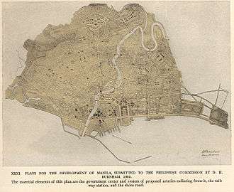
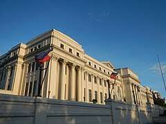
Under American control, a new, civilian-oriented Insular Government headed by Governor-General William Howard Taft invited city planner Daniel Burnham to adapt Manila to modern needs.[65] The Burnham Plan included the development of a road system, the use of waterways for transportation, and the beautification of Manila with waterfront improvements and construction of parks, parkways and buildings.[66][67]
The planned buildings included a government center occupying all of Wallace Field, which extends from Rizal Park to the present Taft Avenue. The Philippine Capitol was to rise at the Taft Avenue end of the field, facing toward the sea. Along with buildings for various government bureaus and departments, it would form a quadrangle with a lagoon in the center and a monument to José Rizal at the other end of the field. Of Burnham's proposed government center, only three units—the Legislative Building and the buildings of the Finance and Agricultural Departments—were completed when World War II erupted.
Japanese occupation and World War II
During the Japanese occupation of the Philippines, American soldiers were ordered to withdraw from Manila, and all military installations were removed on December 24, 1941. General Douglas MacArthur declared Manila an open city to prevent further death and destruction, but Japanese warplanes continued to bomb it. Manila was occupied by Japanese forces on January 2, 1942.
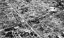
From February 3 to March 3, 1945, Manila was the site of the bloodiest battle in the Pacific theater of World War II. Some 100,000 civilians were killed in February.[68] At the end of the battle, Manila was recaptured by joint American and Philippine troops. It was the second most devastated city in the world, after Warsaw, during the Second World War. Almost all of the structures in the city, particularly in Intramuros, were destroyed.
It was after the many times when Manila was once again destroyed by war, when the city earned the moniker "The City of Our Affections". This nickname was given by National Artist and writer Nick Joaquin, in reference to the spirit of resilience the city has had in the face of the constant wars that have razed it and also in repeatedly surviving and rebuilding despite being the second-most natural disaster prone city in the world.[69] This is reflected in the noble spirit of Manileños and Filipinos who, despite having the second-most disaster prone capital city in the world and also the second-most war devastated capital city in recent history, are the most generous nationality in Southeast Asia and the 17th most generous nationality worldwide.[70] Manila (and the Philippines in general) is also among the top sources of missionaries worldwide.[71] This is explained by the fact that the Philippines is the most fervently Christian country in the world and is ranked as the 5th most religious country, globally.[72]
Post-war years and the martial law era (1945-1986)
In 1948, President Elpidio Quirino moved the seat of government of the Philippines to Quezon City, a new capital in the suburbs and fields northeast of Manila, created in 1939 during the administration of President Manuel L. Quezon.[73] The move ended any implementation of the Burnham Plan's intent for the government centre to be at Luneta.
With the Visayan-born Arsenio Lacson as its first elected mayor in 1952 (all mayors were appointed before this), Manila underwent The Golden Age,[74] once again earning its status as the "Pearl of the Orient", a moniker it earned before the Second World War. After Lacson's term in the 1950s, Manila was led by Antonio Villegas for most of the 1960s. Ramon Bagatsing (an Indian-Filipino) was mayor for nearly the entire 1970s until the 1986 People Power Revolution. Mayors Lacson, Villegas, and Bagatsing are collectively known as the "Big Three of Manila" for their contribution to the development of the city and their lasting legacy in improving the quality of life and welfare of the people of Manila.
During the administration of Ferdinand Marcos, the region of Metro Manila was created as an integrated unit with the enactment of Presidential Decree No. 824 on November 7, 1975. The area encompassed four cities and thirteen adjoining towns, as a separate regional unit of government.[75] On the 405th anniversary of the city's foundation on June 24, 1976, Manila was reinstated by President Marcos as the capital of the Philippines for its historical significance as the seat of government since the Spanish Period. Presidential Decree No. 940 states that Manila has always been to the Filipino people and in the eyes of the world, the premier city of the Philippines being the center of trade, commerce, education and culture.[76] Concurrent with the reinstatement of Manila as the capital, Ferdinand Marcos designated his wife, Imelda Marcos, as the first governor of Metro Manila. She started the rejuvenation of the city as she re-branded Manila as the "City of Man".[77]
During the martial law era, Manila became a hot-bed of resistance activity as youth and student demonstrators repeatedly clashed with the police and military which were subservient to the Marcos regime. After decades of resistance, the non-violent People Power Revolution (predecessor to the peaceful-revolutions that toppled the iron-curtain in Europe), led by Maria Corazon Aquino and Cardinal Jaime Sin, ousted the dictator Marcos from power.[78]
Contemporary period (1986-present)
From 1986–1992, Mel Lopez was mayor of Manila. During his early years, his administration was faced with 700 million pesos worth of debt and inherited an empty treasury. In the first eleven months, however, the debt was reduced to 365 million pesos and the city's income rose by around 70% eventually leaving the city with positive income until the end of his term. Lopez closed down numerous illegal gambling joints and jueteng. In January 1990, Lopez padlocked two Manila casinos operated by the Philippine Amusement and Gaming Corporation (PAGCOR), saying the billions it gained cannot make up for the negative effects gambling inflicts upon the people, particularly the youth. He also revived the Boys’ Town Haven (now referred to as “Boys Town”), rehabilitating its facilities to accommodate underprivileged children and provide them with livelihood and education.
In 1992, Alfredo Lim was elected mayor, the first Chinese-Filipino to hold the office. He was known for his anti-crime crusades. Lim was succeeded by Lito Atienza, who served as his vice mayor. Atienza was known for his campaign (and city slogan) "Buhayin ang Maynila" (Revive Manila), which saw the establishment of several parks and the repair and rehabilitation of the city's deteriorating facilities. He was the city's mayor for 3 terms (9 years) before being termed out of office. Lim once again ran for mayor and defeated Atienza's son Ali in the 2007 city election and immediately reversed all of Atienza's projects[79] claiming Atienza's projects made little contribution to the improvements of the city. The relationship of both parties turned bitter, with the two pitting again during the 2010 city elections in which Lim won against Atienza. Lim was sued by councilor Dennis Alcoreza on 2008 over human rights,[80] charged with graft over the rehabilitation of public schools,[81] and was heavily criticized for his haphazard resolution of the Rizal Park hostage taking incident, one of the deadliest hostage crisis in the Philippines. Later on, Vice Mayor Isko Moreno and 28 city councilors filed another case against Lim in 2012, stating that Lim's statement in a meeting were "life-threatening" to them.[82]

In 2012, DMCI Homes began constructing Torre de Manila, which became controversial for ruining the sight line of Rizal Park.[83] The tower is infamously known as "Terror de Manila" or the "national photobomber."[84] The Torre de Manila controversy is regarded as one of the most sensationalized heritage issues of the country. In 2017, the National Historical Commission of the Philippines erected a 'comfort woman' statue along Roxas Boulevard, which made Japan express regret that such statue was erected in the city despite the healthy relationship between Japan and the Philippines.[85][86]
In the 2013 elections, former President Joseph Estrada defeated Lim in the mayoral race. During his term, Estrada allegedly paid ₱5 billion in city debts and increased the city's revenues. In 2015, in line with President Noynoy Aquino's administration progress, the city became the most competitive city in the Philippines, making the city the best place for doing business and for living in. In the 2016 elections, Estrada narrowly won over Lim in their electoral rematch.[87] Throughout Estrada's term, numerous Filipino heritage sites were demolished, gutted out, or approved for demolition. Among such sites are the post-war Santa Cruz Building, Capitol Theater, El Hogar, old Magnolia Ice Cream Plant, and Rizal Memorial Stadium, among many others[88][89][90] Some of these sites were saved upon the intervention of various cultural agencies of government and heritage advocate groups against Estrada's orders.[91] In May 2019, Estrada claimed that Manila was debt-free,[92] however, two months later, the Commission on Audit verified that Manila has a total of 4.4 billion pesos in debt.[93]
Estrada, who was seeking for reelection for his third and final term lost to Isko Moreno in the 2019 local elections.[94][95] Moreno has served as the Vice Mayor under both the Lim and Estrada Administration. Estrada's defeat was seen as the end of their reign as a political clan, whose other family members run for various national and local positions.[96] After assuming office, Moreno initiated a city-wide cleanup against illegal vendors, signed an executive order promoting open governance, and vowed to stop bribery and corruption in the city.[97] Under his administration, several ordinances were signed, giving additional perks and privileges to Manila's senior citizens,[98] and monthly allowances for Grade 12 Manileño students in all public schools in the city, including students of Universidad de Manila and the University of the City of Manila.[99][100] The city government also undertook infrastructure projects such as the restoration of Jones Bridge to its near-original architecture, sprucing up the city's parks and plazas, and clearing the public roads of obstructions.
The city has an ordinance penalizing cat-calling since 2018, and is the second city in the Philippines to do so after Quezon City passed a similar ordinance in 2016.[101] Recently, the City Government is planning to revise existing curfew ordinance since the Supreme Court declared it unconstitutional on August 2017. Out of the three cities reviewed by the Supreme Court, namely: the City of Manila, Navotas and Quezon City; only the curfew ordinance of Quezon City was approved.[102][103]
Under the proposed form of federalism in the Philippines, Manila may no longer be the capital or Metro Manila may no longer be the seat of government. The committee has not yet decided on the federal capital and states that they are open to other proposals.[104][105]
On March 12, 2020, President Rodrigo Duterte placed the city and the entire metropolitan Manila under a community quarantine for one month starting March 15 due to the 2020 coronavirus pandemic.[106] A Luzon-wide "enhanced community quarantine" order was issued on March 16.[107]
Geography
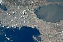
The City of Manila is situated on the eastern shore of Manila Bay, on the western edge of Luzon, 1,300 km (810 mi) from mainland Asia.[108] One of Manila's greatest natural resources is the protected harbor upon which it sits, regarded as the finest in all of Asia.[109] The Pasig River flows through the middle of city, dividing it into the north and south.[3][4] The overall grade of the city's central, built-up areas, is relatively consistent with the natural flatness of its overall natural geography, generally exhibiting only slight differentiation otherwise.
.JPG)
Almost all of Manila sits on top of centuries of prehistoric alluvial deposits built by the waters of the Pasig River and on some land reclaimed from Manila Bay. Manila's land has been altered substantially by human intervention, with considerable land reclamation along the waterfronts since the American colonial times. Some of the city's natural variations in topography have been evened out. As of 2013, Manila had a total area of 42.88 square kilometers.[3][4]
In 2017, the City Government approved five reclamation projects: the New Manila Bay–City of Pearl (New Manila Bay International Community) (407.43 hectares), Solar City (148 hectares), the Manila Harbour Center expansion (50 hectares), Manila Waterfront City (318 hectares)[110] and Horizon Manila (419 hectares). Once completed, it will increase the city's total area from 42.88 km2 (4,288 ha) to 58.3 km2 (5,830 ha). Another reclamation project is possible and when built, it will contain the in-city housing relocation projects.[111] Reclamation projects have been criticized by environmental activists and the Philippine Catholic Church, claiming that these are not sustainable and would put communities at risk of flooding.[112][113] In line of the upcoming reclamation projects, the Philippines and the Netherlands forged a cooperation to craft the ₱250 million Manila Bay Sustainable Development Master Plan to guide future decisions on programs and projects on Manila Bay.[114]
Climate
Under the Köppen climate classification system, Manila has a tropical savanna climate (Köppen Aw), bordering closely on a tropical monsoon climate (Köppen Am). Together with the rest of the Philippines, Manila lies entirely within the tropics. Its proximity to the equator means that temperatures are hot year-round especially during the daytime, rarely going below 19 °C (66.2 °F) or above 39 °C (102.2 °F). Temperature extremes have ranged from 14.5 °C (58.1 °F) on January 11, 1914,[115] to 38.6 °C (101.5 °F) on May 7, 1915.[116]
Humidity levels are usually very high all year round, making the temperature feel hotter than it is. Manila has a distinct dry season from late November through early March, and a relatively lengthy wet season that covers the remaining period with slightly cooler temperatures during the daytime. In the wet season, it rarely rains all day, but rainfall is very heavy during short periods. Typhoons usually occur from June to September.[117]
| Climate data for Port Area, Manila (1981–2010, extremes 1885–2012) | |||||||||||||
|---|---|---|---|---|---|---|---|---|---|---|---|---|---|
| Month | Jan | Feb | Mar | Apr | May | Jun | Jul | Aug | Sep | Oct | Nov | Dec | Year |
| Record high °C (°F) | 36.5 (97.7) |
35.6 (96.1) |
36.8 (98.2) |
38.0 (100.4) |
38.6 (101.5) |
37.6 (99.7) |
36.5 (97.7) |
35.6 (96.1) |
35.3 (95.5) |
35.8 (96.4) |
35.6 (96.1) |
34.6 (94.3) |
38.6 (101.5) |
| Average high °C (°F) | 29.6 (85.3) |
30.6 (87.1) |
32.1 (89.8) |
33.5 (92.3) |
33.2 (91.8) |
32.2 (90.0) |
31.2 (88.2) |
30.8 (87.4) |
31.0 (87.8) |
31.1 (88.0) |
30.9 (87.6) |
29.8 (85.6) |
31.3 (88.3) |
| Daily mean °C (°F) | 26.7 (80.1) |
27.4 (81.3) |
28.7 (83.7) |
30.1 (86.2) |
30.0 (86.0) |
29.3 (84.7) |
28.5 (83.3) |
28.3 (82.9) |
28.4 (83.1) |
28.4 (83.1) |
28.0 (82.4) |
27.0 (80.6) |
28.4 (83.1) |
| Average low °C (°F) | 23.8 (74.8) |
24.2 (75.6) |
25.3 (77.5) |
26.6 (79.9) |
26.9 (80.4) |
26.4 (79.5) |
25.9 (78.6) |
25.8 (78.4) |
25.7 (78.3) |
25.7 (78.3) |
25.1 (77.2) |
24.2 (75.6) |
25.5 (77.9) |
| Record low °C (°F) | 14.5 (58.1) |
15.6 (60.1) |
16.2 (61.2) |
17.2 (63.0) |
20.0 (68.0) |
20.1 (68.2) |
19.4 (66.9) |
18.0 (64.4) |
20.2 (68.4) |
19.5 (67.1) |
16.8 (62.2) |
15.7 (60.3) |
14.5 (58.1) |
| Average rainfall mm (inches) | 17.3 (0.68) |
14.2 (0.56) |
15.8 (0.62) |
23.7 (0.93) |
147.2 (5.80) |
253.5 (9.98) |
420.5 (16.56) |
432.4 (17.02) |
355.1 (13.98) |
234.8 (9.24) |
121.7 (4.79) |
67.4 (2.65) |
2,103.6 (82.82) |
| Average rainy days (≥ 0.1 mm) | 4 | 3 | 3 | 4 | 10 | 17 | 21 | 21 | 20 | 17 | 12 | 7 | 139 |
| Average relative humidity (%) | 72 | 69 | 67 | 66 | 71 | 76 | 79 | 81 | 80 | 78 | 75 | 74 | 74 |
| Mean monthly sunshine hours | 177 | 198 | 226 | 258 | 223 | 162 | 133 | 133 | 132 | 158 | 153 | 152 | 2,105 |
| Source #1: PAGASA[118][119] | |||||||||||||
| Source #2: Danish Meteorological Institute (sun, 1931–1960)[120] | |||||||||||||
Natural hazards
Swiss Re ranked Manila as the second riskiest capital city to live in, citing its exposure to natural hazards such as earthquakes, tsunamis, typhoons, floods and landslides.[14] The seismically active Marikina Valley Fault System poses a threat of a large-scale earthquake with an estimated magnitude between 6–7 and as high as 7.6[121] to Metro Manila and nearby provinces.[122] Manila has endured several deadly earthquakes, notably in 1645 and in 1677 which destroyed the stone and brick medieval city.[123] The Earthquake Baroque style was used by architects during the Spanish colonial period in order to adapt to the frequent earthquakes.[124]
Manila is hit with five to seven typhoons yearly.[125] In 2009, Typhoon Ketsana (Ondoy) struck the Philippines. It led to one of the worst floodings in Metro Manila and several provinces in Luzon with an estimated damages worth ₱11 billion ($237 million).[126][127] The floodings caused 448 deaths in Metro Manila alone. Following the aftermath of Typhoon Ketsana, the city began to dredge its rivers and improve its drainage network.
Pollution
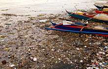
Due to industrial waste and automobiles, Manila suffers from air pollution,[128][129] affecting 98% of the population.[130] Air pollution alone causes more than 4,000 deaths yearly.[131] On a 1995 report, Ermita is regarded as Manila's most air polluted district due to open dump sites and industrial waste.[132] According to a report in 2003, the Pasig River is one of the most polluted rivers in the world with 150 tons of domestic waste and 75 tons of industrial waste dumped daily.[133] The city is the second biggest waste producer in the country with 1,151.79 tons (7,500.07 cubic meters) per day, after Quezon City which yields 1,386.84 tons or 12,730.59 cubic meters per day. Both cities were cited as having poor management in garbage collection and disposal.[134]
The Pasig River Rehabilitation Commission is in charge of cleaning up the Pasig River and tributaries for transportation, recreation and tourism purposes.[135] Rehabilitation efforts have resulted in the creation of parks along the riverside, along with stricter pollution controls.[136][137]
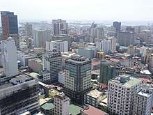
Cityscape


.jpg)
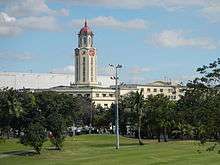
Manila is a planned city. In 1905, American Architect and Urban Planner Daniel Burnham was commissioned to design the new capital. His design for the city was based on the City Beautiful movement, which features broad streets and avenues radiating out from rectangles. The city is made up of fourteen city districts, according to Republic Act No. 409—the Revised Charter of the City of Manila—the basis of which officially sets the present-day boundary of the city.[138] Two districts were later created, which are Santa Mesa (partitioned off from Sampaloc) and San Andres (partitioned off from Santa Ana).
Manila's mix of architectural styles reflects the turbulent history of the city and country. During the Second World War, Manila was razed to the ground by the Japanese forces and the shelling of American forces. After the liberation, rebuilding began and most of the historical buildings were thoroughly reconstructed. However, some of the historic buildings from the 19th century that had been preserved in reasonably reconstructible form were nonetheless eradicated or otherwise left to deteriorate. Manila's current urban landscape is one of modern and contemporary architecture.
Architecture


Manila is known for its eclectic mix of architecture that shows a wide range of styles spanning different historical and cultural periods. Architectural styles reflect American, Spanish, Chinese, and Malay influences.[139] Prominent Filipino architects such as Antonio Toledo, Felipe Roxas, Juan M. Arellano and Tomás Mapúa have designed significant buildings in Manila such as churches, government offices, theaters, mansions, schools and universities.
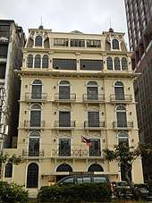
Manila is also famed for its Art Deco theaters. Some of these were designed by National Artists for Architecture such as Juan Nakpil and Pablo Antonio. Unfortunately most of these theaters were neglected, and some of it have been demolished. The historic Escolta Street in Binondo features many buildings of Neoclassical and Beaux-Arts architectural style, many of which were designed by prominent Filipino architects during the American Rule in the 1920s to the late 1930s. Many architects, artists, historians and heritage advocacy groups are pushing for the rehabilitation of Escolta Street, which was once the premier street of the Philippines.[140]
Almost all of Manila's prewar and Spanish colonial architecture were destroyed during its battle for liberation by the intensive bombardment of the United States Air Force during World War II. Reconstruction took place afterwards, replacing the destroyed historic Spanish-era buildings with modern ones, erasing much of the city's character. Some buildings destroyed by the war have been reconstructed, such as the Old Legislative Building (now the National Museum of Fine Arts), Ayuntamiento de Manila (now the Bureau of the Treasury) and the currently under construction San Ignacio Church and Convent (as the Museo de Intramuros). There are plans to rehabilitate and/or restore several neglected historic buildings and places such as Plaza Del Carmen, San Sebastian Church and the Manila Metropolitan Theater. Spanish-era shops and houses in the districts of Binondo, Quiapo, and San Nicolas are also planned to be restored, as a part of a movement to restore the city to its former glory and its beautiful prewar state.[141][142]
Since Manila is prone to earthquakes, the Spanish colonial architects invented the style called Earthquake Baroque which the churches and government buildings during the Spanish colonial period adopted.[124] As a result, succeeding earthquakes of the 18th and 19th centuries barely affected Manila, although it did periodically level the surrounding area. Modern buildings in and around Manila are designed or have been retrofitted to withstand an 8.2 magnitude quake in accordance to the country's building code.[143]
Demographics
| Population Census of Manila | ||
|---|---|---|
| Year | Pop. | ±% p.a. |
| 1903 | 219,928 | — |
| 1918 | 283,613 | +1.71% |
| 1939 | 623,492 | +3.82% |
| 1948 | 983,906 | +5.20% |
| 1960 | 1,138,611 | +1.22% |
| 1970 | 1,330,788 | +1.57% |
| 1975 | 1,479,116 | +2.14% |
| 1980 | 1,630,485 | +1.97% |
| 1990 | 1,601,234 | −0.18% |
| 1995 | 1,654,761 | +0.62% |
| 2000 | 1,581,082 | −0.97% |
| 2007 | 1,660,714 | +0.68% |
| 2010 | 1,652,171 | −0.19% |
| 2015 | 1,780,148 | +1.43% |
| Source: Philippine Statistics Authority[144][145][146][147] | ||
According to the 2015 census, the population of the city was 1,780,148, making it the second most populous city in the Philippines.[5] Manila is the most densely populated city in the world, with 41,515 inhabitants per km2 in 2015.[6] District 6 is listed as being the most dense with 68,266 inhabitants per km2, followed by District 1 with 64,936 and District 2 with 64,710. District 5 is the least densely populated area with 19,235.[148]
Manila's population density dwarfs that of Kolkata (24,252 inhabitants per km2),[149] Mumbai (20,482 inhabitants per km2), Paris (20,164 inhabitants per km2), Dhaka (29,069 inhabitants per km2), Shanghai (16,364 inhabitants per km2, with its most dense district, Nanshi, having a density of 56,785 inhabitants per km2), and Tokyo (10,087 inhabitants per km2).[148]
Manila has been presumed to be the Philippines' largest city since the establishment of a permanent Spanish settlement with the city eventually becoming the political, commercial and ecclesiastical capital of the country.[150] Its population increased dramatically since the 1903 census as the population tended to move from rural areas to towns and cities. In the 1960 census, Manila became the first Philippine city to breach the one million mark (more than 5 times of its 1903 population). The city continued to grow until the population somehow "stabilized" at 1.6 million and experienced alternating increase and decrease starting the 1990 census year. This phenomenon may be attributed to the higher growth experience by suburbs and the already very high population density of city. As such, Manila exhibited a decreasing percentage share to the metropolitan population[151] from as high as 63% in the 1950s to 27.5%[152] in 1980 and then to 13.8% in 2015. The much larger Quezon City marginally surpassed the population of Manila in 1990 and by the 2015 census already has 1.1 million people more. Nationally, the population of Manila is expected to be overtaken by cities with larger territories such as Caloocan and Davao City by 2020.[153]
The vernacular language is Filipino, based mostly on the Tagalog language of surrounding areas, and this Manila form of spoken Tagalog has essentially become the lingua franca of the Philippines, having spread throughout the archipelago through mass media and entertainment. English is the language most widely used in education, business, and heavily in everyday usage throughout Metro Manila and the Philippines itself.
A scant number of residents can speak Spanish, and many children of Japanese, Indian, and other origins also speak their parents' languages at home, aside from English and/or Filipino for everyday use. A variant of Southern Min, Hokkien (locally known as Lan'nang-oe) is mainly spoken by the city's Chinese-Filipino community. According to data provided by the Bureau of Immigration, a total of 3.12 million Chinese citizens arrived in the Philippines from January 2016 to May 2018.[154]
Crime
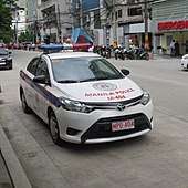
Crime in Manila is concentrated in areas associated with poverty, drug abuse, and gangs. Crime in the city is also directly related to its changing demographics and unique criminal justice system. Illegal drug trade is a major problem of the city. In Metro Manila alone, 92% of the barangays are affected by illegal drugs.[155]
From 2010 to 2015, the city had the second highest index crime rates in the Philippines, with 54,689 cases or an average of about 9,100 cases per year.[156] By October 2017, the Manila Police District (MPD) reported a 38.7% decrease in index crimes, from 5,474 cases in 2016 to only 3,393 in 2017. MPD's crime solution efficiency also improved, wherein six to seven out of 10 crimes have been solved by the city police force.[157] MPD was cited was the Best Police District in Metro Manila in 2017 for registering the highest crime solution efficiency.[158]
Religion
Christianity
As a result of Spanish cultural influence, Manila is a predominantly Christian city. As of 2010, Roman Catholics were 93.5% of the population, followed by adherents of the Iglesia ni Cristo (1.9%); various Protestant churches (1.8%); and Buddhists (1.1%). Members of Islam and other religions make up the remaining 1.4% of its population.[159]
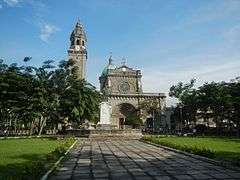
Manila is the seat of prominent Catholic churches and institutions. There are 113 Catholic churches within the city limits; 63 are considered as major shrines, basilicas, or a cathedral.[160] The Manila Cathedral is the seat of the Roman Catholic Archdiocese of Manila and the oldest established church in the country.[161] Aside from the Manila Cathedral, there are also three other basilicas in the city: Quiapo Church, Binondo Church, and the Minor Basilica of San Sebastián. The San Agustín Church in Intramuros is a UNESCO World Heritage Site and is one of the two fully air-conditioned Catholic churches in the city. Manila also has other parishes located throughout the city, with some of them dating back to the Spanish Colonial Period when the city serves as the base for numerous Catholic missions both within the Philippines and to Asia beyond.
Several Mainline Protestant denominations are headquartered in the city. St. Stephen's Parish pro-cathedral in the Santa Cruz district is the see of the Episcopal Church in the Philippines' Diocese of Central Philippines, while align Taft Avenue are the main cathedral and central offices of the Iglesia Filipina Independiente (also called the Aglipayan Church, a national church that was a product of the Philippine Revolution). Other faiths like The Church of Jesus Christ of Latter-day Saints (Mormons) has several churches in the city.
The indigenous Iglesia ni Cristo has several locales (akin to parishes) in the city, including its very first chapel (now a museum) in Punta, Santa Ana. Evangelical, Pentecostal and Seventh-day Adventist denominations also thrive within the city. The headquarters of the Philippine Bible Society is in Manila. Also, the main campus of the Cathedral of Praise is located along Taft Avenue. Jesus Is Lord Church Worldwide also has several branches and campuses in Manila, and celebrates its anniversary yearly at the Burnham Green and Quirino Grandstand in Rizal Park.
 Manila Cathedral is the seat of Roman Catholic Archdiocese of Manila
_Manila%2C_Filipinas..jpg)
.JPG) San Agustín Church in Intramuros, a UNESCO World Heritage Site.
San Agustín Church in Intramuros, a UNESCO World Heritage Site. Binondo Church serves the Roman Catholic Chinese community
 Quiapo Church is the home to the iconic Black Nazarene which celebrates its feasts every January 9
Other faiths
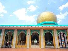
There are many Buddhist and Taoist temples in the city serving the Chinese Filipino community. Quiapo is home to a sizable Muslim population which worships at Masjid Al-Dahab. Members of the Indian expatriate population have the option of worshiping at the large Hindu temple in the city, or at the Sikh gurdwara along United Nations Avenue. The National Spiritual Assembly of the Bahá'ís of the Philippines, the governing body of the Filipino Bahá'í community, is headquartered near Manila's eastern border with Makati.
Economy
Manila is a major center for commerce, banking and finance, retailing, transportation, tourism, real estate, new media as well as traditional media, advertising, legal services, accounting, insurance, theater, fashion, and the arts in the Philippines. Around 60,000 establishments operate in the city.[163]
The National Competitiveness Council of the Philippines which annually publishes the Cities and Municipalities Competitiveness Index (CMCI), ranks the cities, municipalities and provinces of the country according to their economic dynamism, government efficiency and infrastructure. According to the 2016 CMCI, Manila was the second most competitive city in the Philippines.[164] Manila placed third in the Highly Urbanized City (HUC) category.[165] Manila held the title country's most competitive city in 2015, and since then has been making it to the top 3, assuring that the city is consistently one of the best place to live in and do business.[166] Lars Wittig, the country manager of Regus Philippines, hailed Manila as the third best city in the country to launch a start-up business.[167]
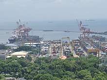
The Port of Manila is the largest seaport in the Philippines, making it the premier international shipping gateway to the country. The Philippine Ports Authority is the government agency responsible to oversee the operation and management of the ports. The International Container Terminal Services Inc. cited by the Asian Development Bank as one of the top five major maritime terminal operators in the world[168][169] has its headquarters and main operations on the ports of Manila. Another port operator, the Asian Terminal Incorporated, has its corporate office and main operations in the Manila South Harbor and its container depository located in Santa Mesa.
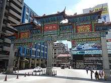
Binondo, the oldest and one of the largest Chinatowns in the world, was the center of commerce and business activities in the city. Numerous residential and office skyscrapers are found within its medieval streets. Plans to make the Chinatown area into a business process outsourcing (BPO) hub progresses and is aggressively pursued by the city government of Manila. 30 buildings are already identified to be converted into BPO offices. These buildings are mostly located along the Escolta Street of Binondo, which are all unoccupied and can be converted into offices.[170]
Divisoria in Tondo is known as the "shopping mecca of the Philippines." Numerous shopping malls are located in this place, which sells products and goods at bargain price. Small vendors occupy several roads that causes pedestrian and vehicular traffic. A famous landmark in Divisoria is the Tutuban Center, a large shopping mall that is a part of the Philippine National Railways' Main Station. It attracts 1 million people every month, but is expected to add another 400,000 people when the Line 2 West Extension is constructed, which is set to make it as Manila's busiest transfer station.[171]
Diverse manufacturers within the city produce industrial-related products such as chemicals, textiles, clothing, and electronic goods. Food and beverages and tobacco products also produced. Local entrepreneurs continue to process primary commodities for export, including rope, plywood, refined sugar, copra, and coconut oil. The food-processing industry is one of the most stable major manufacturing sector in the city.
The Pandacan Oil Depot houses the storage facilities and distribution terminals of the three major players in the country's petroleum industry, namely Caltex Philippines, Pilipinas Shell and Petron Corporation. The oil depot has been a subject of various concerns, including its environmental and health impact to the residents of Manila. The Supreme Court has ordered that the oil depot to be relocated outside the city by July 2015,[172][173] but it failed to meet this deadline. Most of the oil depot facility inside the 33 hectare compound have been demolished, and plans are put into place to transform it into a transport hub or even a food park.
Manila is a major publishing center in the Philippines.[174] Manila Bulletin, the Philippines' largest broadsheet newspaper by circulation, is headquartered in Intramuros.[175] Other major publishing companies in the country like The Manila Times, The Philippine Star and Manila Standard Today are headquartered in the Port Area. The Chinese Commercial News, the Philippines' oldest existing Chinese-language newspaper, and the country's third-oldest existing newspaper[176] is headquartered in Binondo. DWRK used to have its studio along FEMS Tower 1 along South Superhighway before transferring to the MBC Building at the CCP Complex in 2008.
Manila serves as the headquarters of the Central Bank of the Philippines which is located along Roxas Boulevard.[177] Some universal banks in the Philippines that has its headquarters in the city are the Landbank of the Philippines and Philippine Trust Company. Unilever Philippines used to have its corporate office along United Nations Avenue in Paco before transferring to Bonifacio Global City in 2016.[178] Toyota, a company listed in the Forbes Global 2000, also has its regional office along UN Avenue.
Tourism
Manila welcomes over 1 million tourists each year.[174] Major tourist destinations include the historic Walled City of Intramuros, the Cultural Center of the Philippines Complex,[note 1] Manila Ocean Park, Binondo (Chinatown), Ermita, Malate, Manila Zoo, the National Museum Complex and Rizal Park.[179] Both the historic Walled City of Intramuros and Rizal Park were designated as flagship destinations and as a tourism enterprise zones in the Tourism Act of 2009.[180]
Rizal Park, also known as Luneta Park, is the national park and the largest urban park in Asia[181] with an area of 58 hectares (140 acres),[182] The park was constructed as an honor and dedication to the country's national hero José Rizal, who was executed by the Spaniards on charges of subversion. The flagpole west of the Rizal Monument is the Kilometer Zero marker for distances to the rest of the country. The park was managed by the National Parks and Development Committee.
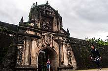
The 0.67 square kilometers (0.26 sq mi) Walled City of Intramuros is the historic center of Manila. It is administered by the Intramuros Administration, an attached agency of the Department of Tourism. It contains the famed Manila Cathedral and the 18th Century San Agustin Church, a UNESCO World Heritage Site. Kalesa is a popular mode of transportation for tourists in Intramuros and nearby places including Binondo, Ermita and Rizal Park.[183] Known as the oldest chinatown in the world, Binondo was established on 1521 and it was already a hub of Chinese commerce even before the Spaniards colonized the Philippines. Its main attractions are Binondo Church, Filipino-Chinese Friendship Arch, Seng Guan Buddhist temple and authentic Chinese restaurants.
Manila is designated as the country's pioneer of medical tourism, expecting it to generate $1 billion in revenue annually.[184] However, lack of progressive health system, inadequate infrastructure and the unstable political environment are seen as hindrances for its growth.[185]
Shopping

Manila is regarded as one of the best shopping destinations in Asia.[186][187] Major shopping malls, department stores, markets, supermarkets and bazaars thrive within the city.
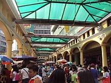
One of the city's famous shopping destinations is Divisoria, home to numerous shopping malls in the city, including the famed Tutuban Center and the Lucky Chinatown Mall. It is also dubbed as the shopping mecca of the Philippines where everything is sold at bargain price. There are almost 1 million shoppers in Divisoria according to the Manila Police District.[188] Binondo, the oldest Chinatown in the world,[52] is the city's center of commerce and trade for all types of businesses run by Filipino-Chinese merchants with a wide variety of Chinese and Filipino shops and restaurants. Quiapo is referred to as the "Old Downtown", where tiangges, markets, boutique shops, music and electronics stores are common. C.M. Recto Avenue is where lots of department stores are located.
Robinsons Place Manila is the largest shopping mall in the city.[189] The mall was the second and the largest Robinsons Malls built. SM Supermall operates two shopping malls in the city which are the SM City Manila and SM City San Lazaro. SM City Manila is located on the former grounds of YMCA Manila beside the Manila City Hall in Ermita, while SM City San Lazaro is built on the site of the former San Lazaro Hippodrome in Santa Cruz. The building of the former Manila Royal Hotel in Quiapo, which is famed for its revolving restaurant atop, is now the SM Clearance Center that was established in 1972.[190] The site of the first SM Store is located at Carlos Palanca Sr. (formerly Echague) Street in San Miguel.
Culture
Museums
As the cultural center of the Philippines, Manila is the home to a number of museums. The National Museum Complex of the National Museum of the Philippines, located in Rizal Park, is composed of the National Museum of Fine Arts, the National Museum of Anthropology, the National Museum of Natural History, and the National Planetarium. The famous painting of Juan Luna, the Spoliarium, can be found in the complex. The city also hosts the repository of the country's printed and recorded cultural heritage and other literary and information resources, the National Library. Museums established or run by educational institutions are the Mabini Shrine, the DLS-CSB Museum of Contemporary Art and Design, UST Museum of Arts and Sciences, and the UP Museum of a History of Ideas.
_Facade_-_Front_View.jpg)
Bahay Tsinoy, one of Manila's most prominent museums, documents the Chinese lives and contributions in the history of the Philippines. The Intramuros Light and Sound Museum chronicles the Filipinos desire for freedom during the revolution under Rizal's leadership and other revolutionary leaders. The Metropolitan Museum of Manila is a museum of modern and contemporary visual arts exhibits the Filipino arts and culture.
Other museums in the city are the Museum of Manila, the city-owned museum that exhibits the city's culture and history, Museo Pambata, a children's museum and a place of hands-on discovery and fun learning, and Plaza San Luis which is an outdoor heritage public museum that contains a collection of nine Spanish Bahay na Bató houses. Ecclesiastical museums in the located in the city are the Parish of the Our Lady of the Abandoned in Santa Ana, the San Agustin Church Museum and the Museo de Intramuros which houses the ecclesiastical art collection of the Intramuros Administration in the reconstructed San Ignacio Church and Convent.
Sports
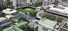

Sports in Manila have a long and distinguished history. The city's, and in general the country's main sport is basketball, and most barangays have a basketball court or at least a makeshift basketball court, with court markings drawn on the streets. Larger barangays have covered courts where inter-barangay leagues are held every summer (April to May). Manila has many sports venues, such as the Rizal Memorial Sports Complex and San Andres Gym, the home of the now defunct Manila Metrostars.[191] The Rizal Memorial Sports Complex houses the Rizal Memorial Track and Football Stadium, the Baseball Stadium, Tennis Courts, the Rizal Memorial Coliseum and the Ninoy Aquino Stadium (the latter two are indoor arenas). The Rizal complex had hosted several multi-sport events, such as the 1954 Asian Games and the 1934 Far Eastern Games. Whenever the country hosts the Southeast Asian Games, most of the events are held at the complex, but in the 2005 Games, most events were held elsewhere. The 1960 ABC Championship and the 1973 ABC Championship, forerunners of the FIBA Asia Championship, was hosted by the memorial coliseum, with the national basketball team winning on both tournaments. The 1978 FIBA World Championship was held at the coliseum although the latter stages were held in the Araneta Coliseum in Quezon City, Southeast Asia's largest indoor arena at that time.
Manila also hosts several well-known sports facilities such as the Enrique M. Razon Sports Center and the University of Santo Tomas Sports Complex, both of which are private venues owned by a university; collegiate sports are also held, with the University Athletic Association of the Philippines and the National Collegiate Athletic Association basketball games held at Rizal Memorial Coliseum and Ninoy Aquino Stadium, although basketball events had transferred to San Juan's Filoil Flying V Arena and the Araneta Coliseum in Quezon City. Other collegiate sports are still held at the Rizal Memorial Sports Complex. Professional basketball also used to play at the city, but the Philippine Basketball Association now holds their games at Araneta Coliseum and Cuneta Astrodome at Pasay; the now defunct Philippine Basketball League played some of their games at the Rizal Memorial Sports Complex.
The Manila Storm are the city's rugby league team training at Rizal Park (Luneta Park) and playing their matches at Southern Plains Field, Calamba, Laguna. Previously a widely played sport in the city, Manila is now the home of the only sizable baseball stadium in the country, at the Rizal Memorial Baseball Stadium. The stadium hosts games of Baseball Philippines; Lou Gehrig and Babe Ruth were the first players to score a home run at the stadium at their tour of the country on December 2, 1934.[192] Another popular sport in the city are cue sports, and billiard halls are a feature in most barangays. The 2010 World Cup of Pool was held at Robinsons Place Manila.[193]
The Rizal Memorial Track and Football Stadium hosted the first FIFA World Cup qualifier in decades when the Philippines hosted Sri Lanka in July 2011. The stadium, which was previously unfit for international matches, had undergone a major renovation program before the match.[194] The stadium also hosted its first rugby test when it hosted the 2012 Asian Five Nations Division I tournaments.[195]
Festivities and holidays
Manila celebrates civic and national holidays. Since most of the city's citizens are Roman Catholics as a result of the Spanish colonization,[196] most of the festivities are religious in nature. Manila Day, which celebrates the city's founding on June 24, 1571 by Spanish conquistador Miguel López de Legazpi, was first proclaimed by Herminio A. Astorga (then Vice Mayor of Manila) on June 24, 1962. It has been annually commemorated under the patronage of John the Baptist, and has always been declared by the national government as a special non-working holiday through Presidential Proclamations. Each of the city's 896 barangays also have their own festivities guided by their own patron saint.
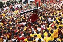
The city is also the host to the Procession of the Feast of the Black Nazarene (Traslacíon), held every January 9, which draws millions of Catholic devotees. Other religious festivities held in Manila are the Feast of Santo Niño in Tondo and Pandacan held on the third Sunday of January, the Feast of the Nuestra Señora de los Desamparados de Manila (Our Lady of the Abandoned), the patron saint of Santa Ana which was held every May 12, and the Flores de Mayo. Non-religious holidays include the New Year's Day, National Heroes' Day, Bonifacio Day and Rizal Day.
Law and government
Manila—officially known as the City of Manila—is the national capital of the Philippines and is classified as a Special City (according to its income)[197][198] and a Highly Urbanized City (HUC). The mayor is the chief executive, and is assisted by the vice mayor, the 36-member City Council, six Congressmen, the President of the Association of Barangay Captains, and the President of the Sangguniang Kabataan. The members of the City Council are elected as representatives of specific congressional districts within the city. The city, however, have no control over Intramuros and the Manila North Harbor. The historic Walled City is administered by the Intramuros Administration, while the Manila North Harbor is managed by the Philippine Ports Authority. Both are national government agencies. The barangays that have jurisdictions over these places only oversee the welfare of the city's constituents and cannot exercise their executive powers. Manila has a total of 15,489 personnel complement by the end of 2018.[199]
The current mayor is Francisco "Isko Moreno" Domagoso, who previously served as the city's vice mayor. The current vice mayor is Dr. Maria Shielah "Honey" Lacuna-Pangan, daughter of former Manila Vice Mayor Danny Lacuna. The mayor and the vice mayor are term-limited by up to 3 terms, with each term lasting for 3 years.
Manila, being the seat of political power of the Philippines, has several national government offices headquartered at the city. Planning for the development for being the center of government started during the early years of American colonization when they envisioned a well-designed city outside the walls of Intramuros. The strategic location chosen was Bagumbayan, a former town which is now the Rizal Park to become the center of government and a design commission was given to Daniel Burnham to create a master plan for the city patterned after Washington, D.C. These improvements were eventually abandoned under the Commonwealth Government of Manuel L. Quezon.
A new government center was to be built on the hills northeast of Manila, or what is now Quezon City. Several government agencies have set up their headquarters in Quezon City but several key government offices still reside in Manila. However, many of the plans were substantially altered after the devastation of Manila during World War II and by subsequent administrations.
The city, as the capital, still hosts the Office of the President, as well as the president's official residence. Aside from these, important government agencies and institutions such as the Supreme Court, the Court of Appeals, the Bangko Sentral ng Pilipinas, the Departments of Budget and Management, Finance, Health, Justice, Labor and Employment and Public Works and Highways still call the city home. Manila also hosts important national institutions such as the National Library, National Archives, National Museum and the Philippine General Hospital.
Congress previously held office at the Old Congress Building. In 1972, due to declaration of martial law, Congress was dissolved; its successor, the unicameral Batasang Pambansa, held office at the new Batasang Pambansa Complex. When a new constitution restored the bicameral Congress, the House of Representatives stayed at the Batasang Pambansa Complex, while the Senate remained at the Old Congress Building. In May 1997, the Senate transferred to a new building it shares with the Government Service Insurance System at reclaimed land at Pasay. The Supreme Court will also transfer to its new campus at Bonifacio Global City, Taguig in 2019.[200]
Finance
In the 2018 Annual Audit Report published by the Commission on Audit, it is stated that the total revenue of the City of Manila amounts to ₱14.1 billion.[199] It is one of the cities with the highest tax collection and internal revenue allotment.[201] Manila collects an annual tax revenue amounting to ₱7.3 billion. The city's total Internal Revenue Allotment (IRA), coming from the National Treasury, is at ₱2.94 billion. Meanwhile, its total assets was worth ₱40.7 billion in 2018.[199] The City of Manila has the highest budget allocation to healthcare among all the cities and municipalities in the Philippines, which maintains the six district hospitals, 59 health centers and lying-in clinic, and healthcare programs.
Barangays and districts
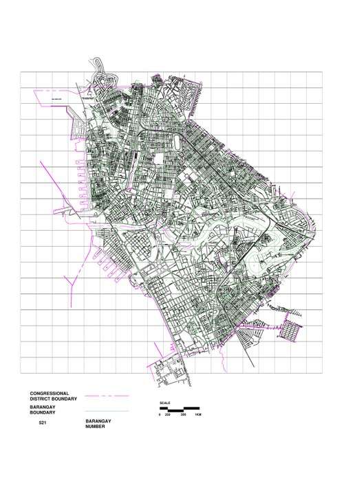


Manila is made up of 896 barangays,[202] which are grouped into 100 Zones for statistical convenience. Manila has the most number of barangays in the Philippines.[203] Attempts at reducing its number have not prospered despite local legislation—Ordinance 7907, passed on April 23, 1996—reducing the number from 896 to 150 by merging existing barangays, because of the failure to hold a plebiscite.[204]
- District I (2015 population: 415,906)[205] covers the western part of Tondo and is made up of 136 barangays. It is the most densely populated Congressional District and was also known as Tondo I. The district is the home to one of the biggest urban poor communities. The Smokey Mountain in Balut Island is once known as the largest landfill where thousands of impoverished people lives in the slums. After the closure of the landfill in 1995, mid-rise housing buildings were built in place. This district also contains the Manila North Harbour Centre, the Manila North Harbor, and the Manila International Container Terminal of the Port of Manila.
- District II (2015 population: 215,457)[205] covers the eastern part of Tondo which contains 122 barangays. It is also referred to as Tondo II. It contains Gagalangin, a prominent place in Tondo, and Divisoria, a popular shopping place in the Philippines and the site of the Main Terminal Station of the Philippine National Railways.
- District III (2015 population: 221,780)[205] covers Binondo, Quiapo, San Nicolas and Santa Cruz. It contains 123 barangays and encompasses the so-called "Downtown Manila" or the historic business district of the city and the oldest Chinatown in the world.
- District IV (2015 population: 265,046)[205] covers Sampaloc and some parts of Santa Mesa. It contains 192 barangays and has numerous colleges and universities, which were located along the city's "University Belt", a de facto sub-district. The University of Santo Tomas is located here, the oldest existing university in Asia which was established in 1611.
- District V (2015 population: 366,714)[205] covers Ermita, Malate, Port Area, Intramuros, San Andres Bukid, and a portion of Paco. It is made up of 184 barangays. The historic Walled City is located here, along with Manila Cathedral and San Agustin Church, a UNESCO World Heritage Site.
- District VI (2007 population: 295,245)[205] covers Pandacan, San Miguel, Santa Ana, Santa Mesa and a portion of Paco. It contains 139 barangays. Santa Ana district is known for its 18th Century Santa Ana Church and historic ancestral houses.
| |||||||||||||||||||||||||||||||||||||||||||||||||||||||||||||||||||||||||||||||||||||||||||||||||||||||||||||||||||||||||||||||||||||||||||||||
Infrastructure
Housing
Development of public housing in the city began in the 1930s when the United States rule over the Philippines. Americans have to deal with the problem of sanitation and concentration of settlers around business areas. Business codes and sanitation laws were implemented in the 1930s. During this period until the 1950s, new communities were opened for relocation. Among these were Projects 1–8 in Diliman, Quezon City and the Vitas tenement houses in Tondo. The government implemented the Public Housing Policy in 1947 that established the People's Homesite and Housing Corporation (PHHC). A few years later, it put up the Slum Clearance Committee which, with the help of the PHHC, relocated thousands of families from Tondo and Quezon City to Sapang Palay in San Jose del Monte, Bulacan in the 1960s.
In 2016, the national government completed several medium-rise houses for 300 Manila residents whose slum community was destroyed by a fire in 2011.[206] Meanwhile, the city government plans to retrofit dilapidated tenements within the city,[207] and will construct new housing buildings for the city's informal settlers such as the 14-storey Tondominium 1 and Tondomium 2 buildings, containing 42-square meter, two-bedroom units. The construction of these new in-city vertical housing projects was funded by a loan from the Development Bank of the Philippines and the Land Bank of the Philippines.[208][209] A multitude of other vertical housing projects are in development.
Transportation
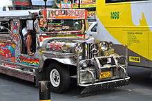
(2018-02-22).jpg)
One of the more famous modes of transportation in Manila is the jeepney. Patterned after U.S. Army jeeps, these have been in use since the years immediately following World War II.[210] The Tamaraw FX, the third generation Toyota Kijang, which competed directly with jeepneys and followed fixed routes for a set price, once plied the streets of Manila. They were replaced by the UV Express. All types of public road transport plying Manila are privately owned and operated under government franchise.
On a for-hire basis, the city is served by numerous taxicabs, "tricycles" (motorcycles with sidecars, the Philippine version of the auto rickshaw), and "trisikads" or "sikads", which are also known as "kuligligs" (bicycles with a sidecars, the Philippine version of pedicabs). In some areas, especially in Divisoria, motorized pedicabs are popular. Spanish-era horse-drawn calesas are still a popular tourist attraction and mode of transportation in the streets of Binondo and Intramuros. Manila will phase out all gasoline-run tricycles and pedicabs and replace them with electric tricycles (e-trikes), and plans to distribute 10,000 e-trikes to qualified tricycle drivers from the city.[211][212] As of January 2018, the city has already distributed e-trikes to a number of drivers and operators in Binondo, Ermita, Malate and Santa Cruz.[213]
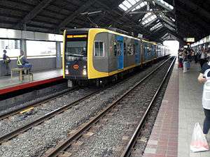
The city is serviced by Line 1 and Line 2, which form the Manila Light Rail Transit System, as well as the Manila Metro Rail Transit System, currently made up of one line (Line 3) with several more in development. Development of the railway system began in the 1970s under the presidency of Ferdinand Marcos, when Line 1 was built, making it the first light rail transport in Southeast Asia, though despite the name "light rail", Line 1 operates as a Light Metro running on dedicated right-of-way. Line 2 on the other hand, operates as a full-metro heavy-rail system. These systems are currently undergoing a multibillion-dollar expansion.[214] Line 1 runs along the length of Taft Avenue (N170/R-2) and Rizal Avenue (N150/R-9), and Line 2 runs along Claro M. Recto Avenue (N145/C-1) and Ramon Magsaysay Boulevard (N180/R-6) from Santa Cruz, through Quezon City, up to Masinag in Antipolo, Rizal. Line 3 runs from Taft Avenue, where it intersects with the EDSA station on Line 1, northward through the eastern part of the city, eventually meeting with Line 2 at Araneta Center-Cubao Station before eventually terminating in the north of the city at North Avenue Station, with plans to extend the line to link up with Roosevelt Station at the northern terminus of Line 1.
The main terminal of the Philippine National Railways lies within the city. One commuter railway within Metro Manila is in operation. The line runs in a general north-south direction from Tutuban (Tondo) toward the province of Laguna. The Port of Manila, located at the western section of the city at the vicinity of Manila Bay, is the chief seaport of the Philippines. The Pasig River Ferry Service which runs on the Pasig River is another form of transportation. The city is also served by the Ninoy Aquino International Airport and Clark International Airport.
In 2006, Forbes magazine ranked Manila the world's most congested city. According to Waze's 2015 "Global Driver Satisfaction Index", Manila is the town with the worst traffic worldwide.[215] Manila is notorious for its frequent traffic jams and high densities.[216] The government has undertaken several projects to alleviate the traffic in the city. Some of the projects include: the proposed construction of a new viaduct or underpass at the intersection of España Boulevard and Lacson Avenue,[217] the construction of the Metro Manila Skyway Stage 3, the proposed Line 2 West Extension Project from Recto Avenue to Pier 4 of the Manila North Harbor,[218] the proposed construction of the PNR East-West line which will run through España Boulevard up to Quezon City, and the expansion and widening of several national and local roads. However, such projects have yet to make any meaningful impact, and the traffic jams and congestion continue unabated.[219]
The Metro Manila Dream Plan seeks to address these urban transport problems. It consists of a list of short term priority projects and medium to long term infrastructure projects that will last up to 2030.[220][221]
Water and electricity
Water services used to be provided by the Metropolitan Waterworks and Sewerage System, which served 30% of the city with most other sewage being directly dumped into storm drains, septic tanks, or open canals.[222] MWSS was privatized in 1997, which split the water concession into the east and west zones. The Maynilad Water Services took over the west zone of which Manila is a part. It now provides the supply and delivery of potable water and sewerage system in Manila,[223] but it does not provide service to the southeastern part of the city which belongs to the east zone that is served by Manila Water. Electric services are provided by Meralco, the sole electric power distributor in Metro Manila.
Healthcare
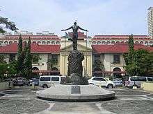
The Manila Health Department is responsible for the planning and implementation of the health care programs provided by the city government. It operates 59 health centers and six city-run hospitals, which are free of charge for the city's constituents. The six public city-run hospitals are the Ospital ng Maynila Medical Center, Ospital ng Sampaloc, Gat Andres Bonifacio Memorial Medical Center, Ospital ng Tondo, Santa Ana Hospital, and Justice Jose Abad Santos General Hospital.[224] Manila is also the site of the Philippine General Hospital, the tertiary state-owned hospital administered and operated by the University of the Philippines Manila. The city is also planning to put up an education, research and hospital facility for cleft-palate patients,[225][226] as well as establishing the first children's surgical hospital in Southeast Asia.[227]
Manila's healthcare is also provided by private corporations. Private hospitals that operates in the city are the Manila Doctors Hospital, Chinese General Hospital and Medical Center, Dr. José R. Reyes Memorial Medical Center, Metropolitan Medical Center, Our Lady of Lourdes Hospital, and the University of Santo Tomas Hospital.
The Department of Health (DOH) has its main office in Manila. The national health department operates the San Lazaro Hospital, a special referral tertiary hospital. DOH also operates the Dr. Jose Fabella Memorial Hospital, Jose R. Reyes Memorial Medical Center and the Tondo Medical Center. Manila is the home to the headquarters of the World Health Organization's Regional Office for the Western Pacific and Country Office for the Philippines.
The city has free immunization programs for children, specifically targeted against the seven major diseases – smallpox, diphtheria, tetanus, yellow fever, whooping cough, polio, and measles. As of 2016, a total of 31,115 children age one and below has been “fully immunized”.[228] The Manila Dialysis Center that provides free services for the poor has been cited by the United Nations Committee on Innovation, Competitiveness and Public-Private Partnerships as a model for public-private partnership (PPP) projects.[229][230] The dialysis facility was named as the Flora V. Valisno de Siojo Dialysis Center in 2019, and was inaugurated as the largest free dialysis facility in the Philippines. It has 91 dialysis machines, which can be expanded up to 100, matching the capabilities of the National Kidney and Transplant Institute (NKTI).[231][232]
Education

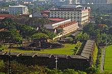
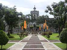
The center of education since the colonial period, Manila — particularly Intramuros — is home to several Philippine universities and colleges as well as its oldest ones. It served as the home of the University of Santo Tomas (1611), Colegio de San Juan de Letran (1620), Ateneo de Manila University (1859), Lyceum of the Philippines University and the Mapua Institute of Technology. Only Colegio de San Juan de Letran (1620) remains at Intramuros; the University of Santo Tomas transferred to a new campus at Sampaloc in 1927, and Ateneo left Intramuros for Loyola Heights, Quezon City (while still retaining "de Manila" in its name) in 1952.
The University of the City of Manila (Pamantasan ng Lungsod ng Maynila) located at Intramuros, and Universidad de Manila located just outside the walled city, are both owned and operated by the Manila city government.
The University of the Philippines (1908), the premier state university, was established in Ermita, Manila. It moved its central administrative offices from Manila to Diliman in 1949 and eventually made the original campus the University of the Philippines Manila – the oldest of the constituent universities of the University of the Philippines System and the center of health sciences education in the country.[233] The city is also the site of the main campus of the Polytechnic University of the Philippines, the largest university in the country in terms of student population.[234]
The University Belt refers to the area where there is a high concentration or a cluster of colleges and universities in the city and it is commonly understood as the one where the San Miguel, Quiapo and Sampaloc districts meet. Generally, it includes the western end of España Boulevard, Nicanor Reyes St. (formerly Morayta St.), the eastern end of Claro M. Recto Avenue (formerly Azcarraga), Legarda Avenue, Mendiola Street, and the different side streets. Each of the colleges and universities found here are at a short walking distance of each other. Another cluster of colleges lies along the southern bank of the Pasig River, mostly at the Intramuros and Ermita districts, and still a smaller cluster is found at the southernmost part of Malate near the city limits such as the private co-educational institution of De La Salle University, the largest of all De La Salle University System of schools.
The Division of the City Schools of Manila, a branch of the Department of Education, refers to the city's three-tier public education system. It governs the 71 public elementary schools, 32 public high schools.[235] The city also contains the Manila Science High School, the pilot science high school of the Philippines.
Notable people
Sister cities
Asia


Europe
Americas


.svg.png)


International relations
Consulates
| Country | Type | Ref. |
|---|---|---|
| Canada | Consular agency | [265] |
| United States | Consular agency | [266] |
| Vietnam | Consular agency | |
| The Russian Federation | Honorary consul | [267] |
| Finland | Honorary consul | [268] |
| France | Honorary consul | [269] |
| Mexico | Honorary consul | [270] |
| Poland | Honorary consul | [271] |
| Spain | Honorary consul | [272] |
| United Kingdom | Honorary consul | [273] |
| Serbia | Honorary consul |
See also
- Cities of the Philippines
- List of cities in the Philippines
- Greater Manila Area
- Mega Manila
- Imperial Manila
- Rajahnate of Maynila
- Rizal Avenue
- Hidalgo Street
Notes
- The city limits was at Vicente Sotto Street. The rest of the place south of the street belongs to Pasay. Buildings and structures in CCP that falls under the jurisdiction of Manila includes the National Theater.
References
- "'Pearl of Orient' Stripped of Food; Manila, Before Pearl Harbor, Had Been Prosperous—Its Harbor One, of Best Focus for Two Attacks Osmeña Succeeded Quezon". New York Times. February 5, 1945. Retrieved March 3, 2014.
Manila, modernized and elevated to the status of a metropolis by American engineering skill, was before Pearl Harbor a city of 623,000 population, contained in an area of fourteen square miles.
- "Cities". Quezon City, Philippines: Department of the Interior and Local Government. Archived from the original on March 9, 2013. Retrieved November 30, 2012.
- "An Update on the Earthquake Hazards and Risk Assessment of Greater Metropolitan Manila Area" (PDF). Philippine Institute of Volcanology and Seismology. November 14, 2013. Archived from the original (PDF) on June 24, 2016. Retrieved May 16, 2016.
- "Enhancing Risk Analysis Capacities for Flood, Tropical Cyclone Severe Wind and Earthquake for the Greater Metro Manila Area Component 5 – Earthquake Risk Analysis" (PDF). Philippine Institute of Volcanology and Seismology and Geoscience Australia. Retrieved May 16, 2016.
- Census of Population (2015). Highlights of the Philippine Population 2015 Census of Population. PSA. Retrieved June 20, 2016.
- "Philippine Population Density (Based on the 2015 Census of Population)". Philippine Statistics Authority. Retrieved November 2, 2017.
- Template:Cite webtitle=Demographia World Urban Areas PDF (March 2013)
- This is the original Spanish, even used by José Rizal in El filibusterismo.
- "PSA releases the 2015 Municipal and City Level Poverty Estimates". Quezon City, Philippines. Retrieved January 1, 2020.
- Sub-national HDI. "Area Database – Global Data Lab". hdi.globaldatalab.org.
- "Manila—the world's most densely-populated cit". Philippine Daily Inquirer. October 7, 2018.
- "Annual Audit Report: City of Manila" (PDF). 2014. Archived from the original on November 4, 2016. Retrieved November 4, 2016.
- Frank, Andre G. (1998). ReOrient: Global Economy in the Asian Age. Berkeley: University of California Press. pp. 131.
- Lozada, Bong (March 27, 2014). "Metro Manila is world's second riskiest capital to live in–poll". Philippine Daily Inquirer. Retrieved April 9, 2014.
- "Global Metro Monitor". Brookings Institution. January 22, 2015. Retrieved April 12, 2017.
- Cruz, Isagani (December 17, 2009). "The first university". The Philippine Star. Retrieved January 10, 2018.
- "22 Things We No Longer See in Manila". FilipiKnow.net. July 14, 2014. Retrieved January 24, 2018.
- "Quiapo underpass for pedestrians, not business". Concept News Central. December 23, 2016. Archived from the original on January 10, 2018. Retrieved January 9, 2018.
- "A Brief History of Manila Science High School". Manila Science High School. Retrieved January 9, 2018.
- "Railway Operations". Light Rail Transit Authority. Archived from the original on January 9, 2018. Retrieved January 9, 2018.
- "Highlights of the Philippine Population 2015 Census of Population". Philippine Statistics Authority. May 19, 2016. Retrieved April 12, 2017.
- "GRDP Tables 2015 (as of July 2016)". Philippine Statistics Authority. Retrieved April 12, 2017.
- "GaWC – The World According to GaWC 2018". www.lboro.ac.uk. Retrieved February 28, 2020.
- "Brookings – Global Metro Monitor 2018". www.brookings.edu. Retrieved April 6, 2020.
- "The Global Financial Centres Index 27" (PDF). Long Finance. March 2020. Retrieved April 5, 2020.
- Baumgartner, Joseph (March 1975). "Manila — Maynilad or Maynila?". Philippine Quarterly of Culture and Society. 3 (1): 52–54. JSTOR 29791188.
- Chamberlain, Alexander F. (1901). "Philippine Studies: V. The Origin of the Name Manila". The American Antiquarian and Oriental Journal. 23 (5): 33.
- "Tayum". Philippine Medicinal Plants. Retrieved August 20, 2018.
- "Ixora manila Blanco". World Marine Species Database. Retrieved August 20, 2018.
- Merrill, Elmer Drew (1903). A Dictionary of the Plant Names of the Philippine Islands. Manila: Bureau of Public Printing.
- Aloma Monte de los Santos (1994). Parish of Santo Niño de Molino – Bacoor, Cavite – 1984–1994: The Making of a Parish. Parish of Santo Niño de Molino. Retrieved August 20, 2018.
- Ambeth Ocampo (June 25, 2008), Looking Back: Pre-Spanish Manila, Philippine Daily Inquirer, archived from the original on June 28, 2008, retrieved August 21, 2018
- Ocampo, Ambeth R. (1990). Looking Back, Volume 1. Anvil Publishing Inc. ISBN 9789712700583. Retrieved August 21, 2018.
- Nakpil, Julio. "A Suggestion to the Tagalistas to Elucidate the Origin of the Name of the Capital City of the Philippines: Manila. Which of these Three Terms or Names Is the More Accurate: Maynilad, Manilad, or Manila?". 26 August 1940.
- Blair and Robertson, The Philippine Islands, 1493–1898, Vol. VIII, p. 96-141. The Arthur H. Clarke Company.; Census of the Philippines, 1903
- Velasquez-Ty, Catalina; García, Tomas; Maceda, Antonio J. (1955). Your Country and Mine.
- An example is: Saenger, Peter (June 29, 2013). Mangrove Ecology, Silviculture and Conservation. Springer Science & Business Media. p. 19. ISBN 9789401599627.
- Mijares, Armand Salvador B. (2006). .The Early Austronesian Migration To Luzon: Perspectives From The Peñablanca Cave Sites Archived July 7, 2014, at the Wayback Machine. Bulletin of the Indo-Pacific Prehistory Association 26: 72–78.
- Junker, Laura Lee (2000). Raiding, Trading, and Feasting: The Political Economy of Philippine Chiefdoms. Quezon City: Ateneo de Manila University Press. pp. 184–192. ISBN 978-9715503471.
- Gerini, G. E. (1905). "The Nagarakretagama List of Countries on the Indo-Chinese Mainland (Circâ 1380 A.D.)". The Journal of the Royal Asiatic Society of Great Britain and Ireland. 37 (July 1905): 485–511. doi:10.1017/S0035869X00033517. JSTOR 25210168.CS1 maint: ref=harv (link)
- "Pusat Sejarah Brunei" (in Malay). Government of Brunei Darussalam. Archived from the original on April 15, 2015. Retrieved March 3, 2014.
- Agoncillo 1990, p. 22
- Wright, Hamilton M. (1907). "A Handbook of the Philippines", p. 143. A.C. McClurcg & Co., Chicago.
- Kane, Herb Kawainui (1996). "The Manila Galleons". In Bob Dye (ed.). Hawaiʻ Chronicles: Island History from the Pages of Honolulu Magazine. I. Honolulu: University of Hawaii Press. pp. 25–32. ISBN 978-0-8248-1829-6.
- Peter Borschberg (2015). Journal, Memorials and Letters of Cornelis Matelieff de Jonge. Security, Diplomacy and Commerce in 17th-Century Southeast Asia. Singapore: NUS Press. pp. 82, 84, 126, 421. Retrieved August 30, 2015.
- Zamboangueño Chavacano: Philippine Spanish Creole or Filipinized Spanish Creole? By Tyron Judes D. Casumpang (Page 3)
- "Manila (Philippines)". Britannica. Retrieved March 3, 2014.
- Backhouse, Thomas (1765). The Secretary at War to Mr. Secretary Conway. London: British Library. pp. v. 40.
- Fish 2003, p. 158
- "Wars and Battles: Treaty of Paris (1763)". www.u-s-history.com.
- Barrows, David (2014). "A History of the Philippines". Guttenburg Free Online E-books. 1: 179.
Within the walls, there were some six hundred houses of a private nature, most of them built of stone and tile, and an equal number outside in the suburbs, or "arrabales," all occupied by Spaniards ("todos son vivienda y poblacion de los Españoles"). This gives some twelve hundred Spanish families or establishments, exclusive of the religious, who in Manila numbered at least one hundred and fifty, the garrison, at certain times, about four hundred trained Spanish soldiers who had seen service in Holland and the Low Countries, and the official classes.
- Raitisoja, Geni " Chinatown Manila: Oldest in the world" Archived April 2, 2011, at the Wayback Machine, Tradio86.com, July 8, 2006, accessed March 19, 2011.
- "In 1637 the military force maintained in the islands consisted of one thousand seven hundred and two Spaniards and one hundred and forty Indians." ~Memorial de D. Juan Grau y Monfalcon, Procurador General de las Islas Filipinas, Docs. Inéditos del Archivo de Indias, vi, p. 425. "In 1787 the garrison at Manila consisted of one regiment of Mexicans comprising one thousand three hundred men, two artillery companies of eighty men each, three cavalry companies of fifty men each." La Pérouse, ii, p. 368.
- Barrows, David (2014). "A History of the Philippines". Guttenburg Free Online E-books. 1: 229.
Reforms under General Arandía.—The demoralization and misery with which Obando's rule closed were relieved somewhat by the capable government of Arandía, who succeeded him. Arandía was one of the few men of talent, energy, and integrity who stood at the head of affairs in these islands during two centuries. He reformed the greatly disorganized military force, establishing what was known as the "Regiment of the King," made up very largely of Mexican soldiers. He also formed a corps of artillerists composed of Filipinos. These were regular troops, who received from Arandía sufficient pay to enable them to live decently and like an army.
- "West Coast Of The Island Of Luzon | Tourist Attractions". Archived from the original on December 6, 2016. Retrieved December 6, 2016.
- John. M. Lipski, with P. Mühlhaüsler and F. Duthin (1996). "Spanish in the Pacific" (PDF). In Stephen Adolphe Wurm & Peter Mühlhäusler (ed.). Atlas of Languages of Intercultural Communication in the Pacific, Asia, and the Americas: Texts, Volume 2. Walter de Gruyter. p. 276. ISBN 9783110134179.
- The Age of Trade: The Manila Galleons and the Dawn of the Global Economy by Arturo Giraldez
- Bartolomé de Letona, La perfecta religiosa (Puebla, 1662), as quoted in Irving, Colonial Counterpoint, page 245
- "Connecting the Indies: the hispano-asian Pacific world in early Modern Global History". ResearchGate.
- Fundación Santa María (Madrid) 1994, p. 508
- John Bowring, "Travels in the Philippines", p. 18, London, 1875
- Olsen, Rosalinda N. "Semantics of Colonization and Revolution". www.bulatlat.com. Retrieved January 8, 2011.
- The text of the amended version published by General Otis is quoted in its entirety in José Roca de Togores y Saravia; Remigio Garcia; National Historical Institute (Philippines) (2003), Blockade and siege of Manila, National Historical Institute, pp. 148–150, ISBN 978-971-538-167-3
See also s:Letter from E.S. Otis to the inhabitants of the Philippine Islands, January 4, 1899. - Joaquin, Nick (1990). Manila My Manila. Vera-Reyes, Inc. p. 137, 178.
- Moore 1921, p. 162.
- Moore 1921, p. 162B.
- Moore 1921, p. 180.
- White, Matthew. "Death Tolls for the Man-made Megadeaths of the 20th Century". Retrieved August 1, 2007.
- Manila, My Manila by Nick Joaquín
- https://news.abs-cbn.com/lifestyle/12/25/12/filipinos-among-most-generous-study-says Filipinos among most generous, study says By Jojo Malig ABS-CBN NEWS
- https://www.christianitytoday.com/news/2013/july/missionaries-countries-sent-received-csgc-gordon-conwell.html Christianity Today: "Missionaries by top countries sent or received."
- News, Arianne Merez, ABS-CBN. "PH among world's most religious countries: study". ABS-CBN News.
- "Milestone in History" Archived March 7, 2016, at the Wayback Machine. Quezon City Official Website. Retrieved April 22, 2013.
- Hancock 2000, p. 16
- "Presidential Decree No. 824 November 7, 1975". The LawPhil Project. Retrieved April 22, 2013.
- "Presidential Decree No. 940 June 24, 1976". Chan C. Robles Virtual Law Library. Retrieved April 22, 2013.
- Lico, Gerard. Edifice Complex: Power, Myth, and Marcos State Architecture. Quezon City: Ateneo de Manila University Press, 2003.
- "Edsa people Power 1 Philippines". Angela Stuart-Santiago. Retrieved December 3, 2007.
- Mundo, Sheryl (December 1, 2009). "It's Atienza vs. Lim Part 2 in Manila". Manila: ABS-CBN News and Current Affairs. Archived from the original on December 3, 2009. Retrieved March 3, 2014.
Environment Secretary Jose 'Lito' Atienza will get to tangle again with incumbent Manila Alfredo Lim in the coming 2010 elections.
- Legaspi, Amita (July 17, 2008). "Councilor files raps vs Lim, Manila execs before CHR". GMA News. Retrieved March 4, 2014.
- "Mayor Lim charged anew with graft over rehabilitation of public schools". The Daily Tribune. Archived from the original on June 11, 2011. Retrieved June 25, 2012.
- "Isko Moreno, 28 councilors file complaint vs Lim". ABS-CBN News and Current Affairs. Retrieved June 25, 2012.
- Ranada, Pia (August 4, 2014). "Pia Cayetano to look into Torre de Manila violations". Rappler. Retrieved April 28, 2017.
- Dario, Dethan (April 28, 2017). "Timeline: Tracking the Torre De Manila case". The Philippine Star. Archived from the original on April 28, 2017. Retrieved April 28, 2017.
- "Duterte says 'comfort woman' statue a 'constitutional right'". ABS-CBN News. January 18, 2018. Retrieved January 21, 2018.
- "Japan voices regret to Duterte over 'comfort women' statue". ABS-CBN News. January 10, 2018. Retrieved January 21, 2018.
- Lopez, Tony (June 10, 2016). "Erap's hairline victory". The Standard Philippines. Retrieved June 22, 2016.
- "10 Heritage Sites in Manila That Need Your Attention". SPOT.PH.
- "NHCP stops Erap's demolition of postwar Santa Cruz Building in Escolta". Inquirer Lifestyle. June 2, 2019.
- "Almost already gone: Santa Cruz Bldg. in Escolta saved from demolition". June 3, 2019.
- Rola, Alyssa. "Rizal Memorial saved from demolition by NHCP". Rappler.
- "Estrada declares Manila City government 'debt-free' after paying off GSIS arrears". Manila Bulletin News.
- Tomacruz, Sofia. "Erap leaves Manila in debt by P4.4 billion – COA". Rappler.
- Modesto, Catherine A. (May 14, 2019). "Isko Moreno is new Manila mayor, defeats 'Goliaths' in politics". The Manila Times. Retrieved May 14, 2019.
- Esguerra, Christian V. (May 14, 2019). "Ex-scavenger beats ex-president: Moreno in, Estrada out as Manila mayor". ABS-CBN News. Retrieved May 14, 2019.
- Maru, Davinci (May 14, 2019). "End of an era for Estrada-Ejercito political clan?". ABS-CBN News. Retrieved May 14, 2019.
- Cabico, Gaea Katreena (July 10, 2019). "Recto: Isko's efforts to fix Manila show charter change not sole solution". Philstar Global. Retrieved July 11, 2019.
- "Perks and privileges for Manila senior citizens". BusinessMirror. September 28, 2019. Retrieved March 22, 2020.
- "Moreno signs ordinance granting monthly allowance for qualified PLM, UdM students". CNN Philippines. July 31, 2019. Retrieved March 22, 2020.
- "Students of PLM, UdM start receiving P1,000 allowance from Manila gov't". Inquirer.net. January 28, 2020. Retrieved March 22, 2020.
- Ramos, Marjaleen (July 1, 2018). "Careful now: Catcalling is banned in Manila". Manila Bulletin. Retrieved July 1, 2018.
- Caliwan, Christopher Lloyd (September 25, 2017). "SC okays curfew for minors in QC, but not in Manila, Navotas". News5. Retrieved September 27, 2017.
- Aberia, Jaimie Rose (September 27, 2017). "Manila city council planning to revise existing curfew ordinance". The Manila Bulletin. Retrieved September 27, 2017.
- "Manila may no longer be the PH capital under federal gov't: Cha-cha panel member". ABS-CBN News. June 19, 2018. Retrieved June 21, 2018.
- Aurelio, Julie M. (June 19, 2018). "Roque: No problem if Manila no longer capital under federal gov't". Inquirer News. Retrieved June 21, 2018.
- Talabong, Rambo (March 12, 2020). "Metro Manila to be placed on lockdown due to coronavirus outbreak". Rappler. Retrieved March 20, 2020.
- "GUIDELINES: Luzon 'enhanced community quarantine'". Rappler.com. March 16, 2020. Retrieved March 20, 2020.
- "Geography of Manila". HowStuffWorks. Archived from the original on February 2, 2014. Retrieved March 4, 2014.
- "Environment — Manila". City-Data. Retrieved February 26, 2017.
- Cabuenas, Jon Viktor D. (October 26, 2017). "Waterfront Manila to develop man-made island in Manila Bay". GMA News Online. Retrieved October 26, 2017.
- Talabong, Rambo (May 12, 2017). "Manila to relocate 7,000 families in esteros". Rappler. Retrieved June 12, 2017.
- Rambo Talabong (June 6, 2017). "Estrada approves building 3 islands at Manila Bay for new commercial district". Rappler. Retrieved June 12, 2017.
- See, Aie Balagtas (June 7, 2017). "Erap OKs fourth reclamation project in Manila Bay". Philippine Daily Inquirer. Retrieved June 12, 2017.
- "Philippines, Netherlands Sign MOU on Manila Bay Development". National Economic and Development Authority. January 22, 2018. Retrieved January 29, 2018.
- "Temperatures drop further in Baguio, MM". Philippine Star. Archived from the original on October 25, 2014. Retrieved October 12, 2014.
- "Metro Manila temperature soars to 36.2C". ABS-CBN. Retrieved October 12, 2014.
- "Manila". Jeepneyguide. Retrieved March 4, 2014.
- "Port Area Manila Climatological Normal Values". Philippine Atmospheric, Geophysical and Astronomical Services Administration. Archived from the original on September 19, 2018. Retrieved December 17, 2019.
- "Port Area Manila Climatological Extremes". Philippine Atmospheric, Geophysical and Astronomical Services Administration. Archived from the original on September 19, 2018. Retrieved December 17, 2019.
- Cappelen, John; Jensen, Jens. "Filippinerne – Manila, Luzon" (PDF). Climate Data for Selected Stations (1931–1960) (in Danish). Danish Meteorological Institute. Archived from the original (PDF) on April 27, 2013. Retrieved December 17, 2019.
- Nelson, Alan R.; Personius, Stephen F.; Rimando, Rolly E.; Punongbayan, Raymundo S.; Tungol, Norman; Mirabueno, Hannah; Rasdas, Ariel (2000). "Multiple Large Earthquakes in the Past 1500 Years on a Fault in Metropolitan Manila, the Philippines". Bulletin of the Seismological Society of America. 90 (1): 84. Bibcode:2000BuSSA..90...73N. doi:10.1785/0119990002.
- Rimando, Rolly; Rolly E. Rimando; Peter L.K. Knuepfer (February 10, 2004). "Neotectonics of the Marikina Valley fault system (MVFS) and tectonic framework of structures in northern and central Luzon, Philippines". Tectonophysics. 415 (1–4): 17–38. Bibcode:2006Tectp.415...17R. doi:10.1016/j.tecto.2005.11.009.
- "Fire and Quake in the construction of old Manila" Archived February 3, 2013, at the Wayback Machine. The Frequency of Earthquakes in Manila. Retrieved November 22, 2013.
- "The City of God: Churches, Convents and Monasteries" Discovering Philippines. Retrieved July 6, 2011.
- Atlantic Oceanographic and Meteorological Laboratory, Hurricane Research Division. "Frequently Asked Questions: What are the upcoming tropical cyclone names?". NOAA. Retrieved December 11, 2006.
- Tharoor, Ishaan (September 29, 2009). "The Manila Floods: Why Wasn't the City Prepared?". TIME. Retrieved March 4, 2014.
- "Situation Report: Ondoy" (PDF). Archived from the original (PDF) on May 30, 2011. Retrieved September 29, 2009.
- "City Profiles:Manila, Philippines". United Nations. Archived from the original on August 15, 2010. Retrieved March 4, 2010.
- Alave, Kristine L. (August 18, 2004). "Metro Manila Air Polluted Beyond Acceptable Levels". Clean Air Initiative – Asia. Manila: Cleanairnet.org. Archived from the original on December 3, 2005. Retrieved March 4, 2014.
- "Pollustion Adversely Affects 98% of Metro Manila Residents". Hong Kong: Cleanairnet.org. January 31, 2005. Archived from the original on April 27, 2006. Retrieved March 4, 2014.
- "Air pollution is killing Manila". GetRealPhilippines. Archived from the original on March 7, 2016. Retrieved June 18, 2010.
- Fajardo, Feliciano (1995). Economics. Philippines: Rex Bookstore, Inc. p. 357. ISBN 978-971-23-1794-1. Retrieved May 6, 2010.
- de Guzman, Lawrence (November 11, 2006). "Pasig now one of world's most polluted rivers". Philippine Daily Inquirer. Archived from the original on May 30, 2012. Retrieved June 18, 2010.
- Badilla, Nelson (December 28, 2017). "Quezon City, Manila, Caloocan biggest waste producers". The Manila Times. Retrieved December 28, 2017.
- "Presidential Decree Number 274, Pertaining to the Preservation, Beautification, Improvement, and Gainful Utilization of the Pasig River, Providing for the Regulation and Control of the Pollution of the River and Its Banks In Order to Enhance Its Development, Thereby Maximizing Its Utilization for Socio-Economic Purposes". Archived from the original on May 3, 2007. Retrieved March 4, 2014.
- Santelices, Menchit. "A dying river comes back to life". Philippine Information Agency. Archived from the original on March 16, 2008.
- "Estero de San Miguel: The great transformation". Yahoo! Philippines. Retrieved February 5, 2013.
- "Republic Act No. 409". Official Gazette of the Republic of the Philippines. Retrieved June 30, 2015.
- "Manila : : Architecture". Encyclopædia Britannica. Retrieved January 29, 2015.
- "Escolta Street tour shows retro architecture and why it's worth reviving as a gimmick place". News5. Archived from the original on March 2, 2015. Retrieved January 30, 2015.
- Jenny F. Manongdo (June 13, 2016). "Culture agency moves to restore 'Manila, Paris of the East' image". Manila Bulletin. Retrieved July 6, 2016.
- "Let's bring back the glory days of Manila with the rehabilitation of the Met!". Coconuts Manila. June 17, 2016. Retrieved July 6, 2016.
- Lila Ramos Shahani (May 11, 2015). "Living on a Fault Line: Manila in a 7.2 Earthquake". The Philippine Star. Archived from the original on May 18, 2015. Retrieved May 26, 2015.
- Census of Population (2015). "National Capital Region (NCR)". Total Population by Province, City, Municipality and Barangay. PSA. Retrieved June 20, 2016.
- Census of Population and Housing (2010). "National Capital Region (NCR)". Total Population by Province, City, Municipality and Barangay. NSO. Retrieved June 29, 2016.
- Censuses of Population (1903–2007). "National Capital Region (NCR)". Table 1. Population Enumerated in Various Censuses by Province/Highly Urbanized City: 1903 to 2007. NSO.
- "Province of Metro Manila, 1st (Not a Province)". Municipality Population Data. Local Water Utilities Administration Research Division. Retrieved December 17, 2016.
- "Manila – The city, History, Sister cities" (PDF). Cambridge Encyclopedia. Archived from the original (PDF) on November 21, 2008. Retrieved April 4, 2010. (from Webcite archive)
- "Area, population, decennial growth rate and density for 2001 and 2011 at a glance for West Bengal and the districts: provisional population totals paper 1 of 2011: West Bengal". Registrar General & Census Commissioner, India. Retrieved January 26, 2012.
- "The Philippines: The Spanish Period". Encyclopædia Britannica. Retrieved April 8, 2017.
- "Population estimates for Metro Manila, Philippines, 1950–2015".
- "Profile of Makati City" (PDF). Makati City Government.
- Mercurio, Richmond S. "Philippine cities with over 1M population to nearly triple by 2025". Philippine Star. Retrieved April 8, 2017.
- "More than 3 million Chinese allowed entry into Philippines since 2016 — Immigration data | Philstar.com". philstar.com. Retrieved October 4, 2018.
- Ranada, Pia (January 5, 2016). "A look at the state of crime, drugs in the Philippines". Rappler. Retrieved April 26, 2016.
- "Top 15 cities with highest index crimes". ABS-CBN News. April 1, 2016. Retrieved December 5, 2017.
- Aberia, Jaimie Rose (October 2, 2017). "Crime rate in Manila drops by 38% for past 12 months". Manila Bulletin. Retrieved December 5, 2017.
- Casas, Bill (August 22, 2017). "MPD is top NCR police district". Manila Standard. Retrieved March 3, 2018.
- "Manila ("Maynila")" (PDF). Archived from the original (PDF) on January 25, 2011. Retrieved October 22, 2010.
- "Manila churches under tight guard". The Manila Times. December 15, 2016. Retrieved December 21, 2016.
- "Wow Philippines: Manila-Cosmopolitan City of the Philippines". Department of Tourism. Archived from the original on July 30, 2008. Retrieved March 4, 2014.
- "World Heritage: San Sebastian Church". Tentative List for the World Heritage List. UNESCO. Retrieved April 20, 2008.
- Tony Macapagal (February 8, 2017). "Manila dads hail fast CTO service". The Standard. Retrieved February 10, 2017.
- "Rankings". Cities and Municipalities Competitiveness Index. Archived from the original on January 10, 2017. Retrieved January 9, 2017.
- Richmond Mercurio (July 15, 2016). "Quezon City emerges as most competitive city". Philippine Star official website. Archived from the original on August 29, 2016. Retrieved July 19, 2016.
- Rex Remitio (July 17, 2015). "Manila is Philippines' most competitive city – NCC". CNN Philippines. Archived from the original on August 18, 2016. Retrieved July 19, 2016.
- "Five best PH cities to launch a start-up business". Manila Bulletin. March 2, 2017. Retrieved March 3, 2017.
- "International Container Terminal Services Inc". Philippine Stock Exchange. Archived from the original on February 29, 2008. Retrieved October 22, 2008.
- "Asia's 200 Best Under A Billion: International Container Terminal Services". Forbes. September 27, 2007. Retrieved October 22, 2008.
- "Plan to turn Chinatown into BPO hub gains ground". ABS-CBN News. Retrieved March 1, 2013.
- "Tutuban Center may become Manila's busiest transfer station". ABS-CBN News. Retrieved March 21, 2015.
- "Estrada: Oil depot closed by July 15". The Philippine Daily Inquirer. December 16, 2014. Retrieved February 5, 2015.
- "Pandacan oil depot 'decontamination' pushed after Big 3 exit". The Philippine Daily Inquirer. December 21, 2014. Retrieved February 5, 2015.
- MSN Encarta: Manila. MSN Encarta. Archived from the original on October 28, 2009. Retrieved March 4, 2014.
- "MB Website". Manila Bulletin.
- Andrade, Jeannette (December 1, 2007). "Lino Brocka, 3 others installed on remembrance wall". Philippine Daily Inquirer. Archived from the original on May 2, 2014. Retrieved July 28, 2013.
- "BSP Website". Central Bank of the Phils.
- "Unilever Philippines". Unilever.
- "10 Best Places to Visit in Manila with Kids". Gofamgo.
- "Republic Act No. 9593 otherwise known as Tourism Act of 2009 and Its Implementing Rules and Regulations" (PDF). Department of Tourism. Archived from the original (PDF) on April 30, 2015. Retrieved March 8, 2015.
- Gwen de la Cruz (January 12, 2015). "FAST FACTS: Rizal Park". Rappler. Retrieved March 8, 2015.
- "Rizal Park". WordTravels. Archived from the original on April 20, 2009. Retrieved March 4, 2014.
- Jovic Lee (July 20, 2014). "Intramuros cocheros: Hooves, history and hope for a fare hike". INQUIRER.net. Retrieved March 23, 2015.
- "Medical Tourism, Treatments and Surgery in Manila". World Guides. Retrieved October 27, 2014.
- Edgardo S. Tugade (June 1, 2014). "Challenges to PH medical tourism". The Manila Times. Retrieved October 27, 2014.
- "Manila 11th most attractive shopping destination in Asia Pacific –study — Yahoo! News Philippines". Ph.news.yahoo.com. November 1, 2012. Retrieved March 12, 2013.
- Arveen, Kim (October 30, 2012). "Manila outperforms 15 Asian cities in 'shopping' index — Yahoo! News Philippines". Ph.news.yahoo.com. Retrieved March 12, 2013.
- "More cops on Manila streets". Tempo. November 27, 2017. Retrieved November 28, 2017.
- "Manila". Robinsons Malls. Archived from the original on March 8, 2013. Retrieved March 12, 2013.
- "Miss Earth candidates visits 100 Revolving Restaurant". Retrieved January 12, 2012.
- "Manila: Sports". Retrieved January 15, 2010.
- Talao, Tito (March 10, 2004). "Baseball loses no time in preparing for SEAG". Manila Bulletin. Archived from the original on September 13, 2012. Retrieved March 4, 2014.
- "World Cup of Pool begins". ABS-CBNnews.com. September 7, 2010. Retrieved July 4, 2011.
- Fenix, Ryan (June 4, 2011). "All systems go for Azkals' World Cup qualifier at Rizal Memorial". Interaksyon.com. Archived from the original on January 26, 2013. Retrieved July 4, 2011.
- "Teams ready for RWC Qualifiers in Manila". Rugbyworldcup.com. April 14, 2012. Archived from the original on April 17, 2012. Retrieved April 14, 2012.
- "Living in Manila". InterNations. Retrieved October 25, 2017.
- "Income Classification Per DOF Order No. 23-08, dated July 29, 2008" (PDF). Bureau of Local Government Finance. Archived from the original (PDF) on December 31, 2016. Retrieved December 31, 2016.
- "Position Classification and Compensation Scheme in Local Government Units" (PDF). Department of Budget and Management.
- "2018 Annual Audit Reports". Commission on Audit. Retrieved July 8, 2019.
- Lopez, Virgil (April 25, 2017). "SC picks PHL flag-inspired design for new 'green' building in Taguig". GMA News. Retrieved April 27, 2017.
- "Quezon City, Makati richest cities in RP". Philippine Today US. Archived from the original on October 24, 2011. Retrieved April 18, 2011.
- "2015 Annual Financial Reports for Local Government Units (Volume III)". Commission on Audit. Archived from the original on December 1, 2016. Retrieved December 1, 2016.
- Santos, Reynaldo Jr. (October 24, 2013). "Barangay in numbers". Rappler. Retrieved April 27, 2016.
- Macairan, Evelyn (August 15, 2007). "Manila councilor wants fewer barangays". The Philippine Star. Retrieved April 27, 2016.
- "Population Counts by Legislative District (Based on the 2015 Census of Population)". Philippine Statistics Authority. Retrieved November 2, 2017.
- "Aquino admin winds down with Manila housing project". Inquirer.net. June 30, 2016. Retrieved July 11, 2019.
- "Mayor Isko wants to improve Manila's old tenements, relocate residents". GMA News Online. July 10, 2019. Retrieved July 11, 2019.
- "Manila gov't working on vertical housing projects for illegal settlers". GMA News Online. January 7, 2020. Retrieved February 28, 2020.
- "Isko on 2020 focus: Tondominium, reviving Manila". ABS-CBN News. January 7, 2020. Retrieved February 28, 2020.
- "Transportation in the Philippines". AsianInfo.org. Retrieved April 24, 2010.
- Clapano, Jose Rodel (September 18, 2016). "Manila: No more trikes, pedicabs next month". The Philippine Star. Retrieved September 19, 2016.
- Coconuts Manila (September 18, 2016). "Manila will say goodbye to old school tricycles and pedicabs on Oct 15". Retrieved September 19, 2016.
- "City of Manila to remove old, rusty tricycles from city streets". January 23, 2018. Retrieved January 23, 2018.
- Republic of the Philippines. Office of the President. (July 21, 2005). "SONA 2005 Executive Summary". Archived from the original on May 13, 2010.
- "Waze – Official Blog: Global Driver Satisfaction Index". Retrieved August 12, 2016.
- "World's Densest Cities". Retrieved October 25, 2012.
- "Lacson-España flyover takes off despite protests". August 6, 2012. Retrieved October 25, 2012.
- Tomas S. Noda III (January 28, 2015). "DMCI gets $51.5m rail contract in PH". Retrieved February 1, 2015.
- Rodel Rodis (October 23, 2014). "Manila's traffic jams cost $57 million a day". Retrieved March 20, 2015.
- (The Philippines) Mega Manila Infrastructure Roadmap (Long Version). JICAChannel02: The Official Global Channel of the Japan International Cooperation Agency (JICA). Japan International Cooperation Agency (JICA), National Economic Development Authority (NEDA). June 10, 2014.
- Main Points of the Roadmap (PDF) (Report). Japan International Cooperation Agency. September 2014. Archived from the original (PDF) on October 11, 2014.
- Orozco, G; Zafaralla, M (2011), Socio-Economic Study of Two Major Metro Manila Esteros (PDF), Makati, Philippines: Journal of Environmental Science and Management, archived from the original (PDF) on October 23, 2016, retrieved December 3, 2014
- Inocencio, A; David, C (2001), Public-Private-Community Partnerships in Management and Delivery of Water to Urban Poor: The Case of Metro Manila (PDF), Makati, Philippines: Philippine Institute for Development Studies, archived from the original (PDF) on October 23, 2016, retrieved December 3, 2014
- Joel E. Surbano (January 3, 2016). "Manila hospital going for upgrade". The Standard. Retrieved January 3, 2016.
- Jaime Rose R. Aberia (August 6, 2017). "World-class hospital to rise in Manila for cleft lip, palate patients". Manila Bulletin. Retrieved August 7, 2017.
- Rosabell C. Toledo (August 6, 2017). "Manila mayor eyes founding of PHL's first 'world-class' cleft-palate facility". BusinessMirror. Retrieved August 7, 2017.
- Tianco, Minka Klaudia (February 28, 2020). "First children's surgical hospital in Southeast Asia to be built in Manila". Manila Bulletin. Retrieved February 29, 2020.
- Odronia, Cris G. (February 25, 2017). "Manila intensifies free immunization program". Manila Bulletin. Retrieved February 25, 2017.
- Toledo, Rosabell C. (July 10, 2017). "UN lauds free dialysis center in Manila". BusinessMirror. Retrieved July 15, 2017.
- Cabalza, Dexter (July 9, 2017). "Dialysis center for Manila's poor cited by UN body". Philippine Daily Inquirer. Retrieved July 15, 2017.
- Lalu, Gabriel Pabico (October 24, 2019). "Manila opens country's largest free dialysis facility". Inquirer.net. Retrieved October 26, 2019.
- "Isko opens Philippine's largest dialysis center". PhilStar Global. October 26, 2019. Retrieved October 26, 2019.
- "About UP Manila". University of the Philippines Manila. Archived from the original on February 6, 2013. Retrieved February 5, 2013.
- "PUP: Profile". Polytechnic University of the Philippines. March 30, 2011. Archived from the original on June 21, 2014. Retrieved March 4, 2014.
- Cabayan, Itchie G. (April 7, 2010). "Good education a right, not privilege – Lim". City Government of Manila. Archived from the original on February 23, 2017. Retrieved April 24, 2010.
NO one should be deprived of a sound education for being poor
- Jaimie Rose Aberia (August 16, 2017). "Manila, Bacoor sign sister city accord". Manila Bulletin. Retrieved August 16, 2017.
- "Relationship with Sister Cities: Manila". Bangkok Metropolitan Administration. Retrieved May 27, 2015.
- "Beijing's Sister Cities". eBeijing. Retrieved January 3, 2015.
- "Overview of China-Philippines Bilateral Relations: III. Exchanges and Cooperation in the Fields of Culture, Education, Science and the Military, etc". Embassy of the People's Republic of China in the Republic of the Philippines. March 5, 2009. Retrieved February 4, 2015.
There are 24 pairs of sister-cities or sister-provinces between China and the Philippines, namely: Hangzhou and Baguio City, Guangzhou and Manila City, Shanghai and Metro Manila, Xiamen and Cebu City, Shenyang and Quezon City, Fushun and Lipa City, Hainan and Cebu Province, Sanya and Lapu-Lapu City, Shishi and Naya City, Shandong and Ilocos Norte Province, Zibo and Manduae City, Anhui and Nueva Ecija Province, Hubei and Leyte Province, Liuzhou and Muntinlupa City, Hezhou and San Fernando City, Harbin and Cagayan de Oro City, Laibin and Laoag City, Beijing and Manila City, Jiangxi and Bohol Province, Guangxi Zhuang Autonomous Region and Davao City, Lanzhou and Albay Province, Beihai and Puerto Princessa City, Fujian Province and Laguna Province, Wuxi and Puerto Princessa City.
- "Sisterhood Agreement With Democratic Republic Of Timor Leste". City of Manila. Archived from the original on July 14, 2015.
- "Manila, Bacoor forge sisterhood pact". www.pna.gov.ph.
- "Twin Cities". Hello Haifa. Retrieved August 16, 2016.
- "Sister Cities – Ho Chi Minh City". Ho Chi Minh City. Retrieved February 7, 2015.
- "Sister and Friendship Cities". Archived from the original on February 6, 2015. Retrieved February 7, 2015.
- "About Manila: Sister Cities". City of Manila. Archived from the original on June 11, 2016. Retrieved September 2, 2009.
- "Sister cities, towns and villages of Kyoto Prefecture". Kyoto Prefecture Website. Retrieved February 5, 2015.
- "About Manila: Sister Cities". City of Manila. Archived from the original on June 11, 2016. Retrieved November 24, 2016.
- "Business Partner Cities (BPC), the official website of Osaka city". Archived from the original on January 20, 2013. Retrieved August 5, 2009.
- Todeno, Junhan B. (June 17, 2012). "Flores forges sister city ties with Manila". Marianas Variety. Retrieved November 10, 2015.
- "Shanghai Foreign Affairs". Shfao.gov.cn. Archived from the original on May 18, 2011. Retrieved November 24, 2016.
- "International Sister Cities". Taipei City Council. Retrieved June 3, 2015.
- "Manila-Takatsuki sisterpact". City of Manila. Archived from the original on January 8, 2015. Retrieved January 8, 2015.
- "List of Sister City Affiliations with Japan (by country): Philippines". Singapore: Japan Council of Local Authorities for International Relations (CLAIR, Singapore). February 29, 2012. Retrieved February 4, 2015.
- "How the Filipino hero found his samurai wife in Yokohama". Inquirer.net. Retrieved January 8, 2015.
- "Twin Cities plan will boost Malacca". New Straits Times. Retrieved July 9, 2013.
- "Hermanamientos y Acuerdos con ciudades". Ayuntamiento de Madrid. Retrieved November 24, 2016.
- "Villes jumelées avec la Ville de Nice" (in French). Ville de Nice. Archived from the original on October 29, 2012. Retrieved June 24, 2013.
- "Sister Cities" (in Spanish). Archived from the original on March 7, 2016. Retrieved October 25, 2017.
- "Manila, Philippines". Sister Cities International. Archived from the original on October 27, 2014. Retrieved October 27, 2014.
- "Relaciones internacionales" (in Spanish). Intendencia Municipal de Montevideo. Archived from the original on November 8, 2011. Retrieved December 12, 2011.
- Foreign Relations (June 24, 2005). "Manila-Montreal Sister City Agreement Holds Potential for Better Cooperation". The Republic of the Philippines. Archived from the original on December 5, 2009. Retrieved October 2, 2009.
- "NYC's Partner Cities". New York City Global Partners. Archived from the original on August 14, 2013. Retrieved January 19, 2015.
- "Declaración de Hermanamiento múltiple y solidario de todas las Capitales de Iberoamérica (12–10–82)" (PDF). October 12, 1982. Archived from the original (PDF) on May 10, 2013. Retrieved March 12, 2015.
- "Winnipeg's Sister Cities: Manila (Maynila), Philippines (Republika ng Pilipinas)". Archived from the original on June 4, 2015. Retrieved June 2, 2015.
- "Secretaría de Relaciones Exteriores | Gobierno | gob.mx".
- "Secretaría de Relaciones Exteriores | Gobierno | gob.mx".
- "Secretaría de Relaciones Exteriores | Gobierno | gob.mx".
- "Secretaría de Relaciones Exteriores | Gobierno | gob.mx".
- "Secretaría de Relaciones Exteriores | Gobierno | gob.mx".
- "Secretaría de Relaciones Exteriores | Gobierno | gob.mx".
- "Secretaría de Relaciones Exteriores | Gobierno | gob.mx".
- "Secretaría de Relaciones Exteriores | Gobierno | gob.mx".
- "Secretaría de Relaciones Exteriores | Gobierno | gob.mx".
Sources
- Moore, Charles (1921). "Daniel H. Burnham: Planner of Cities". Houghton Mifflin and Co., Boston and New York.
External links
- Official Website of the City of Manila

| Preceded by Quezon City |
Capital of the Philippines 1976–2019 |
Succeeded by Makati |
| Preceded by Iloilo |
Capital of the Philippines 1571–1948 |
Succeeded by Quezon City |
Places adjacent to Manila | ||||||||||
|---|---|---|---|---|---|---|---|---|---|---|
| ||||||||||
Capital of the Philippines | ||
| Topics |
| |
| Government |
| |
| Districts |
| |
| Congressional Districts |
| |
| ||
| |||||||||||||||||||||||||||||||||||||||||||||||||||||||||||||||||||||||||||||||||||||||||||||||||||||||||||||||||||||||||


| Authority control |
|
|---|