Poblacion
Poblacion or población (literally "town" or "settlement"[1] in Spanish; Tagalog pronunciation: [pobläˈʃo̞n]) is the common term used for the central, downtown, old town or central business district area of a Philippine city or municipality, which may take up the area of a single barangay or multiple barangays. It is sometimes shortened to Pob.
 |
|---|
| This article is part of a series on the politics and government of the Philippines |
|
|
Congress
|
|
Executive
|
|
Judiciary
|
|
Constitutional commissions
|
|
Elections
|
|
Political parties
|
|
|
Related topics
|
|
History
During the Spanish rule, the colonial government founded hundreds of towns and villages across the archipelago modeled on towns and villages in Spain. The authorities often adopted a policy of Reducción, for the resettlement of inhabitants in far-flung scattered barangays to move into a centralized cabecera (town/district capital) where a newly built church and an ayuntamiento (town hall) were situated.[2] This allowed the government to defend, control and Christianize the indigenous population, to conduct population counts, and to collect tributes.
Features
The población is considered the commercial and industrial center of the city or municipality. Most citizens of a city or municipality residing in the outlying barangays and satellite sitios flock to the población on market days (which is set by a local ordinance of the local government) because most local products and goods from the barrios are brought to the public market located in the población. In this way their products could be sold faster by a wide range of buyers, though there are instances where some citizens would choose to go to another town's poblacion because it is closer to their residences. In some cities and towns, the población (usually the areas surrounding the parish church) doubles as an old town district that features one or more of a few remaining Spanish-built structures in the country.
The cabecera (or the población of a municipio/pueblo) has a basic plan, with a plaza mayor, church and attached convento, civic buildings such as the town hall, and houses of prominent Spaniards.[3][4][5]
Other features include the public market, the central elementary school and high school, police station, and hospital.[6]
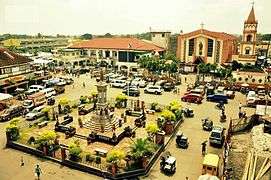 Plaza Rizal at Poblacion, Biñan, Laguna
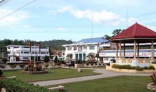 The población of Loboc, Bohol, showing structures typical to most town centres: the plaza, town hall, gazebo, and arena
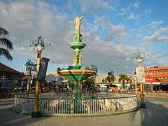 Bonifacio Park at Palaris (Poblacion), San Carlos, Pangasinan
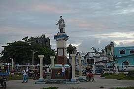 Plaza at Guiuan, Eastern Samar with the church in the background
.jpg) Plaza Rizal at Zamboanga City showing houses with Spanish Colonial architecture
Plaza Rizal at Zamboanga City showing houses with Spanish Colonial architecture
See also
- Barangay
- Purok
- Sitio
References
- "Google Translate". translate.google.com.ph. Retrieved 2017-02-07.
- Constantino, Renato; Constantino, Letizia R. (1975). "Chapter V - The Colonial Landscape". The Philippines: A Past Revisited (Vol. I) (Sixteenth Printing (January 1998) ed.). Manila, Philippines: Renato Constantino. pp. 60–61. ISBN 971-895-800-2. OL 9180911M.
- Abinales, Patricio N.; Amoroso, Donna J. (2005). "New States and Reorientations 1368-1764". State and Society in the Philippines. Lanham, Md.: Rowman & Littlefield. pp. 53, 55. ISBN 0742510247. Retrieved 15 January 2015.
- Alas, José Mario “Pepe”. "28 July 1571: The Foundation Date of the Province of La Laguna". Academia.edu. Retrieved 15 January 2015.
- "The Philippines Then and Now; Spanish Period". Blogspot. 22 May 2009. Retrieved 15 January 2015.
- Halili, Christine N. (2004). Philippine History. Manila: Rex Book Store. p. 86. ISBN 9712339343. Retrieved 11 October 2014.